Irondro – Southern Indian Ocean

Apr. 06, 2020 – NASA Finds Tropical Storm Irondro’s Heavy Rainfall Displaced

NASA analyzed Tropical Storm Irondro’s rainfall and found heaviest rainfall was being pushed far southeast of the center because of strong wind shear.
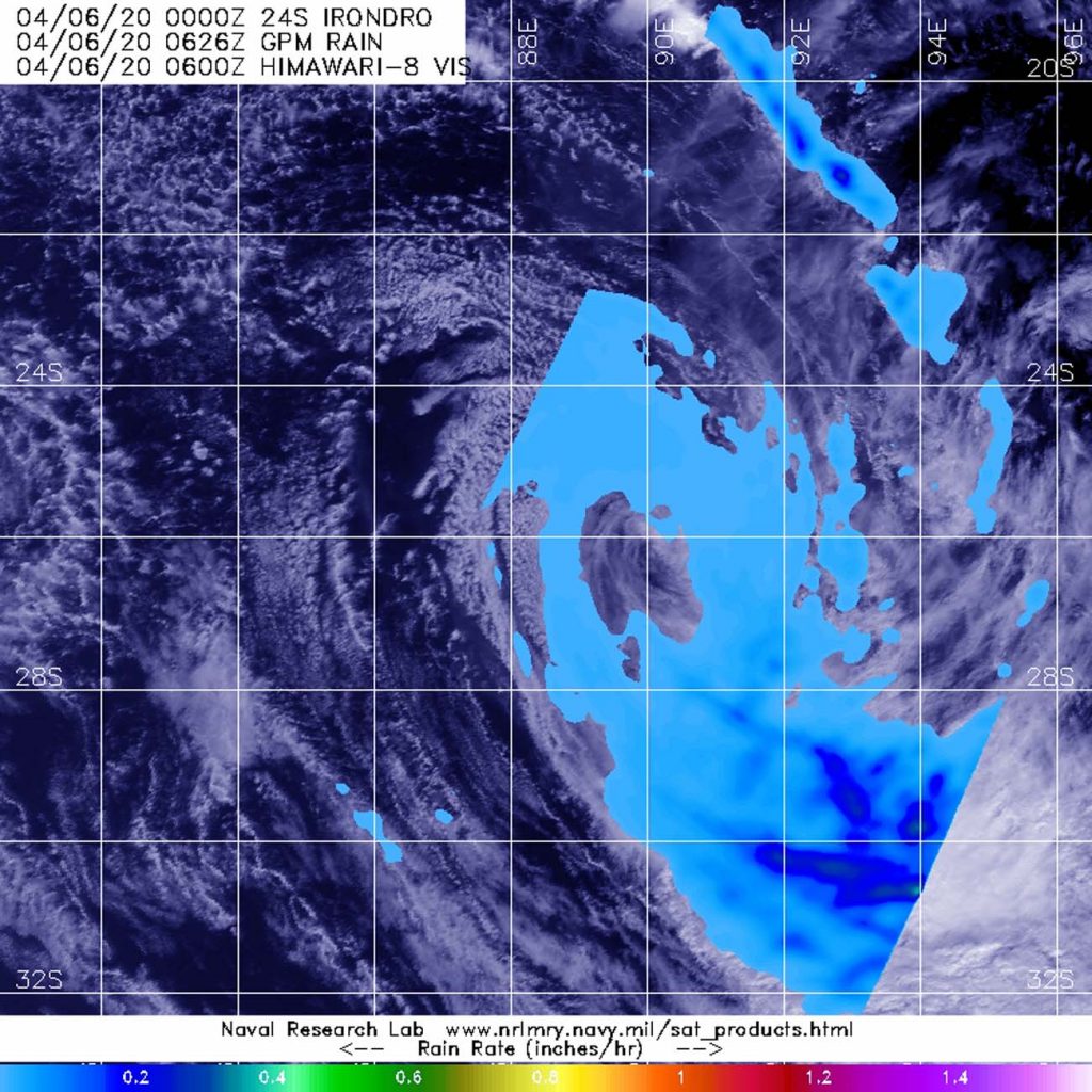
GPM image of Irondro
The GPM core satellite passed over Tropical Storm Irondro on Apr. 6 at 2:26 a.m. EDT (0626 UTC). Heaviest rainfall (orange), located southeast of the center, was falling at a rate 1 inch (25 mm) per hour. Light rain (blue) was found throughout the rest of the storm. Credit: NASA/JAXA/NRL

NASA has the unique capability of peering under the clouds in storms and measuring the rate in which rain is falling. Global Precipitation Measurement mission or GPM core passed over Irondro from its orbit in space and measured rainfall rates throughout the storm on Apr. 6 at 2:26 a.m. EDT (0626 UTC). Heaviest rainfall was being pushed southeast of the center where it was falling at a rate of 1 inch (25 mm) per hour. Light rain was found throughout the rest of the storm.

In general, wind shear is a measure of how the speed and direction of winds change with altitude. Tropical cyclones are like rotating cylinders of winds. Each level needs to be stacked on top each other vertically in order for the storm to maintain strength or intensify. Wind shear occurs when winds at different levels of the atmosphere push against the rotating cylinder of winds, weakening the rotation by pushing it apart at different levels. Winds from the northwest were pushing against the storm and displacing the heaviest rainfall southeast of the center.

On Apr. 6 at 4 a.m. EDT (0900 UTC), the Joint Typhoon Warning Center issued their final warning on Irondro. Despite the wind shear, Tropical Storm Irondro had maximum sustained winds near 40 knots (46 mph/74 kph). Irondro was located near latitude 26.7 degrees south and longitude 89.5 degrees east. Irondro is becoming extra-tropical and is expected to become a cold core low pressure area later in the day.

Typhoons/hurricanes are the most powerful weather events on Earth. NASA’s expertise in space and scientific exploration contributes to essential services provided to the American people by other federal agencies, such as hurricane weather forecasting.

Both the Japan Aerospace Exploration Agency, JAXA and NASA manage GPM.

By Rob Gutro
NASA’s Goddard Space Flight Center

Irondro – Southern Indian Ocean

Apr. 03, 2020 – NASA Sees Tropical Cyclone Irondro Developing an Eye  

As Tropical Cyclone Irondro continues to move through the Southern Indian Ocean, NASA’s Terra satellite saw the storm developing an eye as it continued to intensify.

Terra image of Irondro
On April 3, 2020, the MODIS instrument that flies aboard NASA’s Terra satellite provided a visible image of Tropical Cyclone Irondro that revealed the storm had strengthened and was developing an eye. Credit: NASA Worldview

On April 3, 2020, the Moderate Resolution Imaging Spectroradiometer or MODIS instrument that flies aboard NASA’s Terra satellite provided a visible image of Irondro that showed the storm had taken on a classic appearance of an organized tropical cyclone. Bands of thunderstorms were spiraling into a low-level center and MODIS imagery showed what appeared to be a developing cloud-filled eye.

The Joint Typhoon Warning Center or JTWC issues forecasts for tropical cyclones in various parts of the world, and the Center noted at 5 a.m. EDT (0900 UTC) that Irondro had maximum sustained winds near 55 knots (63 mph/102 kph) and was strengthening. Irondro was located near latitude 17.5 degrees south and longitude 73.3 degrees east, about 626 nautical miles south of Diego Garcia.

The tropical cyclone is expected to intensify to hurricane status with maximum sustained winds near 75 knots (86 mph/139 kph) on April 4. Irondro is later forecast to turn east-southeast and become extra-tropical.

NASA’s Terra satellite is one in a fleet of NASA satellites that provide data for hurricane research.

Tropical cyclones/hurricanes are the most powerful weather events on Earth. NASA’s expertise in space and scientific exploration contributes to essential services provided to the American people by other federal agencies, such as hurricane weather forecasting.

By Rob Gutro
NASA’s Goddard Space Flight Center

Irondro – Southern Indian Ocean

Apr. 02, 2020 – NASA Finds Heavy Rain Potential in New Tropical Cyclone Irondro

NASA analyzed the cloud top temperatures in the newly formed Tropical Cyclone Irondro using infrared light to determine where the strongest storms were located.

Aqua image of Irondro
On April 2 at 5 a.m., EDT (0900 UTC) NASA’s Aqua satellite analyzed the storm using the MODIS instrument. MODIS showed the strongest storms contained coldest cloud top temperatures (yellow) as cold as or colder than minus 80 degrees Fahrenheit (minus 62.2 degrees Celsius). That strongest area of storms was surrounded by slightly less strong storms (red) with cloud top temperatures as cold as minus 70 degrees Fahrenheit (minus 56.6C) that extended in a band of thunderstorms to the south and southeast of the center. Credit: NASA/NRL

One of the ways NASA researches tropical cyclones is to use infrared data that provides temperature information. Cloud top temperatures identify where the strongest storms are located. The stronger the storms, the higher they extend into the troposphere, and the colder the cloud temperatures.

On April 2 at 5 a.m. EDT (0900 UTC), NASA’s Aqua satellite analyzed the storm using the Moderate Resolution Imaging Spectroradiometer or MODIS instrument imagery showed the strongest storms were west of the center of circulation. In that area, MODIS showed the coldest cloud top temperatures were as cold as or colder than minus 80 degrees Fahrenheit (minus 62.2 degrees Celsius). That strongest area of storms was surrounded by slightly less strong storms with cloud top temperatures as cold as minus 70 degrees Fahrenheit (minus 56.6 degrees Celsius) that extended in a band of thunderstorms to the south and southeast of the center. There was also a fragmented area of strong storms east of center. NASA research has shown that cloud top temperatures that cold indicate strong storms that have the capability to create heavy rain.

At 5 a.m. EDT (0900 UTC) on April 2, the Joint Typhoon Warning Center or JTWC noted that the center of Irondro was located near latitude 13.5 degrees south and longitude 69.9 degrees east with the center about 401 nautical miles south-southwest of Diego Garcia. Maximum sustained winds were near 35 knots (40 mph/65 kph).

The JTWC expects the storm will intensify to 75 knots (86 mph/139 kph) in a couple of days before turning east-southeast and becoming extra-tropical.

Typhoons/hurricanes are the most powerful weather events on Earth. NASA’s expertise in space and scientific exploration contributes to essential services provided to the American people by other federal agencies, such as hurricane weather forecasting.

By Rob Gutro
NASA’s Goddard Space Flight Center