Kalmaegi – Northwestern Pacific Ocean

Nov. 21, 2019  – NASA Imagery Indicates a Dissipating Kalmaegi  

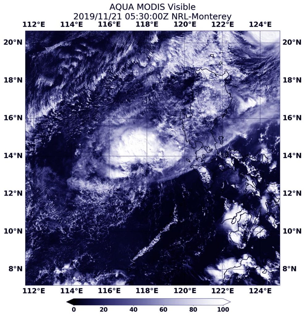
NASA’s Aqua satellite captured an image of Tropical Depression Kalmaegi in the South China Sea as it was dissipating.
Aqua image of Kalmaegi
On Nov. 21, 2019, the MODIS instrument that flies aboard NASA’s Aqua satellite provided a visible image of Tropical Depression Kalmaegi as it was dissipating in the South China Sea. Credit: NASA Worldview

On Nov. 20, Kalmaegi had crossed over Luzon, the northernmost island of the Philippines. The storm then moved into the South China Sea where it encountered stronger wind shear, winds that can tear a storm apart. Kalmaegi is known locally in the Philippines as Tropical Cyclone Ramon.

The Joint Typhoon Warning Center issued the final warning on the storm at 4 p.m. EST (2100 UTC) on Nov. 20. At that time, Kalmaegi was located near latitude 14.1 degrees north and longitude 119.2 degrees east. That is about 109 nautical miles west-southwest of Manila, Philippines. The storm was moving to the southwest, and maximum sustained winds were down to near 75 knots (29 mph/46 kph).

On Nov. 21, the Moderate Imaging Spectroradiometer or MODIS instrument that flies aboard NASA’s Aqua satellite provided a visible image of Kalmaegi. The MODIS image revealed a shapeless storm, indicating that the storm had weakened. Kalmaegi is dissipating over the South China Sea.

NASA’s Aqua satellite is one in a fleet of NASA satellites that provide data for hurricane research.

Typhoons and hurricanes are the most powerful weather event on Earth. NASA’s expertise in space and scientific exploration contributes to essential services provided to the American people by other federal agencies, such as hurricane weather forecasting.

By Rob Gutro
NASA’s Goddard Space Flight Center

Kalmaegi – Northwestern Pacific Ocean

Nov. 20, 2019 – NASA Tracks Typhoon Kalmaegi Affecting Northern Philippines

NASA’s Terra satellite captured an image of Typhoon Kalmaegi as it moved into the Luzon Strait and continued to affect the northern Philippines.

Aqua image of Kalmaegi
On Nov. 19, 2019, the MODIS instrument that flies aboard NASA’s Terra satellite provided a visible image of Typhoon Kalmaegi near the Luzon Strait and northern Philippines. Credit: NASA Worldview

On Nov. 19, Kalmaegi’s western edge was in the Luzon Strait, while its southern quadrant was over the northern Philippines. The Luzon Strait is located between Taiwan and Luzon, Philippines. The strait connects the Philippine Sea to the South China Sea in the northwestern Pacific Ocean.

Kalmaegi is known locally in the Philippines as Tropical Cyclone Ramon, and there are many warning signals in effect for the northern Philippines.

Signal #3 is in effect for the Luzon provinces of Northern portion of Cagayan (Santa Praxedes), Claveria, Sanchez Mira, Pamplona, Abulug, Ballesteros, Aparri, Calayan, Camalaniugan, Buguey, Santa Teresita, Gonzaga and Santa Ana. Signal #2 is in effect for the Luzon provinces of Batanes, Apayao, Kalinga, Abra, Ilocos Norte & Sur and the rest of Cagayan. Signal #1 is in effect for the Luzon provinces of Northern portion of Isabela (Sta. Maria), San Pablo, Maconacon, Cabagan, Sto. Tomas, Quezon, Delfin Albano, Tumauini, Divilacan, Quirino, Roxas, Mallig, San Manuel, Burgos, Gamu and Ilagan City, Mountain Province, Benguet, Ifugao, La Union, and Pangasinan.

On Nov. 19, the Moderate Resolution Imaging Spectroradiometer or MODIS instrument that flies aboard NASA’s Terra satellite provided a visible image of Kalmaegi. The MODIS image showed the hint of an oblong eye covered by high clouds. Forecasters at the Joint Typhoon Warning Center noted that eye had collapsed due to deteriorating environmental conditions.

At 10 a.m. EST (1500 UTC), Typhoon Kalmaegi was located near latitude 19.4 degrees north and longitude 122.5 degrees east. about 301 nautical miles north-northeast of Manila, Philippines. The storm is barely moving, however. It is moving to the west at 1 knot per hour (1 mph/1.8 kph). Maximum sustained winds were near 75 knots (86 mph/139 kph).

Kalmaegi is turning toward a southwesterly course, which will take it across northwestern Luzon (northern Philippines). The storm will start to weaken, then later weaken rapidly, as it moves into the South China Sea.

NASA’s Terra satellite is one in a fleet of NASA satellites that provide data for hurricane research.

Typhoons and hurricanes are the most powerful weather event on Earth. NASA’s expertise in space and scientific exploration contributes to essential services provided to the American people by other federal agencies, such as hurricane weather forecasting.

By Rob Gutro
NASA’s Goddard Space Flight Center

Kalmaegi – Northwestern Pacific Ocean

Nov. 19, 2019 – NASA Tracks Typhoon Kalmaegi Affecting Northern Philippines

NASA’s Terra satellite captured an image of Typhoon Kalmaegi as it moved into the Luzon Strait and continued to affect the northern Philippines.

Suomi NPP image of Kalmaegi
On Nov. 19, 2019, the MODIS instrument that flies aboard NASA’s Terra satellite provided a visible image of Typhoon Kalmaegi near the Luzon Strait and northern Philippines. Credit: NASA Worldview

On Nov. 19, Kalmaegi’s western edge was in the Luzon Strait, while its southern quadrant was over the northern Philippines. The Luzon Strait is located between Taiwan and Luzon, Philippines. The strait connects the Philippine Sea to the South China Sea in the northwestern Pacific Ocean.

Kalmaegi is known locally in the Philippines as Tropical Cyclone Ramon, and there are many warning signals in effect for the northern Philippines.

Signal #3 is in effect for the Luzon provinces of Northern portion of Cagayan (Santa Praxedes), Claveria, Sanchez Mira, Pamplona, Abulug, Ballesteros, Aparri, Calayan, Camalaniugan, Buguey, Santa Teresita, Gonzaga and Santa Ana. Signal #2 is in effect for the Luzon provinces of Batanes, Apayao, Kalinga, Abra, Ilocos Norte & Sur and the rest of Cagayan. Signal #1 is in effect for the Luzon provinces of Northern portion of Isabela (Sta. Maria), San Pablo, Maconacon, Cabagan, Sto. Tomas, Quezon, Delfin Albano, Tumauini, Divilacan, Quirino, Roxas, Mallig, San Manuel, Burgos, Gamu and Ilagan City, Mountain Province, Benguet, Ifugao, La Union, and Pangasinan.

On Nov. 19, the Moderate Resolution Imaging Spectroradiometer or MODIS instrument that flies aboard NASA’s Terra satellite provided a visible image of Kalmaegi. The MODIS image showed the hint of an oblong eye covered by high clouds. Forecasters at the Joint Typhoon Warning Center noted that eye had collapsed due to deteriorating environmental conditions.

At 10 a.m. EST (1500 UTC), Typhoon Kalmaegi was located near latitude 19.4 degrees north and longitude 122.5 degrees east about 301 nautical miles north-northeast of Manila, Philippines. The storm is barely moving, however. It is moving to the west at 1 knot per hour (1 mph/1.8 kph). Maximum sustained winds were near 75 knots (86 mph/139 kph).

Kalmaegi is taking a southwesterly course, which will take it across northwestern Luzon (northern Philippines). The storm will start to weaken, and later rapidly weaken, as it moves into the South China Sea.

NASA’s Terra satellite is one in a fleet of NASA satellites that provide data for hurricane research.

Typhoons and hurricanes are the most powerful weather event on Earth. NASA’s expertise in space and scientific exploration contributes to essential services provided to the American people by other federal agencies, such as hurricane weather forecasting.
By Rob Gutro
NASA’s Goddard Space Flight Center

Kalmaegi – Northwestern Pacific Ocean

Nov. 18, 2019 – NASA Finds Heavy Rain Potential in Typhoon Kalmaegi

NASA analyzed the cloud top temperatures in Typhoon Kalmaegi using infrared light to determine the strength of the storm. Kalmaegi is known locally as Ramon in the Philippines where warnings are in effect.

AIRS image of Kalmaegi
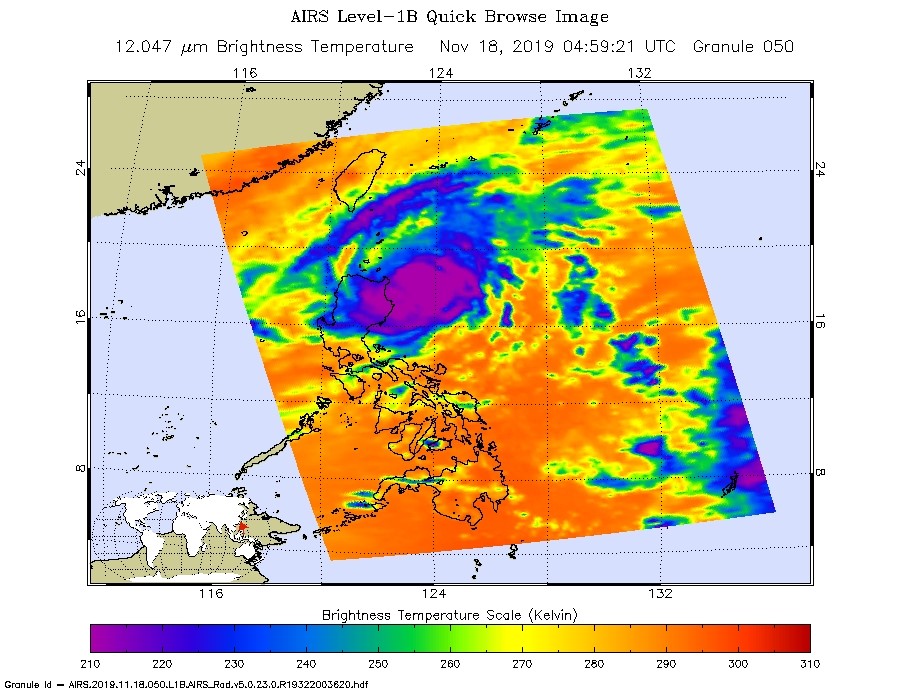
On Nov. 18 at 4:59 UTC (Nov. 17 at 11:59 p.m. EST) NASA’s Aqua satellite analyzed Kalmaegi using the AIRS instrument. AIRS showed the strongest storms with coldest cloud top temperatures (purple) as cold as or colder than 210 Kelvin minus 81 degrees Fahrenheit (minus 63.1 degrees Celsius) around the center and over northeastern Luzon, Philippines. Credit: NASA JPL/Heidar Thrastarson

Kalmaegi has triggered warnings in the Philippines. Philippines tropical cyclone wind signals include Signal #2 for the Luzon provinces of Cagayan (including Babuyan Islands), northern portion of Isabela (Sta Maria), San Pablo, Maconacon, Cabagan, Sto Tomas, Quezon, Delfin Albano, Tumauini and Divilacan, Apayao, Kalinga and Ilocos Norte. In addition, Signal #1 is in effect for the Luzon provinces of Batanes, Ilocos Sur, Abra, Mountain Province, Benguet, Ifugao, La Union, Northern Aurora (Dilasag), Casiguran and Dinalungan and the rest of Isabela.

One of the ways NASA researches tropical cyclones is using infrared data that provides temperature information. Cloud top temperatures identify where the strongest storms are located. The stronger the storms, the higher they extend into the troposphere, and the colder the cloud temperatures.

On Nov. 18 at 4:59 UTC (Nov. 17 at 11:59 p.m. EST) NASA’s Aqua satellite analyzed the storm using the Atmospheric Infrared Sounder or AIRS instrument. The AIRS imagery showed the strongest storms circling the center of circulation, and over the northeastern side of Luzon, northern Philippines. In those areas, AIRS found coldest cloud top temperatures as cold as or colder 210 Kelvin minus 81 degrees Fahrenheit (minus 63.1 degrees Celsius). NASA research has shown that cloud top temperatures that cold indicate strong storms that have the capability to create heavy rain.

Tropical cyclones do not always have uniform strength, and some sides have stronger sides than others, so knowing where the strongest sides of the storms are located helps forecasters. NASA then provides data to tropical cyclone meteorologists so they can incorporate it in their forecasts.

At 10 a.m. EST (1500 UTC) on Nov. 19, the Joint Typhoon Warning Center or JTWC noted that the center of Kalmaegi was located near latitude 18.9 degrees north and longitude 123.0 degrees east. That puts the center about 282 nautical miles north-northeast of Manila, Philippines. Maximum sustained winds were near 75 knots (86 mph/139 kph).

Kalmaegi is turning into a westerly then southwesterly course, rounding the northern areas of Luzon. The storm will start to weaken as it moves southwest into the South China Sea.

Typhoons and hurricanes are the most powerful weather event on Earth. NASA’s expertise in space and scientific exploration contributes to essential services provided to the American people by other federal agencies, such as hurricane weather forecasting.
The AIRS instrument is one of six instruments flying on board NASA’s Aqua satellite which launched on May 4, 2002.

By Rob Gutro
NASA’s Goddard Space Flight Center  

Kalmaegi – Northwestern Pacific Ocean

Nov. 15, 2019 – NASA Looks at Tropical Depression Kalmaegi’s Water Vapor Concentration

When NASA’s Aqua satellite passed over the Philippine Sea, water vapor data provided information about the intensity of Tropical Depression Kalmaegi.

Aqua image of Kalmaegi
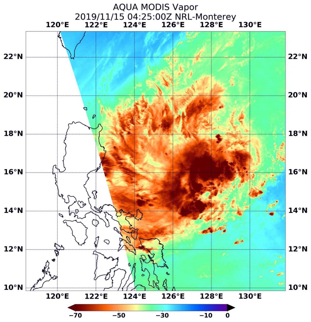
NASA’s Aqua satellite passed over the Philippine Sea and observed Tropical Storm Kalmaegi on Nov. 15 at 0425 UTC (Nov. 14 at 11:25 p.m. EST). The highest concentrations of water vapor (brown) and coldest cloud top temperatures were north and west of the center. Credits: NASA/NRL

NASA’s Aqua satellite passed Kalmaegi on Nov. 15 at 0425 UTC (Nov. 14 at 11:25 p.m. EST) and the Moderate Resolution Imaging Spectroradiometer or MODIS instrument gathered water vapor content and temperature information. The MODIS image showed highest concentrations of water vapor and coldest cloud top temperatures were north and west of the center. MODIS data also showed coldest cloud top temperatures were as cold as or colder than minus 70 degrees Fahrenheit (minus 56.6 degrees Celsius) in those storms. Storms with cloud top temperatures that cold have the capability to produce heavy rainfall.

Water vapor analysis of tropical cyclones tells forecasters how much development potential a storm has. Water vapor releases latent heat as it condenses into liquid. That liquid becomes the clouds and thunderstorms that make up a tropical cyclone. Temperature is important when trying to understand how strong storms can be. The higher the cloud tops, the colder and the stronger they are.

At 10 a.m. EDT (1500 UTC) on Nov. 15, Kalmaegi was located near latitude 15.8 degrees north and longitude 125.9 degrees east. Maximum sustained winds were near 30 knots (34.5 mph/55.5 kph). The depression was moving to the west.

Forecasters at the Joint Typhoon Warning Center expect the storm to strengthen into a tropical storm, make landfall in the northern Philippines and cross into the South China Sea by Nov. 19.

NASA’s Aqua satellite is one in a fleet of NASA satellites that provide data for hurricane research.

Typhoons and hurricanes are the most powerful weather event on Earth. NASA’s expertise in space and scientific exploration contributes to essential services provided to the American people by other federal agencies, such as hurricane weather forecasting.
By Rob Gutro
NASA’s Goddard Space Flight Center

Kalmaegi – Northwestern Pacific Ocean

Nov. 14, 2019 – NASA-NOAA Satellite Finds Displaced Power in Tropical Cyclone Kalmaegi

Tropical Cyclone Kalmaegi is still experiencing wind shear and those winds have continued to displace the strongest storms north of the cyclone’s center. NASA-NOAA’s Suomi NPP satellite passed overhead and identified those strong storms using infrared light.

Suomi NPP image of Kalmaegi
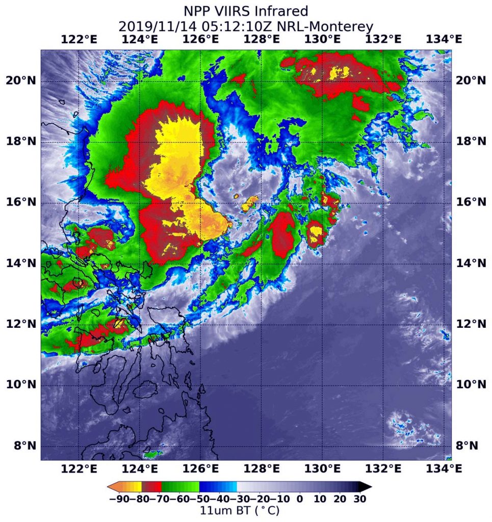
NASA-NOAA’s Suomi NPP satellite passed over Kalmaegi in the Northwestern Pacific Ocean and the VIIRS instrument aboard captured this image of the storm on Nov. 14 at 1:12 a.m. EST (0512 UTC). VIIRS showed strong storms in a large area (yellow/green) north and northwest of the center, where cloud top temperatures were as cold as minus 80 degrees Fahrenheit (minus 62.2 Celsius). Credit: NASA/NRL

The Visible Infrared Imaging Radiometer Suite (VIIRS) instrument aboard Suomi NPP provided an infrared image of the storm. Infrared imagery reveals cloud top temperatures, and the higher the cloud top, the colder it is, and the stronger the storm. The VIIRS instrument aboard captured an infrared image of the storm on Nov. 14 at 1:12 a.m. EST (0512 UTC). VIIRS showed strong storms in a large area north and northwest of the center, where cloud top temperatures were as cold as minus 80 degrees Fahrenheit (minus 62.2 Celsius). Storms with cloud tops that cold have been found to generate heavy rainfall.

Wind shear seems to be preventing Kalmaegi from consolidating, as the storm is still a tropical depression. In general, wind shear is a measure of how the speed and direction of winds change with altitude. Tropical cyclones are like rotating cylinders of winds. Each level needs to be stacked on top each other vertically in order for the storm to maintain strength or intensify. Wind shear occurs when winds at different levels of the atmosphere push against the rotating cylinder of winds, weakening the rotation by pushing it apart at different levels.

At 10 a.m. EDT (1500 UTC), the center of Kalmaegi was located near latitude 15.3 degrees north and longitude 125.8 degrees east. That is 286 nautical miles east of Manila, Philippines.  Maximum sustained winds are near 30 knots (34.5 mph/55.5 kph).

Kalmaegi is moving toward the west-northwest toward a landfall in Luzon, Philippines in the northern part of the country. Landfall is expected in northeastern Luzon on Nov. 16.

Typhoons and hurricanes are the most powerful weather event on Earth. NASA’s expertise in space and scientific exploration contributes to essential services provided to the American people by other federal agencies, such as hurricane weather forecasting.
By Rob Gutro 
NASA’s Goddard Space Flight Center

Kalmaegi – Northwestern Pacific Ocean

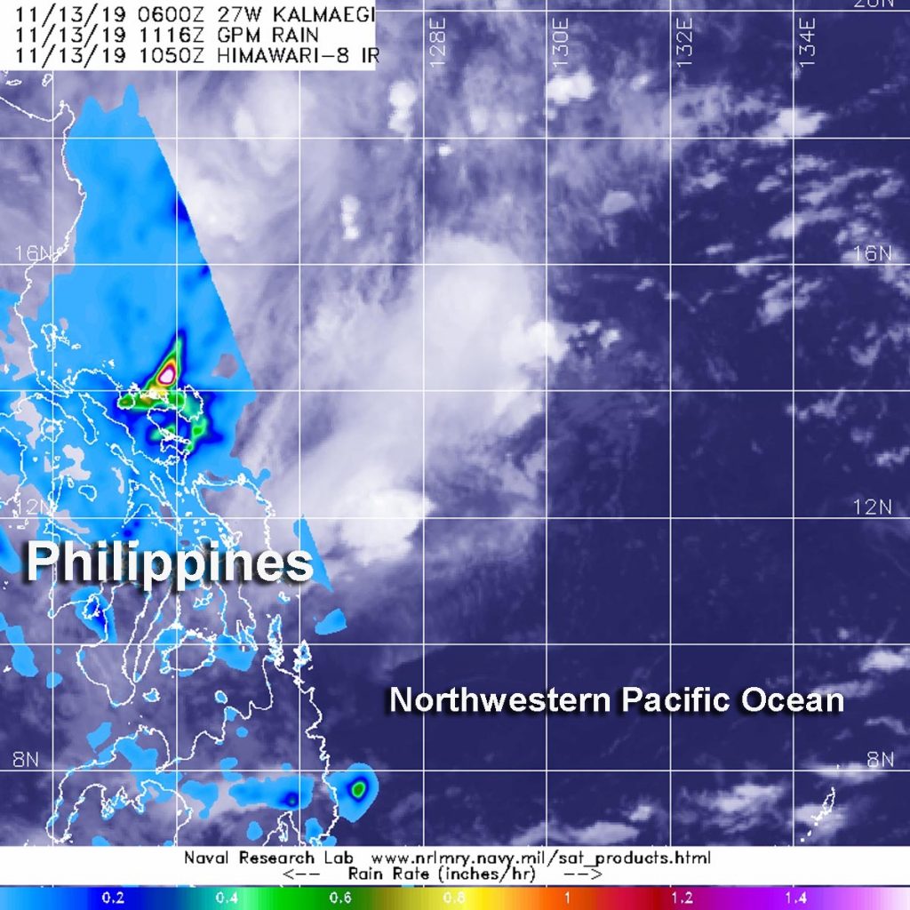
Nov. 13, 2019 – NASA Finds Heavy Rainfall Along Central Philippine Coast from Tropical Depression Kalmaegi

Tropical Depression Kalmaegi continues moving west through the Philippine Sea and toward a landfall in the east central Philippines. NASA provided forecasters with an analysis of rainfall rates occurring in the strengthening tropical cyclone.

GPM image of Kalmaegi
The GPM core satellite passed over strengthening Tropical Depression Kalmaegi in the Philippine Sea, Northwestern Pacific Ocean on Nov. 13 at 6:16 a.m. EST (1116 UTC) and found the heaviest rainfall (pink) near the eastern coast of the Central Philippines, falling at a rate of over 40 mm (about 1.6 inch) per hour. Credit: NASA/JAXA/NRL

NASA has the unique capability of peering under the clouds in storms and measuring the rate at which rain is falling. Global Precipitation Measurement mission or GPM passed over Kalmaegi from its orbit in space and measured rainfall rates throughout the storm.

GPM passed over Kalmaegi in the Philippine Sea, Northwestern Pacific Ocean on Nov. 13 at 6:16 a.m. EST (1116 UTC) and found the heaviest rainfall near the eastern coast of the Central Philippines, falling at a rate of over 40 mm (about 1.6 inch) per hour. Forecasters incorporate the rainfall data into their forecasts. Animated enhanced infrared satellite imagery also shows that it is currently a disorganized system with deep and flaring convection pushed westward from the low-level circulation center which is where GPM found the heaviest rainfall.

At 10 a.m. EST (1500 UTC) on Nov. 13, the Joint Typhoon Warning Center or JTWC noted that Kalmaegi was located near latitude 13.5 degrees north and longitude 128.0 degrees east, about 439 nautical miles east of Manila, Philippines. The depression was moving to the west-northwest and had maximum sustained winds 30 knots (34.5 mph/55.5 kph).

Kalmaegi is moving west and is forecast to start weakening within 24 hours. The storm is then forecast to turn to the west-southwest while slowly weakening as it approaches the Gulf of Aden.

Typhoons and hurricanes are the most powerful weather event on Earth. NASA’s expertise in space and scientific exploration contributes to essential services provided to the American people by other federal agencies, such as hurricane weather forecasting.

Both the Japan Aerospace Exploration Agency, JAXA and NASA manage GPM.

By Rob Gutro
NASA’s Goddard Space Flight Center