Mitag – Northwestern Pacific Ocean

Oct. 03, 2019 – NASA Finds a Transitioning Cyclone Mitag Filling the Sea of Japan

NASA’s Terra satellite passed over the Sea of Japan on Oct. 3 and captured a visible image of Tropical Storm Mitag. Clouds associated with the storm blanketed the Sea of Japan and satellite imagery indicated the storm was becoming extra-tropical.
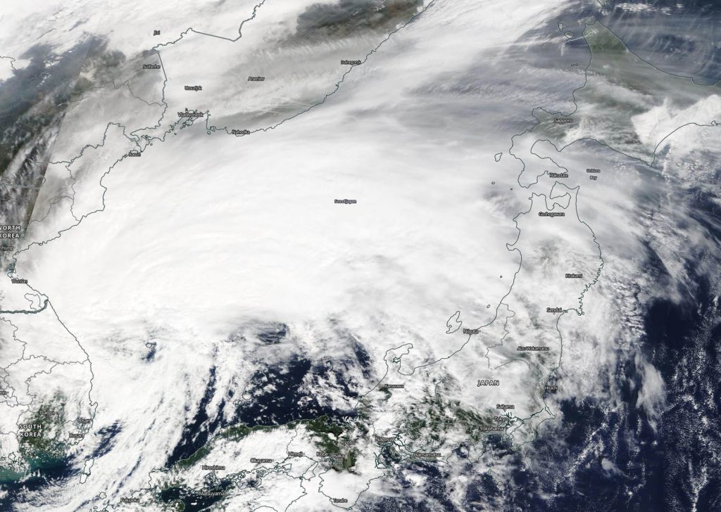
Terra image of Mitag
On Oct. 3, the MODIS instrument that flies aboard NASA’s Terra provided a visible image of Tropical Storm Mitag filling up the Sea of Japan. Credit: NASA Worldview, Earth Observing System Data and Information System (EOSDIS).

On Oct. 3, the Moderate Imaging Spectroradiometer or MODIS instrument that flies aboard NASA’s Terra satellite provided a visible image of Mitag. The MODIS imagery indicated that Mitag had an elongated and poorly defined low level circulation center with the bulk of clouds and convection (rising air that forms the thunderstorms that make up a tropical cyclone) pushed to the northeast of the center as a result of southwesterly wind shear. Sheared convection and initial frontal features indicate that the system is undergoing extratropical transition.

What is Wind Shear?

In general, wind shear is a measure of how the speed and direction of winds change with altitude. Tropical cyclones are like rotating cylinders of winds. Each level needs to be stacked on top each other vertically in order for the storm to maintain strength or intensify. Wind shear occurs when winds at different levels of the atmosphere push against the rotating cylinder of winds, weakening the rotation by pushing it apart at different levels.

What does Extra-tropical Mean?

When a storm becomes extra-tropical it means that a tropical cyclone has lost its “tropical” characteristics. The National Hurricane Center defines “extra-tropical” as a transition that implies both poleward displacement (meaning it moves toward the north or south pole) of the cyclone and the conversion of the cyclone’s primary energy source from the release of latent heat of condensation to baroclinic (the temperature contrast between warm and cold air masses) processes. It is important to note that cyclones can become extratropical and still retain winds of hurricane or tropical storm force.

Mitag’s Final Warning

On Oct. 3 at 5 a.m. EDT (0900 UTC) the Joint Typhoon Warning Center issued the final warning on Tropical Storm Mitag. At that time, Mitag was centered near 38.0 degrees north latitude and 131.8 degrees east longitude. That is about 406 miles west-southwest of Misawa, Japan. Mitag was moving to the northeast and had maximum sustained winds near 40 knots (46 mph/74 kph).

Mitag is moving east-northeast and is expected to make landfall over northern Honshu, Japan, tracking south of Misawa. It is becoming extra-tropical over the Sea of Japan and the extent of the winds (wind field) is expected to become larger after it makes that transition.

Hurricanes are the most powerful weather event on Earth. NASA’s expertise in space and scientific exploration contributes to essential services provided to the American people by other federal agencies, such as hurricane weather forecasting.

By Rob Gutro
NASA’s Goddard Space Flight Center

Mitag – Northwestern Pacific Ocean

Oct. 02, 2019 – NASA Finds Mitag’s Areas of Heavy Rainfall over Korean Peninsula

Tropical Storm Mitag was dropping heavy rainfall along coastal areas of South Korea and lighter rainfall over the entire country.  The Global Precipitation Measurement mission or GPM satellite provided a look at the rainfall occurring from the system.

GPM image of Mitag
The GPM’s core satellite passed over Tropical Storm Mitag on Oct. 2 at 8:46 a.m. EDT (1246 UTC). GPM found heaviest rain (orange) falling in scattered areas over the eastern and southern coasts of South Korea and Sea of Japan. GPM found light rain (light blue) falling over the rest of South Korea at around 0.2 inches (5 millimeters) per hour.  Japan’s Himawari-8 satellite provided the cloud imagery. Credit: NASA/NRL

The GPM’s core satellite passed over Tropical Storm Mitag on Oct. 2 at 8:46 a.m. EDT (1246 UTC). GPM found heaviest rain falling in scattered areas over the eastern and southern coasts of South Korea and over the Sea of Japan. GPM found light rain falling over the rest of South Korea at around 0.2 inches (5 millimeters) per hour.

On Oct. 2 at 11 a.m. EDT (1500 UTC), Mitag was located near latitude 34.4 degrees north and longitude 126.3 degrees west. Mitag was centered about 91 nautical miles south of Kunsan Air Base, South Korea. Maximum sustained winds have decreased to near 40 knots (46 mph/74 kph) and are weakening.

Mitag is moving northeast and is currently over land in South Korea. Forecasters at the Joint Typhoon Warning Center expect that the storm will become extra-tropical in the Sea of Japan.

Typhoons and hurricanes are the most powerful weather event on Earth. NASA’s expertise in space and scientific exploration contributes to essential services provided to the American people by other federal agencies, such as hurricane weather forecasting.
GPM is a joint mission between NASA and the Japan Aerospace Exploration Agency, JAXA.

By Rob Gutro
NASA’s Goddard Space Flight Center

Mitag – Northwestern Pacific Ocean

Oct. 01, 2019 – NASA Satellite Shows Typhoon Mitag’s Large Reach Over East China Sea

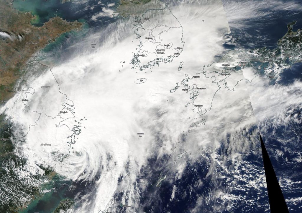
The bulk of Typhoon Mitag’s clouds and precipitation has been pushed north of its center, extending its reach over the East China Sea. Mitag was centered just off the coast of China’s Zhejiang province when NASA-NOAA’s Suomi NPP satellite passed overhead, but the bulk of the clouds were pushed north of center to the Korean Peninsula and southern Japan.

Suomi NPP image of Mitag
NASA-NOAA’s Suomi NPP satellite passed over Typhoon Mitag in the East China Sea just off the coast of China’s Zhejiang province. The image showed Mitag’s northern reach extended to the Korean peninsula and southern Japan. Credit: NASA Worldview, Earth Observing System Data and Information System (EOSDIS)

The Visible Infrared Imaging Radiometer Suite (VIIRS) instrument aboard Suomi NPP provided a visible image of Mitag on Oct. 1, showing its eye was just off the coast of China’s Zhejiang province in the East China Sea. The VIIRS image revealed some bands of thunderstorms wrapped around the partially-exposed, ragged low-level center of circulation off the China coast.

The main area of deep convection (rising air that forms thunderstorms that make up a tropical cyclone) and thunderstorms is located north of center and had decoupled from the center. That decoupled area of storms extended northeast to the Korean Peninsula and to Kyushu, the southwestern most of Japan’s main islands.

Visible imagery from NASA satellites helps forecasters understand if a storm is organizing or weakening. The shape of a tropical cyclone provides forecasters with an idea of its organization and strength. The more circular a storm appears, the stronger it can be. Because the bulk of Mitag’s clouds and showers are pushed north of the center, it appears to be weakening. The image was created by the NASA Worldview Earth Observing System Data and Information System (EOSDIS) at NASA’s Goddard Space Flight Center in Greenbelt, Md.

On Oct. 1, the China Meteorological Administration posted several warnings including Typhoon Warning, and warnings for heavy rain. Those warnings can be found at: http://www.cma.gov.cn/en2014/weather/Warnings/WarningSignals/201409/t20140919_261777.html

At 5 a.m. EDT (0900 UTC) on Oct. 1, Typhoon Mitag had maximum sustained winds near 65 knots (75 mph/120 kph). It was centered near 28.7 degrees north latitude and 122.3 degrees east longitude, about 156 nautical miles south-southeast of Shanghai, China. Mitag is moving north. Forecasters at the Joint Typhoon Warning Center expect Mitag will turn to the northeast and pass over South Korea while weakening. It is expected to become extra-tropical in the Sea of Japan.

Hurricanes are the most powerful weather event on Earth. NASA’s expertise in space and scientific exploration contributes to essential services provided to the American people by other federal agencies, such as hurricane weather forecasting.

By Rob Gutro 
NASA’s Goddard Space Flight Center

Mitag – Northwestern Pacific Ocean

Sep. 30, 2019 – NASA Finds Typhoon Mitag’s Eye East of Taiwan

NASA’s Terra satellite captured an image of Typhoon Mitag’s cloud-filled eye, located east of Taiwan.

Terra image of Mitag
On Sept. 30, the MODIS instrument that flies aboard NASA’s Terra satellite provided a visible image of Typhoon Mitag just east of Taiwan. Credit: NASA Worldview

On Sept. 30, the Moderate Imaging Spectroradiometer or MODIS instrument that flies aboard NASA’s Terra satellite provided a visible image of Mitag. The MODIS image showed the cyclone continues to produce strong thunderstorms around its cloud-filled eye. Mitag’s western quadrant had already spread clouds and precipitation over Taiwan. Powerful bands of thunderstorms were swirling into the low-level center from the eastern side of the storm.

On Sept. 30, warnings remain in effect for the Philippines as Mitag, known locally as Onyok, continues to move north and away from the country. Philippines warnings still in effect include wind signal #1 for the Luzon provinces of Batanes and Babuyan Islands.

At 5 a.m. EDT (0900 UTC), Typhoon Mitag had maximum sustained winds near 75 knots. It was located near 22.8 degrees north latitude and 123.0 degrees east longitude, about 161 nautical miles south-southeast of Taipei, Taiwan.

Mitag is moving north, close to the east coast of Taiwan and forecasters at the Joint Typhoon Warning Center noted that Mitag is at peak intensity. The storm is forecast to graze the east coast of China, south of Shanghai, and then turn northeast.

NASA’s Terra satellite is one in a fleet of NASA satellites that provide data for hurricane research.

Hurricanes are the most powerful weather event on Earth. NASA’s expertise in space and scientific exploration contributes to essential services provided to the American people by other federal agencies, such as hurricane weather forecasting.

For updated forecasts, visit: https://www.nhc.noaa.gov

By Rob Gutro
NASA’s Goddard Space Flight Center

19W – Northwestern Pacific Ocean

Sep. 27, 2019 – NASA-NOAA Satellite Sees Tropical Depression 19W Organizing

NASA-NOAA’s Suomi NPP satellite passed over the Northwestern Pacific Ocean and provided forecasters at the Joint Typhoon Warning Center with a view of Tropical Depression 19W’s structure that helped confirm it is now a depression.

Suomi NPP image of 19W
On Sept. 27, NASA-NOAA’s Suomi NPP satellite passed over newly developed Tropical Depression 19W in the Northwestern Pacific Ocean. The Philippines are seen to the far west of the storm in this image. Credit: NASA/NOAA/NRL

On Sept. 27, 2019, the Visible Infrared Imaging Radiometer Suite (VIIRS) instrument aboard Suomi NPP provided a visible image of newly developed Tropical Depression 19W. The VIIRS image showed the storm had already developed some strong thunderstorms around its center with a band of strong storms feeding into the center from the southeast. The VIIRS imagery helped confirm that the storm is now a depression and appears to be strengthening toward tropical storm status.

On Sept. 27 at 5 a.m. EDT (0900 UTC), Tropical Depression 19W had maximum sustained winds near 25 knots (29 mph)/46 kph). 19W was centered near 14.4 degrees north latitude and 136.2 degrees east longitude. That puts the center approximately 908 nautical miles southeast of Kadena Air Base, Okinawa Island, Japan. The storm was moving to the west.

Forecasters at the Joint Typhoon Warning Center expect 19W will move west-northwest and strengthen, then turn north and move east of Taiwan.

Hurricanes are the most powerful weather event on Earth. NASA’s expertise in space and scientific exploration contributes to essential services provided to the American people by other federal agencies, such as hurricane weather forecasting.

For updated forecasts. Visit: www.nhc.noaa.gov

By Rob Gutro 
NASA’s Goddard Space Flight Center