Nisarga – North Indian Ocean

June 04, 2020 – NASA Finds Nisarga’s Remnants over Central India

Tropical Cyclone Nisarga made landfall in west central India on June 4, and the next day NASA’s Terra satellite provided a look at the remnants of the storm.

Terra image of Nisarga
On June 4, 2020, the MODIS instrument that flies aboard NASA’s Terra satellite provided a visible image of the remnants of Tropical Cyclone Nisarga in central India. Credit: NASA Worldview

On June 4 at 11 a.m. EDT (1500 UTC), the Joint Typhoon Warning Center issued their final warning on Tropical cyclone Nisarga. At that time, Nisarga was located near latitude 19.1 degrees north and longitude 73.7 degrees east, about 48 nautical miles east of Mumbai, India. Nisarga was moving to the north-northeast and still maintained maximum sustained winds 65 knots (75 mph/120 kph). As Nisarga tracked inland to the east of Mumbai the storm weakened from hurricane force to a depression, and finally into a remnant low-pressure area.

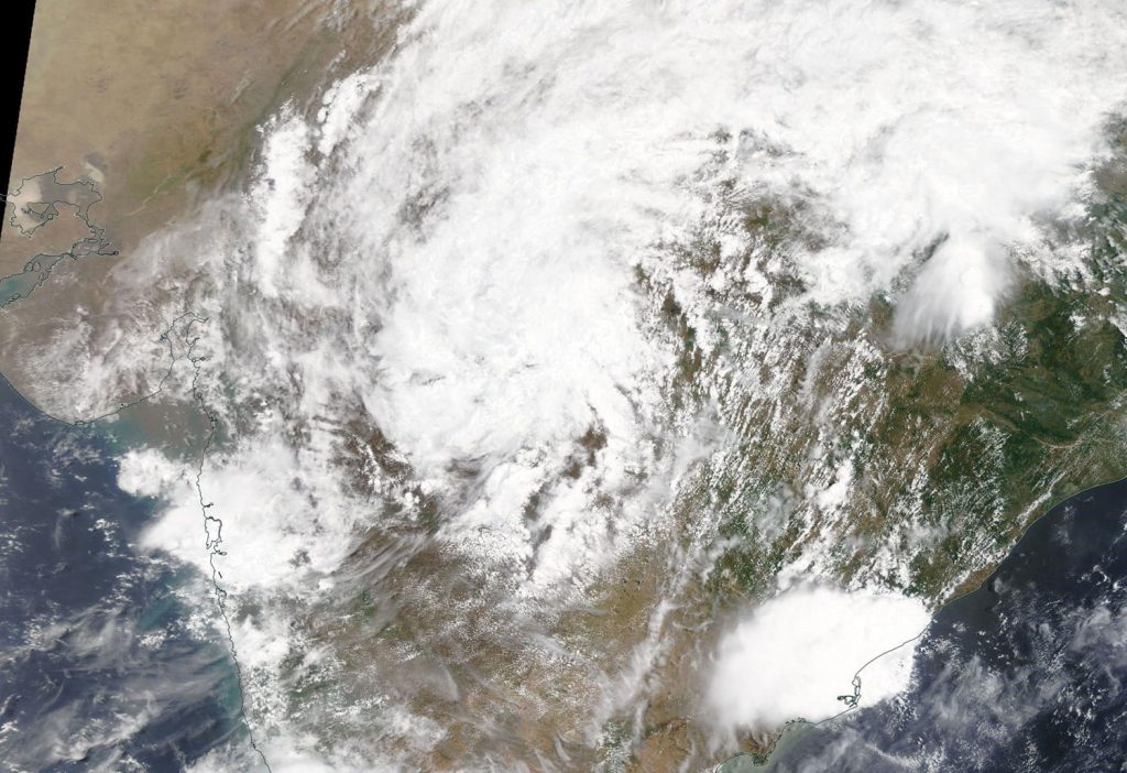
On June 4, the Moderate Resolution Imaging Spectroradiometer or MODIS instrument that flies aboard NASA’s Terra satellite provided a visible image of Nisarga’s remnant clouds, now located over central India.

At 1130 IST (2 a.m. EDT), India’s Regional Specialized Meteorological Centre (RSMC) noted that the remnants of Nisarga was located over south Madhya Pradesh state and adjoining Vidarbha state near latitude 21.8 degrees north and longitude 77.6 degrees east, about 87 miles (140 km) north-northeast of Akola (Maharashtra) and 99 miles (160 km) south-southeast of Bhopal (Madhya Pradesh).

RSMC noted, “Light to moderate rainfall at most places with heavy to very heavy falls at isolated places very likely over east Madhya Pradesh and Chhattisgarh. Light to moderate rainfall at most places with heavy falls at isolated places very likely over Vidarbha and west Madhya Pradesh during next 24 hours.”

RSMC forecasters said the remnants are likely to move northeastward and weaken into a low-pressure area by the evening hours.

NASA’s Terra satellite is one in a fleet of NASA satellites that provide data for hurricane research.

Tropical cyclones/hurricanes are the most powerful weather events on Earth. NASA’s expertise in space and scientific exploration contributes to essential services provided to the American people by other federal agencies, such as hurricane weather forecasting.

By Rob Gutro
NASA’s Goddard Space Flight Center

Nisarga – North Indian Ocean

June 03, 2020 – NASA Infrared Data Shows Tropical Cyclone Nisarga Strengthened Before Landfall

Satellite data of Tropical Cyclone Nisarga’s cloud top temperatures revealed that the storm had strengthened before it began making landfall in west central India.

AIRS image of Nisarga
On June 2 at 4:47 p.m. EDT (2047 UTC) NASA’s Aqua satellite analyzed Tropical Cyclone Nisarga using the Atmospheric Infrared Sounder or AIRS instrument. AIRS found coldest cloud top temperatures as cold as or colder than (purple) minus 63 degrees Fahrenheit (minus 53 degrees Celsius) around the storm’s center. Credit: NASA JPL/Heidar Thrastarson

Nisarga formed around 5 p.m. EDT (2100 UTC) on June 2, and had maximum sustained winds near 40 knots (46 mph/74 kph) at that time. Within 12 hours, the storm intensified to hurricane strength.

One of the ways NASA researches tropical cyclones is using infrared data that provides temperature information. Cloud top temperatures provide information to forecasters about where the strongest storms are located within a tropical cyclone (which are made of hundreds of thunderstorms). Tropical cyclones do not always have uniform strength, and some sides are stronger than others. The stronger the storms, the higher they extend into the troposphere, and the colder the cloud temperatures.

On June 2 at 4:47 p.m. EDT (2047 UTC) NASA’s Aqua satellite analyzed the storm using the Atmospheric Infrared Sounder or AIRS instrument. AIRS found cloud top temperatures were getting colder. Colder cloud tops are an indication that the uplift of air in the storm was getting stronger and thunderstorms were building higher into the troposphere. AIRS found temperatures as cold as or colder than minus 63 degrees Fahrenheit (minus 53 degrees Celsius) around the center. NASA research has shown that cloud top temperatures that cold indicate strong storms that have the capability to create heavy rain.

The Joint Typhoon Warning Center noted at 5 a.m. EDT (0900 UTC), Tropical cyclone Nisarga was located near latitude 17.9 degrees north and longitude 72.9 degrees east, about 65 nautical miles (75 miles/120 km) south of Mumbai, India. The storm was moving to the northeast.

Maximum sustained winds were near 75 knots (86 mph/139 kph) making it a Category 1 hurricane on the Saffir-Simpson Hurricane Wind Scale. Those hurricane force winds extended 25 miles (40 km) from the center, while tropical-storm force winds extended 75 miles from the center.

At that time, Nisarga was making landfall south of Mumbai. The system is forecast to track inland and dissipate.

Typhoons and hurricanes are the most powerful weather events on Earth. NASA’s expertise in space and scientific exploration contributes to essential services provided to the American people by other federal agencies, such as hurricane weather forecasting.

The AIRS instrument is one of six instruments flying on board NASA’s Aqua satellite, launched on May 4, 2002.

By Rob Gutro
NASA’s Goddard Space Flight Center