Noul – Northwestern Pacific Ocean

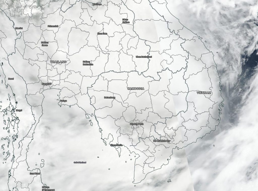
Sep. 18, 2020 – NASA-NOAA’s Suomi NPP Satellite Finds Tropical Storm Noul Fading over Laos

Tropical Storm Noul made landfall in central Vietnam on Sept. 17 and NASA-NOAA’s Suomi NPP satellite captured an image of the storm over Laos. Noul was weakening as it moves toward Thailand where it is forecast to dissipate.

Suomi NPP image of Noul
NASA-NOAA’s Suomi NPP satellite provided forecasters with a visible image of Tropical Storm Noul over Laos on Sept. 18. It is expected to dissipate over Thailand in a day. Credit: NASA Worldview, Earth Observing System Data and Information System (EOSDIS)

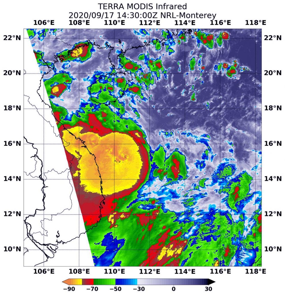
The Joint Typhoon Warning Center (JTWC) reported that the system made landfall just north of Hue, Vietnam at about 0100 UTC on Sept. 18 (9 p.m. EDT on Sept. 17) and had begun to track inland.

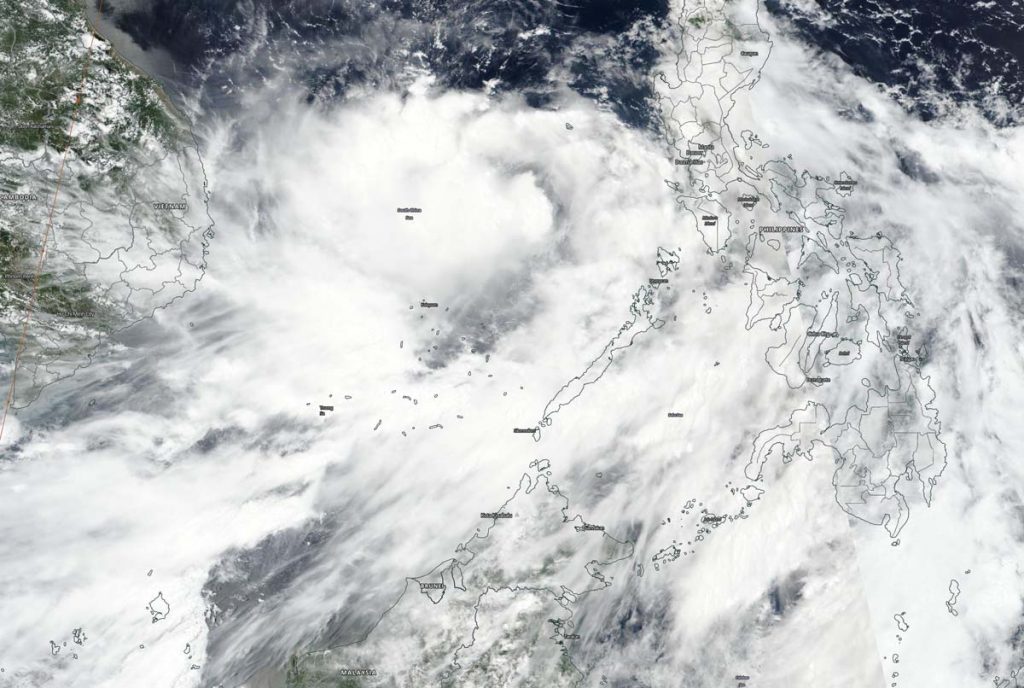
On Sept. 18 at 3 a.m. EDT (0700 UTC/2 p.m. Vietnam local time), the VIIRS instrument aboard the Suomi NPP satellite provided a visible image of Noul as it moved into Thailand. The storm appeared shapeless and the low-level center was difficult to find. Deep convection is obscuring the low-level circulation center which has tracked inland and is located over Laos.

By 5 a.m. EDT (0900 UTC), JTWC issued the final bulletin on the storm. At that time, Tropical storm Noul was located near latitude 16.4 degrees north and longitude 104.4 degrees east, about 174 nautical miles west of Da Nang, Vietnam and over Laos. It was moving to the west and had maximum sustained winds 40 knots (46 mph/74 kph).

Noul is now dissipating as it moves toward Thailand.

NASA Researches Tropical Cyclones

Hurricanes/tropical cyclones are the most powerful weather events on Earth. NASA’s expertise in space and scientific exploration contributes to essential services provided to the American people by other federal agencies, such as hurricane weather forecasting.

For more than five decades, NASA has used the vantage point of space to understand and explore our home planet, improve lives and safeguard our future. NASA brings together technology, science, and unique global Earth observations to provide societal benefits and strengthen our nation. Advancing knowledge of our home planet contributes directly to America’s leadership in space and scientific exploration.

By Rob Gutro 
NASA’s Goddard Space Flight Center

Noul – Northwestern Pacific Ocean

Sep. 17, 2020 – NASA Finds Tropical Storm Noul Packing a Punch    

Powerful storms with heavy rainmaking capabilities appeared over the coast of central Vietnam in NASA provided infrared imagery on Sept. 17.

Terra image of Noul
On Sept. 17 at 10:30 a.m. EDT (1430 UTC) the MODIS instrument that flies aboard NASA’s Aqua satellite revealed a large area of the most powerful thunderstorms (yellow) were around Noul’s center where cloud top temperatures were as cold as minus 80 degrees Fahrenheit (minus 62.2 Celsius). Those storms were over the central Vietnam coast and extended over the South China Sea. Strong storms (red) with cloud top temperatures as cold as minus 70 degrees Fahrenheit (minus 56.6. degrees Celsius) surrounded the center and were generating large amounts of rain. Credit: NASA/NRL

NASA’s Infrared Data Reveals Heavy Rainmakers

Tropical cyclones are made up of hundreds of thunderstorms, and infrared data can show where the strongest storms are located. That is because infrared data provides temperature information, and the strongest thunderstorms that reach highest into the atmosphere have the coldest cloud top temperatures.

On Sept. 17 at 10:30 a.m. EDT (1430 UTC), the Moderate Imaging Spectroradiometer or MODIS instrument that flies aboard NASA’s Aqua satellite revealed a large area of the most powerful thunderstorms (yellow) were around Noul’s center where cloud top temperatures were as cold as minus 80 degrees Fahrenheit (minus 62.2 Celsius). Those storms were mostly in the western quadrant of the storm and over the central Vietnam coast and they extended over the South China Sea. Strong storms with cloud top temperatures as cold as minus 70 degrees Fahrenheit (minus 56.6. degrees Celsius) surrounded the center and were generating large amounts of rain.

Noul was encountering some northeasterly vertical wind shear. That is, outside winds blowing from the northeast and pushing the bulk of clouds and precipitation toward the southwest of the center of circulation.

National Centre for Hydro-Meteorological Forecasting (NCHMF) is a governmental organization belonging Vietnam Meteorological Hydrological Administration (VMHA). NCHMF has authority to issue forecasting/warning information for weather, climate, hydrology, water resource, marine weather (i.e. hydrometeorology) and provide hydrometeorology services. NHCMF has issued coastal warnings for central Vietnam. Those warnings can be found on their website: https://nchmf.gov.vn/KttvsiteE/en-US/2/index.html.

Noul’s Status on Sept. 17

At 11 a.m. EDT (1500 UTC), Noul had maximum sustained winds near 45 knots. It was located over the coastline of central Vietnam, near latitude 15.9 degrees north and longitude 110.9 degrees east, about 191 nautical miles east of Da Nang, Vietnam.  Noul was moving to the west and is forecast to move across Laos and Thailand over the next couple of days as it weakens due to interaction with land.

NASA Researches Earth from Space

For more than five decades, NASA has used the vantage point of space to understand and explore our home planet, improve lives and safeguard our future. NASA brings together technology, science, and unique global Earth observations to provide societal benefits and strengthen our nation. Advancing knowledge of our home planet contributes directly to America’s leadership in space and scientific exploration.

By Rob Gutro 
NASA’s Goddard Space Flight Center

Noul – Northwestern Pacific Ocean

Sep. 16, 2020 – NASA-NOAA Satellite Finds a Strengthening Tropical Storm Noul

NASA-NOAA’s Suomi NPP satellite passed over the South China Sea and captured a visible image of Tropical Storm Noul as it continued to organize and intensify.

Suomi NPP image of Noul
On Sept. 16, NASA-NOAA’s Suomi NPP satellite passed over the South China Sea and captured a visible image of Tropical storm Noul as it continued to strengthen. Credit: NASA Worldview, Earth Observing System Data and Information System (EOSDIS).

Noul formed from a low-pressure area that began on the eastern side of the Philippines. The low crossed the Philippines and developed into Tropical Depression 13W in the Sulu Sea. The depression intensified, consolidated and became a tropical storm renamed Noul.

The Visible Infrared Imaging Radiometer Suite (VIIRS) instrument aboard Suomi NPP provided a visible image of Noul on Sept. 16. The VIIRS imagery and animated enhanced infrared satellite imagery shows building convection and clouds obscuring a partially exposed low-level circulation center. The image also showed some banding of thunderstorms.

At 11 a.m. EDT (1500 UTC) on Sept. 16, the Joint Typhoon Warning Center noted that Tropical storm Noul was located near  latitude 13.7 degrees north and longitude 115.6 degrees east. That is about 445 nautical miles east-southeast of Da Nang, Vietnam. Noul is moving to the west-northwest and had maximum sustained winds near 45 knots (52 mph/83 kph). The storm was strengthening in the warm waters of the South China Sea.

Noul is forecast to move west-northwest across the South China Sea. The storm will strengthen to 65 knots (75 mph), just attaining typhoon strength prior to landfall in central Vietnam in one and a half days.

For more than five decades, NASA has used the vantage point of space to understand and explore our home planet, improve lives and safeguard our future. NASA brings together technology, science, and unique global Earth observations to provide societal benefits and strengthen our nation. Advancing knowledge of our home planet contributes directly to America’s leadership in space and scientific exploration.

For updated forecasts, visit: www.nhc.noaa.gov

By Rob Gutro  
NASA’s Goddard Space Flight Center