Sep. 14, 2018 – NASA Sees Wind Shear Bringing Post-tropical Cyclone Olivia Toward Dissipation
NASA-NOAA’s Suomi NPP satellite found that as Post-tropical cyclone Olivia was being strongly affected by wind shear in the Central Pacific Ocean. That shear was preventing the development of the thunderstorms that would revive the storm, so it weakened into a post-tropical system and is expected to dissipate over the weekend of Sept. 15.
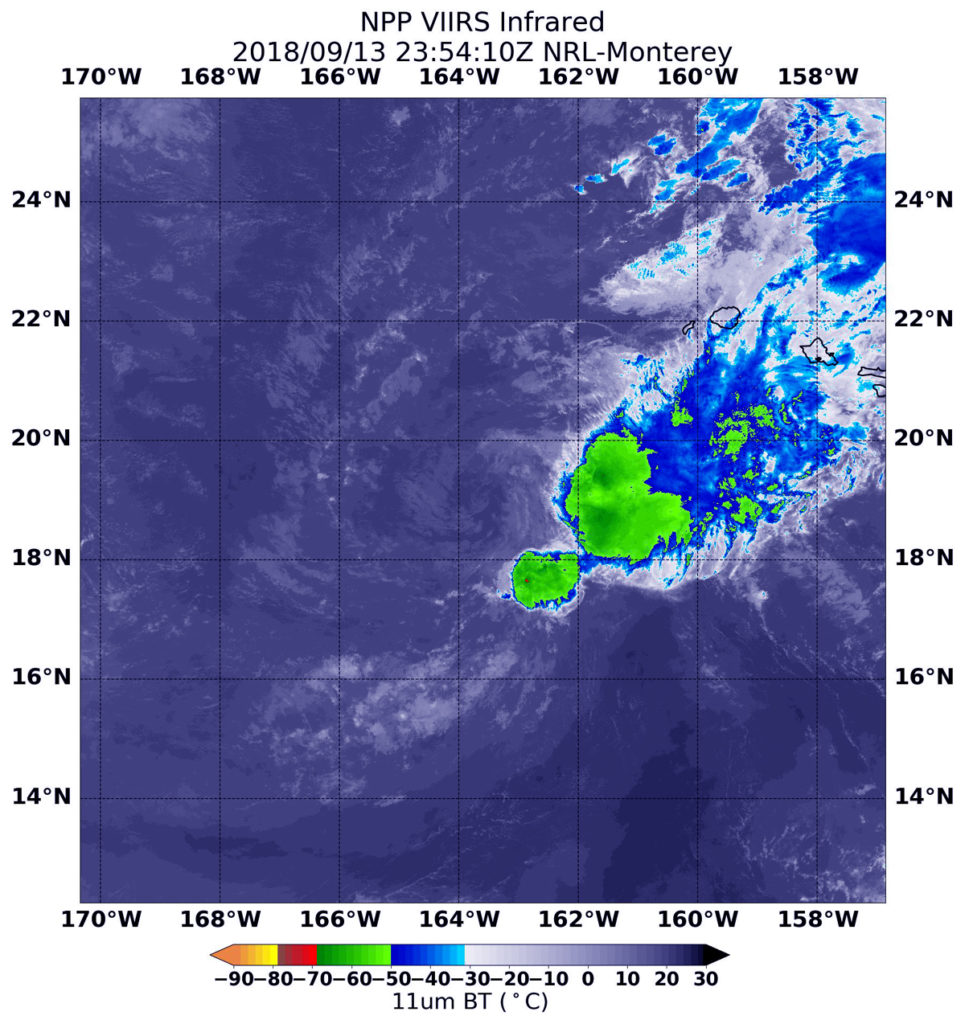
Infrared imagery on Sept. 13 at 7:54 p.m. EDT (2354 UTC) from the Visible Infrared Imaging Radiometer Suite (VIIRS) instrument aboard NASA-NOAA’s Suomi NPP satellite showed that Tropical Depression Olivia was being affected by westerly wind shear that was pushing the bulk of its clouds east of center. In general, wind shear is a measure of how the speed and direction of winds change with altitude. Wind shear can tear a tropical cyclone apart or weaken it.
At 11 a.m. EDT (5 a.m. HST/1500 UTC) the Central Pacific Hurricane Center issued their final advisory on Olivia. At that time the center of Post-Tropical Cyclone Olivia was located near latitude 18.9 degrees north and longitude 164.2 degrees west. The
post-tropical cyclone is moving toward the west near 15 mph (24 km/h). This motion will continue into Friday, followed by a turn toward the west-northwest on Saturday.
Maximum sustained winds are near 35 mph (55 kph) with higher gusts.
Weakening is forecast, with dissipation expected by Sunday.
By Rob Gutro
NASA’s Goddard Space Flight Center
Sep. 13, 2018 – NASA Sees Tropical Depression Olivia’s Strength Waning
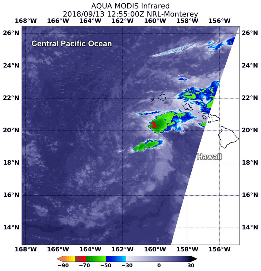
NASA’s Aqua satellite provided an infrared look at a weakening and now tropical depression Olivia in the Central Pacific Ocean. Olivia soaked the Hawaiian Islands on its east to west track through them.
The Central Pacific Hurricane Center or CPHC noted now that Olivia’s center has moved west of the Hawaiian Islands, as such there are no coastal watches or warnings in effect. However, interests in the northwest Hawaiian Islands should monitor the progress of Olivia.
On Sept. 13, Olivia was moving rapidly toward the west-southwest, far southwest of Hawaii, however, flooding rainfall continues across parts of the main Hawaiian Islands.
At 2:20 a.m. EDT (0230 UTC) on Sept. 13, Moderate Resolution Imagine Spectroradiometer or MODIS instrument aboard NASA’s Aqua satellite analyzed Tropical Depression Olivia in infrared light. MODIS found coldest cloud top temperatures in powerful storms with cloud tops as cold as or colder than minus 70F (minus 56.6C) west of the Hawaiian Islands. NASA research has found that cloud top temperatures as cold as or colder than the 70F/56.6C threshold have the capability to generate heavy rainfall.
Despite the heaviest rainfall off-shore, the CPHC noted scattered thunderstorms continue to develop far northeast, southeast, and south of the low-level circulation center, but the core of the system remains completely devoid of deep convection (developing strong thunderstorms).
The CHPC forecast said “Lingering moisture from Olivia continues to cause heavy rainfall across portions of the main Hawaiian Islands this morning. These wet conditions will likely persist through tonight. Since many areas are already saturated, any additional heavy rainfall could produce life-threatening flash flooding.”
Olivia is being weakened by southwesterly vertical wind shear of over 30 knots (34.5 mph/55.5 kph). In general, wind shear is a measure of how the speed and direction of winds change with altitude. Wind shear can tear a tropical cyclone weaken it or even tear it apart.
At 11 a.m. EDT (5 a.m. HST/1500 UTC), the center of Tropical Depression Olivia was located near latitude 19.5 degrees north and longitude 162.2 degrees west. That’s about 250 miles (400 km) southwest of Lihue, Hawaii.
CPHC said the depression is moving toward the west-southwest near 18 mph (30 kph), and this general motion is expected to continue through this morning with a slight decrease in forward speed, followed by a turn toward the west later today. Olivia, or its remnant low, is forecast to turn toward the west-northwest later tonight or Friday.
Maximum sustained winds are near 35 mph (55 kph) with higher gusts. Little change in strength is forecast through tonight. Olivia is expected to become a post-tropical remnant low by Friday.
For updated forecasts on Olivia, visit: http://www.prh.noaa.gov/cphc
By Rob Gutro
NASA Goddard Space Flight Center
Sep. 12, 2018 – NASA Sees Hawaii Facing Tropical Storm Olivia
While the U.S. East Coast prepares for Hurricane Florence, the U.S. state of Hawaii is feeling the effects of Tropical Storm Olivia. NASA’s Aqua satellite provided an infrared look at Olivia that showed wind shear was affecting it before landfall.
On Sept. 12, a Tropical Storm Warning is in effect for Oahu, Maui County including the islands of Maui, Molokai, Lanai, and Kahoolawe. Interests in the Northwest Hawaiian Islands should monitor the progress of Olivia.
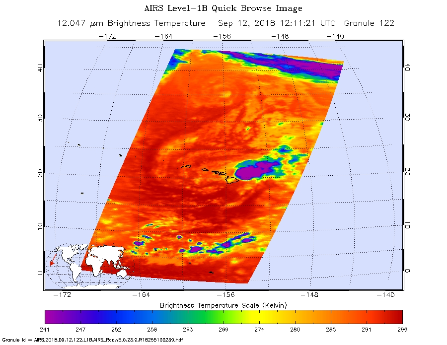
When NASA’s Aqua satellite passed over Tropical Storm Olivia on Sept. 12 at 8:11 a.m. EDT (1211 UTC) was closing in on landfall in Hawaii. The Atmospheric Infrared Sounder or AIRS instrument analyzed the storm in infrared light which provides temperature information. Temperature is important when trying to understand how strong storms can be. The higher the cloud tops, the colder and the stronger they are.
Vertical wind shear was affecting Olivia and pushing storms east of its center. In general, wind shear is a measure of how the speed and direction of winds change with altitude. Wind shear can tear a tropical cyclone apart or weaken it.
AIRS saw coldest cloud top temperatures were as cold as minus 63 degrees Fahrenheit (minus 53 degrees Celsius) pushed east of the center. Storms with cloud top temperatures that cold have the capability to produce heavy rainfall.
That rainfall is affecting Hawaii today, Sept. 12. The CPHC said “Showers will continue to increase over the main Hawaiian Islands today. Olivia is expected to produce total rainfall accumulations of 5 to 10 inches in some areas, with isolated maximum amounts of 15 inches possible, especially in higher terrain. This rainfall may produce life-threatening flash flooding. Up to 6 inches of rain has already fallen over parts of Maui.”
At 11 a.m. EDT (5 a.m. HST/1500 UTC), the center of Tropical Storm Olivia was located near latitude 21.2 degrees north, longitude 155.7 degrees west. That’s about 55 miles (90 km) east-northeast of Kahului Hawaii. Olivia is moving toward the west near 12 mph (19 km/h), and this motion is expected to continue through this morning. A motion toward the west-southwest is expected later today, with an increase in forward speed. This general motion is then expected to continue the next couple of days.
Maximum sustained winds are near 45 mph (75 kph) with higher gusts. Some weakening is forecast during the next 48 hours.
For updated forecasts, visit: http://www.prh.noaa.gov/cphc
By Rob Gutro
NASA’s Goddard Space Flight Center
Sep. 11, 2018 – NASA Sees Hurricane Olivia Moving Toward Hawaii
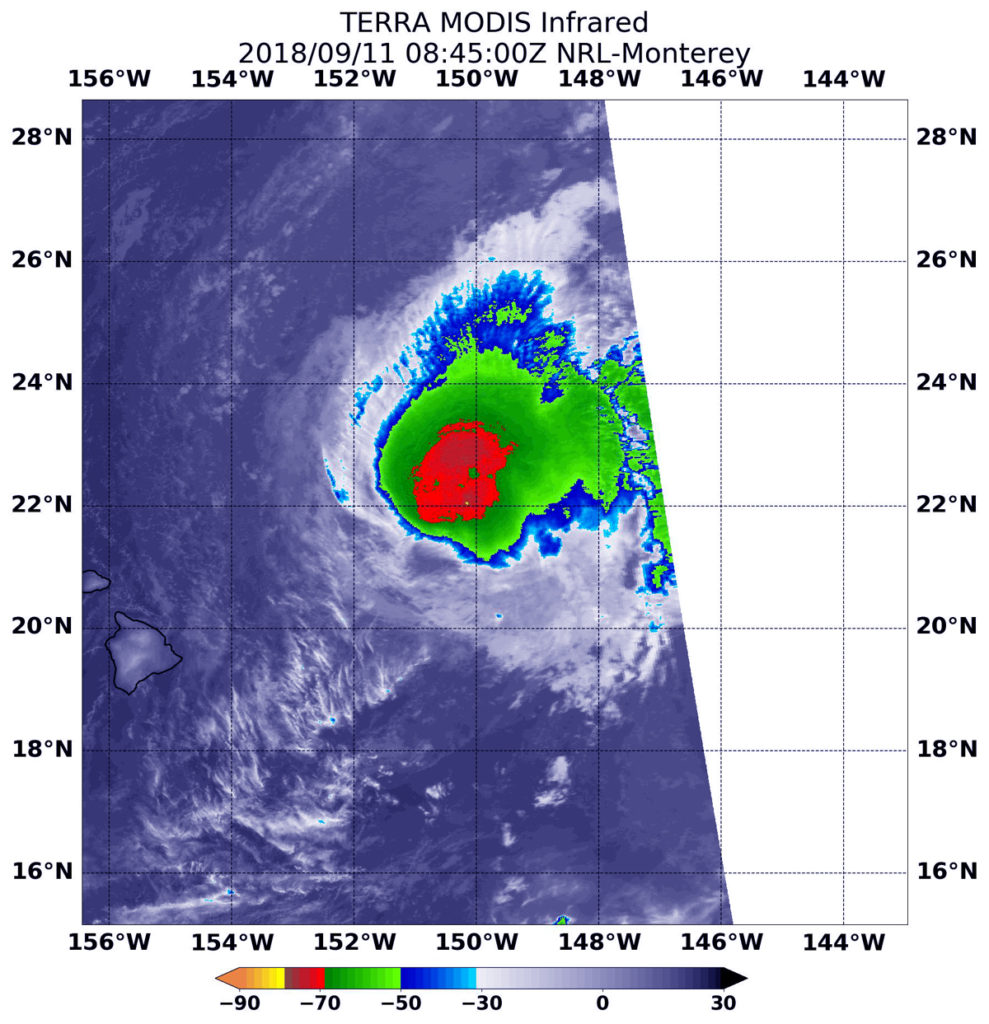
NASA’s Terra satellite provided an inside look at Hurricane Olivia as it continued to track toward Hawaii. Watches and Warnings remain in effect as Olivia nears.
A Tropical Storm Warning is in effect for. Oahu, Maui County…including the islands of Maui, Molokai, Lanai, and, Kahoolawe, and Hawaii County. A Tropical Storm Watch is in effect for Kauai County…including the islands of Kauai and Niihau.
At 4:45 a.m. EDT (0845 UTC) on Sept. 11, from the Moderate Resolution Imaging Spectroradiometer or MODIS instrument aboard NASA’s Terra satellite revealed strongest storms in Olivia had cloud tops with temperatures near minus 70 degrees Fahrenheit (minus 56.6 degrees Celsius). NASA research has found that cloud top temperatures that cold have the capability to generate heavy rainfall.
NOAA’s Central Pacific Hurricane Center (CPHC) said “Hurricane Hunters from the 53rd Weather Reconnaissance Squadron found Olivia’s low-level center further east than anticipated. Some conflicting data exists as to the current intensity, as the central pressure has risen, but winds in the northwest quadrant were stronger than earlier today.”
At 8 a.m. EDT (2 a.m. HST/1200 UTC), the center of Tropical Storm Olivia was located near latitude 21.9 degrees north and longitude 150.7 degrees west. That’s about 320 miles (515 km) east-northeast of Hilo, Hawaii.
Maximum sustained winds are near 65 mph (100 kph) with higher gusts. Gradual weakening is forecast during the next 48 hours, but Olivia is expected to remain a tropical storm as it moves over the islands.
Olivia is moving toward the west near 10 mph (17 kph). A turn to the west-southwest is expected later today, with this general motion continuing for the next couple of days. On the forecast track, the center of Olivia will be moving over portions of the main Hawaiian Islands late tonight into Wednesday, Sept. 12.
For updated forecasts, visit: http://www.prh.noaa.gov/cphc
By Rob Gutro
NASA’ Goddard Space Flight Center
Sep. 10, 2018 – NASA Tracking Hurricane Olivia’s Track toward Hawaii
Hurricane Olivia moved from the Eastern Pacific into the Central Pacific and is expected to affect Hawaii. NASA’s Aqua satellite the northeast and southwestern quadrants of the storm to be the most powerful on Sept. 10.
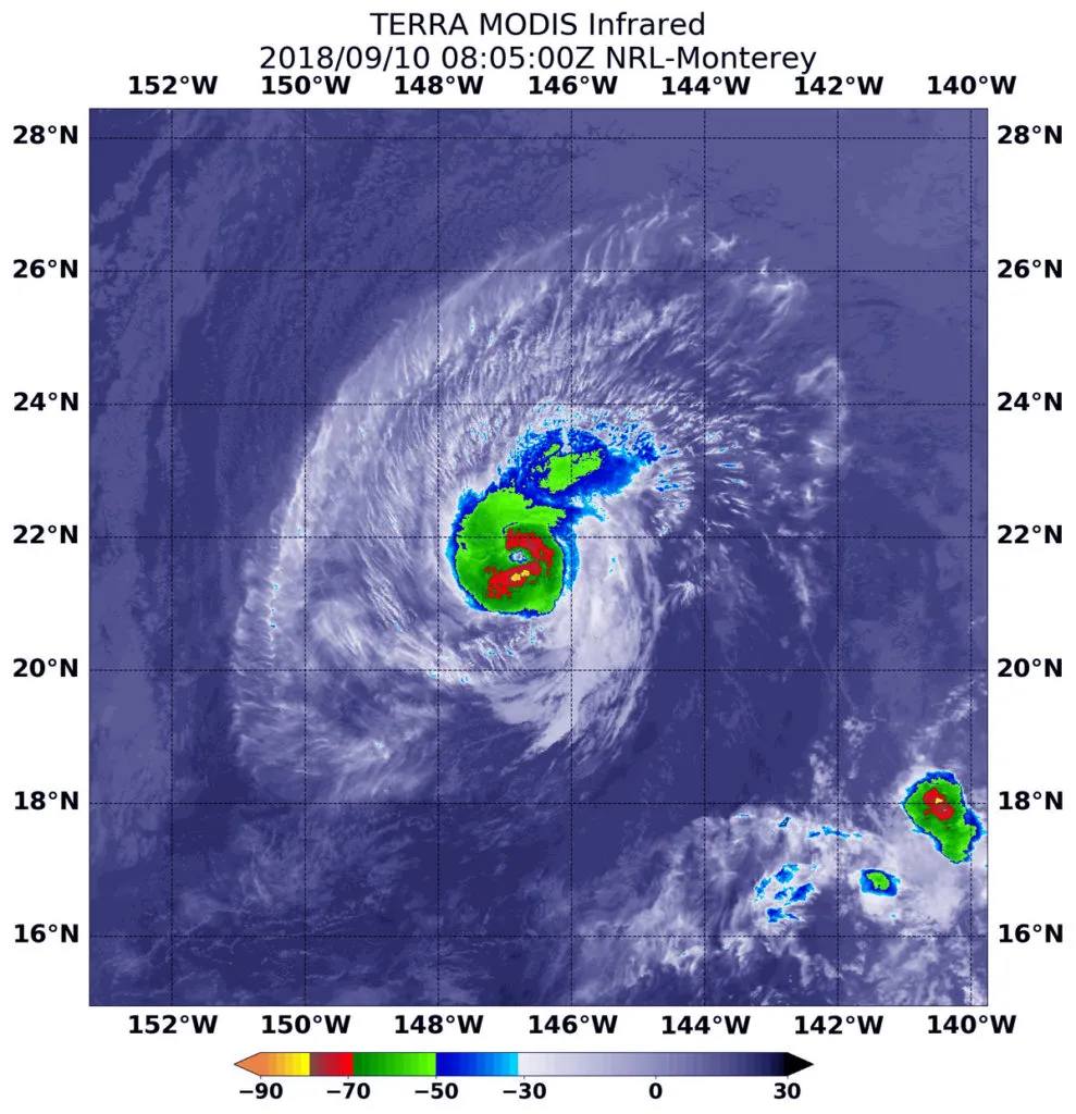
Infrared satellite data at 12:15 a.m. EDT (0415 UTC) on Sept. 10 from the Moderate Resolution Imaging Spectroradiometer or MODIS instrument aboard NASA’s Aqua satellite revealed the strongest storms were southwest and northeast of the center. In those areas MODIS found coldest cloud tops had temperatures near minus 70 degrees Fahrenheit (minus 56.6 degrees Celsius). NASA research has found that cloud top temperatures that cold have the capability to generate heavy rainfall.
The MODIS data showed that the strongest storms only extended out 30 miles from the center. Hurricane-force winds extend outward up to 30 miles (45 km) from the center and tropical-storm-force winds extend outward up to 115 miles (185 km).
The Central Pacific Hurricane Center of CPHC noted a Tropical Storm Warning is in effect for Hawaii that covers Maui County, including the islands of Maui, Molokai, Lanai, and Kahoolawe and Hawaii County. A Tropical Storm Watch is in effect for Oahu.
At 11 a.m. EDT (1500 UTC/5 a.m. HST), the center of Hurricane Olivia was located near latitude 21.7 degrees north and longitude 148.0 degrees west. Maximum sustained winds are near 85 mph (140 kph) with higher gusts. Little change in strength is forecast today, with slight weakening starting tonight and continuing through Tuesday. However, Olivia is forecast to be a strong tropical storm when it reaches the Hawaiian Islands.
Olivia is moving toward the west near 10 mph (17 kph). This general motion is expected to continue early today, followed by a turn toward the west-southwest starting later today. This west-southwest motion is expected to continue through Tuesday night. On this forecast track, tropical storm conditions are expected over parts of Hawaii starting late Tuesday.
For updates on Olivia, visit: http://www.prh.noaa.gov/cphc
By Rob Gutro
NASA’s Goddard Space Flight Center
Sep. 07, 2018 – Hurricane Olivia’s Eye Obvious from NASA’s Aqua Satellite
Hurricane Olivia’s eye was clear in infrared imagery taken by NASA’s Aqua satellite from its orbit in space.
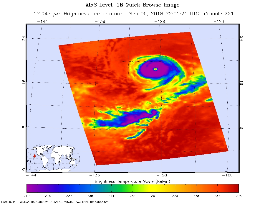
Infrared satellite data at 4:50 p.m. EDT (2205 UTC) on Sept. 6, from the instrument aboard NASA’s Aqua satellite showed a clear image of Hurricane Olivia’s eye surrounded by coldest cloud top temperatures near minus 63 degrees Fahrenheit (minus 53 degrees Celsius). NASA research has found that cloud top temperatures that cold have the capability to generate heavy rainfall.
On Sept.7, Olivia’s overall cloud structure in infrared and passive microwave satellite imagery has changed little since the previous advisory, except that the cloud tops have warmed significantly around the well-defined, 20-nautical-mile in diameter eye.
At 5 a.m. EDT (0900 UTC) on Sept. 7 the National Hurricane Center or NHC noted the center of Hurricane Olivia was located near latitude 19.6 degrees north and longitude 131.2 degrees west.
Olivia is moving toward the west-northwest near 15 mph (24 kph), and this general motion is forecast to continue through Saturday. A gradual turn toward the west is expected Saturday night or Sunday. Maximum sustained winds have decreased to near 125 mph (205 kph) with higher gusts. Olivia is a category 3 hurricane on the Saffir-Simpson Hurricane Wind Scale.
NHC said “A slow weakening trend is expected through the weekend.”
For updates on Olivia, visit: www.nhc.noaa.gov
By Rob Gutro
NASA’s Goddard Space Flight Center
Sep. 06, 2018 – NASA’s GPM Finds Heavy Rain Rings Category 3 Hurricane Olivia’s Eye
The Global Precipitation Measurement mission or GPM satellite passed over Hurricane Olivia and found heaviest rain in a tight ring around the eye.
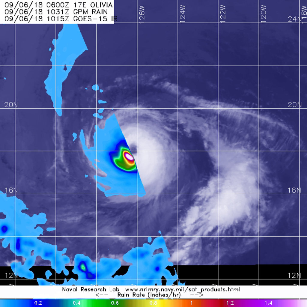
On Sept. 6 at 6:31 a.m. EDT (1031 UTC) the GPM core satellite provided an analysis of rainfall rates occurring in Hurricane Olivia. GPM found that heaviest rainfall rates were occurring around the eye at a rate of 1.5 inches (38 mm) per hour. Because the storm is compact, that area of heavy rainfall was also compact. Hurricane-force winds extend outward up to 25 miles (35 km) from the center and tropical-storm-force winds extend outward up to 115 miles (185 km).
At 5 a.m. EDT (0900 UTC) on Sept. 6, the National Hurricane Center or NHC noted the center of Hurricane Olivia was located near latitude 18.2 degrees north and longitude 126.5 degrees west. That’s about 1,125 miles (1,805 km) west-southwest of the southern tip of Baja California, Mexico.
Olivia is moving toward the west-northwest near 14 mph (22 kph), and this motion with some increase in forward speed is expected during the next couple of days. A gradual turn toward the west is expected over the weekend of Sept. 8 and 9.
Maximum sustained winds have increased to near 120 mph (195 kph) with higher gusts. Olivia is a category 3 hurricane on the Saffir-Simpson Hurricane Wind Scale. Some additional strengthening is possible today. After that, a gradual weakening trend is forecast to begin tonight or Friday.
For updates on Olivia, visit: www.nhc.noaa.gov
By Rob Gutro
NASA’s Goddard Space Flight Center
Sep. 05, 2018 – NASA Finds a Weaker Hurricane Olivia
Infrared data from NASA’s Terra satellite revealed that the area of coldest cloud topped thunderstorms has dropped from the previous day, indicating weaker uplift and less-strong storms.
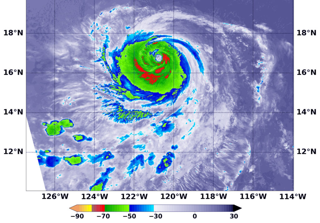
On Sept. 5 at 2:10 a.m. EDT (0610 UTC) NASA’s Terra satellite passed over Olivia and analyzed the storm in infrared light to show temperatures. The MODIS or Moderate Resolution Imaging Spectroradiometer instrument aboard NASA’s Aqua satellite revealed cloud top temperatures as cold or colder than minus 70 degrees Fahrenheit (minus 56.6 degrees Celsius) in fragmented areas southwest and east of the center. NASA research indicates very cold cloud tops with the potential to generate very heavy rainfall. At the time of the satellite image, Olivia had weakened but it was still a Category 3 hurricane.
Olivia encountered moderate easterly wind shear which continued to weaken the storm.
By 11 a.m. EDT (1500 UTC), the National Hurricane Center or NHC said Olivia weakened to a Category 2 hurricane on the Saffir-Simpson Hurricane Wind Scale. The center of Hurricane Olivia was located near latitude 17.1 degrees north and longitude 122.3 degrees west. Olivia was far from land areas. It was 900 miles (1,445 km) west-southwest of the southern tip of Baja California, Mexico.
Olivia is moving toward the west near 13 mph (20 kph), and this motion is expected to continue today. A turn toward the west-northwest is expected tonight, followed by a gradual turn back toward the west over the weekend.
Maximum sustained winds have decreased to near 110 mph (175 kph) with higher gusts. The NHC said additional slow weakening is expected during the next few days.
For updated forecasts, visit: www.nhc.noaa.gov
By Rob Gutro
NASA’s Goddard Space Flight Center
Sep. 04, 2018 – Infrared NASA Data Shows Hurricane Olivia’s Strongest Sides
NASA’s Aqua satellite passed over Hurricane Olivia and found bands of thunderstorms wrapping around its eye and improved thunderstorm development over the southern quadrant of the storm. The eastern quadrant also showed strong storms.
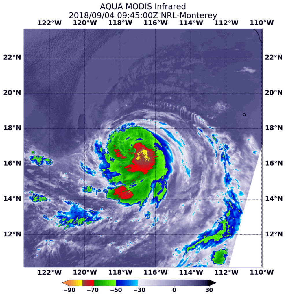
Infrared satellite data at 5:45 a.m. EDT (0945UTC) on Sept. 4, from the Moderate Resolution Imaging Spectroradiometer or MODIS instrument aboard NASA’s Aqua satellite showed coldest cloud top temperatures in Olivia in the eastern and southern quadrants. In those areas, cloud tops had temperatures near minus 70 degrees Fahrenheit (minus 56.6 degrees Celsius). NASA research has found that cloud top temperatures that cold have the capability to generate heavy rainfall.
Infrared data also provided forecasters with a look at surrounding sea surface temperatures (SSTs). Tropical cyclones require SSTs at least near 80 degrees Fahrenheit (26.6 degrees Celsius) to maintain strength. NHC forecasters noted at 5 a.m. EDT (0900 UTC) on Sept. 4 that “Olivia has about 24-36 hours or so remaining over warm SSTs with marginally favorable upper wind conditions.”
At 5 a.m. EDT (0900 UTC), the National Hurricane Center or NHC noted the center of Hurricane Olivia was located near latitude 16.9 degrees north and longitude 117.2 degrees west. That’s about 630 miles (1,015 km) southwest of the southern tip of Baja California, Mexico.
Olivia is moving toward the west near 12 mph (19 kph), and the hurricane is forecast to turn west-northwestward Wednesday with an increase in forward speed.
Maximum sustained winds are near 80 mph (130 kph) with higher gusts. Some strengthening is forecast, and Olivia could become a category 2 hurricane tonight, with gradual weakening commencing early Thursday, Sept. 6.
For updates on Olivia, visit: www.nhc.noaa.gov