Rebekah – North Atlantic Ocean

Nov. 01, 2019 – NASA Satellite Imagery Finds Rebekah Now Post-Tropical

NASA’s Terra Satellite provided a visible image of Post-Tropical Cyclone Rebekah as it continued moving in an easterly direction through the North Atlantic Ocean. Satellite data has confirmed that Rebekah is now a post-tropical cyclone.

Terra image of Rebekah
On Nov. 1 at 08:35 a.m. EDT (12:35 UTC), the MODIS instrument that flies aboard NASA’s Terra provided a visible image of Post-Tropical Cyclone Rebekah moving through the North Atlantic Ocean. Rebekah was devoid of strong thunderstorm development and appeared as a circulation of wispy clouds. Credit: NASA/NRL

At 5 a.m. EDT (0900 UTC) on Nov. 1, the center of Post-Tropical Cyclone Rebekah was located near latitude 40.6 degrees north and longitude 29.0 degrees west. That puts the center about 140 miles (225 km) north of Faial Island in the central Azores islands. The Azores are an archipelago or group of islands that are an autonomous region of Portugal.

The post-tropical cyclone is moving toward the east near 20 mph (31 kph) and this motion is expected to continue through tonight. Maximum sustained winds have decreased to near 35 mph (55 kph) with higher gusts. The estimated minimum central pressure is 1005 millibars. The National Hurricane Center (NHC) issued the final advisory on the system and Rebekah was designated post-tropical.

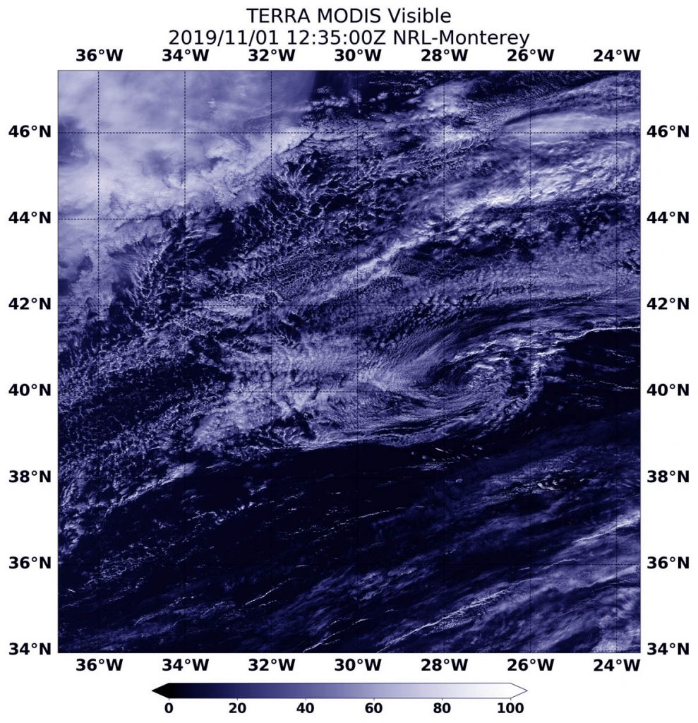
On Nov. 1 at 08:35 a.m. EDT (12:35 UTC), the Moderate Resolution Imaging Spectroradiometer or MODIS instrument that flies aboard NASA’s Terra satellite provided a visible image of Rebekah just after it was designated a post-tropical cyclone. The image revealed that Rebekah has degenerated to a remnant low-pressure area because the circulation was devoid of deep convection and strong thunderstorms. Rebekah appeared as a circulation of wispy clouds in the Terra satellite image.

A Post-Tropical Storm is a generic term for a former tropical cyclone that no longer possesses sufficient tropical characteristics to be considered a tropical cyclone. Former tropical cyclones can become fully extratropical, subtropical, or remnant lows, which are three classes of post-tropical cyclones. In any case, they no longer possesses sufficient tropical characteristics to be considered a tropical cyclone. However, post-tropical cyclones can continue carrying heavy rains and high winds.

NOAA’s National Hurricane Center discussion noted that Rebekah is starting to merge with a weak frontal system over the northeastern Atlantic. The remnants of Rebekah are expected to weaken to a trough or elongated area of low pressure between 12 and 24 hours.

Hurricanes are the most powerful weather event on Earth. NASA’s expertise in space and scientific exploration contributes to essential services provided to the American people by other federal agencies, such as hurricane weather forecasting.

For updated forecasts, visit: www.nhc.noaa.gov

By Rob Gutro
NASA’s Goddard Space Flight Center

Rebekah – North Atlantic Ocean

Oct. 31, 2019 – NASA Gets Infrared View of Atlantic Halloween Subtropical Storm

The latest addition to the Atlantic Ocean hurricane season developed quickly. NASA’s Aqua satellite passed over the eastern North Atlantic Ocean on Halloween and provided forecasters with an infrared view of Subtropical Storm Rebekah.

Aqua image of Rebekah
On Oct. 31, 2019 at 11:15 a.m. EDT (1515 UTC), NASA’s Aqua satellite revealed that Rebekah’s coldest cloud tops and strongest storms (yellow) were as cold as or colder than minus 50 degrees Fahrenheit (minus 45.5 Celsius) around the center of circulation in a band of thunderstorms wrapping into the center from the northeastern quadrant. Credit: NASA/NRL

Infrared data provides temperature information, and the strongest thunderstorms that reach high into the atmosphere have the coldest cloud top temperatures.

NASA’s Aqua satellite passed over Rebekah on Oct. 31, 2019 at 11:15 a.m. EDT (1515 UTC) and measured the cloud top temperatures. The strongest storms with coldest cloud tops were as cold as or colder than minus 50 degrees Fahrenheit (minus 45.5 Celsius) around the center of circulation in a band of thunderstorms wrapping into the center from the northeastern quadrant.

What is a Subtropical Storm?

Rebekah developed on Halloween eve, Oct. 30, by 5 p.m. EDT as a subtropical storm. NOAA’s National Hurricane Center defines subtropical storms as “A non-frontal low-pressure system that has characteristics of both tropical and extratropical cyclones. Like tropical cyclones, they are non-frontal, synoptic-scale cyclones that originate over tropical or subtropical waters, and have a closed surface wind circulation about a well-defined center. In addition, they have organized moderate to deep convection, but lack a central dense overcast. Unlike tropical cyclones, subtropical cyclones derive a significant proportion of their energy from baroclinic sources, and are generally cold-core in the upper troposphere, often being associated with an upper-level low or trough. In comparison to tropical cyclones, these systems generally have a radius of maximum winds occurring relatively far from the center (usually greater than 60 nautical miles), and generally have a less symmetric wind field and distribution of convection.

Rebekah’s Halloween Status

At 11 a.m. EDT (1500 UTC), the NHC or National Hurricane Center reported that the center of Subtropical Storm Rebekah was located near latitude 40.7 degrees north, longitude 35.3 west. The storm is moving toward the east-northeast near 18 mph (30 kph). An eastward turn with some increase in forward speed is anticipated by early Friday. Maximum sustained winds remain near 45 mph (75 kph) with higher gusts. Winds of 40 mph extend outward up to 70 miles (110 km) from the center. The estimated minimum central pressure is 990 millibars.

The storm should weaken and become a post-tropical cyclone by this evening or early tomorrow, Nov. 1. 

What is a Post-tropical Cyclone?

NHC defines a post-tropical cyclone as a former tropical cyclone. This generic term describes a cyclone that no longer possesses sufficient tropical characteristics to be considered a tropical cyclone. Post-tropical cyclones can continue carrying heavy rains and producing high winds. Note that former tropical cyclones that have become fully extratropical as well as remnant lows are two classes of post-tropical cyclones.

Hurricanes are the most powerful weather event on Earth. NASA’s expertise in space and scientific exploration contributes to essential services provided to the American people by other federal agencies, such as hurricane weather forecasting.

By Rob Gutro
NASA’s Goddard Space Flight Center