Sep. 15, 2020 – NASA Sees Tropical Depression Rene Dissipating
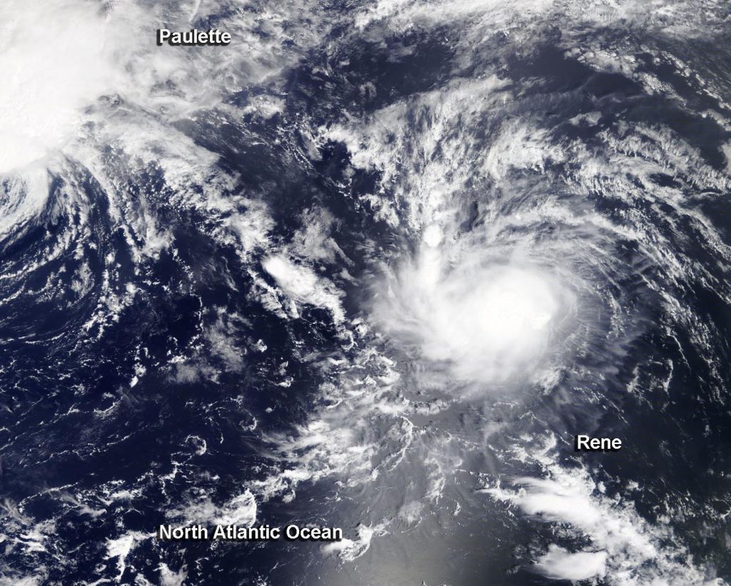
NASA’s Aqua satellite captured a visible image of Tropical Depression Rene as it was dissipating in the central North Atlantic Ocean.
On Sept. 15 at 12:30 p.m. EDT. NASA’s Aqua satellite provided a visible image of Tropical Depression Rene dissipating in the north central Atlantic Ocean. Image Courtesy: NASA Worldview, Earth Observing System Data and Information System (EOSDIS).
The Moderate Resolution Imaging Spectroradiometer or MODIS instrument that flies aboard NASA’s Aqua satellite captured a visible image of Rene on Sept. 15 at 12:30 p.m. EDT. Rene appeared elongated from wind shear (outside winds blowing at different levels of the atmosphere) battering the storm. Over the next couple of hours, visible satellite imagery showed that Rene opened into a trough (elongated area) of low pressure and was no longer a tropical cyclone. Several hours later, Rene dissipated into a remnant low-pressure area.
Satellite imagery was created using NASA’s Worldview product at NASA’s Goddard Space Flight Center in Greenbelt, Md.
Rene‘s Curtain Call
At 5 p.m. EDT (2100 UTC) on Sept. 15, NOAA’s National Hurricane Center (NHC) issued the final advisory on Rene, citing that the storm had dissipated. The remnants of Rene were located near latitude 26.9 degrees north and longitude 49.3 degrees west. Rene was located about 1,045 miles (1,685 km) northeast of the Leeward Islands. The remnants were moving toward the west-southwest near 7 mph (11 kph) and this general motion will likely continue for another day or two. Maximum sustained winds were near 30 mph (45 kph) with higher gusts.
The remnants of Rene are expected to move generally southwestward for the next day or two while the associated winds slowly subside.
About NASA’s Worldview and Aqua Satellite
NASA’s Earth Observing System Data and Information System (EOSDIS) Worldview application provides the capability to interactively browse over 700 global, full-resolution satellite imagery layers and then download the underlying data. Many of the available imagery layers are updated within three hours of observation, essentially showing the entire Earth as it looks “right now.”
NASA’s Aqua satellite is one in a fleet of NASA satellites that provide data for hurricane research.
Tropical cyclones/hurricanes are the most powerful weather events on Earth. NASA’s expertise in space and scientific exploration contributes to essential services provided to the American people by other federal agencies, such as hurricane weather forecasting.
Sep. 14, 2020 – NASA’s Aqua Satellite Finds Rene Barely a Depression Battered by Wind Shear
Tropical Depression Rene continues to be the victim of strong wind shear and forecasters anticipate it will lead to the storm’s demise in the next couple of days. NASA’s Aqua satellite viewed the storm in infrared light to find wind shear was pushing Rene’s strongest storms away from the center, preventing the storm from re-organizing and strengthening.
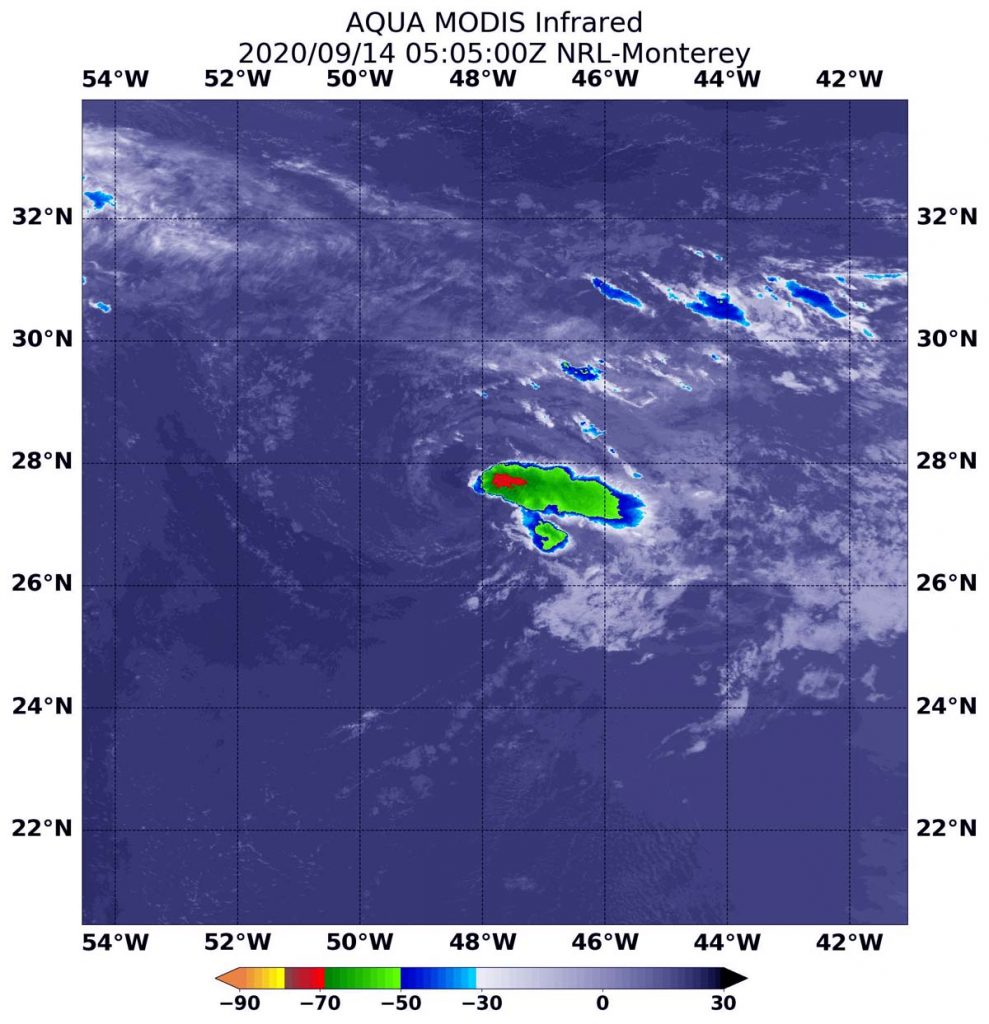
On Sept. 15 at 1:05 a.m. EDT (0505 UTC), the MODIS instrument that flies aboard NASA’s Aqua satellite gathered infrared data on Rene that confirmed wind shear was adversely affecting the storm. Persistent north-northeasterly vertical wind shear showed strongest storms (red) pushed to the east-southeast of the center where cloud top temperatures were as cold as minus 70 degrees Fahrenheit (minus 56.6 Celsius). Credit: NASA/NRL
NASA’s Aqua Satellite Reveals Effects of Wind Shear
On instrument aboard NASA’s Aqua satellite uses infrared light to analyze cloud top temperatures in a tropical cyclone’s clouds to determine strength. The strongest thunderstorms that reach high into the atmosphere have the coldest cloud top temperatures.
On Sept. 15 at 1:05 a.m. EDT (0505 UTC), the Moderate Resolution Imaging Spectroradiometer or MODIS instrument that flies aboard NASA’s Aqua satellite gathered infrared data on Rene that confirmed wind shear was adversely affecting the storm. Persistent north-northeasterly vertical wind shear showed strongest storms (red) pushed to the east-southeast of the center where cloud top temperatures were as cold as minus 70 degrees Fahrenheit (minus 56.6 Celsius).
National Hurricane Center forecaster Jack Beven noted, “Rene continues to produce just enough deep convection to keep it from degenerating to a remnant low. However, it is expected to degenerate later today due to the ongoing impact of strong west-northwesterly vertical shear and dry air entrainment.”
Wind Shear Affecting Rene
The shape of a tropical cyclone provides forecasters with an idea of its organization and strength. When outside winds batter a storm, it can change the storm’s shape and push much of the associated clouds and rain to one side of it. That is what wind shear does.
In general, wind shear is a measure of how the speed and direction of winds change with altitude. Tropical cyclones are like rotating cylinders of winds. Each level needs to be stacked on top each other vertically in order for the storm to maintain strength or intensify. Wind shear occurs when winds at different levels of the atmosphere push against the rotating cylinder of winds, weakening the rotation by pushing it apart at different levels.
Status of Tropical Depression Rene
At 5 a.m. EDT (0900 UTC), the center of Tropical Depression Rene was located near latitude 27.4 degrees north and longitude 48.3 degrees west. Rene is centered about 1,115 miles (1,795 km) northeast of the Leeward Islands. The depression is moving toward the west near 3 mph (6 km/h). Maximum sustained winds are near 30 mph (45 kph) with higher gusts. The estimated minimum central pressure is 1011 millibars.
Rene’s Forecast
A faster motion toward the west-southwest or southwest is forecast to begin later today, Sept. 14 and continue through dissipation. Weakening is forecast, and Rene is expected to become a remnant low later today and dissipate by Wednesday, Sept. 16.
NASA Researches Tropical Cyclones
Hurricanes/tropical cyclones are the most powerful weather events on Earth. NASA’s expertise in space and scientific exploration contributes to essential services provided to the American people by other federal agencies, such as hurricane weather forecasting.
For more than five decades, NASA has used the vantage point of space to understand and explore our home planet, improve lives and safeguard our future. NASA brings together technology, science, and unique global Earth observations to provide societal benefits and strengthen our nation. Advancing knowledge of our home planet contributes directly to America’s leadership in space and scientific exploration.
Sep. 11, 2020 – NASA Satellite Finds an Elongated Tropical Storm Rene Caused by Wind Shear
Infrared imagery from NASA’s Aqua satellite showed an elongated Tropical Storm Rene being battered by wind shear in the Central Atlantic Ocean. Tropical cyclones that appear less than round are likely being affected by wind shear or outside winds transitioning into an extra-tropical cyclone or taking on the elongated appearance of a weather front. Outside winds have given Rene’s strongest storms an appearance like that of a triangle.
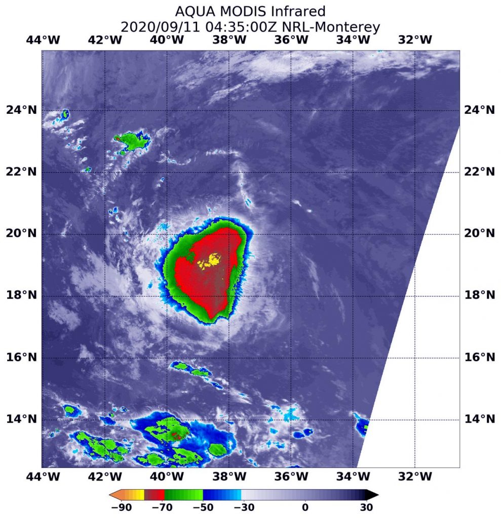
On Sept. 11 at 12:35 a.m. EDT (0435 UTC), the MODIS instrument that flies aboard NASA’s Aqua satellite revealed a small area of the most powerful thunderstorms (yellow) around Rene’s center where cloud top temperatures were as cold as minus 80 degrees Fahrenheit (minus 62.2 Celsius). A larger area of strong storms (red) with cloud top temperatures as cold as minus 70 degrees Fahrenheit (minus 56.6. degrees Celsius) surrounded the center and were generating large amounts of rain. Credit: NASA/NRL
Wind Shear Affecting Rene
The shape of a tropical cyclone provides forecasters with an idea of its organization and strength. When outside winds batter a storm, it can change the storm’s shape. Winds can push most of the associated clouds and rain to one side of a storm.
In general, wind shear is a measure of how the speed and direction of winds change with altitude. Tropical cyclones are like rotating cylinders of winds. Each level needs to be stacked on top each other vertically in order for the storm to maintain strength or intensify. Wind shear occurs when winds at different levels of the atmosphere push against the rotating cylinder of winds, weakening the rotation by pushing it apart at different levels.
Infrared Data Reveals Effects of Wind Shear
NASA’s Aqua satellite uses infrared light to analyze the strength of storms by providing temperature information about the system’s clouds. The strongest thunderstorms that reach high into the atmosphere have the coldest cloud top temperatures.
On Sept. 11 at 12:35 a.m. EDT (0435 UTC), the Moderate Resolution Imaging Spectroradiometer or MODIS instrument that flies aboard NASA’s Aqua satellite revealed a small area of Rene’s most powerful thunderstorms around its center where cloud top temperatures were as cold as minus 80 degrees Fahrenheit (minus 62.2 Celsius). A larger area of strong storms with cloud top temperatures as cold as minus 70 degrees Fahrenheit (minus 56.6. degrees Celsius) surrounded the center in what looks like a triangular shape. NASA research has found that storms with cloud tops as cold as at least minus 70 degrees Fahrenheit can generate heavy rain.
At 5 a.m. EDT on Sept. 11, U.S. Navy Hurricane Specialist, Dave Roberts of NOAA’s National Hurricane Center in Miami, Fla. noted in the Rene discussion, “A microwave pass revealed that Rene’s surface center is farther separated from the shrinking deep convection. Model soundings indicate that east-southeasterly 30 to 25 knot [vertical wind] shear near 300 millibars is temporarily undercutting the diffluent southerly flow aloft.” An air pressure of 300 millibars is about 30,000 feet (9,100 meters) high in the atmosphere, but it can vary between 27,000 to 32,000 feet (8,200 to 9,600 meters).
The wind shear Rene is currently experiencing is expected to relax during the next 36 to 48 hours (from 5 a.m. EDT on Sept. 11) which should allow for gradual intensification. “By mid-period, Rene is forecast to move into an area of increasing west-northwesterly shear, which should induce a weakening trend,” Roberts noted.
Rene’s Status on Sept. 11
At 5 a.m. EDT (0900 UTC), the center of Tropical Storm Rene was located near latitude 19.7 degrees north and longitude 38.5 degrees west. Rene is 985 miles (1,585 km) west-northwest of the Cabo Verde Islands. Rene is moving toward the west-northwest near 10 mph (17 kph). This general motion is expected to continue through Friday night, followed by a turn toward the northwest on Saturday. Maximum sustained winds are near 45 mph (75 kph) with higher gusts. The estimated minimum central pressure is 1002 millibars.
Rene’s Weekend Forecast
NHC forecasters expect a north-northwestward and northward motion with a decrease in forward speed on Sunday and Sunday night [Sept. 13]. Gradual strengthening is forecast during the couple of days. Afterward, weakening is expected to begin by Sunday night.
NASA Researches Earth from Space
For more than five decades, NASA has used the vantage point of space to understand and explore our home planet, improve lives and safeguard our future. NASA brings together technology, science, and unique global Earth observations to provide societal benefits and strengthen our nation. Advancing knowledge of our home planet contributes directly to America’s leadership in space and scientific exploration.
Sep. 10, 2020 – NASA Finds Tropical Storm Rene Less Affected by Wind Shear
NASA’s Terra satellite obtained visible imagery of Tropical Storm Rene is it continued moving north though the central North Atlantic Ocean. Rene appeared more organized on satellite imagery as wind shear eased.
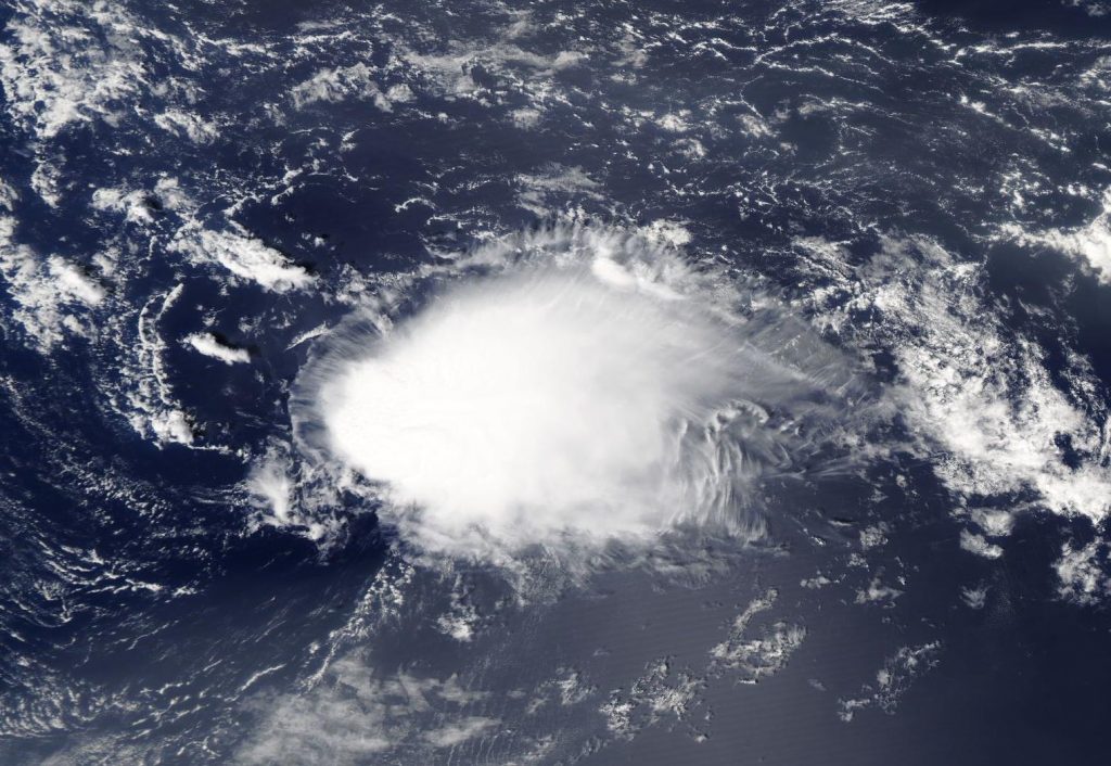
On Sept. 10, 2020, NASA’s Terra satellite provided a visible image of Tropical Storm Rene, and the eastern side of Tropical Storm Paulette (top left) moving through the Atlantic Ocean. Image Courtesy: NASA Worldview, Earth Observing System Data and Information System (EOSDIS).
NASA Satellite View: Rene’s Organization
The Moderate Resolution Imaging Spectroradiometer or MODIS instrument that flies aboard NASA’s Terra satellite captured a visible image of Tropical Storm Rene on Sept. 10. Rene appeared slightly more circular. That is because vertical wind shear (outside winds blowing at different levels of the atmosphere) appears to have lessened somewhat over Rene allowing the storm to organize. The image showed Tropical Storm Paulette was located to Rene’s northwest.
Satellite imagery was created using NASA’s Worldview product at NASA’s Goddard Space Flight Center in Greenbelt, Md.
Rene on Sept. 10
At 11 a.m. EDT (1500 UTC) on Sept. 10, the center of Tropical Storm Rene was located near latitude 18.6 degrees north and longitude 35.8 degrees west. Rene was about 800 miles (1,285 km) west-northwest of the Cabo Verde Islands.
Rene is moving toward the west-northwest near 12 mph (19 kph). This general motion is expected to continue for the next couple of days, followed by a turn toward the northwest. Maximum sustained winds have increased to near 50 mph (85 kph) with higher gusts. The estimated minimum central pressure is 1000 millibars.
NOAA’s National Hurricane Center (NHC) noted that additional strengthening is forecast for the next couple of days as vertical wind shear is not expected to be strong. Therefore, Rene is expected to become a hurricane by Saturday, Sept. 12. The storm is not expected to affect any land areas in the next five days, according to the NHC forecast.
About NASA’s Worldview and Terra Satellite
NASA’s Earth Observing System Data and Information System (EOSDIS) Worldview application provides the capability to interactively browse over 700 global, full-resolution satellite imagery layers and then download the underlying data. Many of the available imagery layers are updated within three hours of observation, essentially showing the entire Earth as it looks “right now.”
NASA’s Terra satellite is one in a fleet of NASA satellites that provide data for hurricane research.
Tropical cyclones/hurricanes are the most powerful weather events on Earth. NASA’s expertise in space and scientific exploration contributes to essential services provided to the American people by other federal agencies, such as hurricane weather forecasting.
Sep. 09, 2020 – NASA Infrared Imagery Shows Tropical Storm Rene’s Seesaw of Strength
Tropical Storm Rene weakened to a tropical depression late on Sept. 8 but regained tropical storm status on Sept. 9. Infrared imagery from NASA’s Aqua satellite captured Rene as it was twice transitioning.
Rene has been battling wind shear in the eastern North Atlantic Ocean and when NASA’s Aqua satellite passed over the storm on Sept. 8, it found Rene weakening although still a tropical storm. Wind shear occurs when winds blowing outside of a tropical cyclone at different levels of the atmosphere push against the tropical cyclone and weaken it.
NASA’s Infrared Views of Rene
Tropical cyclones are made up of hundreds of thunderstorms, and infrared data can show where the strongest storms are located. That is because infrared data provides temperature information, and the strongest thunderstorms that reach highest into the atmosphere have the coldest cloud top temperatures.
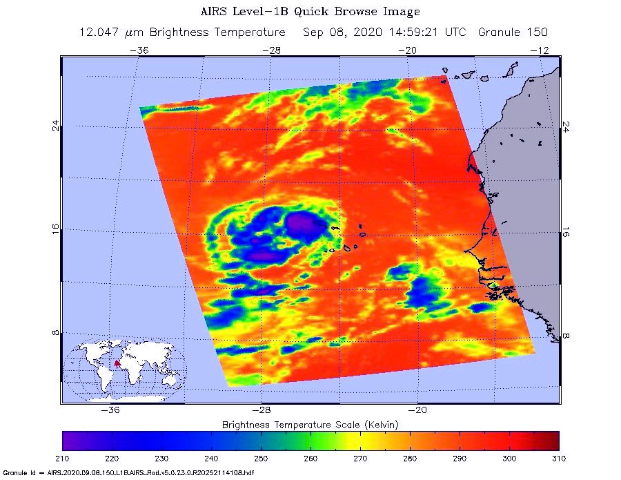
On Sept. 8 at 10:59 a.m. EDT (1459 UTC), NASA’s Aqua satellite analyzed Rene’s cloud top temperatures. Imagery showed the strongest storms (purple) east of the center of circulation, and in fragmented bands west of the center where coldest cloud top temperatures as cold as or colder 210 Kelvin minus 81 degrees Fahrenheit (minus 63.1 degrees Celsius). Credit: NASA JPL/Heidar Thrastarson
On Sept. 8 at 10:59 a.m. EDT (1459 UTC), NASA’s Aqua satellite analyzed the storm using the Atmospheric Infrared Sounder or AIRS instrument. The AIRS imagery showed the strongest storms east of the center of circulation, and in fragmented bands west of the center where coldest cloud top temperatures as cold as or colder 210 Kelvin minus 81 degrees Fahrenheit (minus 63.1 degrees Celsius). NASA research has shown that cloud top temperatures that cold indicate strong storms that have the capability to create heavy rain.
By 11 p.m. EDT on Sept. 8, although Rene had weakened to a tropical depression, infrared imagery revealed a burst of strong convection with cloud tops colder than minus 80 degrees Celsius (minus 112 Fahrenheit) had developed over and to the west of the center, while a fragmented band of convection had formed in the northern semicircle.
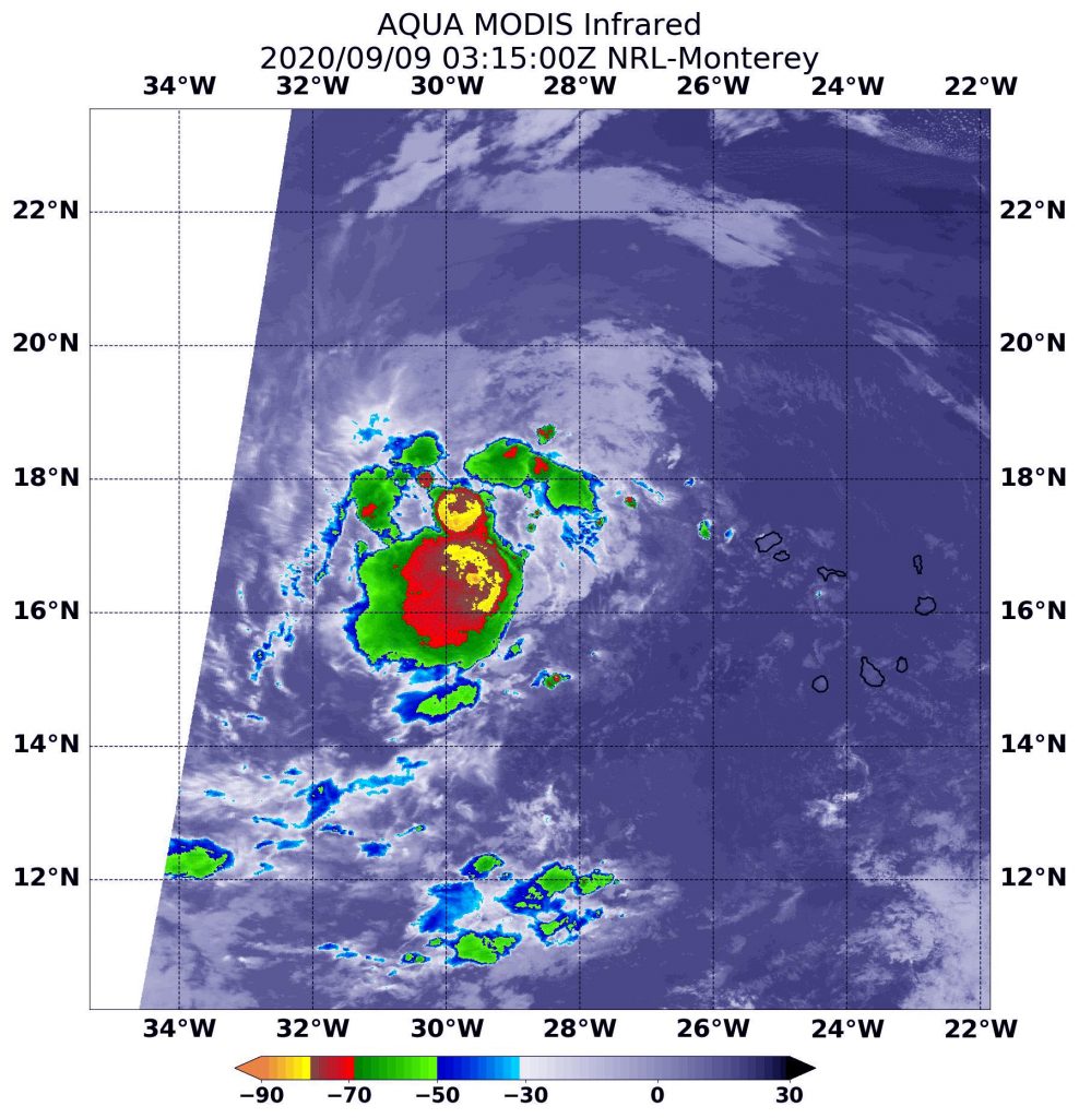
On Sept. 8 at 11:15 p.m. EDT (Sept. 9 at 0315 UTC), the Moderate Resolution Imaging Spectroradiometer or MODIS instrument that flies aboard NASA’s Aqua satellite used infrared light to analyze the strength of storms within Rene. MODIS showed that burst of convection and showed the most powerful thunderstorms had cloud top temperatures were as cold as or colder than minus 80 degrees Fahrenheit (minus 62.2 Celsius). Strong storms with cloud top temperatures as cold as minus 70 degrees Fahrenheit (minus 56.6. degrees Celsius) surrounded that area. NASA research has found that cloud top temperatures that cold indicate strong storms with the potential to generate heavy rainfall.
On Sept. 8 at 11:15 p.m. EDT (Sept. 9 at 0315 UTC), the MODIS instrument that flies aboard NASA’s Aqua satellite revealed the most powerful thunderstorms (yellow) had cloud top temperatures as cold as or colder than minus 80 degrees Fahrenheit (minus 62.2 Celsius). Strong storms with cloud top temperatures as cold as minus 70 degrees Fahrenheit (minus 56.6. degrees Celsius) surrounded that area. Credit: NASA/NRL
Rene’s outflow was symmetrical in all quadrants, but because scatterometer data showed that its winds dropped to 30 knots (35 mph/56 kph) per hour, it was classified as a tropical depression. Less than six hours later, infrared imagery showed Rene was becoming better organized and in an additional six hours, it would regain its strength.
On Sept. 9 at 11 a.m. EDT, Richard Pasch, Senior Hurricane Specialist at NOAA’s National Hurricane Center in Miami, Fla. noted, “Although easterly wind shear has been affecting the system, Rene is producing vigorous deep convection, along with a broad convective band, over its western semicircle. Scatterometer data indicate winds to 35 knots [40 mph/65 kph] over the northwestern quadrant, and therefore the system is again being designated as a tropical storm.”
Rene’s Status on Sept. 9
At 11 a.m. EDT (1500 UTC) on Sept. 9, Rene re-strengthened into a tropical storm. At that time, the center of Tropical Storm Rene was located near latitude 17.6 degrees north and longitude 31.5 degrees west. Rene is moving toward the west-northwest near 13 mph (20 kph). The estimated minimum central pressure is 1003 millibars. Satellite-derived wind data indicate that the maximum sustained winds have increased to near 40 mph (65 kph) with higher gusts.
Rene’s Forecast from NHC
The NHC forecasts additional strengthening during the next 48 hours and a motion toward the west-northwest is expected for the next couple of days, followed by a turn to the northwest.
NASA Researches Earth from Space
For more than five decades, NASA has used the vantage point of space to understand and explore our home planet, improve lives and safeguard our future. NASA brings together technology, science, and unique global Earth observations to provide societal benefits and strengthen our nation. Advancing knowledge of our home planet contributes directly to America’s leadership in space and scientific exploration.
Sep. 08, 2020 – NASA-NOAA Satellite Sees New Tropical Storm Rene Drenching Cabo Verde Islands
NASA-NOAA’s Suomi NPP satellite provided forecasters with a visible image of the latest tropical cyclone in the North Atlantic hurricane season. Tropical Storm Rene was bringing tropical-storm force winds and rain to the Cabo Verde Islands.
On Sept. 8, NASA-NOAA’s Suomi NPP satellite provided forecasters with a visible image of Tropical Storm Rene over the Cabo Verde islands in the eastern North Atlantic Ocean. The African coast is seen to the east (right). Credit: NASA Worldview, Earth Observing System Data and Information System (EOSDIS)
Cabo Verde, also known as Cape Verde, is a country consisting of a chain of islands, located about 385 miles (620 km) off the west coast of Africa.
Tropical Depression 18 developed on Monday, Sept. 7 in the far eastern North Atlantic Ocean, about 250 miles (405 km) east-southeast of the Cabo Verde Islands. By 5 p.m. EDT (2100 UTC) on Sept. 7, the depression strengthened into a tropical storm and was renamed Rene.
On Sept. 8, a Tropical Storm Warning was in effect for the Cabo Verde Islands. The Visible Infrared Imaging Radiometer Suite (VIIRS) instrument aboard Suomi NPP provided a visible image of Rene when it passed overhead. The imagery showed that the tropical storm has a well-defined circulation. However, the banding of thunderstorms around the center has shown no increased organization since Sept. 7.
At 11 a.m. EDT (1500 UTC) on Sept. 8, Tropical Storm Rene was bringing tropical-storm force winds and heavy rain to the western Cabo Verde Islands. The center of Tropical Storm Rene was located near latitude 16.5 degrees north and longitude 26.5 degrees west. Rene was moving toward the west near 16 mph (26 kph), and a motion toward the west to west-northwest is expected over the next two or three days. Maximum sustained winds are near 40 mph (65 kph) with higher gusts. The estimated minimum central pressure is 1001 millibars.
On the forecast track, the center of Rene will move away from the Cabo Verde Islands later today. Little change in strength is expected today, followed by gradual strengthening on Thursday and Friday. Rene is forecast to become a hurricane in a couple of days.
NASA Researches Tropical Cyclones
Hurricanes/tropical cyclones are the most powerful weather events on Earth. NASA’s expertise in space and scientific exploration contributes to essential services provided to the American people by other federal agencies, such as hurricane weather forecasting.
For more than five decades, NASA has used the vantage point of space to understand and explore our home planet, improve lives and safeguard our future. NASA brings together technology, science, and unique global Earth observations to provide societal benefits and strengthen our nation. Advancing knowledge of our home planet contributes directly to America’s leadership in space and scientific exploration.