Sebastien – Atlantic Ocean

Nov. 25, 2019 – NASA Tracking Extra-Tropical Storm Sebastien towards the U.K.

NASA’s Aqua satellite passed over eastern North Atlantic Ocean and captured an infrared view of what is now Extra-tropical cyclone Sebastien. Sebastien transitioned from a tropical storm to an extra-tropical storm on Nov. 24. It has coupled with a cold front and is now headed for the United Kingdom.
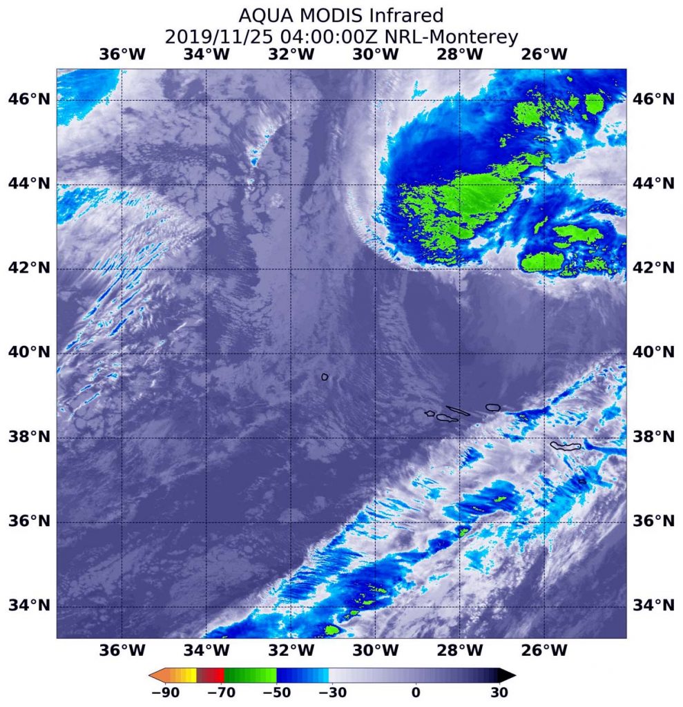
Aqua image of Sebastien
On Nov. 25 at 0400 UTC (Nov. 24 at 11 p.m. EST) the MODIS instrument that flies aboard NASA’s Aqua satellite revealed that Extra-tropical cyclone Sebastien’s strongest storms had cloud tops as cold as or colder than minus 50 degrees Fahrenheit (minus 45.5 Celsius). Credit: NASA/NRL

Sebastien’s Final Advisory

At 10 p.m. EST on Sunday, Nov. 24 (0300 UTC Nov. 25), NOAA’s National Hurricane Center (NHC) issued the final advisory on Sebastien. At that time, the center of Post-Tropical Cyclone Sebastien was located near latitude 41.0 degrees north and longitude 28.9 degrees west. It was centered 230 miles (370 km) north-northwest of the Azores Islands. Sebastien was moving toward the northeast near 40 mph (65 kph) and this motion is expected to continue for the next day or so. Maximum sustained winds are near 60 mph (95 kph) with higher gusts. Post-tropical cyclone Sebastien should maintain its intensity before merging with another low during the next day or two. The estimated minimum central pressure is 993 millibars. 

NHC’s Forecaster Latto noted “Sebastien has lost its tropical characteristics this evening. The deep convection has decoupled from the low-level circulation, and these features are now separated by a distance of 100 nautical miles and increasing. Two [satellite] passes revealed that the surface low is becoming stretched out, and there is some evidence of a boundary, possibly a front, extending northeast from the center. Furthermore, recent observations from the Azores indicated a slight temperature decrease as the center passed by to the north of those islands, suggesting that a weak cold front is associated with the cyclone. Based on all of these data, there is high confidence that Sebastien has transitioned to an extratropical cyclone.”

What does Extra-tropical Mean?

When a storm becomes extra-tropical, it means that a tropical cyclone has lost its “tropical” characteristics. The National Hurricane Center defines “extra-tropical” as a transition that implies both poleward displacement (meaning it moves toward the north or south pole) of the cyclone and the conversion of the cyclone’s primary energy source from the release of latent heat of condensation to baroclinic (the temperature contrast between warm and cold air masses) processes. It is important to note that cyclones can become extratropical and still retain winds of hurricane or tropical storm force.

NASA’s Infrared View of Sebastien

NASA’s Aqua satellite used infrared light to analyze the strength of storms in Sebastien. Infrared data provides temperature information, and the strongest thunderstorms that reach high into the atmosphere have the coldest cloud top temperatures. On Nov. 25 at 0400 UTC (Nov. 24 at 11 p.m. EST), Aqua passed over the storm after it had become associated with a cold front. The coldest cloud top temperatures were near minus 50 degrees Fahrenheit or minus 45.5 degrees Celsius. The infrared imagery revealed that the strongest precipitation had become elongated, resembling a frontal system.

Sebastien Headed to the U.K.

The United Kingdom Meteorological Service noted that rains from Sebastien are headed toward the U.K. by Tuesday. The storm is forecast to affect southern England and then move northeast. The Met Office warned that flood-ravaged areas may be affected by more heavy rain over the next several days. The U.K. Met Service issued several yellow weather warnings in southwest and northeast England as torrential showers are expected from Sebastien’s remnants. For updated forecasts, visit: https://www.metoffice.gov.uk/

Hurricanes are the most powerful weather event on Earth. NASA’s expertise in space and scientific exploration contributes to essential services provided to the American people by other federal agencies, such as hurricane weather forecasting.

By Rob Gutro
NASA’s Goddard Space Flight Center

Sebastien – Atlantic Ocean

Nov. 22, 2019 – NASA’s Infrared Analysis of Tropical Storm Sebastien Sees Wind Shear

Tropical Storm Sebastian continued to move in a northeasterly direction through the North Atlantic Ocean as NASA’s Aqua satellite passed overhead. Infrared imagery from an instrument aboard Aqua revealed very high, powerful storms with very cold cloud top temperatures in the southwestern quadrant of the storm.  It also revealed that the storm was being sheared apart by outside winds.

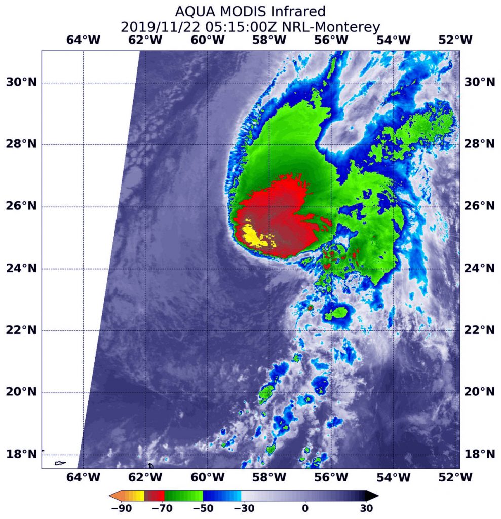
Aqua image of Sebastien
On Nov. 22 at 1:15 a.m. EST (0515 UTC) the MODIS instrument that flies aboard NASA’s Aqua satellite showed on area in Sebastien’s southwestern corner where cloud top temperatures were as cold as or colder than (in yellow) minus 80 degrees Fahrenheit (minus 62.2 Celsius). Credit: NASA/NRL

Tropical cyclones are made of up hundreds of thunderstorms and infrared data can show where the strongest storms are located. They can do that because infrared data provides temperature information, and the strongest thunderstorms that reach highest into the atmosphere have the coldest cloud top temperatures.

On Nov. 22 at 1:15 a.m. EST (0515 UTC), the Moderate Resolution Imaging Spectroradiometer or MODIS instrument that flies aboard NASA’s Aqua satellite used infrared light to analyze the strength of storms within the tropical cyclone. MODIS found those strongest storms only in the southwestern side of the storm where cloud top temperatures were as cold as or colder than minus 80 degrees Fahrenheit (minus 62.2 Celsius). NASA research has found that cloud top temperatures that cold indicate strong storms with the potential to generate heavy rainfall.

The reason the strongest storms were happening only in that quadrant is that outside winds from the southwest are pushing the bulk of clouds and precipitation to the northeast. In general, wind shear is a measure of how the speed and direction of winds change with altitude. Tropical cyclones are like rotating cylinders of winds. Each level needs to be stacked on top each other vertically in order for the storm to maintain strength or intensify. Wind shear occurs when winds at different levels of the atmosphere push against the rotating cylinder of winds, weakening the rotation by pushing it apart at different levels.

At 11 a.m. EST (1500 UTC), the center of Tropical Storm Sebastien was located near latitude 25.2 degrees north and longitude 55.3 degrees west about 695 miles (1,120 km) northeast of the Northern Leeward Islands.

Sebastien is moving toward the east-northeast near 15 mph (24 kph). An east-northeastward or northeastward motion at a similar forward speed is expected through the weekend of Nov. 23 and 24. Maximum sustained winds have decreased to near 50 mph (85 kph) with higher gusts.  The estimated minimum central pressure is 1,000 millibars.

The National Hurricane Center said that strong wind shear is expected to prevent Sebastien from getting better organized, so gradual weakening is anticipated. Sebastien is forecast to dissipate by early next week.

Hurricanes are the most powerful weather event on Earth. NASA researches these storms to determine how they rapidly intensify, develop and behave. NASA’s expertise in space and scientific exploration contributes to essential services provided to the American people by other federal agencies, such as hurricane weather forecasting.
By Rob Gutro
NASA’s Goddard Space Flight Center

Sebastien – Atlantic Ocean

Nov. 21, 2019 – NASA Found Atlantic’s Sebastien Was Fighting Wind Shear

NASA’s Terra satellite captured a visible image of Tropical Storm Sebastien that showed wind shear had pushed the bulk of its clouds and showers to the southeast of the center.

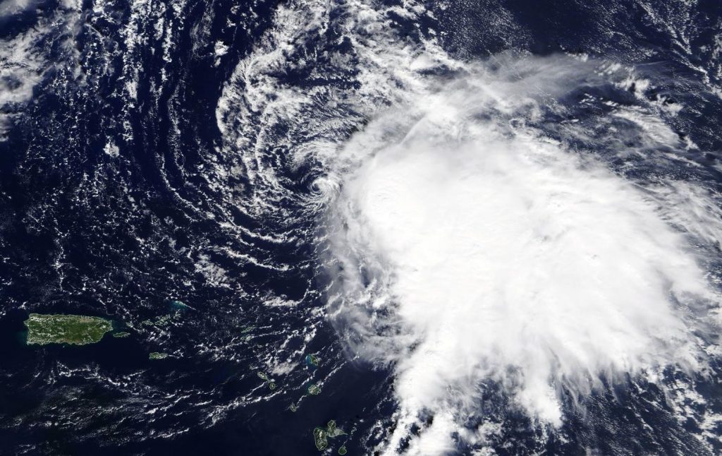
Terra image of Sebastien
On Nov. 20, 2019, the MODIS instrument that flies aboard NASA’s Terra satellite provided a visible image of Tropical Storm Sebastien in the Atlantic Ocean. Puerto Rico can be seen to the left of the storm. Credit: NASA Worldview

In general, wind shear is a measure of how the speed and direction of winds change with altitude. Tropical cyclones are like rotating cylinders of winds. Each level needs to be stacked on top each other vertically in order for the storm to maintain strength or intensify. Wind shear occurs when winds at different levels of the atmosphere push against the rotating cylinder of winds, weakening the rotation by pushing it apart at different levels.

On Nov. 20, the Moderate Resolution Imaging Spectroradiometer or MODIS instrument that flies aboard NASA’s Terra satellite provided a visible image of Tropical Storm Sebastien. The MODIS image showed the center of circulation appeared to be surrounded by wispy clouds, and that northwesterly wind shear had pushed the bulk of Sebastien’s clouds and showers southeast of the center. In addition, the low-level center of circulation was exposed to outside winds.

On Nov. 21, the National Hurricane Center Sebastien said that the storm continues to produce a large area of deep convection over the eastern semicircle of the circulation, but the banding features are not very well defined.

On Nov. 21 at 10 a.m. EST (1500 UTC), the center of Tropical Storm Sebastien was located near latitude 23.5 degrees north and longitude 60.5 degrees west about 405 miles (650 km) north-northeast of the Northern Leeward Islands.

Sebastien is moving toward the north-northeast near 8 mph (13 kph).  A faster northeastward motion is expected during the next few days. The estimated minimum central pressure is 999 millibars.

Maximum sustained winds are near 60 mph (95 kph) with higher gusts. Sebastien is forecast to become a hurricane by tonight, but a weakening trend is expected to begin by late Friday. The system is likely to become an extratropical cyclone by Saturday when it is forecast to become embedded in a frontal zone.

NASA’s Terra satellite is one in a fleet of NASA satellites that provide data for hurricane research.

Hurricanes and typhoons are the most powerful weather event on Earth. NASA’s expertise in space and scientific exploration contributes to essential services provided to the American people by other federal agencies, such as hurricane weather forecasting.

By Rob Gutro
NASA’s Goddard Space Flight Center

Sebastien – Atlantic Ocean

Nov. 20, 2019 – NASA Estimates Tropical Storm Sebastien’s Rainfall Rates

NASA found moderate rainfall occurring over a large area in Tropical Storm Sebastien, as it moves through the Atlantic Ocean.

IMERG data of Sebastien
When IMERG analyzed Tropical Storm Sebastien on Nov. 19, calculations indicated moderate rainfall occurring. Rainfall rates around 17.0 mm or 0.7 inches per hour (red) were falling east of the low-level center. Lighter rainfall rates appear in yellow. Credit: JAXA/NASA Worldview

NASA has the unique ability to measure and calculate rainfall rates in storms from the Global Precipitation Measurement mission or GPM satellite. That data is combined with data from other satellites to form NASA’s Integrated Multi-satellitE Retrievals for GPM (IMERG) forecast .

The near-real time rain estimate comes from the NASA’s IMERG algorithm, which combines observations from a fleet of satellites, in near-real time, to provide near-global estimates of precipitation every 30 minutes. By combining NASA precipitation estimates with other data sources, we can gain a greater understanding of the major storms that affect our planet.

When IMERG analyzed Tropical Storm Sebastien on Nov. 19, calculations indicated moderate rainfall occurring. Rainfall rates around 17.0 mm or 0.7 inches per hour were falling east of the center. Sebastien continues to struggle with dry air and northwesterly wind shear, with satellite imagery showing an exposed low-level center to the west of the deep convection.

Sebastien’s Status on Nov. 20

NOAA’s National Hurricane Center or NHC reported on Nov. 20 at 5 a.m. EST (0900 UTC), the center of Tropical Storm Sebastien was located near latitude 21.0 degrees north and longitude 61.0 degrees west. That is about 235 miles (380 km) northeast of the Northern Leeward Islands.

Sebastien is moving toward the northwest near 8 mph (13 kph). A turn to the north-northwest and then north is expected later today. A turn toward the northeast with an increase in forward speed is expected tonight and Thursday. Maximum sustained winds have increased to near 50 mph (85 kph) with higher gusts. Some strengthening is forecast during the next 48 hours. Tropical-storm-force winds extend outward up to 150 miles (240 km) from the center. The estimated minimum central pressure is 1002 millibars.

 About IMERG

IMERG fills in the “blanks” between weather observation stations. IMERG satellite-based rain estimates can be compared to that from a National Weather Service ground radar.  Such good detection of large rain features in real time would be impossible if the IMERG algorithm merely reported the precipitation observed by the periodic overflights of various agencies’ satellites.  Instead, what the IMERG algorithm does is “morph” high-quality satellite observations along the direction of the steering winds to deliver information about rain at times and places where such satellite overflights did not occur.  Information morphing is particularly important over the majority of the world’s surface that lacks ground-radar coverage.

Sebastien’s Fate

Sebastien is expected to become an extratropical cyclone in a couple of days and be absorbed by a cold front on Friday, Nov. 22.

Hurricanes are the most powerful weather event on Earth. NASA’s expertise in space and scientific exploration using a fleet of satellites contributes to essential services provided to the American people by other federal agencies, such as hurricane weather forecasting.
For more information about NASA’s IMERG, visit: https://pmm.nasa.gov/gpm/imerg-global-image

For local forecasts, visit: www.weather.gov

By Rob Gutro
NASA’s Goddard Space Flight Center


Sebastien – Atlantic Ocean

Nov. 19, 2019 – NASA Identifies New Atlantic Tropical Storm Sebastien

NASA’s Aqua satellite captured an image of newly formed Tropical Storm Sebastien, located northeast of the Leeward Islands in the Atlantic Ocean.

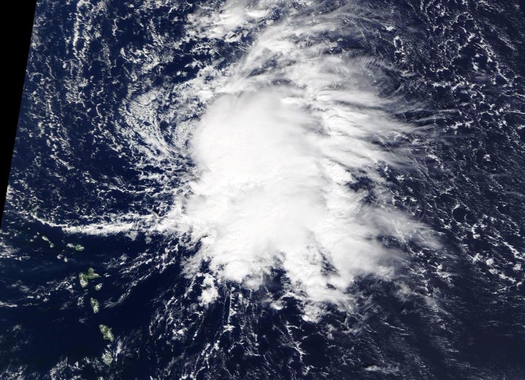
Aqua image of Sebastien
On Nov. 19, 2019, the MODIS instrument that flies aboard NASA’s Aqua satellite provided a visible image of newly formed Tropical Storm Sebastien, just east of the Northern Leeward Islands in the Atlantic Ocean. Credit: NASA Worldview

On Nov. 19, the Moderate Resolution Imaging Spectroradiometer or MODIS instrument that flies aboard NASA’s Aqua satellite provided a visible image of Sebastien. The MODIS image showed that the overall cloud pattern of the disturbance has improved since yesterday, Nov. 18, and that the low-pressure area has become well-defined.

NOAA’s National Hurricane Center or NHC noted at 11 a.m. EST (1500 UTC), the center of Tropical Storm Sebastien was located near latitude 20.1 north and longitude 58.7 west. That is about 275 miles (445 km) northeast of the Leeward Islands.

Sebastien is moving toward the north-northwest near 8 mph (13 kph). A turn to the north is expected on Wednesday followed by a turn to the northeast and an increase in forward speed Wednesday night. Maximum sustained winds are near 45 mph (75 kph) with higher gusts. Some slight strengthening is possible over the next day or so. The estimated minimum central pressure is 1008 millibars.

Sebastien is expected to become absorbed by a cold front in a couple of days.

NASA’s Aqua satellite is one in a fleet of NASA satellites that provide data for hurricane research.

Hurricanes are the most powerful weather event on Earth. NASA’s expertise in space and scientific exploration contributes to essential services provided to the American people by other federal agencies, such as hurricane weather forecasting.

For updated forecasts, visit: https://www.nhc.noaa.gov

By Rob Gutro
NASA’s Goddard Space Flight Center