Tapah – Northwestern Pacific Ocean

Sep. 23, 2019 – NASA Satellite Data Shows Tapah Becoming Extra-Tropical

Tropical Storm Tapah had taken on an elongated shape as it moved through the Sea of Japan, between South Korea and Japan. When the Global Precipitation Measurement mission or GPM core satellite passed over Tapah, it measured rainfall as the storm was becoming extra-tropical.
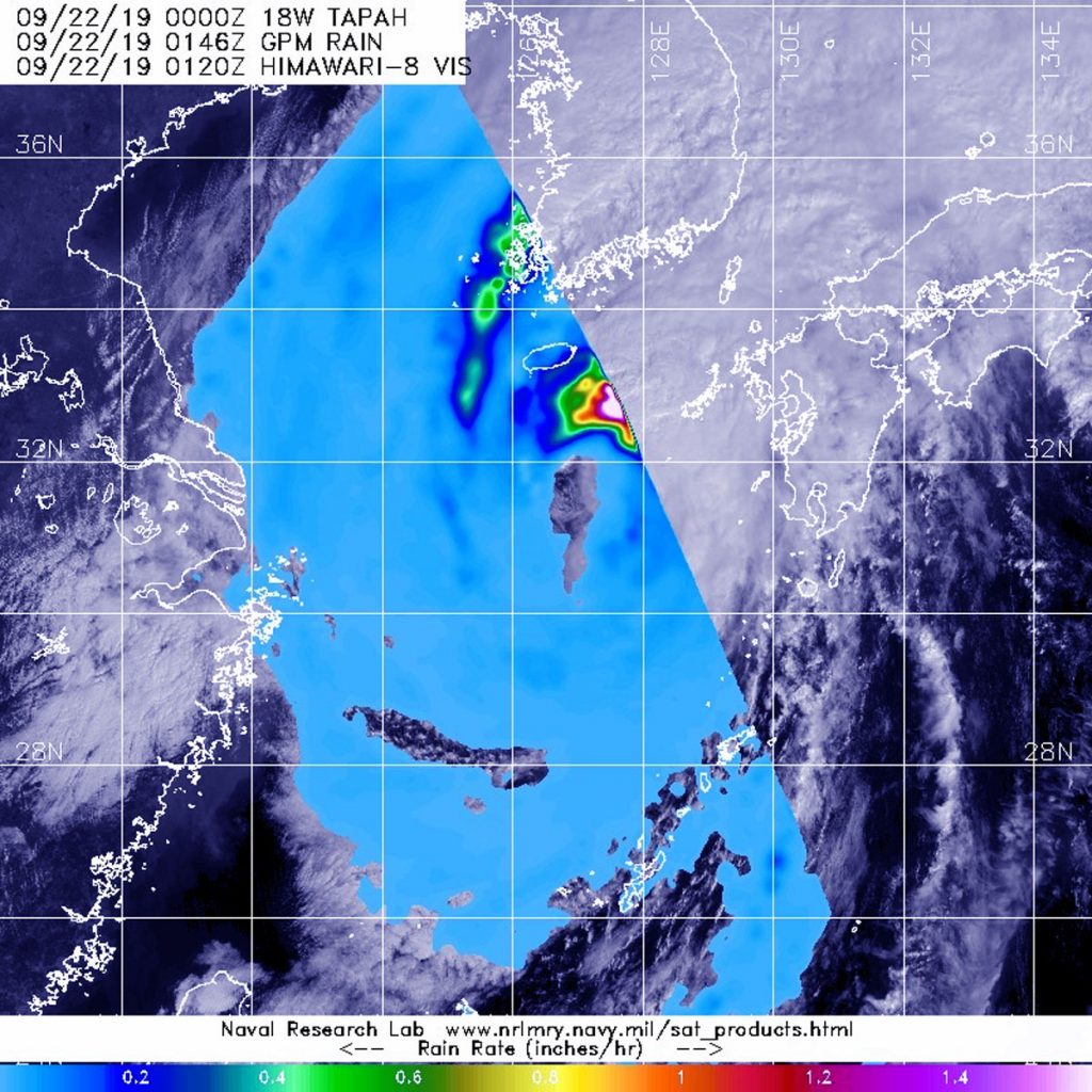
GPM image of Tapah
The GPM core satellite passed over transitioning Tropical Storm Tapah in the northwestern Pacific Ocean on Sept. 22 at 8:00 p.m. EDT (0000 UTC) and found the heaviest rainfall (pink) in the northeastern side of the storm falling at a rate of over 36 mm (about 1.4 inch) per hour. Credit: NASA/JAXA/NRL

GPM passed over Tapah on Sept. 22 at 0000 UTC (Sept. 21 at 8 p.m. EDT). GPM found the heaviest rainfall in the northeastern side of the storm, where it was falling at a rate of over 36 mm (about 1.4 inch) per hour. Heavy rainfall was also visible in a band of thunderstorms feeding into the center from the northeastern quadrant where rain was falling at a rate of 25 mm (1 inch) per hour. Rainfall around the rest of the storm was light. The storm also appeared elongated in GPM imagery which is an indication of a storm becoming extra-tropical.

That means that a tropical cyclone has lost its “tropical” characteristics. NOAA’s National Hurricane Center defines “extra-tropical” as a transition that implies both poleward displacement (meaning it moves toward the north or south pole) of the cyclone and the conversion of the cyclone’s primary energy source from the release of latent heat of condensation to baroclinic (the temperature contrast between warm and cold air masses) processes. It is important to note that cyclones can become extratropical and still retain winds of hurricane or tropical storm force.

As Tropical Storm Tapah was transitioning into an extra-tropical storm at 5 a.m. EDT (0900 UTC) on Sunday, Sept. 22, it was centered near 32.8 north latitude and 127.9 east longitude, about 97 miles west-southwest of Sasebo, Japan. Tapah was moving to the northeast and had maximum sustained winds near 55 knots (63 mph). That location was from the Joint Typhoon Warning Center’s final advisory on the system.

Hurricanes are the most powerful weather event on Earth. NASA’s expertise in space and scientific exploration contributes to essential services provided to the American people by other federal agencies, such as hurricane weather forecasting.

GPM is a joint mission between NASA and the Japan Aerospace Exploration Agency, JAXA.

For updated forecasts, visit: www.nhc.noaa.gov

By Rob Gutro
NASA’s Goddard Space Flight Center

Tapah – Northwestern Pacific Ocean

Sep. 20, 2019 – NASA Catches Tropical Storm Tapah by the Tail

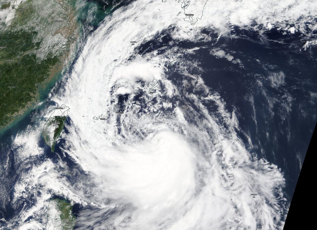
Tropical Storm Tapah has a huge “tail” on NASA satellite imagery. NASA’s Terra satellite captured an image of the northwestern Pacific Ocean storm that revealed a large band of thunderstorms that resemble a large tail. The NASA imagery also indicated that the storm is getting better organized.

Terra image of Tapah
On Sept. 19, the MODIS instrument that flies aboard NASA’s Terra satellite took this image of Tropical Storm Tapah. From the storm’s center a large band of thunderstorms resembling a tail extended from its western side, and stretched through the East China Sea and all the way north into the Sea of Japan. Credit: NASA Worldview

On Sept. 19, the Moderate Imaging Spectroradiometer or MODIS instrument that flies aboard NASA’s Terra satellite provided a visible image of Tapah. The image showed the center of the storm was a good distance east of Taiwan and the northern Philippines. From the storm’s center a large band of thunderstorms extended from its western side, and stretched through the East China Sea all the way north into the Sea of Japan. That large thunderstorm band made up Tapah’s “tail.”

The image also showed that there is a large band of powerful thunderstorms circling Tapah’s low-level center of circulation. The shape of the storm is a clue to forecasters that a storm is either strengthening or weakening. If a storm takes on a more rounded shape it is getting more organized and strengthening. Conversely, if it becomes less rounded or elongated, it is a sign the storm is weakening. Tapah has appeared to become more symmetrical in the MODIS imagery, indicating it is getting better organized.
At 11 a.m. EDT (1500 UTC) on Sept. 20, the center of Tropical Storm Tapah was located near latitude 24.6 degrees north and longitude 127.1 degrees east. That puts the center about 147 nautical miles south of Kadena Air Force Base, Okinawa, Japan. Maximum sustained winds were near 50 knots (57 mph/92 kph).

The Joint Typhoon Warning Center or JTWC noted that Tapah was moving to the north-northeast. JTWC uses satellite imagery in their forecasts and has indicated that Tapah is strengthening. The JTWC forecast takes Tapah on a curved path to the northwest then northeast and through the Sea of Japan over Sept. 22 and 23.

Hurricanes are the most powerful weather event on Earth. NASA’s expertise in space and scientific exploration contributes to essential services provided to the American people by other federal agencies, such as hurricane weather forecasting.

For updated forecasts, visit: https://www.nhc.noaa.gov

By Rob Gutro
NASA’s Goddard Space Flight Center

Tapah – Northwestern Pacific Ocean

Sep. 19, 2019 – NASA Analyzes Rainfall Rates in New Tropical Storm Tapah

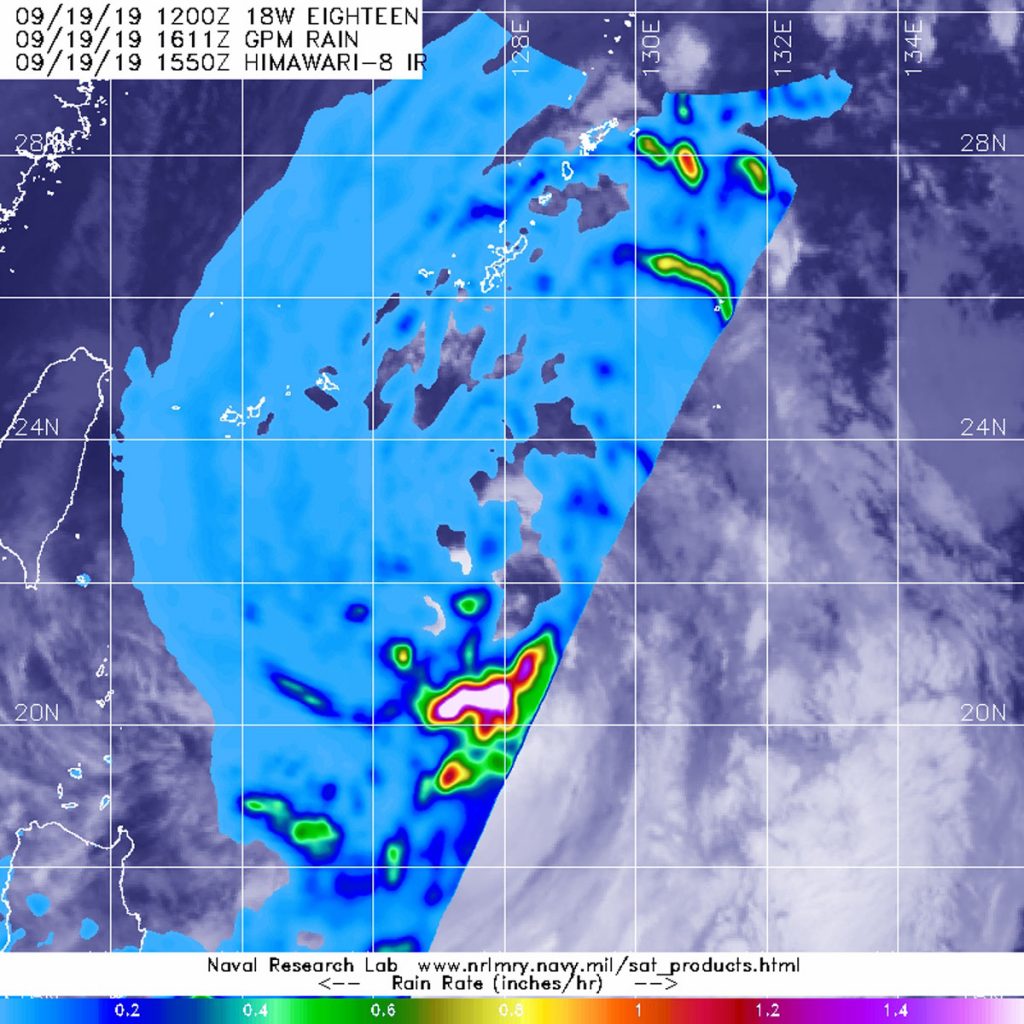
Tropical Storm Tapah formed quickly in the northwestern Pacific Ocean and as it was strengthening from a depression to a tropical storm, the Global Precipitation Measurement mission or GPM core satellite passed overhead from its orbit in space and measured rainfall rates throughout the storm.

GPM image of Tapah
The GPM core satellite passed over strengthening Tropical Storm Tapah in the northwestern Pacific Ocean on Sept. 16 at 12:11 p.m. EDT (1611 UTC) and found the heaviest rainfall (pink) falling at as much as 1.6 inches (40 mm) per hour. Credit: NASA/JAXA/NRL

NASA has the unique capability of peering under the clouds in storms and measuring the rate in which rain is falling. The GPM’s core satellite passed over Tropical Storm Tapah in the northwestern Pacific Ocean on Sept. 16 at 12:11 p.m. EDT (1611 UTC).

GPM found the heaviest rainfall around the storm’s center, where it was falling at a rate of as much as 1.6 inches (40 mm) per hour. Forecasters at the Joint Typhoon Warning Center incorporate the rainfall data into their forecasts.

Both the Japan Aerospace Exploration Agency (JAXA) and NASA manage GPM.

At 11 a.m. EDT (1500 UTC), the center of Tropical Storm Tapah was located near latitude 23.1 degrees north and longitude 127.9 degrees east. That puts Tapah’s center about 211 nautical miles south of Kadena Air Base, Okinawa, Japan. Maximum sustained winds remain near 40 mph (46 kph) with higher gusts. Tapah is forecast to strengthen but remain a tropical storm over the next several days.

Hurricanes are the most powerful weather event on Earth. NASA’s expertise in space and scientific exploration contributes to essential services provided to the American people by other federal agencies, such as hurricane weather forecasting.

For updated forecasts, visit: www.nhc.noaa.gov
By Rob Gutro
NASA’s Goddard Space Flight Center