Fernand (was TD7) – Atlantic Ocean/Gulf of Mexico

Sep. 05, 2019 – NASA Finds a Few Strong Storms Left in Fernand’s Remnants Over Northeastern Mexico

Tropical Storm Fernand made landfall in northeastern Mexico and began dissipating. However, infrared imagery from NASA’s Aqua satellite shows that there are still fragmented strong storms left in the tropical cyclone’s remnants. Those storms have the potential to generate heavy rainfall and there were warnings posted on Sept. 5.

Aqua image of Fernand
On Sept. 5 at 4:20 a.m. EDT (0820 UTC) the MODIS instrument that flies aboard NASA’s Aqua satellite showed strongest storms (red) in fragmented thunderstorms in the remnants of Fernand over northeastern Mexico. There, cloud top temperatures were as cold as minus 70 degrees Fahrenheit (minus 56.6 Celsius). Credit: NASA/NRL

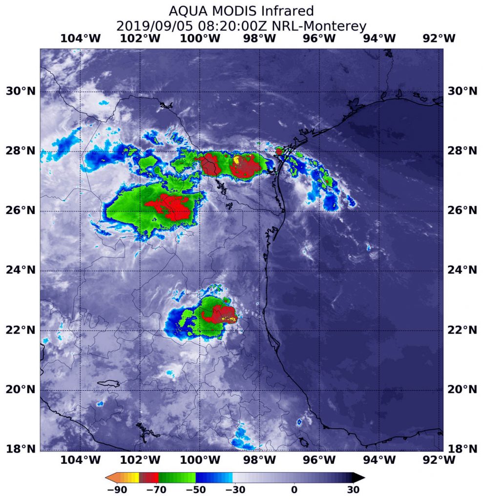
NASA’s Aqua satellite used infrared light to analyze the strength of storms in the remnants of Tropical Storm Fernand. Infrared data provides temperature information, and the strongest thunderstorms that reach high into the atmosphere have the coldest cloud top temperatures.

On Sept. 5 at 4:20 a.m. EDT (0820 UTC), the Moderate Imaging Spectroradiometer or MODIS instrument that flies aboard NASA’s Aqua satellite found strongest thunderstorms had cloud top temperatures as cold as minus 70 degrees Fahrenheit (minus 56.6 Celsius). Cloud top temperatures that cold indicate strong storms with the potential to generate heavy rainfall.

The Servicio Meteorológico Nacional (SMN) is Mexico’s national weather organization. On Sept. 5, SMN issued several warnings for rainfall from Fernand’s remnants. SMN forecasters expect rainfall will total up to 15 inches over northeastern Mexico. In Tamaulipas less than one additional inch is expected. However, in central and southern Nuevo Leon, another 3 to 6 inches is expected. In northern Nuevo Leon and southern Coahuila, 2 to 5 inches are forecasts, and south Texas and the lower Texas coast can expect between 1 to 2 inches, totalling 6 inches in that area.

NOAA’s National Hurricane Center (NHC) issued the final advisory on the remnants of Fernand at 0300 UTC on Sept. 5 (11 p.m. EDT on Sept. 4). At that time, the remnants were centered near 23.0 degrees north latitude and 99.0 degrees west longitude. That’s about 130 miles west-southwest of the mouth of the Rio Grande River. The remnants were moving to the west-northwest and the remnants had maximum sustained winds near 30 knots (34.5 mph/55.5 kph).

Fernand is expected to dissipate over the next day or two.

By Rob Gutro
NASA’s Goddard Space Flight Center

Fernand (was TD7) – Atlantic Ocean/Gulf of Mexico

Sep. 04, 2019 – NASA Analyzed Tropical Storm Fernand’s Strength Before Landfall

NASA’s Aqua satellite provided forecasters at the National Hurricane Center with infrared data and cloud top temperature information for Tropical Storm Fernand as it was making landfall in northeastern Mexico. Those temperatures indicated Fernand’s rainmaking capabilities. The infrared data also showed wind shear was affecting the storm.

AIRS image of Fernand
On Sept. 3, at 5:23 a.m. EDT (0923 UTC) the AIRS instrument aboard NASA’s Aqua satellite analyzed cloud top temperatures of Tropical Storm Fernand in infrared light. AIRS found coldest cloud top temperatures (purple) of strongest thunderstorms were as cold as or colder than minus 63 degrees Fahrenheit (minus 53 degrees Celsius) around the center and in a thick band of thunderstorms over northeastern Mexico. Credit: NASA JPL/Heidar Thrastarson

NASA researches tropical cyclones and infrared data is one of the ways NASA uses. Cloud top temperatures provide information to forecasters about where the strongest storms are located within a tropical cyclone. The stronger the storms, the higher they extend into the troposphere, and they have the colder cloud temperatures.

NASA’s Aqua satellite analyzed the storm on Sept. 3, at 5:23 a.m. EDT (0923 UTC) using the Atmospheric Infrared Sounder or AIRS instrument. AIRS found coldest cloud top temperatures as cold as or colder than minus 63 degrees Fahrenheit (minus 53 degrees Celsius) around the center and in a thick band of thunderstorms over northeastern Mexico. NASA research has shown that cloud top temperatures that cold indicate strong storms that have the capability to create heavy rain.

That heavy rainfall potential is apparent in the warnings posted today. In northeastern Mexico, from Tamaulipas and Central/Southern Nuevo Leon, 6 to 12 inches of rain are possible with isolated 18 inches, highest along the immediate Gulf Coast and in the Sierra Madre Oriental.  This rainfall may cause life-threatening flash floods and mudslides. Areas from Northern Nuevo Leon and Southern Coahuila can expect 3 to 6 inches. The south Texas and the lower Texas coast can also expect 2 to 4 inches, with isolated totals to 6 inches. In addition, a tornado or two are possible across far South Texas through this evening.

On Sept. 3, NOAA’s National Hurricane Center’s (NHC) discussion indicated that Fernand has been experiencing moderate easterly to southeasterly vertical wind shear and ingesting dry air in the southeastern semicircle. In general, wind shear is a measure of how the speed and direction of winds change with altitude.

That wind shear was indicated in the AIRS infrared imagery because the southeastern quadrant of Fernand appeared devoid of clouds. That’s an indication that outside winds from the east-southeast were pushing clouds and showers to the west-northwest of the center, where the AIRS imagery showed the bulk of clouds.

On Wednesday, September 4, 2019, a Tropical Storm Warning was in effect from Puerto Altamira to the Mouth of the Rio Grande River.

NHC noted at 8 a.m. EDT (1200 UTC), the center of Tropical Storm Fernand was located near latitude 23.5 North, longitude 97.2 West. Fernand is moving toward the west near 6 mph (9 kph). That puts the center of Fernand about 45 miles (70 km) southeast of La Pesca, Mexico. Maximum sustained winds are near 50 mph (85 kph) with higher gusts. Little change in strength is expected before the center moves onshore. The estimated minimum central pressure is 1000 millibars.

NHC said, “A motion toward the west or west-northwest is expected today, and the center of Fernand is forecast to cross the northeastern coast of Mexico later today or this evening. The cyclone is forecast to move inland over northeastern Mexico by this evening, and then dissipate quickly over the rugged terrain of the Sierra Madre Oriental mountains.”

For updated forecasts, visit: www.nhc.noaa.gov

For updated warnings from the Mexican Meteorological Service, visit: https://smn.conagua.gob.mx/es/

By Rob Gutro
NASA’s Goddard Space Flight Center  

TD7 – Atlantic Ocean

Sep. 03, 2019 – NASA Infrared Data Reveals Rainmaking Potential in Tropical Depression 7

 Another Atlantic Ocean basin depression formed while Hurricane Dorian is still wreaking havoc on the Bahamas and affecting the southeastern U.S. Infrared imagery from NASA’s Aqua satellite shows that Tropical Depression 7 in the western Gulf of Mexico has developed powerful thunderstorms with heavy rain capabilities. That potential for heavy rainfall includes southern Texas and northeastern Mexico.

MODIS image of TD7
On Sept. 3 at 4:30 a.m. EDT (0830 UTC) the MODIS instrument that flies aboard NASA’s Aqua satellite showed strongest storms (red) in fragmented thunderstorms around the center of Tropical Depression 7 in the western Gulf of Mexico. There, cloud top temperatures were as cold as minus 70 degrees Fahrenheit (minus 56.6 Celsius). Credit: NASA/NRL

NASA conducts research on tropical cyclones and provides various data to forecasters at NOAA’s National Hurricane Center (NHC) to consider in their forecasts.

NASA’s Aqua satellite used infrared light to analyze the strength of storms in Tropical Depression 7 and found strongest storms in fragmented bands of thunderstorms north and south of the center. The westernmost extent of those strong storms were already affecting the extreme northeastern coast of Mexico. Infrared data provides temperature information, and the strongest thunderstorms that reach high into the atmosphere have the coldest cloud top temperatures.

On Sept. 3 at 4:30 a.m. EDT (0830 UTC) the Moderate Imaging Spectroradiometer or MODIS instrument that flies aboard NASA’s Aqua satellite found strongest thunderstorms had cloud top temperatures as cold as minus 70 degrees Fahrenheit (minus 56.6 Celsius). Cloud top temperatures that cold indicate strong storms with the potential to generate heavy rainfall.

The NHC said the system is expected to produce the following rainfall totals through Friday:

In northeastern Mexico, 6 to 12 inches of rainfall is possible with isolated totals to 15 inches, highest in the Sierra Madre Oriental of Tamaulipas and Nuevo Leon. This rainfall may cause life-threatening mudslides and flash floods. In south Texas and the lower Texas Coast, 2 to 4 inches are possible with isolated amounts as high as 6 inches.

Tropical Depression 7 (TD7) formed around 5 a.m. EDT today, Sept. 3, 2019 and NHC posted a Tropical Storm Warning from La Pesca to Barra El Mezquital, Mexico.

NHC’s advisory at 11 a.m. EDT (1500 UTC) on Sept. 3 noted that the center of Tropical Depression Seven (TD7) was located near latitude 23.6 degrees north and longitude 94.9 degrees west.  The depression is moving toward the west near 7 mph (11 kph), and this motion is expected to continue today.

Maximum sustained winds are near 35 mph (55 km/h) with higher gusts. Slow strengthening is forecast before the system moves inland, and the depression is expected to become a tropical storm by Wednesday. The estimated minimum central pressure is 1004 millibars.

NHC forecasters said a motion toward the west-northwest is forecast tonight and Wednesday.  This motion could bring the system near or over the coast of northeastern Mexico late Wednesday.

For updated forecasts, visit: www.nhc.noaa.gov

By Rob Gutro
NASA’s Goddard Space Flight Center