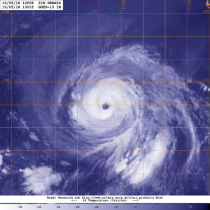
Oct. 05, 2018 – NOAA’s GOES-West Night-time View of Hurricane Sergio
Hurricane Sergio continued to look impressive on satellite imagery when NOAA’s GOES-West satellite viewed the storm in infrared light.

NOAA’s GOES-West satellite sits at a fixed position in orbit and covers the western U.S. and the Eastern and Central Pacific Ocean. GOES satellites circle the Earth in a geosynchronous orbit, which means they orbit the equatorial plane of the Earth at a speed matching the Earth’s rotation. This allows them to hover continuously over one position on the surface. NOAA’s GOES-West satellite provided a night-time view of powerful Hurricane Sergio on Oct. 5 at 6:01 a.m. PDT (9:01 a.m. EDT/1301 UTC) in the Eastern Pacific Ocean. The imagery showed that Sergio had a clear eye with powerful thunderstorms circling the center.
At 2 a.m. PDT (5 a.m. EDT/0900 UTC), the eye of Hurricane Sergio was located near latitude 16.0 degrees north and longitude 121.2 degrees west. Sergio is moving toward the west-northwest near 8 mph (13 kph). A turn toward the west and west-southwest at a similar speed is expected during the next 24 hours. Sergio should then turn back to the west and northwest over the weekend. Maximum sustained winds have decreased to near 120 mph (195 kph) with higher gusts. Sergio is a category 3 hurricane on the Saffir-Simpson Hurricane Wind Scale. Additional gradual weakening is forecast during the next several days, but Sergio is expected to remain a hurricane through the middle of next week.
NOAA manages the GOES series of satellites and the NASA/NOAA GOES Project at NASA’s Goddard Space Flight Center in Greenbelt, Maryland, is responsible for building and launching the GOES satellites.
For updated forecasts, visit: www.nhc.noaa.gov
