Oct. 11, 2018 #1 – NASA Eyes Hurricane Michael Moving Inland
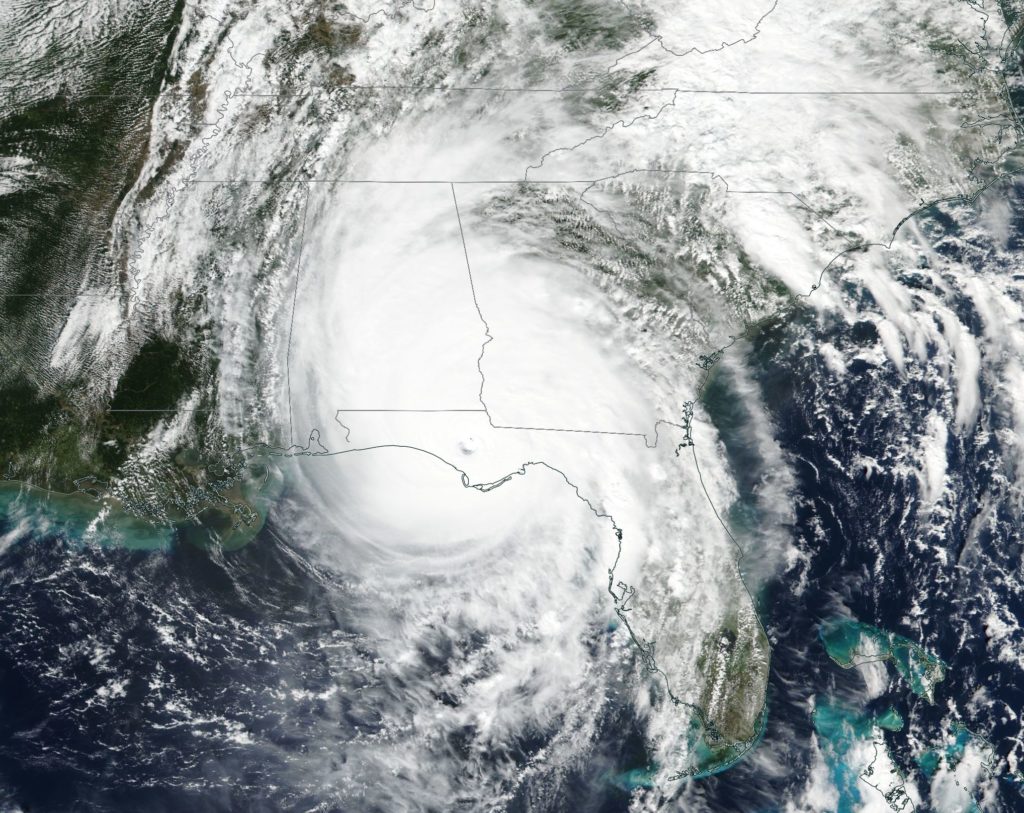
NASA’s Aqua satellite and NASA-NOAA’s Suomi NPP Satellite passed over the Florida Panhandle and captured different views of Hurricane Michael after it made landfall on Oct. 10. Hurricane Michael is the most powerful storm on record to hit the Florida Panhandle.
A Visible View of Michael
NASA-NOAA’s Suomi NPP satellite provided this visible image of Hurricane Michael after it made landfall in the Florida panhandle on Oct. 10. The image revealed high clouds over the eye, located in the panhandle. Michael’s extent covered Alabama, the western half of Georgia and the northern half of Florida.

Infrared View Shows Michael as a Powerful Rainmaker
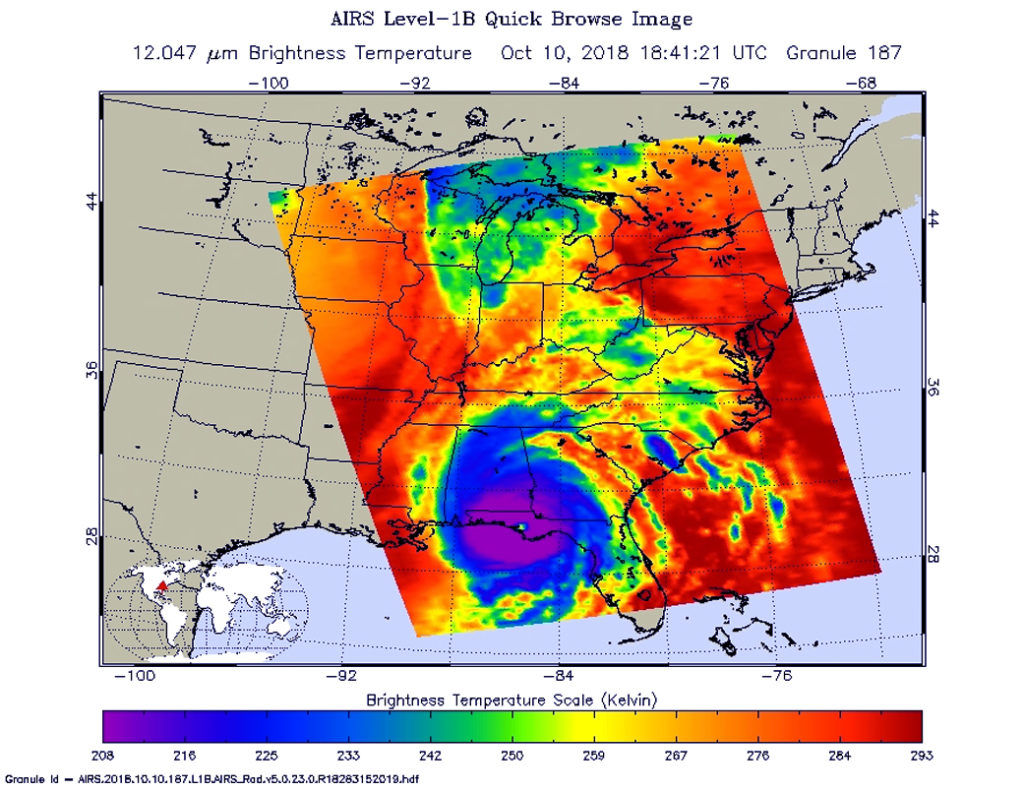
On Oct. 10 at 2:41 p.m. EDT (1841 UTC) the Atmospheric Infrared Sounder or AIRS instrument aboard NASA’s Aqua satellite provided an infrared view of Hurricane Michael after landfall. The AIRS image showed that Michael still maintained a clear eye, and was surrounded by a large symmetric area of powerful thunderstorms. Those powerful thunderstorms had cloud top temperatures near 208 kelvin (minus 85.2 degrees Fahrenheit/minus 65.1 degrees Celsius). NASA research has shown that cloud top temperatures that cold in storms indicate the storms have the capability to generate heavy rainfall.
That rainfall is a major concern. The NHC said “Michael is expected to produce total rain accumulations of 4 to 7 inches from eastern Georgia to the southern Mid-Atlantic States and 1 to 3 inches over the northern Mid-Atlantic States and coastal southern New England. Isolated maximum amounts of 9 inches are possible in North Carolina and Virginia. This rainfall could lead to life-threatening flash floods.”

Watches and Warnings in Effect
On Oct. 11, a Storm Surge Watch is in effect for Ocracoke Inlet, North Carolina to Duck, North Carolina and a Tropical Storm Warning is in effect from Altamaha Sound, Georgia to Duck, North Carolina and the Pamlico and Albemarle Sounds.
Where’s Michael on Oct. 11?
On Oct. 11 at 8 a.m. EDT, the National Hurricane Center (NHC) noted that the center of Michael moving over South Carolina and that tropical-storm-force winds were occurring over portions of southeastern Georgia and central and eastern South Carolina. Michael’s center at the time was about 40 miles (65 km) west-northwest of Columbia, South Carolina.
At 8 a.m. EDT (1200 UTC), the center of Tropical Storm Michael was located near latitude 34.1 degrees north, and longitude 81.8 degrees west. NHC said “Michael is moving toward the northeast near 21 mph (33 kph) and this motion is expected to continue with an increase in forward speed through tonight. A turn toward the east-northeast and an even faster forward speed are expected on Friday. On the forecast track, the center of Michael will continue to move across central South Carolina this morning, then move across portions of central and eastern North Carolina and southeastern Virginia this afternoon and this evening, and move into the Atlantic Ocean by late tonight or early Friday.”
Maximum sustained winds are near 50 mph (85 kph) with higher gusts. Little change in strength is expected today, with the strongest winds primarily spreading northward along the coast of the Carolinas.
Where Michael is Going
NHC forecaster Jack Beven noted “There is currently a small area of tropical-storm-force winds near the center, with a second area over the Atlantic well to the southeast of the center. Michael should continue to weaken for the next 12 hours or so as the center moves through South Carolina and into North Carolina. After that time, the cyclone should start to intensify due to baroclinic forcing, and it is expected to become a gale- or storm-force extratropical low around the 24-hour point.”
Michael is forecast to intensify as it becomes a post-tropical low over the Atlantic late tonight or early Friday, Oct. 12.
For details on Michael’s storm surge, rainfall, winds and tornadoes, visit: www.nhc.noaa.gov
