Oct. 23, 2018 – NASA Eyes Powerful Hurricane Willa Affecting Western Mexico
NASA’s Aqua satellite provided an infrared view of Hurricane Willa as it continued moving toward landfall in western Mexico on Oct. 23. NASA-NOAA’s Suomi NPP satellite provided a visible look at the extent and structure of the storm. Willa is expected to bring life-threatening storm surge, wind, and rainfall to portions of west-central and southwestern Mexico.
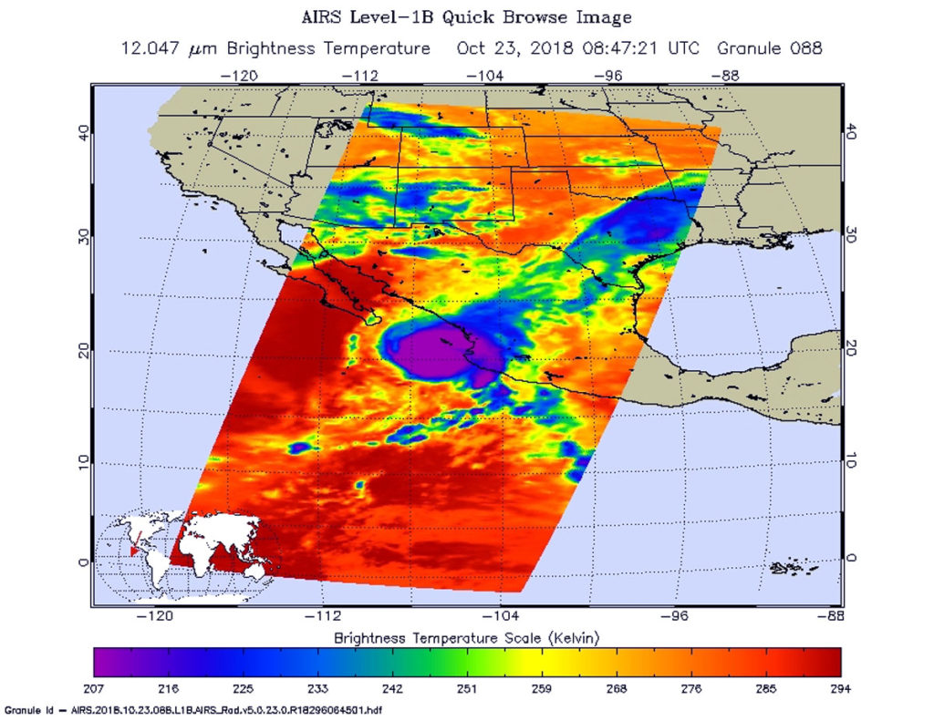
NASA Satellite Imagery Reveal
On Oct. 22, NASA-NOAA’s Suomi NPP satellite captured a visible image of Hurricane Willa when it was battering western Mexico with heavy rainfall, rough surf and strong winds. The image showed powerful thunderstorms circling a cloud-filled eye and the storm stretched from Sinaloa state south to Michoacan state.
NASA’s Aqua satellite passed over Hurricane Willa on Oct. 23 at 4:47 a.m. EDT (0847 UTC) and the Atmospheric Infrared Sounder or AIRS instrument aboard analyzed cloud top temperatures using infrared light. Coldest cloud top temperatures were as cold as or colder than 208 Kelvin or minus 85.2 degrees Fahrenheit (minus 65.1 Celsius). Cloud top temperatures that cold indicate strong storms that have the capability to create heavy rain.
Watches and Warnings on Oct. 23, 2018
A Hurricane Warning is in effect for San Blas to Mazatlan, including Las Islas Marias. A Tropical Storm Warning is in effect for Playa Perula to San Blas and north of Mazatlan to Bahia Tempehuaya.

Status of Hurricane Willa on Oct. 23 at 11 a.m. EDT
At 11 a.m. EDT on Oct. 23, NOAA Hurricane Hunter Aircraft found that the center of Hurricane Willa was passing over Las Islas Marias, Mexico. The center of Hurricane Willa was located near latitude 21.4 degrees north and longitude 106.9 degrees west. Willa is moving toward the north-northeast near 6 mph (9 kph). A faster motion toward the northeast is expected by this evening. Maximum sustained winds are near 125 mph (205 kph) with higher gusts. Willa is a category 3 hurricane on the Saffir-Simpson Hurricane Wind Scale. Hurricane-force winds extend outward up to 40 miles (65 km) from the center and tropical-storm-force winds extend outward up to 125 miles (205 km).
The National Hurricane Center noted “While gradual weakening is forecast today, Willa is expected to be a dangerous hurricane when it reaches the coast of Mexico. Rapid weakening is expected after landfall tonight and continuing into Wednesday (Oct. 24).
On the forecast track, the center of Willa will make landfall within the hurricane warning area along the west-central coast of mainland Mexico this evening.”
For updated forecasts, visit: www.nhc.noaa.gov