Oct. 31, 2018 -NASA’s CloudSat Gets a Slice of Typhoon Yutu’s Eye
NASA’s CloudSat satellite captured a stunning image of Typhoon Yutu as it passed over the eye of the storm. The storm has since weakened to a tropical storm.
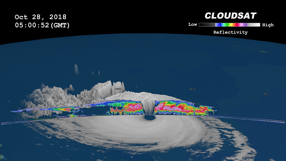
CloudSat flew over the eye of Typhoon Yutu on October 28, 2018 at 12:58 a.m. EDT (0458 UTC) as the storm was approaching the Philippines in the Western North Pacific. At the time of the CloudSat overpass, Typhoon Yutu was beginning a period of weakening as the storm was moving info less favorable atmospheric conditions (lower sea surface temperatures). Typhoon Yutu contained estimated sustained winds of 120 knots (138 mph) with a minimum pressure of 933 millibars (the equivalent of a Category 4 strength storm). Typhoon Yutu left a trail of destruction through Saipan, Tinian and the Mariana Islands on October 24 and 25, 2018 as a Super Typhoon (category 5 strength storm).
Natalie Tourville of Colorado State University who produced the images, said “CloudSat’s 94 GHz cloud profiling radar (CPR) passed directly over the eye of Typhoon Yutu revealing the cirrus free eye with an outward sloping eyewall, a feature typically found in intense tropical systems. The southern portion of the eyewall appears more disorganized as the thicker cloud tops are starting to disintegrate from the top down.
The CloudSat overpass reveals the inner details beneath the storms cloud tops. Intense areas of convection with moderate to heavy rainfall, cloud-free areas (moats) underneath the northern portion of the cirrus canopy and cloud top height’s estimated at 14 kilometers (8.7 miles). Lower values of reflectivity denote smaller ice and water particle sizes typically located at top of the system (in the anvil area). The CloudSat CPR signal attenuates in heavy rainfall when cloud droplets become larger than 3 millimeters (.11 inch) which dampen the strength of the CPR signal. This is evident by the lack of signal typically occurring beneath the melting level when frozen particles transform into liquid.”
On Oct. 31 at 5 a.m. EDT (0900 UTC) Yutu had weakened to a tropical storm with maximum sustained winds near 45 knots (52 mph/83 kph). Tropical storm Yutu was centered near 18.1 degrees north latitude and 117.5 degrees east longitude, about 291 nautical miles northwest of Manila, Philippines.
As Yutu moves toward China, Hong Kong has posted Stand-by signal #1. The Joint Typhoon Warning Center expects Yutu to re-strengthen as it moves north. The storm is forecast to dissipate off the Chinese mainland, east of Hong Kong.