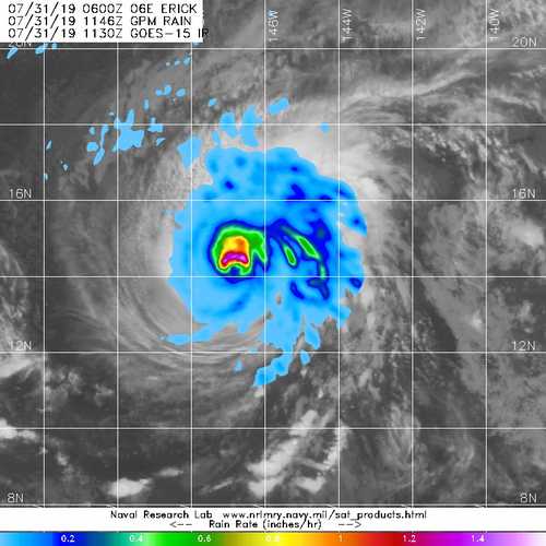
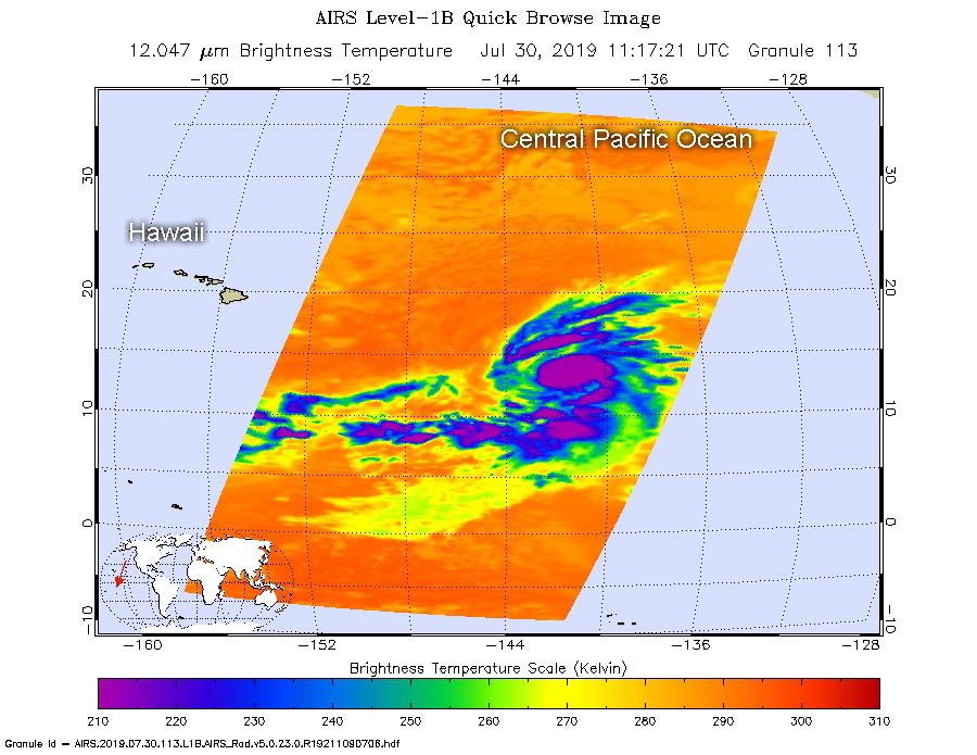
July 31, 2019 – NASA Finds Heavy Rain in Hurricane Erick
NASA provided forecasters with a look at Hurricane Erick’s rainfall rates and cloud temperatures with data from the GPM and Aqua satellites, as the storm headed to Hawaii.
Erick is a major hurricane in the Eastern Pacific Ocean and is a category 3 hurricane on the Saffir-Simpson Hurricane Wind Scale.
NASA’s Aqua satellite analyzed Erick on July 30 at 7:17 a.m. EDT (1117 UTC) using the Atmospheric Infrared Sounder or AIRS instrument. The stronger the storms, the higher they extend into the troposphere, and they have the colder cloud temperatures. AIRS found coldest cloud top temperatures as cold as or colder than minus 63 degrees Fahrenheit (minus 53 degrees Celsius) in a large area around the center.
The Global Precipitation Measurement mission or GPM core satellite passed over Hurricane Erick at 7:46 a.m. EDT (1146 UTC) on July 31. GPM found the heaviest rainfall was around the northern eyewall of the center of circulation. There, rain was falling at a rate of over 40 mm (about 1.6 inches) per hour. GPM is a joint mission between NASA and the Japan Aerospace Exploration Agency, JAXA.
The National Hurricane Center (NHC) said at 11 a.m. EDT (5 a.m. HST/1500 UTC), the center of Hurricane Erick was located near latitude 14.5 North, longitude 147.5 West. Erick is moving toward the west near 13 mph (20 kph) and this motion is expected to continue for the next 48 hours. Maximum sustained winds are near 120 mph (195 kph) with higher gusts. Some weakening is forecast during the next 48 hours. The estimated minimum central pressure is 958 millibars.
NHC noted “Swells generated by Erick will arrive in the Hawaiian Islands over the next couple of days, potentially producing dangerous surf conditions, mainly along east facing shores. Moisture associated with Erick will spread over the Hawaiian Islands by Thursday afternoon [Aug. 1] and produce heavy rainfall. Rainfall is expected to be heaviest over the east and southeast slopes of the Big Island of Hawaii.”
For forecast updates, visit: www.nhc.noaa.gov.