Aug. 02, 2019 – NOAA Finds Tropical Storm Erick’s Center With Help of Two NASA Satellites
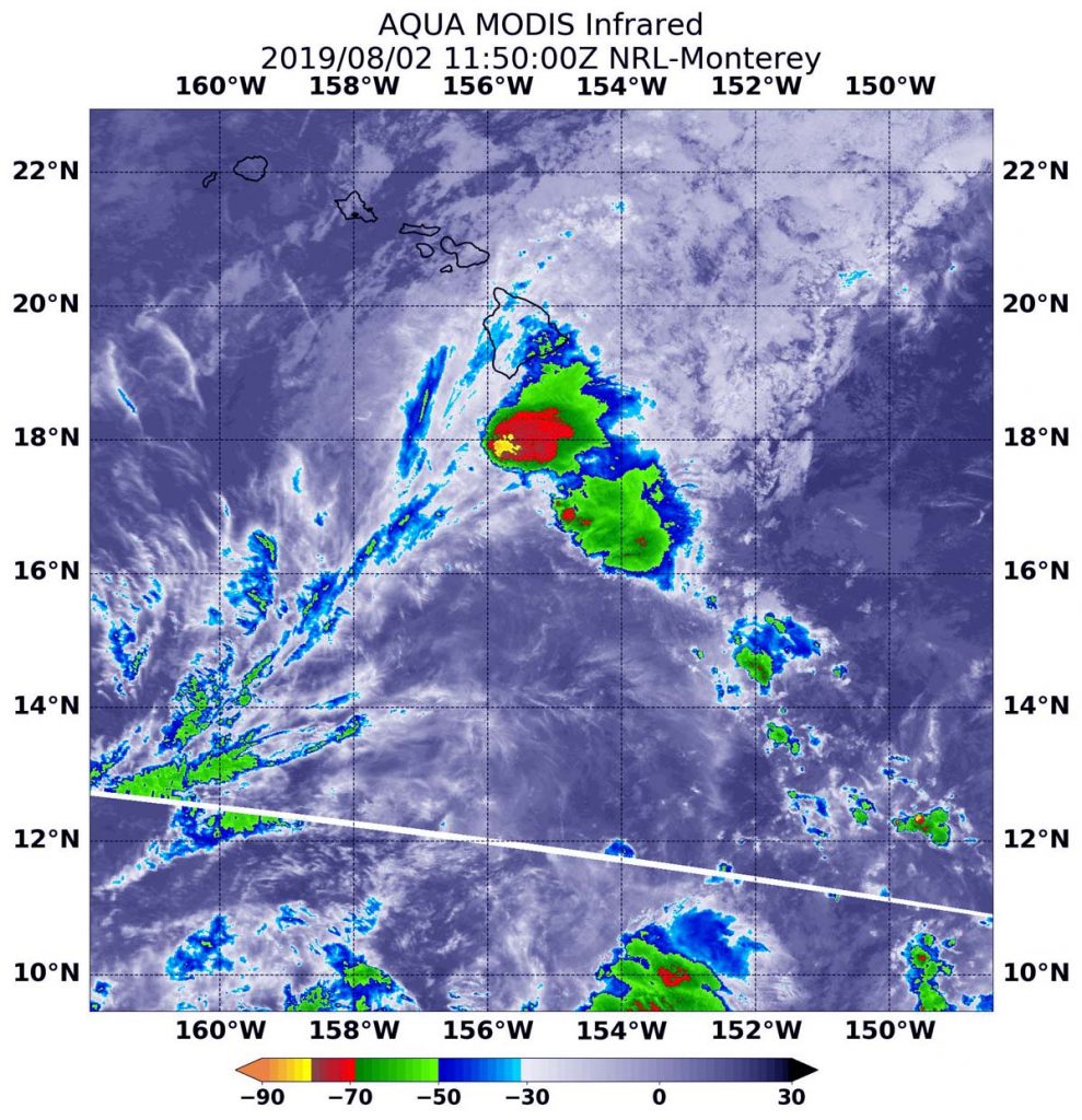
Infrared imagery from NASA’s Aqua satellite revealed Tropical Storm Erick is being battered by wind shear, and that its strongest storms were south of the Big Island of Hawaii. NOAA forecasters used other NASA satellites to find Erick’s center.

In the National Hurricane Center (NHC) Discussion of Erick on August 2 at 11 a.m. EDT (1500 UTC), Forecaster Jelsema noted that the NHC utilized data from two NASA satellites to find Erick’s center. The Discussion noted “Although the center was difficult to locate overnight due to high level cloud cover moving over the low-level center of circulation, a timely GPM (Global Precipitation Measurement mission) pass at 7:36 a.m. EDT (1136Z) and a Visible Infrared Imaging Radiometer Suite (VIIRS) pass at 7:40 a.m. EDT (1140Z) assisted in locating the center.” VIIRS is an instrument aboard NASA-NOAA’s Suomi NPP satellite.
In addition, NASA’s Aqua satellite used infrared light to analyze the strength of storms and found the bulk of them in the southwestern quadrant of Erick, and south of the Big Island of Hawaii. Infrared data provides temperature information, and the strongest thunderstorms that reach high into the atmosphere have the coldest cloud top temperatures. Cloud top temperatures that cold indicate strong storms with the potential to generate heavy rainfall. Those strongest storms were south and southeast of the center of the elongated circulation.
On August 2 at 7:50 a.m. EDT (1150 UTC), the Moderate Imaging Spectroradiometer or MODIS instrument that flies aboard NASA’s Aqua satellite found those strongest storms had cloud top temperatures as cold as minus 80 degrees Fahrenheit (minus 62.2 Celsius).
NHC noted that “Deep convection has managed to develop over the low level circulation center (LLCC) of Erick this morning, after the center was exposed for much of the night. Strong west-southwesterly vertical wind shear continues to affect the tropical cyclone.”
At 11 a.m. EDT (5 a.m. HST/1500 UTC), the center of Tropical Storm Erick was located near latitude 16.8 degrees north latitude and 157.4 degrees west longitude. That’s about 250 miles (405 km) southwest of Hilo, Hawaii. Erick is moving toward the west-northwest near 14 mph (22 kph) and this general motion is expected to continue through tonight. A turn toward the northwest and a decrease in forward speed is expected over the weekend. On the forecast track, the center of Erick will pass by well to the south of the main Hawaiian Islands today and tonight. The estimated minimum central pressure is 1,000 millibars.
Maximum sustained winds are near 50 mph (85 kph) with higher gusts. Some gradual weakening is forecast during the next couple days. Erick is expected to become a tropical depression by Sunday, and a post-tropical remnant low Sunday night.
Swells generated by Erick will continue to affect the Hawaiian Islands today, producing dangerous surf conditions, mainly along east and southeast facing shores. In addition, rain associated with Erick will continue to spread over portions of the Hawaiian Islands through early Saturday (Aug. 3), bringing the potential for localized heavy rainfall. Total rainfall amounts of 4 to 8 inches are possible, with localized higher amounts.
Erick is forecast to weaken into a tropical depression by Sunday, and become a post-tropical remnant low Sunday night. Dissipation into a trough (elongated area of low pressure) is now forecast to occur by Monday night.
For updated forecasts, visit: https://www.nhc.noaa.gov
