Sep. 30, 2019 – NASA Finds Tropical Storm Narda Bringing Heavy Rainfall to Western Mexico
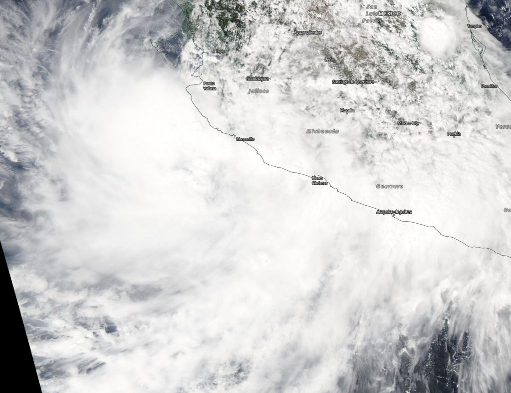
NASA’s Aqua satellite captured an image of Tropical Storm Narda along Mexico’s west coast in the Eastern Pacific Ocean. Satellite data revealed the potential for heavy rainfall within Narda, and warnings are in effect for portions of western Mexico.
Narda formed as Tropical Depression 16E on Saturday, Sept. 28 and intensified into a tropical storm late in the day. When it became a tropical storm it was renamed “Narda.”
On Sept. 30, the Moderate Imaging Spectroradiometer or MODIS instrument that flies aboard NASA’s Aqua satellite provided a visible image of Narda. The MODIS image showed the cyclone continues to produce a large area of deep convection near and to the west of its center. Earlier in the day, at 5 a.m. EDT, infrared satellite data showed that Narda continued to produce very intense deep convection (strong thunderstorms) with cloud tops colder than minus 80 degrees Celsius (minus 112 degrees Fahrenheit). NASA research has shown that storms with cloud top temperatures that cold can produce heavy rainfall.
That heavy rainfall potential is incorporated into the forecast for Sept. 30 from NOAA’s National Hurricane Center (NHC). Narda is expected to produce the following rainfall accumulations through Tuesday: Nayarit, Sinaloa…Additional 3 to 6 inches, isolated storm totals 10 to 15 inches. Jalisco, Colima, Michoacan…Additional 1 to 3 inches, isolated storm totals 10 to 15 inches. Chihuahua…1 to 3 inches. Baja California Sur, Sonora…1 to 2 inches.
At 11 a.m. EDT (1500 UTC), a Tropical Storm Warning is in effect from San Blas to Guaymas, and Islas Marias, Mexico.
The center of Tropical Storm Narda was located near latitude 22.5 degrees north and longitude 106.4 degrees west. That’s about 50 miles (80 km) south of Mazatlan, Mexico. NHC said recent microwave data and surface observations from Mexico indicate that the center of Narda is located just offshore of the west coast of mainland Mexico, north of Islas Marias.
Narda is moving toward the northwest near 15 mph (24 kph), and this general motion is expected to continue with some decrease in forward speed during the next couple of days. Maximum sustained winds are near 40 mph (65 kph) with higher gusts. Some slight strengthening is possible today. Weakening should begin by Tuesday as Narda interacts with the mountains of western Mexico. Tropical storm-force winds extend outward up to 45 miles (75 km) from the center. A wind gust to 44 mph (70 kph) was recently reported at San Blas, Mexico. The estimated minimum central pressure is 1000 millibars.
On the forecast track, the center of Narda will move over the Gulf of California near the coast of northwestern mainland Mexico through Tuesday, Oct. 1.
NASA’s Aqua satellite is one in a fleet of NASA satellites that provide data for hurricane research.
Hurricanes are the most powerful weather event on Earth. NASA’s expertise in space and scientific exploration contributes to essential services provided to the American people by other federal agencies, such as hurricane weather forecasting.
For updated forecasts, visit: https://www.nhc.noaa.gov