Late Dec. 2018 – Jan. 08, 2019 – Tropical Storm Penny Tracked Through Southwestern Pacific Ocean
Several satellites provided imagery on Tropical Storm Penny in the Southwestern Pacific Ocean. NASA-NOAA’s Suomi NPP satellite captured a visible image of the storm after it developed an eye.
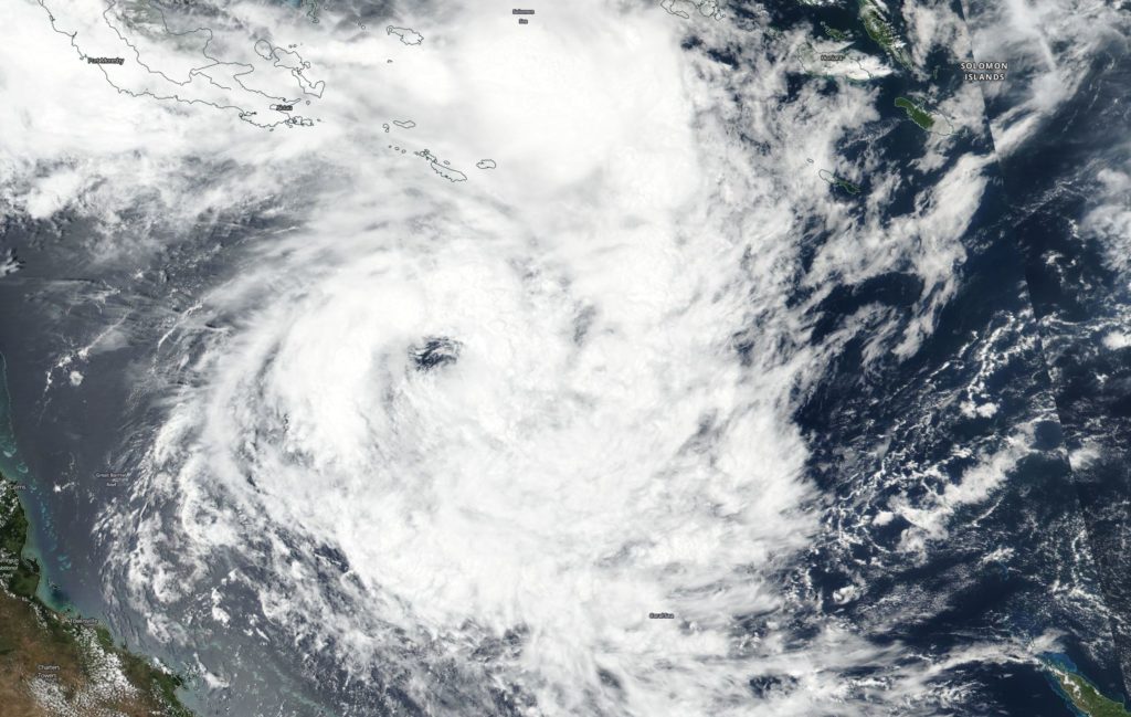
On January 3, 2019 Suomi NPP captured an image of Tropical Cyclone Penny in the Southwestern Pacific Ocean. Penny had developed an eye. Credit: NASA Worldview, Earth Observing System Data and Information System (EOSDIS)
Tropical cyclone Penny / 08P formed in late December, 2018 and It strengthened into a tropical storm. By January 3, 2019 at 4 a.m. EST (0900 UTC) Penny had strengthened to 40 knots. It was located near 15.0 degrees south latitude and 153.7 degrees east longitude, about 470 miles east-northeast of Cairns, Australia. Penny was moving to the east-southeast.
On January 3, 2019 Suomi NPP captured an image of Tropical Cyclone Penny in the Southwestern Pacific Ocean. Penny had developed an eye as it was moving across the Coral Sea.
The next day at 4 a.m. EST (0900 UTC) Penny’s maximum sustained winds increased to 50 knots. By January 7, at 10 a.m. EST (1500 UTC) Penny was 347 miles east-southeast of Cairns, Australia and winds had decreased to 50 knots. Penny was moving west across the Coral Sea and on January 8, the Joint Typhoon Warning Center issued the final warning on the system as it was dissipating.
Dec. 26 – 29, 2018 – NASA Finds Soaking Storms in 35W that Affected the Philippines
Tropical Depression 35W brought heavy rainfall and flooding to the Bicol and Eastern Visayas regions of the Philippines in late December 2018. Infrared imagery from NASA’s Aqua satellite found very cold cloud top temperatures in 35W, indicating powerful rain-making storms.
On Dec. 26, 2018 at 12:10 p.m. EST (1710 UTC) NASA’s Aqua satellite passed over the Northwestern Pacific Ocean and the MODIS instrument captured an infrared image of Tropical Depression 36W. MODIS found some very powerful thunderstorms with cloud tops as cold as minus 90 degrees Fahrenheit (green). Credit: NASA/NRL
Locally in the Philippines, Tropical Depression 35W was known as Usman. On Dec. 26, Tropical Depression 35W had triggered warnings in the Philippines. Tropical cyclone warning signal #1 was in force in Eastern Samar in the Visayas region. At 10 a.m. EST (1500 UTC) 35W was located near 10.0 degrees north latitude and 130.6 degrees east longitude, about 627 miles east-southeast of Manila, Philippines. 35W was moving to the west and at that time had maximum sustained winds near 25 knots (28.7 mph/46.3 kph).
On Dec. 26, 2018 at 12:10 p.m. EST (1710 UTC) NASA’s Aqua satellite passed over the Northwestern Pacific Ocean and the MODIS instrument captured an infrared image of Tropical Depression 35W. MODIS found some very powerful thunderstorms with cloud tops as cold as minus 90 degrees Fahrenheit (minus 67.7 degrees Celsius). NASA research has shown that cloud tops with temperatures that cold can generate very heavy rainfall.
On Dec. 27 at 4 a.m. EST (0900 UTC), Tropical Depression 35W was about 579 nautical miles east-southwest of Manila, Philippines. It was centered near 10.4 degrees north latitude and 129.9 degrees east longitude. 35W was moving west-northwest and maintained maximum sustained winds near 25 knots (28.7 mph/46.3 kph).
Philippines warnings were expanded on Dec. 27 to include: Tropical cyclone warning signal # in the Luzon provinces of Romblon, Catanduanes, Camarines Sur, Albay, Sorsogon, Masbate and Ticao Island; in the Visayas provinces of Eastern and Northern Samar as well as Samar, Biliran, Leyte, Southern Leyte and northern Cebu including Camotes Islands, Aklan, Capiz, northern Iloilo and northern Negros Occidental; and in the Mindanao province of Dinagat Island
35W moved west and made landfall on Dec. 29. It crossed the central Philippines where it dropped heavy rainfall, and created flooding and landslides. 61 people were reported killed from the flooding on Dec. 31. Tropical Depression 35W moved into the South China Sea where it dissipated.