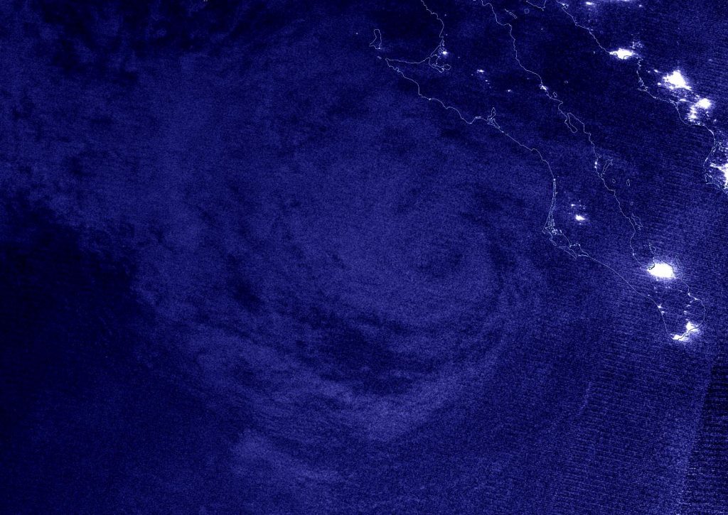
Aug. 21, 2020 – NASA Nighttime Image Shows a Weaker Genevieve Moving Away from Mexico
Nighttime imagery from NASA-NOAA’s Suomi NPP satellite found the center of now Tropical Storm Genevieve moving along the coast of the Baja California, Mexico peninsula and further away from land. The storm is weakening rapidly from several factors. It is expected to be a remnant low-pressure area by Saturday, Aug. 21.

On Aug. 20, the government of Mexico has discontinued the Tropical Storm Warning for the west coast of the Baja California peninsula.
NASA’s Night-Time View of Genevieve
Hurricane Genevieve weakened to a tropical storm and nighttime satellite imagery showed the structure of the storm had become more disorganized over the previous 24 hours. The Visible Infrared Imaging Radiometer Suite (VIIRS) instrument aboard Suomi NPP provided a nighttime image of Genevieve during the early morning hours of Aug. 20 at 4:14 a.m. EDT (0818 UTC). Nighttime imagery from NASA-NOAA’s Suomi NPP satellite was created using the NASA Worldview application at NASA’s Goddard Space Flight Center in Greenbelt, Md.
NOAA’s National Hurricane Center (NHC) Senior Hurricane Specialist Stacy Stewart noted, “The combination of moderate southerly vertical wind shear, cooler sea-surface temperatures near 26 degrees Celsius (78.8 degrees Fahrenheit), and dry mid-level air has caused Genevieve to rapidly weaken over the past 24 hours. Very little deep convection remains, and what convection there is has been displaced well to the northeast of the low-level center.”
Genevieve’s Status on Aug. 21
At 8 a.m. EDT (1500 UTC) on Aug. 21, the National Hurricane Center (NHC) noted the center of Tropical Storm Genevieve was located near latitude 24.6 degrees north and longitude 114.6 degrees west. That is about 145 miles (235 km) west of Cabo San Lazaro, Mexico.
Genevieve was moving toward the west-northwest near 9 mph (15 kph), and this general motion is expected to continue during the next few days. Maximum sustained winds have decreased to near 45 mph (75 kph) with higher gusts. The estimated minimum central pressure is 1001 millibars.
On the forecast track, the center of Genevieve will move farther away from the Baja California peninsula. Continued weakening is expected, and Genevieve is forecast to degenerate into a post-tropical cyclone later today.
About NASA’s EOSDIS Worldview
NASA’s Earth Observing System Data and Information System (EOSDIS) Worldview application provides the capability to interactively browse over 700 global, full-resolution satellite imagery layers and then download the underlying data. Many of the available imagery layers are updated within three hours of observation, essentially showing the entire Earth as it looks “right now.”
NASA Researches Earth from Space
For more than five decades, NASA has used the vantage point of space to understand and explore our home planet, improve lives and safeguard our future. NASA brings together technology, science, and unique global Earth observations to provide societal benefits and strengthen our nation. Advancing knowledge of our home planet contributes directly to America’s leadership in space and scientific exploration.
For updated forecasts, visit: www.nhc.noaa.gov
