Genevieve – Eastern Pacific Ocean

Aug. 21, 2020 – NASA Nighttime Image Shows a Weaker Genevieve Moving Away from Mexico

Nighttime imagery from NASA-NOAA’s Suomi NPP satellite found the center of now Tropical Storm Genevieve moving along the coast of the Baja California, Mexico peninsula and further away from land. The storm is weakening rapidly from several factors. It is expected to be a remnant low-pressure area by Saturday, Aug. 21.
Suomi NPP image of Genevieve
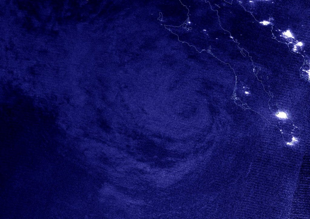
NASA-NOAA’s Suomi NPP satellite passed the Eastern Pacific Ocean overnight on Aug. 20 at 4:14 a.m. EDT (0818 UTC) and captured a nighttime image of Tropical Storm Genevieve. The image showed Genevieve moving northwest along the coast of Baja California, Mexico. Credit: NASA Worldview, Earth Observing System Data and Information System (EOSDIS)

On Aug. 20, the government of Mexico has discontinued the Tropical Storm Warning for the west coast of the Baja California peninsula.

NASA’s Night-Time View of Genevieve

Hurricane Genevieve weakened to a tropical storm and nighttime satellite imagery showed the structure of the storm had become more disorganized over the previous 24 hours. The Visible Infrared Imaging Radiometer Suite (VIIRS) instrument aboard Suomi NPP provided a nighttime image of Genevieve during the early morning hours of Aug. 20 at 4:14 a.m. EDT (0818 UTC). Nighttime imagery from NASA-NOAA’s Suomi NPP satellite was created using the NASA Worldview application at NASA’s Goddard Space Flight Center in Greenbelt, Md.

NOAA’s National Hurricane Center (NHC) Senior Hurricane Specialist Stacy Stewart noted, “The combination of moderate southerly vertical wind shear, cooler sea-surface temperatures near 26 degrees Celsius (78.8 degrees Fahrenheit), and dry mid-level air has caused Genevieve to rapidly weaken over the past 24 hours.  Very little deep convection remains, and what convection there is has been displaced well to the northeast of the low-level center.”

Genevieve’s Status on Aug. 21

At 8 a.m. EDT (1500 UTC) on Aug. 21, the National Hurricane Center (NHC) noted the center of Tropical Storm Genevieve was located near latitude 24.6 degrees north and longitude 114.6 degrees west. That is about 145 miles (235 km) west of Cabo San Lazaro, Mexico.

Genevieve was moving toward the west-northwest near 9 mph (15 kph), and this general motion is expected to continue during the next few days. Maximum sustained winds have decreased to near 45 mph (75 kph) with higher gusts. The estimated minimum central pressure is 1001 millibars.

On the forecast track, the center of Genevieve will move farther away from the Baja California peninsula. Continued weakening is expected, and Genevieve is forecast to degenerate into a post-tropical cyclone later today.

About NASA’s EOSDIS Worldview

NASA’s Earth Observing System Data and Information System (EOSDIS) Worldview application provides the capability to interactively browse over 700 global, full-resolution satellite imagery layers and then download the underlying data. Many of the available imagery layers are updated within three hours of observation, essentially showing the entire Earth as it looks “right now.”

NASA Researches Earth from Space

For more than five decades, NASA has used the vantage point of space to understand and explore our home planet, improve lives and safeguard our future. NASA brings together technology, science, and unique global Earth observations to provide societal benefits and strengthen our nation. Advancing knowledge of our home planet contributes directly to America’s leadership in space and scientific exploration.

For updated forecasts, visit: www.nhc.noaa.gov

By Rob Gutro 
NASA’s Goddard Space Flight Center

Genevieve – Eastern Pacific Ocean

Aug. 20, 2020 – NASA Gets a Wide Angle View of Hurricane Genevieve

NASA provided a series of photos of Hurricane Genevieve as it affected Mexico’s southern Baja California peninsula. An astronaut aboard the International Space Station provided wide-angle photos of Genevieve, showing the size of the storm. Warnings and watches are in effect on Aug. 20.

ISS image of Genevieve
International Space Station Astronaut Chris Cassidy snapped photos of the Eastern Pacific Ocean’s Hurricane Genevieve on Aug 19, 2020 at 4 p.m. EDT. Credit: NASA/ISS/Chris Cassidy

International Space Station Astronaut Chris Cassidy snapped photos of the Eastern Pacific Ocean’s Hurricane Genevieve on Aug 19, 2020 at 4 p.m. EDT. The photos revealed a clear eye surrounded by a ring of powerful thunderstorms. At the time of the photo Genevieve’s tropical-storm force winds extended out 280 miles. By Aug. 20 as the storm weakened, its wind field expanded and hurricane-force winds extended outward up to 30 miles (45 km) from the center and tropical-storm-force winds extended outward up to 115 miles (185 km).

On Aug. 20, Genevieve was moving in a northerly direction, paralleling the coast of Baja California Sur.

Warnings and Watches on Aug. 20

On Thursday, August 20, 2020, NOAA’s National Hurricane Center (NHC) posted a Tropical Storm Warning for Mexico’s Baja California peninsula from Los Barriles to Cabo San Lazaro. A Tropical Storm Watch is in effect for the east coast of the Baja California peninsula from Los Barriles to La Paz. At 11 a.m. EDT (1500 UTC), the NHC reported, “Tropical storm conditions have already been occurring along the southern tip of the Baja California peninsula since last night, and these conditions continue to spread northward over the Southern Baja California peninsula, especially over higher terrain.”

ISS image of Genevieve
International Space Station Astronaut Chris Cassidy snapped photos of the Eastern Pacific Ocean’s Hurricane Genevieve on Aug 19, 2020 at 4 p.m. EDT. Credit: NASA/ISS/Chris Cassidy

Genevieve on Thursday, August 20

At 11 a.m. EDT (1500 UTC), the center of Hurricane Genevieve was located near latitude 23.3 degrees north and longitude 111.4 degrees west. That is about 100 miles (160 km) west-northwest of the southern tip of Baja California and about 120 miles (190 south-southeast of Cabo San Lazaro, Mexico. Genevieve was moving toward the northwest near 12 mph (19 kph) and this motion is expected to continue through Saturday.

Maximum sustained winds are near 75 mph (120 kph) with higher gusts.  Further gradual weakening is expected today and through the weekend.  However, Genevieve is expected to remain a hurricane through much of today while it passes just to the southwest and west of the southern Baja California peninsula. The estimated minimum central pressure is 984 millibars.

Baja California Hazards

NHC noted the Baja is facing strong winds, heavy rainfall, and large ocean swells. “Tropical storm conditions will spread northward within the warning area in the southern Baja California peninsula through today and may linger into tonight.  Tropical storm conditions are possible within the watch area through the early afternoon, especially over higher terrain.

Genevieve is expected to produce additional rainfall amounts of 2 to 4 inches across southern Baja California Sur, with isolated storm totals of 12 inches across far southern Baja California Sur. This rainfall may lead to life-threatening flash flooding and mudslides.

Large swells produced by Genevieve are affecting portions of the west-central coast of Mexico and are spreading northward along the coast of the Baja California peninsula.  These swells are likely to cause life-threatening surf and rip current conditions.”

ISS image of Genevieve
International Space Station Astronaut Chris Cassidy snapped photos of the Eastern Pacific Ocean’s Hurricane Genevieve on Aug 19, 2020 at 4 p.m. EDT. Credit: NASA/ISS/Chris Cassidy

Genevieve’s Forecast Track

The National Hurricane Center forecast said the center of Genevieve is expected to pass just to the southwest and west of the southern portion of the Baja California peninsula today (Aug. 20), and move away from the peninsula on Friday, Aug. 21.

NASA Researches Tropical Cyclones

Hurricanes/tropical cyclones are the most powerful weather events on Earth. NASA’s expertise in space and scientific exploration contributes to essential services provided to the American people by other federal agencies, such as hurricane weather forecasting.

For more than five decades, NASA has used the vantage point of space to understand and explore our home planet, improve lives and safeguard our future. NASA brings together technology, science, and unique global Earth observations to provide societal benefits and strengthen our nation. Advancing knowledge of our home planet contributes directly to America’s leadership in space and scientific exploration.

For updated forecasts, visit: www.nhc.noaa.gov

By Rob Gutro 
NASA’s Goddard Space Flight Center

Genevieve – Eastern Pacific Ocean

Aug. 19, 2020 – NASA-NOAA Satellite Provides Overnight Watch on Hurricane Genevieve

NASA-NOAA’s Suomi NPP satellite kept an eye on Hurricane Genevieve overnight and provided infrared imagery to forecasters who were monitoring the storm’s strength, structure and size. Because Genevieve is close to the coast of western Mexico, warnings and watches were still in effect.

Suomi NPP image of Genevieve
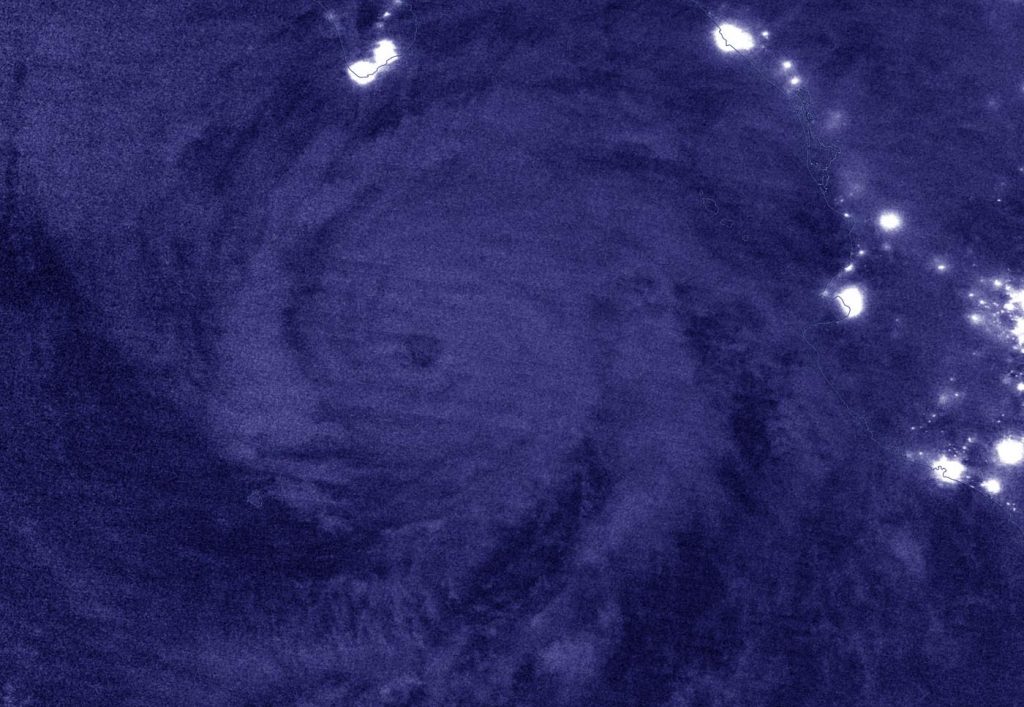
NASA-NOAA’s Suomi NPP satellite passed the Eastern Pacific Ocean overnight on Aug. 18 at 8 p.m. EDT (Aug. 19 at 0000 UTC) and captured a nighttime image of Hurricane Genevieve off the coast of western Mexico. City lights from the coastal communities can be seen in the image. Credit: NASA Worldview, Earth Observing System Data and Information System (EOSDIS)

NASA’s Night-Time View of Genevieve

The Visible Infrared Imaging Radiometer Suite (VIIRS) instrument aboard Suomi NPP provided a nighttime image of Hurricane Genevieve on Aug. 18 at 8 p.m. EDT (Aug. 19 at 0000 UTC).The hurricane’s eye was still visible and well defined. It was surrounded by powerful thunderstorms, although deep convection is generally lacking over the southwestern portion of the circulation.  The image was created using the NASA Worldview application.

Warnings and Watches on Aug. 19

NOAA’s National Hurricane Center issued a Hurricane Warning for the southern Baja California peninsula from Los Barriles to Todos Santos, Mexico. A Tropical Storm Warning is in effect for the west coast of the Baja California peninsula from north of Todos Santos to Cabo San Lazaro, and a Tropical Storm Watch is in effect for the east coast of the Baja California peninsula from Los Barriles to La Paz.

Hurricane Genevieve’s Status on Aug. 19

At 11 a.m. EDT (1500 UTC), the center of Hurricane Genevieve was located near latitude 20.9 degrees north and longitude 109.7 degrees west. That puts the eye about 140 miles (225 km) south of the southern tip of Baja California, Mexico. The estimated minimum central pressure is 959 millibars. Genevieve was moving toward the north-northwest near 9 mph (15 kph).

Maximum sustained winds are near 115 mph (185 km/h) with higher gusts.  Genevieve is a category 3 hurricane on the Saffir-Simpson Hurricane Wind Scale.

The NHC Forecast for Genevieve

NOAA’s NHC forecast noted, “Gradual weakening is forecast over the next couple of days, but Genevieve is expected to remain a strong hurricane while it passes west of the southern Baja California peninsula. A turn toward the northwest is expected this afternoon or tonight, with this motion continuing through Friday night.  On the forecast track, the center of Genevieve is expected to move near but just southwest of the southern portion of the Baja California peninsula tonight and Thursday, and move away from the peninsula on Friday.”

About NASA’s EOSDIS Worldview

NASA’s Earth Observing System Data and Information System (EOSDIS) Worldview application provides the capability to interactively browse over 700 global, full-resolution satellite imagery layers and then download the underlying data. Many of the available imagery layers are updated within three hours of observation, essentially showing the entire Earth as it looks “right now.”

NASA Researches Earth from Space

For more than five decades, NASA has used the vantage point of space to understand and explore our home planet, improve lives and safeguard our future. NASA brings together technology, science, and unique global Earth observations to provide societal benefits and strengthen our nation. Advancing knowledge of our home planet contributes directly to America’s leadership in space and scientific exploration.

For updated forecasts, visit: www.nhc.noaa.gov

By Rob Gutro 
NASA’s Goddard Space Flight Center

Genevieve – Eastern Pacific Ocean

Aug. 18, 2020 – NASA Satellite Data Helps Identify Genevieve as a Major Hurricane

 Very powerful storms with heavy rainmaking capability reach high into the atmosphere and those have very cold cloud top temperatures. Infrared imagery from NASA’s Terra satellite measured those temperatures and found powerful storms in the rapidly intensifying, major Hurricane Genevieve.

Aqua image of Genevieve
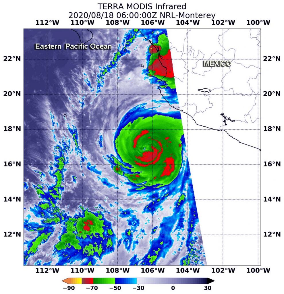
On Aug. 18 at 2 a.m. EDT (0600 UTC) the MODIS instrument that flies aboard NASA’s Terra satellite revealed the most powerful thunderstorms (yellow) were in Genevieve’s eyewall where cloud top temperatures were as cold as minus 80 degrees Fahrenheit (minus 62.2 Celsius). Slightly less cold cloud top temperatures in strong storms (red) were north and south of the center and in bands of thunderstorms. Credit: NASA/NRL

On Aug. 18, NOAA’s National Hurricane Center (NHC) noted that Genevieve had intensified into a Category 4 hurricane on the Saffir-Simpson Hurricane Scale. That makes Genevieve a major hurricane, and it is affecting the west coast of Mexico.

Warnings and Watches in Effect for Baja California

On Aug. 18, a Tropical Storm Warning is in effect for the southern Baja California peninsula from Los Barriles to Todos Santos. A Tropical Storm Watch is in effect for the east coast of the Baja California peninsula from Los Barriles to La Paz and for the west coast of the Baja California peninsula from Todos Santos to Santa Fe.

A Tropical Storm Warning means that tropical storm conditions are expected somewhere within the warning area within 36 hours. A Tropical Storm Watch means that tropical storm conditions are possible within the watch area, generally within 48 hours.

NASA’s Infrared Data Reveals Heavy Rainmakers

Tropical cyclones are made of up hundreds of thunderstorms, and infrared data can show where the strongest storms are located. That is because infrared data provides temperature information, and the strongest thunderstorms that reach highest into the atmosphere have the coldest cloud top temperatures.

On Aug. 18 at 2 a.m. EDT (0600 UTC), the Moderate Resolution Imaging Spectroradiometer or MODIS instrument that flies aboard NASA’s Aqua satellite used infrared light to analyze the strength of storms within Genevieve. MODIS found the most powerful thunderstorms were in the eyewall where cloud top temperatures were as cold as minus 80 degrees Fahrenheit (minus 62.2 Celsius). NASA research has found that cloud top temperatures that cold indicate strong storms with the potential to generate heavy rainfall.

Strong storms with cloud top temperatures as cold as minus 70 degrees Fahrenheit (minus 56.6. degrees Celsius) in the northern and southern quadrants and in bands around Genevieve were also dropping large amounts of rain.

At 5 a.m. EDT, National Hurricane Center forecaster Jack Beven utilized data from another NASA satellite, the Global Precipitation Measurement (GPM)’s Microwave Imager (GMI) instrument. Beven noted, “Genevieve continues to rapidly intensify this morning.  A recent GMI microwave overpass shows a well-defined eye and eyewall present, and the eye is becoming much better defined in conventional infrared imagery.”

Genevieve’s Status on July 26, 2020

At 8 a.m. EDT (1200 UTC), the eye of Hurricane Genevieve was located near latitude 17.7 degrees north and longitude 107.6 degrees west. Genevieve’s eye was about 235 miles (380 km) west-southwest of Manzanillo, Mexico.

Genevieve was moving toward the northwest near 16 mph (26 kph), and this general motion is expected to continue with a decrease in forward speed through early Thursday. The estimated minimum central pressure is 950 millibars. Maximum sustained winds have increased to near 130 mph (210 kph) with higher gusts.  Genevieve is a category 4 hurricane on the Saffir-Simpson Hurricane Wind Scale.  Additional rapid strengthening is possible during the next 12 to 24 hours.

Genevieve’s Forecast from NHC

On the forecast track, the center of Genevieve is expected to move parallel to but well offshore the coast of southwestern Mexico during the next day or so. The center of the hurricane is forecast to move to the southwest of the southern portion of the Baja California peninsula on Wednesday night (Aug. 19) and Thursday (Aug. 20). Rapid weakening is forecast to begin by late Wednesday and should continue through the end of the week.

NASA researches these storms to determine how they rapidly intensify, develop and behave.

Typhoons/hurricanes are the most powerful weather events on Earth. NASA’s expertise in space and scientific exploration contributes to essential services provided to the American people by other federal agencies, such as hurricane weather forecasting.

By Rob Gutro
NASA’s Goddard Space Flight Center

Genevieve – Eastern Pacific Ocean

Aug. 17, 2020 – NASA Infrared Data Shows Genevieve Strengthening into a Hurricane

NASA’s Terra satellite used infrared light to identify strongest storms and coldest cloud top temperatures and found them surrounding a developing eyewall around Genevieve as it was strengthening into a hurricane.

Aqua image of Genevieve
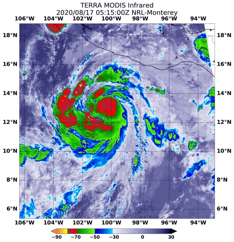
On Aug. 17 at 1:15 a.m. EDT (0515 UTC), the MODIS instrument aboard NASA’s Terra satellite gathered temperature information about Genevieve’s cloud tops. MODIS found the most powerful thunderstorms (red) were in the developing eyewall, where temperatures were as cold as or colder than minus 70 degrees Fahrenheit (minus 56.6 Celsius). Credit: NASA/NRL

Genevieve formed on Sunday by 11 a.m. EDT (1500 UTC) as Tropical Depression 12E. Six hours later, by 5 p.m. EDT, it had strengthened into a tropical storm and was renamed Tropical Storm Genevieve. The storm continued to intensify rapidly and by 11 a.m. EDT on Monday, Aug. 17, it strengthened to a hurricane.

Infrared Data Reveals Powerful Storms

On Aug. 17 at 1:15 a.m. EDT (0515 UTC), the Moderate Resolution Imaging Spectroradiometer or MODIS instrument aboard NASA’s Terra satellite gathered temperature information about Genevieve’s cloud tops. Infrared data provides temperature information, and the strongest thunderstorms that reach high into the atmosphere have the coldest cloud top temperatures.

MODIS found the most powerful thunderstorms were in the eyewall, where temperatures were as cold as or colder than minus 70 degrees Fahrenheit (minus 56.6 Celsius) around the center of circulation and in thick, fragmented bands south and west of the center. Cloud top temperatures that cold indicate strong storms with the potential to generate heavy rainfall.

Genevieve’s Status  

At 11 a.m. EDT (1500 UTC) on Aug. 17, NOAA’s National Hurricane Center reported the center of Hurricane Genevieve was located near latitude 14.3 degrees north and longitude 103.0 degrees west. The storm was about 250 miles (405 km) south-southwest of Zihuatanejo, Mexico.

Genevieve is moving toward the west-northwest near 18 mph (30 kph), and this motion is expected to continue through tonight. Maximum sustained winds are near 75 mph (120 kph) with higher gusts.

Forecast Track

NHC forecasters said, “A turn to the northwest and a decrease in forward speed is forecast to occur on Tuesday and continue through at least early Thursday. Rapid strengthening if forecast to continue over the next day or so, and Genevieve is expected to become a major hurricane on Tuesday. A weakening trend should begin on Wednesday. On the forecast track, the center of Genevieve is expected to move parallel to but well offshore the coast of southwestern Mexico during the next couple of days.”

Genevieve Causing Dangerous Ocean Swells Near Mexico

Large swells produced by Genevieve will begin affecting portions of the southern coast of Mexico today and will spread northward along the southwestern and west-central coast of Mexico to the Baja California peninsula through Wednesday.  These swells are likely to cause life-threatening surf and rip current conditions.

NASA Researches Tropical Cyclones

Tropical cyclones/hurricanes are the most powerful weather events on Earth. NASA’s expertise in space and scientific exploration contributes to essential services provided to the American people by other federal agencies, such as hurricane weather forecasting.

For updated forecasts, visit: www.nhc.noaa.gov

By Rob Gutro
NASA’s Goddard Space Flight Center