Aug. 28, 2020 – NASA Terra Satellite Sees Development of Tropical Storm Maysak
NASA infrared imagery revealed several areas of strong thunderstorms around the center of the recently organized Tropical Storm Maysak.
Tropical Depression 10W formed during the early morning hours on Aug. 28 and quickly organized and strengthened into a tropical storm.
Infrared Data Provides a Temperature Check
Infrared data provides temperature information, and the strongest thunderstorms that reach highest into the atmosphere have the coldest cloud top temperatures.
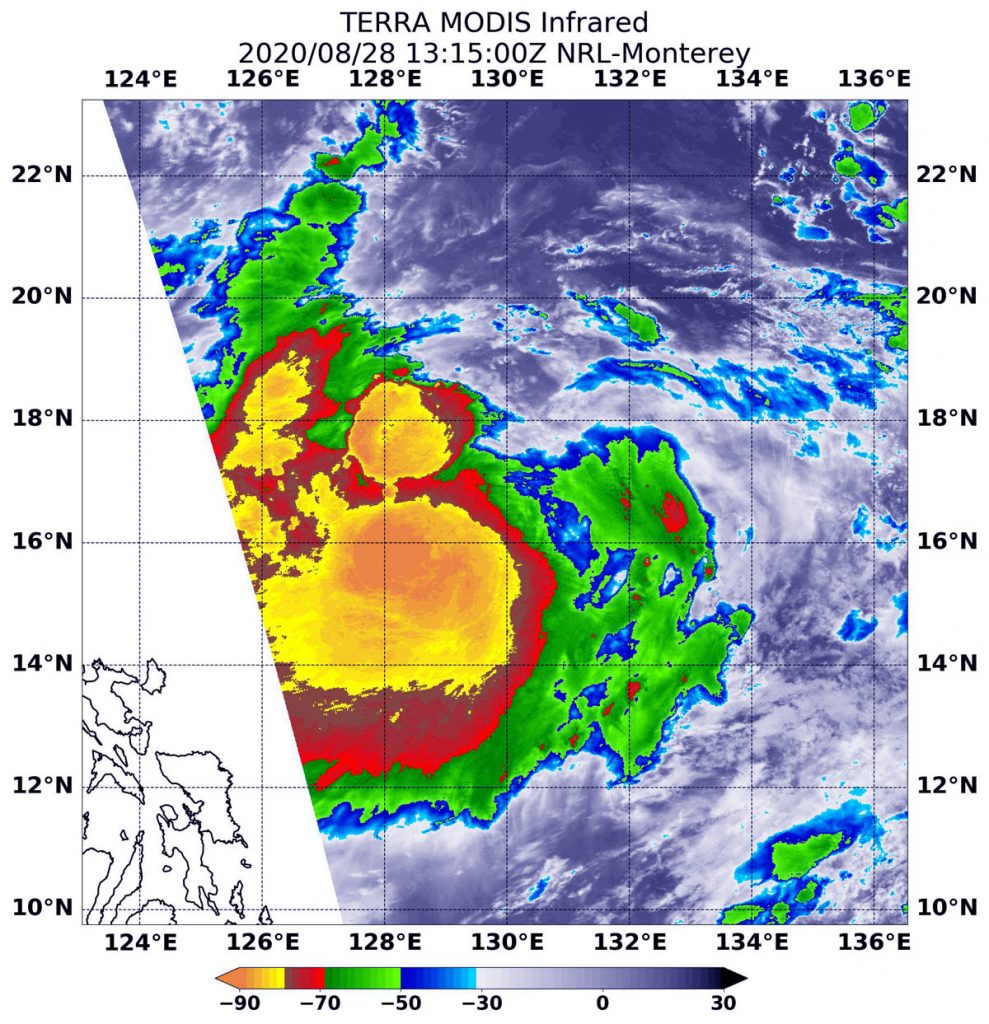
On Aug. 28 at 9:15 a.m. EDT (1315 UTC), the Moderate Resolution Imaging Spectroradiometer (MODIS) instrument aboard NASA’s Terra satellite captured an infrared image of cloud top temperatures in Maysak that showed a quick burst of strength. MODIS found the powerful thunderstorms that developed were as cold as or colder than minus 80 degrees Fahrenheit (minus 62.2 degrees Celsius) near Maysak’s center. Surrounding that area were cloud top temperatures were as cold as minus 70 degrees Fahrenheit (minus 56.6. degrees Celsius). All of those areas were generating heavy rain. The storm also appeared somewhat elongated from west to east.
Less than 2 hours later, infrared data showed those cloud tops were cooling, meaning they dropped in altitude. At 11 a.m. EDT (1500 UTC), the Joint Typhoon Warning Center noted, “Satellite imagery depicts an elongated low level circulation center partially obscured by deep convection [wind] sheared slightly to the southwest. Cloud tops have cooled significantly over the past 6 hours as the convection has continued to consolidate.”
Maysak’s Status on Aug. 28, 2020
At 11 a.m. EDT (1500 UTC), the center of Tropical Storm Maysak was located near latitude 16.3 degrees north and longitude 129.5 degrees east. That is about 619 miles south of Kadena Air Base, Okinawa Island, Japan. Maysak is moving to the west-southwest and has maximum sustained winds near 35 knots (40 mph).
Maysak is forecast to move northwest and pass just to the west of Okinawa Island on Aug. 31 as it tracks north.
NASA Researches Earth from Space
For more than five decades, NASA has used the vantage point of space to understand and explore our home planet, improve lives and safeguard our future. NASA brings together technology, science, and unique global Earth observations to provide societal benefits and strengthen our nation. Advancing knowledge of our home planet contributes directly to America’s leadership in space and scientific exploration.
For updated forecasts, visit: www.nhc.noaa.gov