Sep. 16, 2020 – NASA Finds Coldest Cloud Tops on Hurricane Teddy’s Western Side
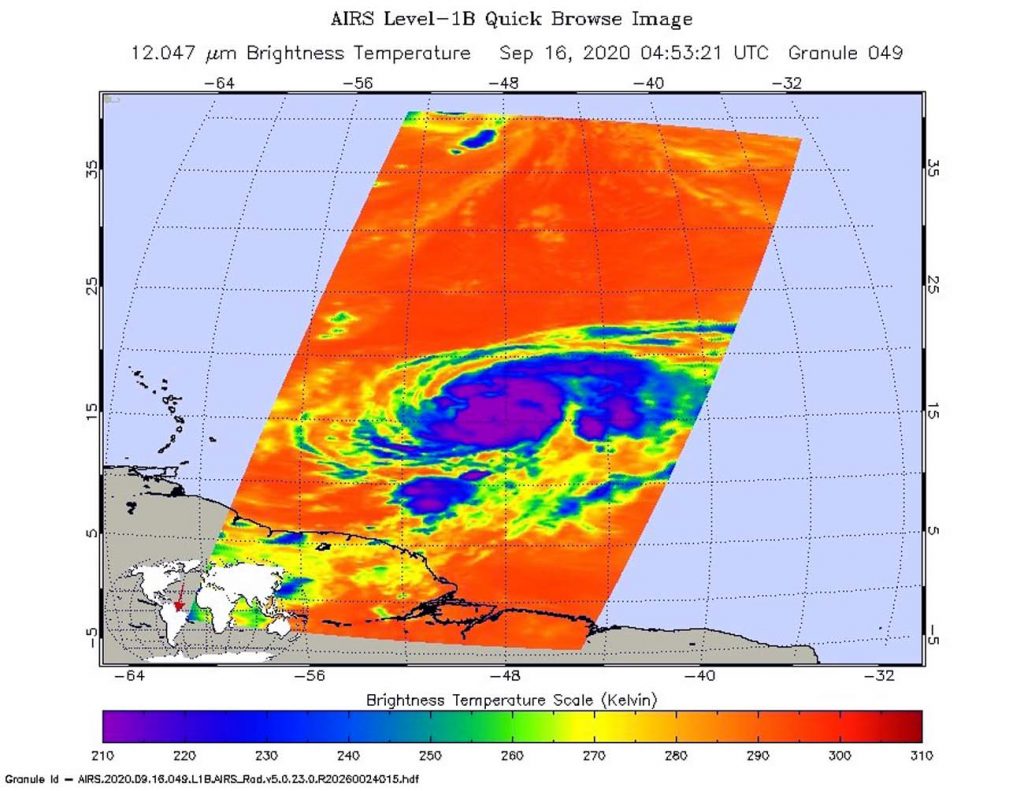
NASA analyzed the cloud top temperatures in Hurricane Teddy using infrared light to determine the strength of the storm. Infrared imagery revealed that the strongest storms were on Teddy’s western side.

An Infrared View of Teddy
One of the ways NASA researches tropical cyclones is using infrared data that provides temperature information. Cloud top temperatures identify where the strongest storms are located. The stronger the storms, the higher they extend into the troposphere, and the colder the cloud top temperatures.
On Sept. 16 at 12:53 a.m. EDT (0453 UTC) NASA’s Aqua satellite analyzed the storm using the Atmospheric Infrared Sounder or AIRS instrument. The AIRS imagery showed the strongest storms west of Teddy’s center of circulation. AIRS found coldest cloud top temperatures as cold as or colder 210 Kelvin minus 81 degrees Fahrenheit (minus 63.1 degrees Celsius). NASA research has shown that cloud top temperatures that cold indicate strong storms that have the capability to create heavy rain. The eye was barely visible in the infrared imagery.
NASA then provides data to tropical cyclone meteorologists so they can incorporate it in their forecasts.
Over 10 hours later at 11 a.m. EDT on Sept. 16, Andrew Latto, Hurricane Specialist at NOAA’s National Hurricane Center in Miami, Fla, noted, “Teddy’s overall appearance has changed little over the past several hours. Microwave and infrared satellite images depict a well-defined inner core with an eye evident in the microwave imagery. However, visible imagery reveals that the eye remains cloud filled. Over the past few hours, the coldest cloud tops and have become confined to the western portion of the circulation, which could be the early signs of the cyclone experiencing some westerly wind shear.”
Teddy’s Status on Sept. 16
At 11 a.m. EDT (1500 UTC), the center of Hurricane Teddy was located near latitude 16.5 degrees north and longitude 49.7 degrees west. Teddy was centered about 775 miles (1,245 km) east of the Lesser Antilles. Teddy was moving toward the northwest near 12 mph (19 kph) and this general motion is forecast to continue for the next few days. Maximum sustained winds are near 100 mph (155 kph) with higher gusts. The estimated minimum central pressure is 978 millibars.
Teddy’s Forecast
Additional strengthening is expected over the next couple of days, and Teddy could become a major hurricane by late tonight, Sept. 16.
In addition, large swells generated by Teddy are expected to reach the Lesser Antilles and the northeastern coast of South America today and should spread westward to the Greater Antilles, the Bahamas, and Bermuda by Friday, Sept. 18. These swells are likely to cause life-threatening surf and rip current conditions.
NASA Researches Earth from Space
For more than five decades, NASA has used the vantage point of space to understand and explore our home planet, improve lives and safeguard our future. NASA brings together technology, science, and unique global Earth observations to provide societal benefits and strengthen our nation. Advancing knowledge of our home planet contributes directly to America’s leadership in space and scientific exploration.
For updated forecasts, visit: www.hurricanes.gov
