Barry (was TD2) – Atlantic Ocean

July 13, 2019 – NASA Sees Heavy Rainfall Potential in Strengthening Tropical Storm Barry

Tropical Storm Barry continued to linger in the Gulf of Mexico, generating a lot of heavy rainfall on Saturday, July 13, 2019. Barry was just under the threshold of being classified a Category 1 hurricane and is expected to become one before landfall. NASA’s Aqua satellite analyzed cloud top temperatures in the storm which gave an indication of the storm’s strength.

Aqua image of Barry
At 3:15 a.m. EDT (0715 UTC) on July 13, the MODIS instrument aboard NASA’s Aqua satellite looked at Tropical Storm Barry in infrared light. MODIS found coldest cloud tops (light green) had temperatures near minus 80 degrees Fahrenheit (minus 62.2 degrees Celsius) around the center of the tropical storm which was offshore from south central Louisiana. Credit: NASA/NRL

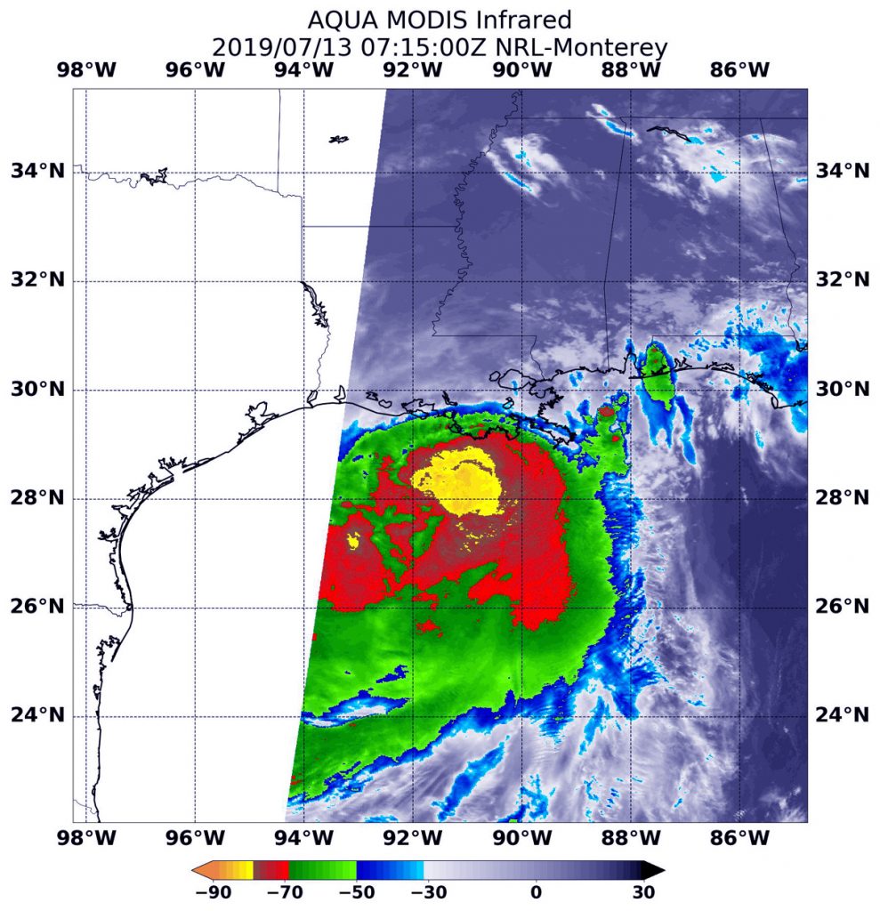
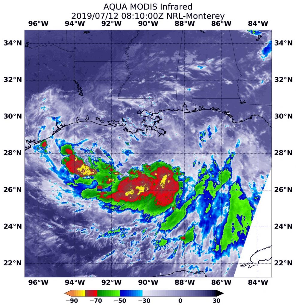
At 3:15 a.m. EDT (0715 UTC) on July 13, the MODIS or Moderate Resolution Imaging Spectroradiometer instrument aboard NASA’s Aqua satellite looked at Tropical Storm Barry infrared light. MODIS found coldest cloud tops had temperatures near minus 80 degrees Fahrenheit (minus 62.2 degrees Celsius) south and east around a slightly more rounded center of the tropical storm. Storms with temperatures that cold are indicative of strong storms and have been shown to have the capability to generate heavy rainfall.

The satellite image revealed a large area of strong thunderstorms that cold, surrounded by an even larger area of thunderstorms with cloud tops just slightly less cold. At the time of the image, the largest area of strong storms still appeared to be mostly south of the center of circulation and over the Gulf of Mexico. That’s because wind shear from the north-northwest is still battering the storm and pushing the strongest thunderstorms south and southeast of the center.

Barry’s Status on July 13, 2019

Barry is a strong tropical storm, just below the threshold of a hurricane and is forecast to reach hurricane status before landfalling. At 8 a.m. EDT (1200 UTC), the National Hurricane Center or NHC said the center of Tropical Storm Barry was located near latitude 29.3 North and longitude 91.9 West.  Barry is moving toward the northwest near 5 mph (7 km/h), and a turn toward the north is expected tonight or Sunday.

Maximum sustained winds have increased to near 70 mph (115 kph) with higher gusts.  Tropical-storm-force winds extend outward up to 175 miles (280 km) from the center.

Additional strengthening is forecast before landfall, and Barry is expected to be a hurricane when the center reaches the Louisiana coast during the next several hours.

Steady weakening is expected after Barry moves inland.

The estimated minimum central pressure based on surface observations is 991 millibars (29.26 inches).

 Warnings and Watches in Effect

The NHC posted many warnings and watches for Barry on July 13. A Hurricane Warning is in effect for Intracoastal City to Grand Isle, Louisiana. A Tropical Storm Warning is in effect from the mouth of the Pearl River to Grand Isle, Lake Pontchartrain and Lake Maurepas including metropolitan New Orleans, and from Intracoastal City to Cameron, La.

A Storm Surge Warning is in effect from Intracoastal City, La. to Biloxi, Mississippi and for Lake Pontchartrain. A Storm Surge Watch is in effect from Biloxi, Miss. to the Mississippi/Alabama border. A Hurricane Watch is in effect for the mouth of the Mississippi River to Grand Isle and from Intracoastal City to Cameron, La. A Tropical Storm Watch is in effect from east of the mouth of the Pearl River to the Mississippi / Alabama border.

Landfall in South-Central Louisiana Today

On the forecast track, the National Hurricane Center said the center of Barry will make landfall along the south-central Louisiana coast during the next several hours (after 8 a.m. EDT). After landfall, Barry is expected to move generally northward through the Mississippi Valley through Sunday night.

For updated forecasts, visit: www.nhc.noaa.gov

By Rob Gutro
NASA’s Goddard Space Flight Center

Barry (was TD2) – Atlantic Ocean

July 12, 2019 – Update #2 – NASA’s AIRS Images Tropical Storm Barry Before Landfall

NASA’s Atmospheric Infrared Sounder (AIRS), aboard the Aqua satellite, captured imagery of Tropical Storm Barry in the Gulf of Mexico at about 2 p.m. local time on Friday afternoon. According to the National Hurricane Center, Barry is expected to make landfall over the Louisiana coast on Saturday, likely as a hurricane.

Credits: NASA/JPL-Caltech
NASA’s AIRS instrument imaged Tropical Storm Barry on the afternoon of July 12, 2019, a day before the storm is expected to make landfall on the Louisiana Coast.

In the infrared AIRS image, the large purple area indicates very cold clouds that have been carried high into the atmosphere by deep thunderstorms. These clouds are associated with heavy rainfall. Warmer areas with shallower rain clouds are shown in blue and green. And the orange and red areas represent mostly cloud-free air.

At the time the image was captured, Barry had maximum sustained winds of 65 mph (105 kph). When the storm reaches maximum sustained winds of 74 mph (119 kph), it will be upgraded to hurricane status. The National Hurricane Center notes that the slow movement of the storm will result in long periods of heavy rain, dangerous storm surge and flooding in parts of the central Gulf Coast into the Lower Mississippi Valley.

AIRS, in conjunction with the Advanced Microwave Sounding Unit (AMSU), senses emitted infrared and microwave radiation from Earth to provide a three-dimensional look at Earth’s weather and climate. Working in tandem, the two instruments make simultaneous observations down to Earth’s surface. With more than 2,000 channels sensing different regions of the atmosphere, the system creates a global, three-dimensional map of atmospheric temperature and humidity, cloud amounts and heights, greenhouse gas concentrations and many other atmospheric phenomena. Launched into Earth orbit in 2002, the AIRS and AMSU instruments fly onboard NASA’s Aqua spacecraft and are managed by NASA’s Jet Propulsion Laboratory in Pasadena, California, under contract to NASA. JPL is a division of Caltech.

More information about AIRS can be found at: https://airs.jpl.nasa.gov

By Esprit Smith
Jet Propulsion Laboratory, Pasadena, Calif.
818-354-4269
esprit.smith@jpl.nasa.gov

Barry (was TD2) – Atlantic Ocean

July 12, 2019 – Update #1 – NASA Finds an Asymmetric Tropical Storm Barry

Infrared imagery from NASA’s Aqua satellite shows that Tropical Storm Barry doesn’t look like a typical strong tropical cyclone. Imagery revealed that Barry is elongated and the strongest storms were south of it’s stretched out center of circulation.   

Aqua image of Barry
On July 12 at 4:10 a.m. EDT (0810 UTC) the MODIS instrument that flies aboard NASA’s Aqua satellite showed strongest storms in Tropical Storm Barry were south of the elongated center where cloud top temperatures were as cold as minus 70 degrees Fahrenheit (minus 56.6 Celsius). Credit: NASA/NRL

Warnings and Watches

At 8 a.m. EDT (1200 UTC) on Friday, July 12, NOAA’s National Hurricane Center (NHC) in Miami, Florida said that Barry is moving slowly to the west-northwest in the Gulf of Mexico, and south of the coast of southeastern Louisiana. NHC warns of dangerous storm surge, heavy rains, and wind conditions expected across the north-central Gulf coast.

Many warnings and watches are in effect as Barry hugs that northern Gulf coast, hammering the region. A Hurricane Warning is in effect from Intracoastal City to Grand Isle, Louisiana. A Tropical Storm Warning is in effect from the mouth of the Pearl River to Grand Isle, La. and for Lake Pontchartrain and Lake Maurepas including metropolitan New Orleans, and from Intracoastal City, Louisiana to Cameron, Louisiana.

A Storm Surge Warning is in effect from Intracoastal City to Shell Beach, Louisiana. A Storm Surge Watch is in effect from Shell Beach to the Mississippi/Alabama border and for Lake Pontchartrain. A Hurricane Watch is in effect from the mouth of the Mississippi River to Grand Isle, La. and for Intracoastal City to Cameron, La. A Tropical Storm Watch is in effect from east of the Mouth of the Pearl River to the Mississippi/Alabama border.

Satellite Imagery

NASA’s Aqua satellite used infrared light to analyze the strength of storms and found the bulk of them in the southern quadrant. Infrared data provides temperature information, and the strongest thunderstorms that reach high into the atmosphere have the coldest cloud top temperatures.

On July 12 at 4:10 a.m. EDT (0810 UTC),  the Moderate Imaging Spectroradiometer or MODIS instrument that flies aboard NASA’s Aqua satellite gathered infrared data on Tropical Storm Barry. Strongest thunderstorms had cloud top temperatures as cold as minus 70 degrees Fahrenheit (minus 56.6 Celsius). Cloud top temperatures that cold indicate strong storms with the potential to generate heavy rainfall. Those strongest storms were south and southeast of the center of the elongated circulation.

The NHC said, “Barry does not have the typical presentation of a tropical cyclone on satellite imagery at this time. The cloud pattern consists of a cyclonically curved convective band on the southern semicircle, and the system is devoid of an inner convective core near the center. Barry is an asymmetric storm with most of the tropical-storm-force winds occurring in the eastern semicircle. Tropical-storm-force winds extend outward up to 175 miles (280 km) to the east of the center.”

Barry’s Status on July 12, 2019 at 8 a.m. EDT

On July 12 at 8 a.m. EDT (1200 UTC), the National Hurricane Center (NHC) said the broad circulation center of Tropical Storm Barry was located near latitude 28.2 degrees north and longitude 90.3 degrees west. The minimum central pressure based on the Hurricane Hunter aircraft data is 998 millibars (29.47 inches).

Barry is moving toward the west-northwest near 5 mph (7 kph). A track toward the northwest is expected to begin later in the day on Friday, July 12, followed by a turn toward the north on Saturday, July 13.

Reports from NOAA and Air Force Reserve Hurricane Hunter aircraft indicate that the maximum sustained winds remain near 50 mph (85 kph) with higher gusts. Some strengthening is expected during the next day or so, and Barry could become a hurricane tonight or early on July 13 when the center is near the Louisiana coast. After landfall, weakening is expected after Barry moves inland.

Barry’s Path Forward

On the NHC forecast track, the center of Barry will be near or over the central or southeastern coast of Louisiana tonight or Saturday, July 13 and then move inland over the Lower Mississippi Valley on Sunday, July 14.

Key Messages from the National Hurricane Center

  1. There is a danger of life-threatening storm surge inundation along the coast of southern and southeastern Louisiana where a Storm Surge Warning is in effect. The highest storm surge inundation is expected between Intracoastal City and Shell Beach. Residents in these areas should listen to any advice given by local officials.
  2. The slow movement of Barry will result in a long duration heavy rainfall and flood threat along the central Gulf Coast and inland through the lower Mississippi Valley through the weekend into early next week. Flash flooding and river flooding will become increasingly likely, some of which may be significant, especially along and east of the track of the system.
  3. Hurricane conditions are expected along a portion of the coast of Louisiana, where a Hurricane Warning has been issued. Residents in these areas should rush their preparations to completion, as tropical storm conditions are expected to arrive in the warning area by Friday morning.

For updated forecasts, visit: https://www.nhc.noaa.gov

By Rob Gutro
NASA’s Goddard Space Flight Center

Barry (was TD2) – Atlantic Ocean

July 11, 2019 – Update #4 – GPM Satellite Provides a 3D Look at Tropical Storm Barry

The Global Precipitation Measurement mission or GPM core satellite provided a couple of views of Tropical Storm Barry that showed its cloud heights and rainfall rates.

GPM image of Barry
On July 11, 2019 at 8:26 a.m. CDT, GPM captured estimates of rainfall rates within the storm and found they exceeded 100 mm/hr (4 inches/hr) in the strongest storms within Barry. Image Credit: Jacob Reed / NASA

Tropical Storm Barry formed during the morning of July 11 and the National Hurricane Center has issued several warnings and watches. A Tropical Storm Warning is in effect from the mouth of the Pearl River to Morgan City. A Storm Surge Warning is in effect from the mouth of the Atchafalaya River to Shell Beach. A Storm Surge Watch is in effect for Shell Beach to the Mississippi/Alabama border and for the mouth of the Atchafalaya River to Intracoastal City.

There is also a hurricane and tropical storm watch in effect. A Hurricane Watch is in effect from the mouth of the Mississippi River to Cameron and a Tropical Storm Watch is in effect from east of the Mouth of the Pearl River to the Mississippi/Alabama border and for Lake Pontchartrain and Lake Maurepas including metropolitan New Orleans.

NASA and the Japan Aerospace Exploration Agency’s (JAXA) GPM Core Observatory passed over developing Tropical Depression 2 (which was upgraded to Tropical Storm Barry later in the morning) in the Gulf of Mexico the morning of July 11, 2019 at 8:26 a.m. CDT, capturing estimates of rainfall rates within the storm using GPM’s Microwave Imager (GMI) instrument.

GPM 3-D image of Barry
The GPM core satellite measured storm top heights as high as 18 kilometers (11.1 miles), which is extremely high and indicative of intense thunderstorm activity south of central Louisiana. It also shows 3-D rainfall rates within the atmospheric storm column. Rainfall rates within these storms exceeded 100 mm/hr (4 inches/hr) as well. Image Credit: Jacob Reed / NASA

GPM’s Dual-frequency Precipitation Radar (DPR) measured storm top heights as high as 18 kilometers (11.1 miles), which is extremely high and indicative of intense thunderstorm activity south of central Louisiana. Rainfall rates with these storms exceeded 100 mm/hour (4 inches/hr) as well. Despite these intense storms, activity was not yet organized near the storm center and so flooding due to rainfall, rather than strong winds and storm surge, are the primary threat with Barry at this time.

At 2 p.m. EDT (1800 UTC), the center of Tropical Storm Barry was located near latitude 27.8 North, longitude 89.0 West. Barry is moving toward the west near 5 mph (7 km/h) and this motion is expected to continue today.  Reports from an Air Force Reserve Hurricane Hunter aircraft indicate that maximum sustained winds are near 40 mph (65 kph) with higher gusts.

Tropical-storm-force winds extend outward up to 90 miles (150 km) mainly to the southeast of the center. The minimum central pressure based on aircraft and surface observations is 1006 millibars (29.71 inches).

The National Hurricane Center noted that “Strengthening is expected during the next day or two, and Barry could become a hurricane late Friday or early Saturday [July 13].

A turn toward the west-northwest is expected tonight, followed by a turn toward the northwest on Friday. On the forecast track the center of Barry will be near the central or southeastern coast of Louisiana Friday night or Saturday.”

For updated forecasts, visit: www.nhc.noaa.gov

By Joe Munchak / Rob Gutro
NASA’s Goddard Space Flight Center

Barry (was TD2) – Atlantic Ocean

July 11, 2019 – Update #3 –  International Space Station Eyes Tropical Storm Barry

U.S. Astronaut Christina Koch, currently stationed on the International Space Station, captured this image of Tropical Storm Barry as it bears down on Texas, Louisiana, Alabama, and the panhandle of Florida and it makes its way through the Gulf of Mexico.

ISS image of Barry
ISS Astronaut Christina Koch captured this image of Barry on July 11 from the space station. Credit: NASA

Credit: NASA/Christina Koch

Barry (was TD2 – Atlantic Ocean)

July 11, 2019 – Update #2 – NASA’s Aqua Satellite Sees Formation of Tropical Storm Barry

The National Hurricane Center (NHC) confirmed that Tropical Storm Barry formed in the Gulf of Mexico today, July 11 at 11 a.m. EDT (1500 UTC). NASA’s Aqua satellite provided a view of the storm’s clouds and temperatures as Barry continued consolidating.

AIRS image of Barry
On July 11, 2019 at 3:29 p.m. EDT (0729 UTC) the AIRS instrument aboard NASA’s Aqua satellite analyzed cloud top temperatures in infrared light in what was at the time, Potential Tropical Cyclone 2. Credit: NASA JPL/Heidar Thrastarson

On July 11, 2019 at 3:29 p.m. EDT (0729 UTC) the AIRS instrument aboard NASA’s Aqua satellite analyzed cloud top temperatures in infrared light in what was at the time, Potential Tropical Cyclone 2. AIRS found coldest cloud top temperatures (purple) of strongest thunderstorms were as cold as or colder than minus 63 degrees Fahrenheit (minus 53 degrees Celsius). Cloud tops that cold can produce heavy rainfall and the NHC said dangerous storm surge, heavy rains, and wind conditions are expected across the north-central Gulf Coast from Barry.

The image also showed the storm had become better defined and bands of thunderstorms were wrapping around the low-level center.

For updates from the National Hurricane Center visit: www.nhc.noaa.gov

Credit: NASA JPL/Heidar Thrastarson

TD2 – (Atlantic Ocean)

July 11, 2019 – Update #1 – NASA Takes Potential Tropical Cyclone 2’s Temperature

NASA’s Aqua satellite passed over the Gulf of Mexico and took the temperature of Potential Tropical Cyclone 2 as it moved westward through the Gulf of Mexico. NASA found the very cold cloud tops indicating the storm had potential for dropping heavy rain.

AIRS image of Barry
On July 10, 2019 at 3:23 p.m. EDT (1923 UTC) the AIRS instrument aboard NASA’s Aqua satellite analyzed cloud top temperatures of Potential Tropical Cyclone 2 in infrared light. AIRS found coldest cloud top temperatures (purple) of strongest thunderstorms were as cold as or colder than minus 63 degrees Fahrenheit (minus 53 degrees Celsius). Credit: NASA JPL/Heidar Thrastarson

Infrared light enables NASA to take the temperatures of clouds and thunderstorms that make up tropical cyclones. The stronger the storms are indicate that they extend high into the troposphere and have cold cloud top temperatures.

An infrared look by NASA’s Aqua satellite on July 10, 2019 at 3:23 p.m. EDT (1923 UTC) revealed where the strongest storms were located within Potential Tropical Cyclone 2. The Atmospheric Infrared Sounder or AIRS instrument aboard NASA’s Aqua satellite analyzed cloud top temperatures and found cloud top temperatures of strongest thunderstorms as cold as or colder than minus 63 degrees Fahrenheit (minus 53 degrees Celsius) circling the center  (which is still not well-defined) and in thunderstorms northwest of the center, extending over southern Louisiana. Cloud top temperatures that cold indicate strong storms that have the capability to create heavy rain.

On July 10, the National Weather Service Office in New Orleans reported the official rainfall in New Orleans at more than 7 inches, which fell over six hours on the morning of July 10.

On July 11 at 8 a.m. EDT (1200 UTC) NOAA’s National Hurricane Center (NHC) continued to post warnings and watches for the Gulf coast states. A Storm Surge Watch is in effect from the mouth of the Pearl River to Intracoastal City, Louisiana. A Hurricane Watch is in effect from the mouth of the Mississippi River to Cameron, and a Tropical Storm Watch is in effect from the mouth of the Mississippi River northward to the mouth of the Pearl River.

At 8 a.m. EDT (1200 UTC), the NHC said the disturbance was centered near latitude

27.6 degrees north and longitude 88.5 degrees west. That puts the center of circulation about 115 miles (185 km) south-southeast of the mouth of the Mississippi River. Reports from a NOAA Hurricane Hunter aircraft indicate that maximum sustained winds are near 35 mph (55 km/h) with higher gusts. Strengthening is forecast during the next couple of days, and the disturbance is forecast to become a tropical depression or a tropical storm later today, and could become a hurricane by late Friday.

NHC noted that the associated thunderstorm activity is gradually becoming better organized, and the disturbance is expected to become a tropical depression or a tropical storm later today or Friday. The chance that the system will become a tropical storm through 48 hours is high at 100 percent.

The system is moving toward the west near 5 mph (7 kph), but the NHC forecasters said a west-northwest motion is expected on Friday, July 12, followed by a northwestward track by early Saturday.  On the forecast track, the system is expected to approach the Louisiana coast this weekend.

For updated forecasts, visit: www.nhc.noaa.gov

By Rob Gutro
NASA’s Goddard Space Flight Center

TD2 (Atlantic Ocean)

July 10, 2019 – Satellites Analyzing Developing Gulf Potential Tropical Cyclone Two

A massive complex of thunderstorms over the southeastern United States slid into the northeastern Gulf of Mexico and now has the potential to develop into a tropical cyclone. NOAA’s National Hurricane Center or NHC in Miami, Florida issued the first advisory of Potential Tropical Cyclone Two and NOAA’s GOES-East satellite and NASA’s GPM satellite provided views of the storm.

GOES image of TD2
On July 10, 2019 at 11 a.m. EDT (1500 UTC) NOAA’s GOES-East satellite provided a visible image of Potential Tropical Cyclone Two as it continued to develop in the northeastern Gulf of Mexico. Credit: NOAA/NRL

On July 10 at 11 a.m. EDT (1500 UTC), NOAA’s GOES-East satellite provided a visible image of the developing storm. The NHC said, “High-resolution satellite imagery along with surface and upper-air data indicate that the broad low pressure system located over the northeastern Gulf of Mexico has become a little better defined.”

The Global Precipitation Measurement mission or GPM core satellite passed over the developing area of low pressure early on July 10 and found rain was falling at a rate of more than 50 mm (about 2 inches) per hour. Forecasters at the NHC said that the system has the potential to produce very heavy rainfall along and inland of the central Gulf Coast through early next week. GPM is a joint mission between NASA and the Japan Aerospace Exploration Agency, JAXA.

NHC noted, “A tropical cyclone is expected to form by Thursday [July 11] over the north-central Gulf of Mexico. At 2 p.m. EDT on July 10, NHC reported that heavy rains and flooding were already occurring over portions of southeastern Louisiana.

Because this developing area of low pressure has the potential to bring tropical storm conditions and storm surge to portions of the coast of Louisiana by late Thursday or Friday, the NHC initiated Potential Tropical Cyclone advisories. A Storm Surge Watch is in effect from the mouth of the Pearl River to Morgan City, Louisiana and a Tropical Storm Watch is in effect from the mouth of the Mississippi River to Morgan City.

At 2 p.m. EDT (1800 UTC), the disturbance was centered near latitude 28.3 degrees north and longitude 86.7 degrees west. That’s about 155 miles (250 km) east-southeast of the mouth of the Mississippi River. The system is moving toward the west-southwest near 8 mph (13 kph). On the forecast track, the system is expected to approach the central U.S. Gulf Coast this weekend.

Maximum sustained winds are near 30 mph (45 kph) with higher gusts. Strengthening is forecast during the next 72 hours, and the disturbance is forecast to become a tropical depression Thursday morning, a tropical storm Thursday night, and a hurricane on Friday, July 12. The estimated minimum central pressure is 1011 millibars. The chance the system will develop into a tropical depression in the next 48 hours is near 100 percent.

Residents along the Gulf need to heed the warnings issued by the National Hurricane Center and National Weather Service local offices. Already, Flash Flood Watches and Warnings were in effect today in southern Louisiana including New Orleans.

Dangerous storm surge is possible in portions of southeast Louisiana and the risk for dangerous storm surge impacts also exists farther west along the Louisiana coast into the Upper Texas coast. The National Weather Service Office in New Orleans issued a local statement today that also urged residents to prepare for dangerous rainfall flooding having possible significant impacts across extreme southeast Louisiana and coastal Mississippi.

For forecast updates on the system, visit: www.nhc.noaa.gov.

By Rob Gutro
NASA’s Goddard Space Flight Center

Cosme (Eastern Pacific Ocean)

July 08, 2019 – NASA Catches Post Tropical Cyclone Cosme Fading

Tropical Storm Cosme formed in the Eastern Pacific Ocean over the weekend of July 6 and 7 and after two days, the storm already weakened to a remnant low pressure area. NASA’s Aqua satellite found the storm devoid of strong thunderstorms and appeared as a wispy ring of clouds.

Aqua image of Cosme
On July 8 at 6:15 a.m. EDT (1015 UTC), NASA’s Aqua satellite passed over the Cosme from space. The storm appeared to have a circulation of wispy high clouds. Credit: NASA/NRL

At 11 a.m. EDT (1500 UTC) on Saturday, July 6, Tropical Storm Cosme formed near latitude 15.6 degrees north and longitude 115.7 degrees west. That is about 630 miles (1,015 km) southwest of the southern tip of Baja California, Mexico.

On July 8 at 6:15 a.m. EDT (1015 UTC), NASA’s Aqua satellite passed over the Cosme from space. The storm appeared to have a circulation of wispy high clouds.  Five hours later, the low pressure area was devoid of precipitation and the National Hurricane Center noted, “Cosme has degenerated into a large swirl of mostly cold-air stratocumulus clouds.”

At 11 a.m. EDT (1500 UTC), the center of Post-Tropical Cyclone Cosme was located near latitude 20.5 North, longitude 120.7 West.  Cosme reached its peak later on the day it formed when maximum sustained winds topped out at 50 mph (85 kph) around 5 p.m. EDT. Since then, Cosme was on a weakening trend.

The update on July 8 at 11 a.m. EDT (1500 UTC) was the last public advisory issued by the National Hurricane Center on Cosme.  Cosme degenerated into a post-tropical remnant low pressure area. At that time, Cosme was located about 710 miles (1,140 km) west of the southern tip of Baja California, Mexico. The National Hurricane Center noted that the post-tropical cyclone is moving toward the northwest near 8 mph (13 kph) and this general motion is expected to continue for the next couple of days with a decrease in forward speed. Maximum sustained winds are near 30 mph (45 kph) with higher gusts.

Weakening is expected during the next 48 hours, and the remnant low pressure area is forecast to dissipate by Wednesday, July 10.

By Rob Gutro
NASA’s Goddard Space Flight Center

Barbara (Eastern Pacific Ocean)

July 5, 2019, Update – NASA-NOAA Satellite Catches Hurricane Barbara’s Closing Eye

Hurricane Barbara continued to track west through the Eastern Pacific Ocean when NASA-NOAA’s Suomi NPP satellite passed overhead on July 4. Satellite imagery revealed clouds filling into Barbara’s eye as wind shear continued to weaken the storm and push the bulk of its clouds north of the center.

Hurricane Barbara continued to show an eye in visible imagery on July 4, 2019. NASA-NOAA’s Suomi NPP satellite passed over the Eastern Pacific Ocean and the VIIRS instrument aboard captured this image of the storm. Credit: NASA Worldview, Earth Observing System Data and Information System (EOSDIS)

The Visible Infrared Imaging Radiometer Suite (VIIRS) instrument aboard Suomi NPP provided a visible image of the storm. The VIIRS image and microwave satellite imagery indicates that Barbara is being torn apart by winds outside or around the storm. In general, wind shear is a measure of how the speed and direction of winds change with altitude. The National Hurricane Center noted that the eyewall structure appears to be disintegrating and the low-level center is located to the south of the remaining strong thunderstorms.

There are several factors weakening the once Category 4 hurricane: increasing southwesterly wind shear, dry air moving into the storm and sapping the moisture and energy, and cooler sea surface temperatures that lay ahead of the storm as it continues moving west.

At 5 a.m. EDT (0900 UTC) on July 5, NOAA’s National Hurricane Center said the eye of Hurricane Barbara was located near latitude 17.7 degrees north and longitude 132.6 degrees west. That puts the eye about 1,475 miles (2,375 km) east of Hilo, Hawaii. Barbara is moving toward the northwest near 12 mph (19 kph). The forecast calls for a gradual turn toward the west through Saturday, July 6. The estimated minimum central pressure is 980 millibars (28.94 inches).

Maximum sustained winds have decreased to near 80 mph (130 kph) with higher gusts. Hurricane-force winds extend outward up to 35 miles (55 km) from the center and tropical-storm-force winds extend outward up to 150 miles (240 km).

Barbara is on a weakening trend. 24 hours earlier the storm had maximum sustained winds near 120 mph (195 kph). Forecasters expect additional rapid weakening and Barbara is expected to become a post-tropical cyclone late on July 6.

For updated forecasts on Barbara, visit: www.nhc.noaa.gov

Rob Gutro
NASA’s Goddard Space Flight Center, Greenbelt, Md.