Oct. 26, 2018 – NASA’s Aqua Satellite Tracks Super Typhoon Yutu’s Oblong Eye
Visible satellite imagery from NASA’s Aqua satellite captured powerful Super Typhoon Yutu as it moved through the Philippine Sea. Yutu’s eye appeared oblong on satellite imagery.
On Oct. 25 at 1:30 p.m. CHST (local time, Guam) the MODIS instrument aboard Aqua captured a visible image of Typhoon Yutu with a 19 nautical mile oblong eye. Credit: NASA Worldview, Earth Observing System Data and Information System (EOSDIS) Credit: NASA Worldview, Earth Observing System Data and Information System (EOSDIS)
On Oct. 25 at 1:30 p.m. CHST (local time, Guam) the Moderate Resolution Imaging Spectroradiometer or MODIS instrument aboard Aqua captured a visible image of Yutu. The MODIS image showed that large typhoon Yutu continued to remain symmetric with an open 19 nautical-mile-wide eye surrounded by very thick bands of powerful thunderstorms circling the center. At the time of the image, Yutu had passed and cleared Guam.
In satellite imagery on Oct. 26, the eye had become cloud-filled. Infrared satellite imagery revealed cooler cloud tops (indicating the uplift of air had strengthened) and a contracting eye occurring after the storm experienced an eyewall replacement cycle.
Mature, intense tropical cyclones can and often undergo an eyewall replacement cycle. That’s where a new eyewall or ring of thunderstorms within the outer rain bands forms further out from the storm’s center, outside of the original eye wall. That ring of thunderstorms then begins to choke off the original eye wall, starving it of moisture and momentum. Eventually, if the cycle is completed, the original eye wall of thunderstorms dissipates and the new outer eye wall of thunderstorms contracts and replace the old eye wall. The storm’s intensity can fluctuate over this period, initially weakening as the inner eye wall dies before again strengthening as the outer eye wall contracts.
The National Weather Service (NWS) in Tiyan, Guam continued to issue a small craft advisory on Oct. 26. The NWS noted for Marianas Waters “Winds and seas will remain elevated, then slowly subside over the weekend as Super Typhoon Yutu moves away from the Marianas. A Small Craft Advisory remains in effect through Saturday afternoon.”
At 11 a.m. EDT (1500 UTC) on Oct. 26, the Joint Typhoon Warning Center or JTWC noted that Yutu had maximum sustained winds near 135 knots (155.4 mph/250 kph).
Super Typhoon Yutu was the equivalent of a Category 4 hurricane on the Saffir-Simpson Hurricane Wind Scale. Yutu was centered near 17.3 degrees north latitude and 136.9 east longitude. It was about 465 nautical miles west-northwest of Navsta, Guam. Yutu was moving toward the west-northwest.
The JTWC forecast carries Yutu west toward the northern Philippines through Oct. 31. Yutu is expected to maintain typhoon strength through that time.
NASA’s GPM Core observatory satellite captured an image of Super Typhoon Yutu when it flew over the powerful storm just as the center was striking the central Northern Mariana Islands north of Guam.
Early Thursday, Oct. 25 local time, Super Typhoon Yutu crossed over the U.S. commonwealth of the Northern Mariana Islands. It was the equivalent of a Category 5 hurricane. The National Weather Service in Guam said it was the strongest storm to hit any part of the U.S. this year.
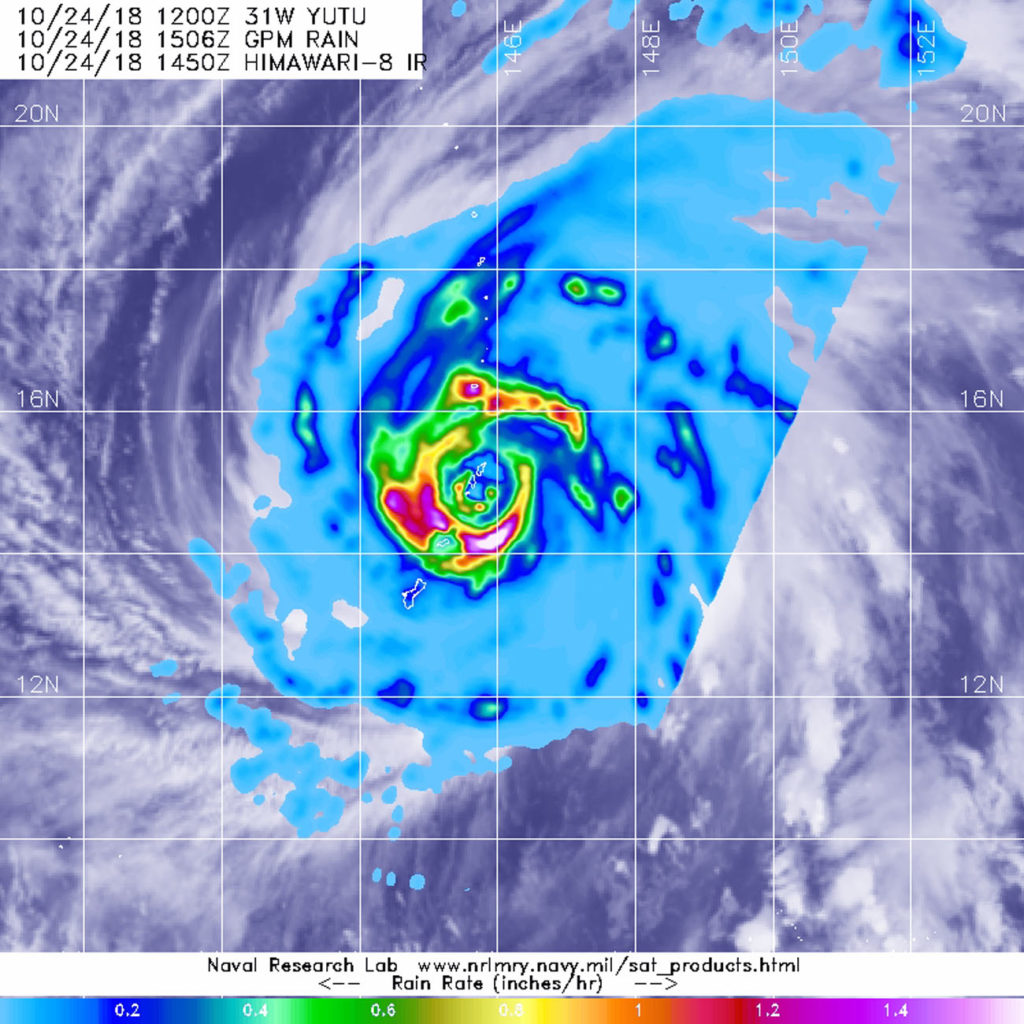
On Oct. 24 at 11:07 a.m. EDT (1507 UTC)/ 1:07 a.m. Guam Time, Oct. 25, GPM shows the inner eyewall as a near perfect ring of heavy to intense rain (shown by the circle of darker red and magenta). Peak rain rates of up to 269 mm/hr. (~10.6 inches/hr.) were estimated within the DPR swath. The almost perfect symmetry of the inner wall is indicative of an extremely powerful storm. The eyewall replacement is evidenced by the emerging ring of heavy rain outside of the inner eyewall separated by the area of weaker rain (shown in blue). Credit: NASA/JAXA, Hal Pierce
The Global Precipitation Measurement mission or GPM core satellite, which is managed by both NASA and the Japan Aerospace Exploration Agency, JAXA analyzed Yutu on Oct. 24 at 11:07 a.m. EDT (1507 UTC)/ 1:07 a.m. Guam Time, Oct. 25. GPM estimated rain rates within Super Typhoon Yutu fusing data from two instruments aboard: the GPM Dual-frequency Precipitation Radar or DPR, which covered the inner part of the storm, and the GPM Microwave Imager or GMI that analyzed the outer swath, just as the center was passing over the Island of Tinian.
GPM shows the inner eyewall as a near perfect ring of heavy to intense rain. Peak rain rates of up to 269 mm/hr. (~10.6 inches/hr.) were estimated within the DPR swath. The almost perfect symmetry of the inner wall is indicative of an extremely powerful storm. In fact, at the time this image was taken, Yutu’s maximum sustained winds were estimated at 155 knots (~178 mph) by the Joint Typhoon Warning Center, making it the strongest typhoon on record to strike Saipan and Tinian.
In this 3D image from GPM data on Super Typhoon Yutu on Oct. 24 at 11:017 a.m. EDT (1507 UTC)/ 1:07 a.m. Guam Time, Oct. 25, the double eyewall structure is readily apparent by the two rings of taller towers evident in the precipitation top heights. The tallest tower is located in the southeast part of the outer eyewall and is 15.7 km (9.7 miles) high. Credit: NASA/JAXA, Hal Pierce
For comparison, Hurricane Michael, which devastated the northern Gulf Coast of Florida, had maximum sustained winds reported at 155 mph. At the time of the satellite flyover, GPM showed the northern eyewall passing right over Tinian and the southern tip of Saipan. GPM also reveals another interesting feature common with powerful tropical cyclones, the beginning of an eyewall replacement cycle.
After strong hurricanes and typhoons reach maturity, they often undergo an eyewall replacement cycle wherein a concentric outer eyewall forms outside and around the inner eyewall before contracting and eventually replacing the inner eyewall. This is evidenced by the emerging ring of heavy rain outside of the inner eyewall separated by the area of weaker rain.
At NASA’s Goddard Space Flight Center in Greenbelt, Maryland, a second image was created at the same time as the first and shows a unique 3D perspective of Yutu courtesy of the GPM DPR. In that image the double eyewall structure is readily apparent by the two rings of taller towers evident in the precipitation top heights. The tallest tower is located in the southeast part of the outer eyewall and is 15.7 km (9.7 miles) high.
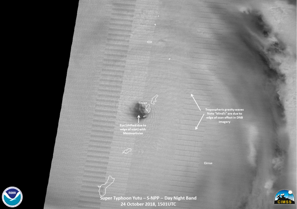
Super Typhoon Yutu has made a direct hit on Tinian Island. This image from NASA-NOAA’s Suomi NPP satellite was lit by a full moon. The eye was very well defined had ample tropospheric gravity waves generated by the intense convection. A “brightening” on the northeastern part of the eye, is not lightning, but perhaps the moonlight being reflected off of ice particles or something else. Credit: UWM-SSEC-CIMSS/William Straka III
On Oct. 25 at 11 a.m. EDT (1500 UTC), Super Typhoon Yutu had maximum sustained winds near 140 knots (161 mph/259 kph) and was still a Category 5 hurricane on the Saffir-Simpson Hurricane Wind Scale. It was centered near 6.4 degrees north and 141.8 degrees east. Super typhoon Yutu was located approximately 206 nautical miles west-northwest of Tinian and has tracked west-northwestward.
Yutu is expected to remain a very powerful super typhoon for the next few days before gradually weakening as it makes its way westward across the Philippine Sea in the general direction of Taiwan.
Oct. 24, 2018 – Satellite Sees Supertyphoon Yutu’s Eye Pass Over Tinian
On Oct. 24, the National Weather Service or NWS in Tiyan, Guam issued the warning that “Catastrophic winds for Tinian and Saipan are imminent” as the eye of Super typhoon Yutu neared both islands. NASA-JAXA’s GPM satellite and NOAA’s NOAA-20 satellite provided a look at the heavy rainfall and the structure and eye of the storm. Maximum sustained winds in the eye wall are 180 mph or stronger making Yutu a dangerous category 5 super typhoon.
NASA and the Japan Aerospace Exploration Agency’s GPM or Global Precipitation Measurement mission core satellite provided a look at heavy rainfall occurring in Super Typhoon Yutu on Oct. 24 at 10:50 a.m. EDT (1450 UTC) as it was battering Tinian and Saipan in the Northwestern Pacific Ocean. Credit: NASA/JAXA/NRL
At 10:22 a.m. EDT (1422 UTC) on Oct. 24 or 12:22 a.m. CHST (local time) on Thursday, Oct. 25, the NWS noted “Typhoon warnings remain in effect for Rota, Tinian and Saipan. The strongest winds will occur over the next few hours at Tinian and Saipan. The winds will be much stronger than in Typhoon Soudelor!”
In addition, a Tropical Storm Warning remains in effect for Guam, Alamagan, Pagan, and Agrihan. Typhoon conditions are expected through late this morning (CHST time) at Rota,Tinian and Saipan. Tropical storm conditions are expected for Guam through this evening (CHST time). Tropical storm conditions are expected at Alamagan, Pagan, and Agrihan around midnight tonight through late Thursday evening (CHST time).
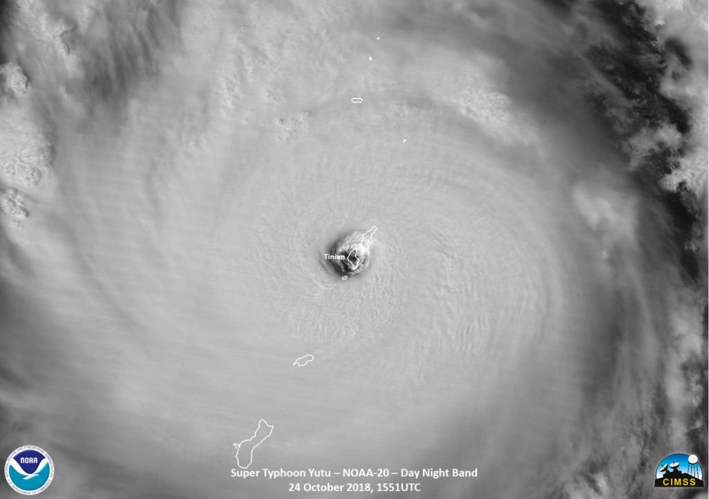
Shortly before the NOAA-20 satellite overpass on Oct. 23 (EDT) at 11:51 a.m. EDT (1551 UTC), Super typhoon Yutu hit Tinian island, one of the three principle islands of the Northern Mariana Islands, just south of Sapian and a U.S. Commonwealth. The southern part of Saipan is also impacted as well, which is where Saipan International Airport is located. Credit: NOAA/UWM-CIMSS, William Straka III
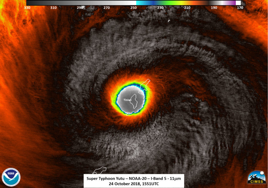
Shortly before the NOAA-20 satellite overpass on Oct. 23 (EDT) at 11:51 a.m. EDT (1551 UTC), Super typhoon Yutu hit Tinian Island, one of the three principle islands of the Northern Mariana Islands, just south of Sapian and a U.S. Commonwealth. Tinian is one of the three principal islands of the Commonwealth of the Northern Marianas. The southern part of Saipan was also impacted as well, where Saipan International Airport is located. A NOAA-20 infrared image showed coldest storm top temperatures around the eyewall at 210 kelvin (minus 81.6 Fahrenheit/minus 63.5 degrees Celsius) where storms are dropping extremely heavy rainfall.
NASA and the Japan Aerospace Exploration Agency’s GPM or Global Precipitation Measurement mission core satellite provided a look at heavy rainfall occurring in Super Typhoon Yutu on Oct. 24 at 10:50 a.m. EDT (1450 UTC) as it was battering Tinian and Saipan in the Northwestern Pacific Ocean.
At 11 a.m. EDT (1500 UTC) on Oct. 24 (1 a.m. CHST Oct. 25) the center of Super Typhoon Yutu will be located near Latitude 14.8 degrees North and Longitude 145.7 degrees East. That’s about 15 miles south-southeast of Tinian. Yutu is moving northwest at 13 mph. The eye of Yutu will pass over Tinian over the next couple hours. Maximum sustained winds have increased to 180 mph. Super Typhoon Yutu is a very dangerous Category 5 storm.
Typhoon force winds extend outward from the center up to 85 miles. Tropical storm force winds extend outward from the center up to 240 miles to the northeast and up to 205 miles elsewhere.
Shortly before the NOAA-20 satellite overpass on Oct. 23 (EDT) at 11:51 a.m. EDT (1551 UTC), Super typhoon Yutu hit Tinian island, one of the three principle islands of the Northern Mariana Islands, just south of Sapian and a U.S. Commonwealth. This infrared image shows coldest storm top temperatures around the eyewall at 210 kelvin where storms are dropping extremely heavy rainfall. Credit: NOAA/UWM-CIMSS, William Straka III
NWS said about storm surge and storm tide: Combined seas between 30 and 40 feet near the center of the storm will continue through tonight…resulting in deadly surf conditions. Coastal inundation of 15 to 20 feet is possible on windward exposures. Once Yutu passes to the west of the Mariana Islands…west and southwest swell will build with surf rising to 12 to 16 feet along west facing reefs. Coastal inundation of 5 to 7 feet is possible on west facing exposures. Surf will generate deadly rip currents.
A flash flood warning remains in effect for the entire area. Additional rainfall amounts of 6 to 10 inches are possible today. Isolated total rainfall amounts of up to 15 inches are possible.
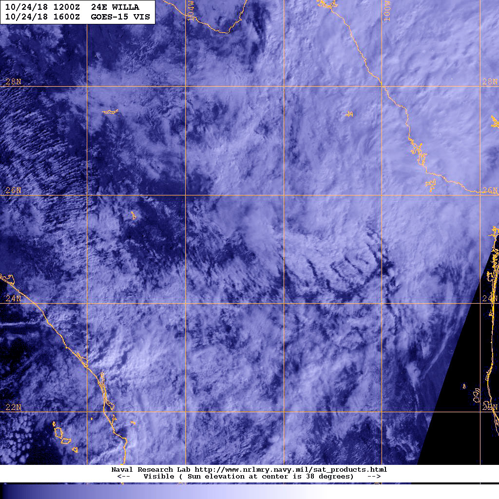
Satellite data showed a shapeless area of clouds over northeastern Mexico on Oct. 24 where former hurricane Willa has dissipated. NOAA’s GOES-West satellite captured a visible image of Willa’s remnant clouds.
NOAA’s GOES-West satellite provided a visible image of Willa’s remnant clouds. Satellite images and surface observations indicate that Willa’s surface circulation has dissipated over northeastern Mexico. Credit: NOAA/NASA
On Oct. 24 at 12 p.m. EDT (1600 UTC), NOAA’s GOES-West satellite provided a visible image of Willa’s remnant clouds. Satellite images and surface observations indicate that Willa’s surface circulation has dissipated over northeastern Mexico.
At 11 a.m. EDT (1500 UTC), the remnants of Willa were located near latitude 25.5 degrees north and longitude 101.5 degrees west. That’s about 75 miles (120 km) west of Monterrey Mexico. The remnants are moving toward the northeast near 28 mph (44 kph) and this general motion is expected to continue today. Maximum sustained winds had decreased to near 25 mph (35 kph) with higher gusts. The estimated minimum central pressure is 1008 millibars.
The National Hurricane Center noted “A non-tropical cyclone that is forecast to move from the Gulf of Mexico to the northeastern United States over the next few days is a separate system, and not directly associated with Willa’s remnants.”
Tropical Storm Vicente made landfall and weakened quickly to a tropical depression on Oct. 23. NOAA’s GOES-West satellite captured a visible image of the fading, and now post-tropical storm raining on southwestern Mexico.
On Oct. 23 at 2 p.m. EDT (1800 UTC), NOAA’s GOES-West satellite provided a visible image of Vicente. The storm appeared almost shapeless, but there was a larger concentration of thunderstorms near its circulation center. Vicente degenerated into a remnant low while moving inland over the Mexican state of Michoacan. Credit: NOAA/NRL
On Oct. 23 at 2 p.m. EDT (1800 UTC), NOAA’s GOES-West satellite provided a visible image of Vicente. The storm appeared almost shapeless, but there was a larger concentration of thunderstorms near its circulation center. Vicente degenerated into a remnant low while moving inland over the Mexican state of Michoacan.
At 11 a.m. EDT (1500 UTC), the center of Post-Tropical Cyclone Vicente was located near latitude 18.4 degrees north, longitude 102.4 degrees west. The post-tropical cyclone is moving toward the north-northwest near 12 mph (19 kph) and this general motion is expected to continue today, bringing the system farther inland over Mexico. Maximum sustained winds have decreased to near 30 mph (45 kph) with higher gusts. The system is expected to dissipate later today. The estimated minimum central pressure is 1008 millibars.
Despite weakening, the NHC cautioned that Vicente’s remnants are expected to produce 3 to 6 inches of rain with local amounts to 10 inches through today, Oct. 23, over portions of Guerrero, Michoacan, Colima, and Jalisco in Mexico. This rainfall could produce life-threatening flash flooding and landslides within mountainous terrain.
Oct. 23, 2018 – NASA Eyes Powerful Hurricane Willa Affecting Western Mexico
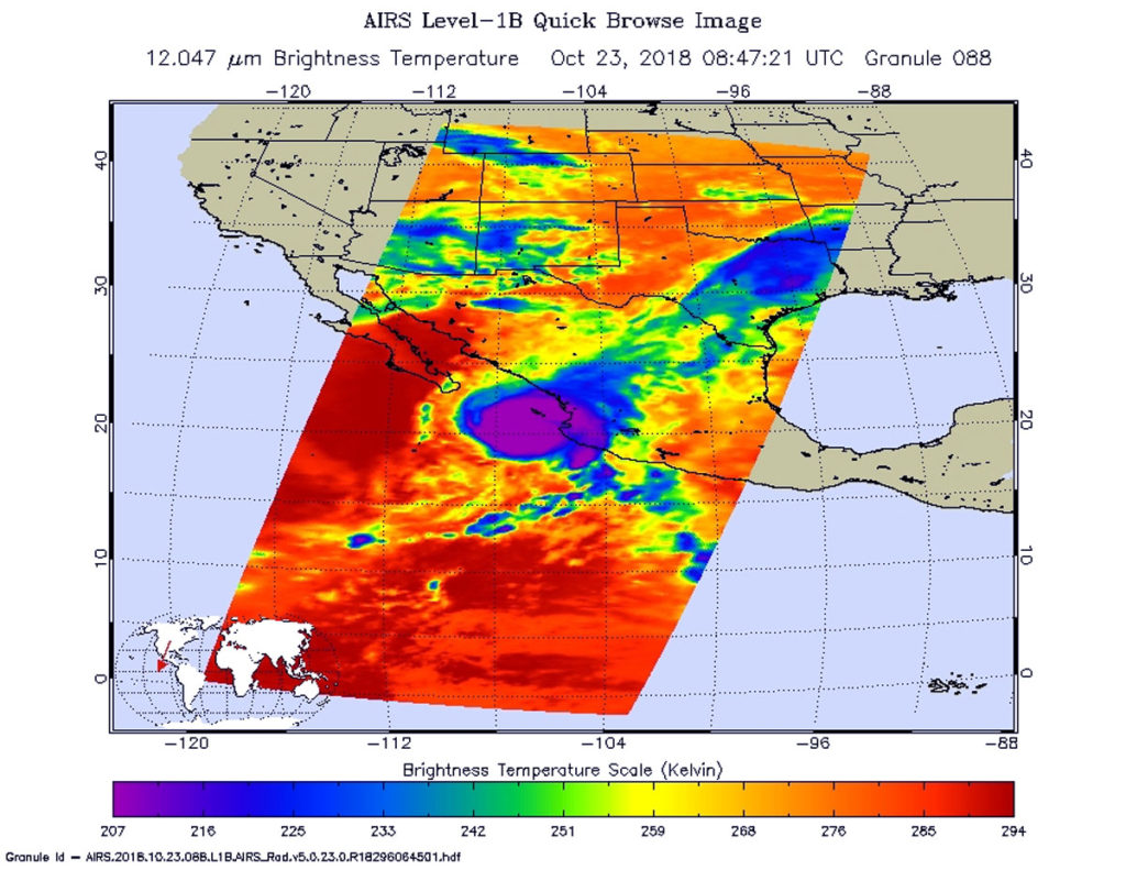
NASA’s Aqua satellite provided an infrared view of Hurricane Willa as it continued moving toward landfall in western Mexico on Oct. 23. NASA-NOAA’s Suomi NPP satellite provided a visible look at the extent and structure of the storm. Willa is expected to bring life-threatening storm surge, wind, and rainfall to portions of west-central and southwestern Mexico.
NASA’s Aqua satellite passed over Hurricane Willa on Oct. 23 at 4:47 a.m. EDT (0847 UTC) and analyzed it in infrared light. Powerful storms (purple) with very cold cloud top temperatures circled the center and stretched northeast over western Mexico. Credit: NASA JPL, Heidar Thrastarson
NASA Satellite Imagery Reveal
On Oct. 22, NASA-NOAA’s Suomi NPP satellite captured a visible image of Hurricane Willa when it was battering western Mexico with heavy rainfall, rough surf and strong winds. The image showed powerful thunderstorms circling a cloud-filled eye and the storm stretched from Sinaloa state south to Michoacan state.
NASA’s Aqua satellite passed over Hurricane Willa on Oct. 23 at 4:47 a.m. EDT (0847 UTC) and the Atmospheric Infrared Sounder or AIRS instrument aboard analyzed cloud top temperatures using infrared light. Coldest cloud top temperatures were as cold as or colder than 208 Kelvin or minus 85.2 degrees Fahrenheit (minus 65.1 Celsius). Cloud top temperatures that cold indicate strong storms that have the capability to create heavy rain.
Watches and Warnings on Oct. 23, 2018
A Hurricane Warning is in effect for San Blas to Mazatlan, including Las Islas Marias. A Tropical Storm Warning is in effect for Playa Perula to San Blas and north of Mazatlan to Bahia Tempehuaya.
On Oct. 22, NASA-NOAA’s Suomi NPP satellite captured a visible image of Hurricane Willa when it was battering western Mexico with heavy rainfall, rough surf and strong winds. The image shows powerful thunderstorms circling a cloud-filled eye. Willa is expected to come ashore on Oct. 23. Credit: NASA Worldview, Earth Observing System Data and Information System (EOSDIS) /NOAA
Status of Hurricane Willa on Oct. 23 at 11 a.m. EDT
At 11 a.m. EDT on Oct. 23, NOAA Hurricane Hunter Aircraft found that the center of Hurricane Willa was passing over Las Islas Marias, Mexico. The center of Hurricane Willa was located near latitude 21.4 degrees north and longitude 106.9 degrees west. Willa is moving toward the north-northeast near 6 mph (9 kph). A faster motion toward the northeast is expected by this evening. Maximum sustained winds are near 125 mph (205 kph) with higher gusts. Willa is a category 3 hurricane on the Saffir-Simpson Hurricane Wind Scale. Hurricane-force winds extend outward up to 40 miles (65 km) from the center and tropical-storm-force winds extend outward up to 125 miles (205 km).
The National Hurricane Center noted “While gradual weakening is forecast today, Willa is expected to be a dangerous hurricane when it reaches the coast of Mexico. Rapid weakening is expected after landfall tonight and continuing into Wednesday (Oct. 24).
On the forecast track, the center of Willa will make landfall within the hurricane warning area along the west-central coast of mainland Mexico this evening.”
Oct. 23, 2018 – NASA-NOAA’s Suomi NPP Satellite Catches Typhoon Yutu Strengthening, Guam on Alert
Tropical Storm Yutu continued strengthening as NASA-NOAA’s Suomi NPP satellite passed overhead. On Oct. 23, Yutu was a strengthening typhoon east of Guam.
On Oct. 22 NASA-NOAA’s Suomi NPP satellite captured a visible image of Typhoon Yutu when it was east of Guam and its southern quadrant was affecting the Federated States of Micronesia. Credit: NASA Worldview, Earth Observing System Data and Information System (EOSDIS) /NOAA
On. Oct. 22, the Visible Infrared Imaging Radiometer Suite (VIIRS) instrument aboard NASA-NOAA’s Suomi NPP satellite passed over the western Pacific Ocean and captured a visible image of Yutu. VIIRS revealed a well-organized storm, and showed powerful thunderstorms around the center of circulation and in thick bands spiraling into the center from the northern and southern quadrants. At the time Suomi NPP passed overhead, Yutu was east of Guam and its southern quadrant was affecting the Federated States of Micronesia. The VIIRS image showed that the storm is about 400 miles in diameter.
On Oct. 23, NOAA’s National Weather Service (NWS) in Tiyan, Guam noted several warnings and watches. Typhoon warnings remain in effect for Rota, Tinian and Saipan. A Tropical Storm Warning is now in effect for Guam. A tropical storm watch remain in effect for Alamagan, Pagan, and Agrihan.
At 10 p.m. CHST local time (8 a.m. EDT /1200 UTC) on Oct. 23 the center of Typhoon Yutu was located near latitude 12.0 degrees north and longitude 149.6 degrees east.
That’s about 330 miles east-southeast of Rota and about 335 miles southeast of Saipan. Yutu is moving west at 10 mph. It is expected to maintain this general course and speed over the next 24 hours. Maximum sustained winds have increased to 90 mph. Yutu is forecast to intensify through Wednesday, Oct. 24.Typhoon force winds extend outward from the center up to 60 miles. Tropical storm force winds extend outward from the center up to 200 miles to the northeast and up to 155 miles elsewhere.
Typhoon conditions are expected Wednesday night through Thursday morning (local time) at Tinian and Saipan. Typhoon conditions are expected for Rota Wednesday afternoon through Thursday. Tropical storm conditions are expected for Guam late Wednesday afternoon through Thursday. Tropical storm conditions are possible within the next 24 to 36 hours at Alamagan, Pagan, and Agrihan.
NWS said “The current track has shifted slightly south and now brings Yutu just south of Tinian and Saipan as a 130 mph category 4 storm, late Wednesday night or early Thursday morning.”
Oct. 22, 2018 – Dangerous Hurricane Willa Probed By NASA and Japan’s GPM Satellite
Hurricane Willa is a major hurricane threatening western Mexico. Forecasters were able to see the rate of rainfall occurring within the powerful storm when the Global Precipitation Measurement mission or GPM’s core satellite passed overhead and provided that data.
GPM passed above Willa on October 21, 2018 at 3:51 p.m. EDT (1951 UTC). The location of precipitation in Willa’s well defined eye wall was made evident by GPM’s radar (DPR Ku Band). DPR indicated that a few powerful convective storms within Willa were dropping rain at a rate of over 6.3 inches (160 mm) per hour. Credit: NASA/JAXA, Hal Pierce
On Oct. 22, the National Hurricane Center or NHC noted that “Will became a potentially catastrophic category 5 hurricane on the Saffir-Simpson hurricane wind scale and is expected to produce life-threatening storm surge, wind, and rainfall over portions of west-central and southwestern Mexico.”
Willa’s Rapid History
Willa formed on Saturday, Oct. 20 and quickly became a tropical storm. By 5 p.m. EDT, Willa strengthened into a major hurricane and continued to strengthen.
Hurricane Willa was a Category 4 hurricane and moving northward toward the western coast of Mexico when the GPM core observatory passed above on October 21, 2018 at 3:51 p.m. EDT (1951 UTC). At that time, the hurricane had maximum sustained winds of about 95 mph (109 knots).
GPM Satellite Provides Rainfall Rates
GPM’s Microwave Imager (GMI) and Dual-Frequency Precipitation Radar (DPR) instruments collected data showing that hurricane Willa and feeder bands were producing heavy rainfall over a large area. The location of precipitation in Willa’s well defined eye wall was made evident by GPM’s radar (DPR Ku Band). DPR indicated that a few powerful convective storms within Willa were dropping rain at a rate of over 6.3 inches (160 mm) per hour.
GPM passed above Willa on October 21, 2018 at 3:51 p.m. EDT (1951 UTC). The location of precipitation in Willa’s well defined eye wall was made evident by GPM’s radar (DPR Ku Band). DPR indicated that a few powerful convective storms within Willa were dropping rain at a rate of over 6.3 inches (160 mm) per hour. GPM’s radar shows that a few powerful storms in the eye of the hurricane were reaching heights above 8.7 miles (14.0 km). Credit: NASA/JAXA, Hal Pierce
At NASA’s Goddard Space Flight Center in Greenbelt, Md. a simulated 3-D view was created of the storm looking from the south-southeast reveals hurricane Willa’s rainfall structure. It was developed using GPM’s radar data (DPR Ku Band). That DPR data enabled a cross-section view that shows the anatomy of precipitation around hurricane Willa’s eye. Intense radar echoes of up to 57dBZ are shown (dark red) in this slice through the center of the intensifying hurricane. GPM’s radar shows that a few powerful storms in the eye of the hurricane were reaching heights above 8.7 miles (14.0 km). These tall storms referred to as “hot towers” are often an indication of hurricane intensification. These powerful convective storms near the center of the hurricane were releasing energy in the form of latent heat of condensation that powers the hurricane.
GPM is a joint mission between NASA and JAXA, the Japan Aerospace Exploration Agency.
Willa’s Expected Rainfall
The National Hurricane Center said “Willa is expected to produce storm total rainfall accumulations of 6 to 12 inches, with local amounts to 18 inches, across portions of western Jalisco, western Nayarit, and southern Sinaloa in Mexico. This rainfall will cause life-threatening flash flooding and landslides. Farther inland, Willa is expected to produce rainfall amount of 2 to 4 inches across portions of Zacateca, Durango, southeast Chihuahua, and Coahuila in Mexico, with local amounts to 6 inches possible. This rainfall could cause life-threatening flash flooding.”
Warnings and Watches in Effect on Oct. 22
A Hurricane Warning is in effect for San Blas to Mazatlan, including Las Islas Marias. A Tropical Storm Warning is in effect for Playa Perula to San Blas and north of Mazatlan to Bahia Tempehuaya.
GPM passed above Willa on October 21, 2018 at 3:51 p.m. EDT (1951 UTC). The location of precipitation in Willa’s well defined eye wall was made evident by GPM’s radar (DPR Ku Band). DPR indicated that a few powerful convective storms within Willa were dropping rain at a rate of over 6.3 inches (160 mm) per hour. GPM’s radar shows that a few powerful storms in the eye of the hurricane were reaching heights above 8.7 miles (14.0 km). Click to see 3-D flyby animation. Credit: NASA/JAXA, Hal Pierce
Status of Willa on Oct. 22
At 11 a.m. (1500 UTC) on Oct. 22 the center of Hurricane Willa was located near latitude 19.1 degrees north, longitude 107.2 degrees west. About 175 miles (280 km) south-southwest of Las Islas Marias Mexico. Willa is moving toward the north near 7 mph (11 kph), and this general motion is expected to continue today.
Satellite data indicate that the maximum sustained winds have increased to near 160 mph (260 kph) with higher gusts. Willa is a category 5 hurricane on the Saffir-Simpson Hurricane Wind Scale.
Some strengthening is still possible today. Slight weakening is forecast to begin on Tuesday, but Willa is expected to be an extremely dangerous major hurricane when it reaches the coast of Mexico. Hurricane-force winds extend outward up to 30 miles (45 km) from the center and tropical-storm-force winds extend outward up to 105 miles (165 km).
The National Hurricane Center (NHC) predicts Willa to accelerate toward the north-northeast and move over or very near the Islas Marias early Tuesday and make landfall along the southwestern coast of mainland Mexico in the hurricane warning area Tuesday afternoon or evening.
For details on Storm Surge, Wind and Surf, visit: www.nhc.noaa.gov.
NASA-NOAA’s Suomi NPP satellite passed over the Northwestern Pacific Ocean and captured a visible image of Tropical Storm Yutu as warnings were posted. A typhoon watch is in force for Tinian and Saipan and a tropical storm watch is in force for Rota.
On Oct. 21 NASA-NOAA’s Suomi NPP satellite captured a visible image of Tropical Storm Yutu, north of Papau New Guinea and east of Guam. Credit: NASA Worldview, Earth Observing System Data and Information System (EOSDIS) /NOAA
The National Weather Service in Tiyan, Guam noted that residents of Guam, Alamagan, Pagan and Agrihan should continue to monitor the progress of Tropical Storm Yutu.
Tropical Depression 31 developed on Monday, Oct. 22 at 2 a.m. CHST (Guam local time) and rapidly intensified into a tropical storm.
On Oct. 22, the Visible Infrared Imaging Radiometer Suite (VIIRS) instrument aboard NASA-NOAA’s Suomi NPP satellite passed over Yutu and captured a visible image of the storm. VIIRS showed an organized storm with strong thunderstorms circling the center and in bands feeding into the center from the south and east.
At 1 a.m. CHST (local time) on Oct. 23 (11 a.m. EDT/1500 UTC on Oct. 22) the center of Tropical Storm Yutu was located near latitude 10.9 degrees north and longitude 153.3 degrees east. That’s about 255 miles north-northeast of Chuuk and about 585 miles east-southeast of Saipan.
Maximum sustained winds have increased to 50 mph. Yutu will continue to intensify through Wednesday, possibly becoming a typhoon later today. Tropical storm force winds extend outward from the center up to 80 miles to the southwest and up to 150 miles elsewhere.
Yutu is moving northwest at 16 mph and is expected to continue its northwest motion through Thursday, but the National Weather Service in Guam said its forward speed will decrease slightly today and tonight. This forecast keeps Yutu on a track that will pass just north of Saipan late Wednesday night or Thursday morning, Oct. 24 local time.
Oct. 22, 2018 – NASA Sees Tiny Tropical Storm Vicente Near Southwestern Mexico’s Coast
NASA-NOAA’s Suomi NPP satellite passed over the Eastern Pacific Ocean and captured a visible image of the small tropical storm named Vicente.
On Oct. 21 NASA-NOAA’s Suomi NPP satellite captured a visible image of Tropical Storm Vicente that showed it was a small storm. Credit: NASA Worldview, Earth Observing System Data and Information System (EOSDIS) /NOAA
Vicente developed on Friday, Oct. 19 as Tropical Depression Twenty-Three-E (TD 23E). TD23E formed about 85 miles (135 km) west-southwest of Puerto San Jose Guatemala and moved west-northwest while intensifying. Later in the day TD23E strengthened into a tropical storm and was renamed Vicente, but the storm was moving slowly. Because of the slow movement, heavy rains fell over portions of El Salvador, Guatemala and southeastern Mexico. Vicente then moved west
On. Oct. 21, the Visible Infrared Imaging Radiometer Suite (VIIRS) instrument aboard NASA-NOAA’s Suomi NPP satellite passed over Vicente and captured a visible image of the storm. VIIRS showed that the storm was small in diameter. Tropical-storm-force winds extend outward up to 45 miles (75 km) from the center. Vicente appeared less organized in the image than it did hours earlier.
On Oct. 22 at 11 a.m. EDT (1500 UTC) NOAA’s National Hurricane Center (NHC) in Miami, Fla. noted that the center of Tropical Storm Vicente was located near latitude 14.9 degrees north and longitude 100.8 degrees west. Vicente is moving toward the west-northwest near 12 mph (19 kph) and a turn to the northwest is expected today followed by a turn to the north-northwest on Tuesday, Oct. 23. Maximum sustained winds are near 45 mph (75 kph) with higher gusts. Weakening is forecast, and Vicente is expected to become a tropical depression by tonight or Tuesday.
On Oct. 22 although there are no coastal watches or warnings in effect, the NHC cautioned that interests along the southern and southwestern coasts of Mexico should monitor the progress of Vicente. On the forecast track, the center of Vicente is expected to approach the southwestern coast of Mexico on Tuesday, Oct. 23. The cyclone’s circulation is expected to dissipate near the southwestern coast of Mexico by Wednesday, Oct. 24.