Vayu (was 02A) – Northern Indian Ocean

June 17 Update – NASA-NOAA Satellite Finds Dry Air Affecting Tropical Cyclone Vayu

Tropical Cyclone Vayu was fading as it neared the coast of southwestern Pakistan and northwestern India. Dry air and wind shear were preventing development the development of thunderstorms, making the clouds on the storm’s western side appear wispy in an image from NASA-NOAA’s Suomi NPP satellite.
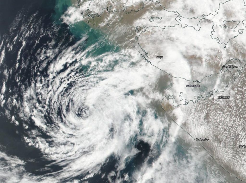
satellite image of Vayu
NASA-NOAA’s Suomi NPP satellite passed over the Arabian Sea on June 17 and saw the effects of dry air on Tropical Cyclone Vayu’s western quadrant where only wispy clouds were seen. Credit: NASA Worldview, Earth Observing System Data and Information System (EOSDIS).

The Visible Infrared Imaging Radiometer Suite (VIIRS) instrument aboard Suomi NPP provided a visible image of the storm on June 17, 2019. The VIIRS image showed that dry air that moved into the storm on the western side had prevented further development of the thunderstorms that make up a tropical cyclone. Clouds on that side of Vayu appeared wispy and were precipitation free. Thicker clouds were visible on Vayu’s eastern side where some had already spread over the coast of northwestern Indian near Naliya. Vayu is forecast to make landfall near Naliya later in the day.

On June 17 at 0300 UTC (June 16 at 11 p.m. EDT), the Joint Typhoon Warning Center issued the final warning on Vayu. At that time, Tropical Cyclone Vayu was located near 21.8 degrees north latitude and 66.8 degrees east longitude, approximately 180 nautical miles south of Karachi, Pakistan. Vayu was moving to the northeast and had maximum sustained winds near 35 knots (40 mph/65 kph) making it a minimal tropical storm.

In addition to dry air sapping the tropical cyclone’s ability to create more thunderstorms, wind shear is pushing the remaining storms to the east of the center.

In general, wind shear is a measure of how the speed and direction of winds change with altitude. Tropical cyclones are like rotating cylinders of winds. Each level needs to be stacked on top each other vertically in order for the storm to maintain strength or intensify. Wind shear occurs when winds at different levels of the atmosphere push against the rotating cylinder of winds, weakening the rotation by pushing it apart at different levels.

Vayu is forecast to dissipate later in the day on June 17.

By Rob Gutro
NASA’s Goddard Space Flight Center  

02A (Northern Indian Ocean)

June 10, 2019 – NASA Catches Development of Tropical Cyclone 02A

Visible imagery from NASA’s Terra satellite provided confirmation of the development of Tropical Cyclone 02A in the Arabian Sea, Northern Indian Ocean.

Terra image of 02A
On June 10, 2019, the MODIS instrument aboard NASA’s Terra satellite provided a visible image of Tropical Cyclone 02A in the Northern Indian Ocean, off the western coast of India. Credit: NASA Worldview, Earth Observing System Data and Information System (EOSDIS)

On June 10, the Moderate Resolution Imaging Spectroradiometer or MODIS instrument aboard NASA’s Terra satellite provided a visible image of 02A that showed thunderstorms circling the low-level center. MODIS imagery also showed some clouds and thunderstorms were offset to the northwest of the center. That’s a result of outside winds or vertical wind shear, blowing from the southeast and pushing some clouds to the northwest.

Satellite imagery revealed that the sea surface temperatures are warm enough to support further development of Tropical Cyclone 02A, and forecasters at the Joint Typhoon Warning Center expect some strengthening over the next couple of days.

At 11 a.m. EDT (1500 UTC) on Monday, June 10, 2019, Tropical Cyclone 02A was centered near 13.7 degrees north latitude and 70.8 east longitude. That puts the center about 350 nautical miles south-southwest of Mumbai, India. 02A was moving to the north-northwest at 8 knots (9 mph/15 kph). Maximum sustained winds were near 45 knots (52 mph/83 kph).

The Joint Typhoon Warning Center forecast noted that the storm is expected to peak on June 12 when maximum sustained winds reach 60 knots (69 mph/111 kph). ”The cyclone is expected to continue tracking generally northward along the western periphery of a subtropical ridge (elongated area of high pressure) anchored over India, making landfall near Jamnagar around 96 hours [June 14] and track inland.”

By Rob Gutro
NASA’s Goddard Space Flight Center