Podul (was 13W) – Northwestern Pacific Ocean

Aug. 29, 2019 – NASA Tracks Tropical Storm Podul’s Landfall Approach to Vietnam

NASA’s Aqua satellite passed over the South China Sea and provided forecasters with a visible image of Tropical Storm Podul as it moved closer to the coast of north and central Vietnam where it is expected to make landfall on August 29.

Aqua image of Podul
On Aug. 29, 2019 at 2 a.m. EDT (0600 UTC), the MODIS instrument aboard NASA’s Aqua satellite provided a visible image of Podul in the South China Sea. Podul had already started its landfall in central Vietnam and appeared somewhat elongated. Credit: NASA/NRL

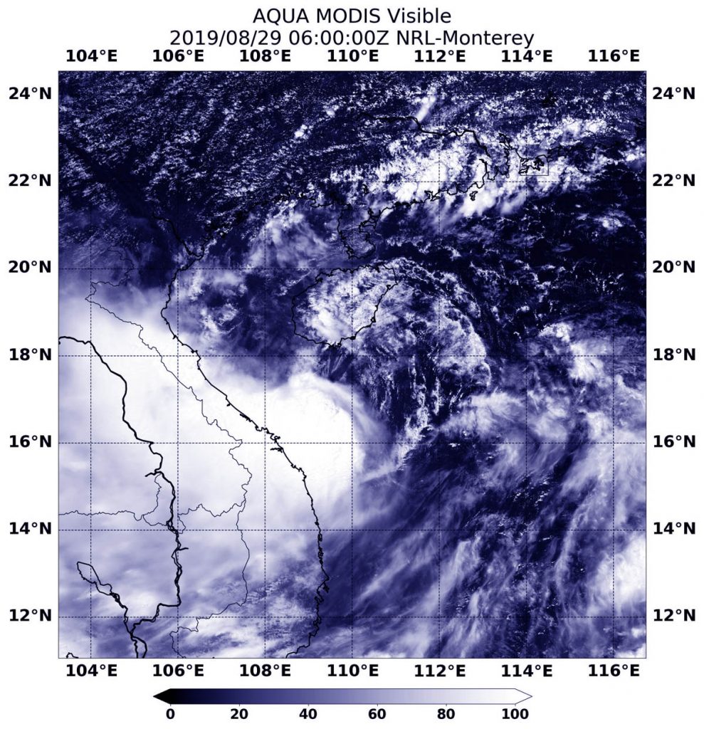
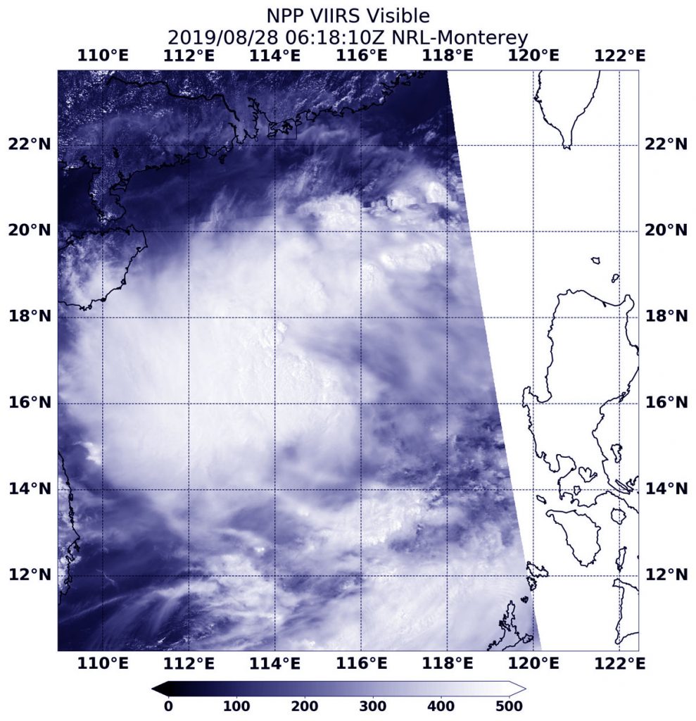
On Aug. 29, 2019 at 2 a.m. EDT (0600 UTC), the Moderate Resolution Imaging Spectroradiometer or MODIS instrument aboard NASA’s Aqua satellite provided a visible image of Podul in the South China Sea. Podul had already started its landfall in central Vietnam and appeared somewhat elongated because northerly winds outside the storm are pushing clouds south of the center.

At 5 a.m. EDT (0900 UTC) on Aug. 29, Tropical storm Podul was centered near 17.8 degrees north latitude and 108.3 degrees east longitude, about 108 nautical miles north of Da Nang, Vietnam. Podul continued moving west and had maximum sustained winds 35 knots (40 mph/65 kph).

The Vietnam National Centre for Hydro-Meteorological Forecasting (NCHMF) is a governmental organization belonging Vietnam Meteorological Hydrological Administration (VMHA) with authority to issue forecasting/warning information for weather, climate, hydrology, water resource, marine weather (i.e. hydrometeorology) and provide hydro-meteorology services.  NHCMF has issued a Tropical Storm Warning for central Vietnam with the approach of Podul.

For updated warnings and forecasts from NCHMF, visit: http://www.nchmf.gov.vn/Web/en-US/104/102/18004/Default.aspx

By Rob Gutro
NASA’s Goddard Space Flight Center

Podul (was13W – Northwestern Pacific Ocean)

Aug. 28, 2019 – NASA-NOAA Satellite Finds Tropical Storm Podul Marching Through South China Sea

Tropical Storm Podul was moving through the South China Sea when NASA-NOAA’s Suomi NPP satellite passed overhead from space and snapped a visible image of the storm.

Suomi NPP image of Podul
NASA-NOAA’s Suomi NPP provided a visible image of Tropical Storm Podul on Aug. 28 at 2:18 a.m. EDT (0618 UTC). The image showed that the storm had encountered wind shear because the bulk of clouds were pushed west of the center. Credit: NASA/NRL

The Visible Infrared Imaging Radiometer Suite (VIIRS) instrument aboard Suomi NPP provided a visible image of the storm on Aug. 28 at 2:18 a.m. EDT (0618 UTC). The VIIRS image showed the storm was being affected by wind shear because much of the cloud cover and thunderstorms were being pushed west of the center. That left minimal clouds and storms east of center. The Joint Typhoon Warning Center noted, “The environment is marginal overall with unfavorably strong (25-30 knot) vertical wind shear.”

In general, wind shear is a measure of how the speed and direction of winds change with altitude. Tropical cyclones are like rotating cylinders of winds. Each level needs to be stacked on top each other vertically in order for the storm to maintain strength or intensify. Wind shear occurs when winds at different levels of the atmosphere push against the rotating cylinder of winds, weakening the rotation by pushing it apart at different levels.

At 11 a.m. EDT (1500 UTC) on Aug. 28, the Joint Typhoon Warning Center or JTWC noted that Tropical Storm Podul was centered near 17.2 degrees north latitude and 114.0 degrees east longitude. That’s about 336 nautical miles east-northeast of Da Nang, Vietnam. Podul was moving west toward Vietnam. Maximum sustained winds 35 knots (40 mph/65 kph).

Podul is expected to strengthen as it continues moving through the South China Sea, and will make landfall in northern Vietnam on Aug. 30.

By Rob Gutro 
NASA’s Goddard Space Flight Center

Podul (was 13W) – Northwestern Pacific Ocean

Aug. 27, 2019 – NASA-NOAA Satellite Tracks Tropical Depression Podul Across Philippines

Tropical Depression 13W, now named Podul, was crossing the Philippines from east to west as NASA-NOAA’s Suomi NPP satellite provided a visible image of the storm.

Suomi NPP image of Podul
On August 27, 2019, NASA-NOAA’s Suomi NPP satellite passed over the South China Sea and captured a visible image of Tropical Storm Podul. Credit: NASA Worldview, Earth Observing System Data and Information System (EOSDIS).

Podul’s trek across the country triggered many Philippines warnings on August 27, 2019. Tropical cyclone wind signal #2 is in effect over the following Luzon provinces:  Isabela, Aurora, Quirino, Nueva Vizcaya, Ifugao, Mountain Province, Ifugao, Benguet, Ilocos Sur, La Union and Pangasinan. Tropical cyclone wind signal #1 is in effect over the following Luzon provinces: Cagayan, Apayao, Abra, Kalinga, Ilocos Norte, Nueva Ecija, Tarlac, Zambales, Bataan, Pampanga, Bulacan, Metro Manila, Rizal, northern portion of Quezon including Polillo Island and Alabat Island, Cavite, Laguna, Camarines Norte, northeastern portion of Camarines Sur and Catanduanes.

The Visible Infrared Imaging Radiometer Suite (VIIRS) instrument aboard Suomi NPP provided a visible image of the storm on August 27, 2019. The VIIRS image showed the storm blanketed the country from north to south. The bulk of the clouds were located over the northern and central Philippines.

At 11 a.m. EDT (1500 UTC), Podul, known locally in the Philippines as “Jenny,” was located near 16.0 degrees north latitude and 123.2 degrees east longitude. That puts the center of circulation about 153 nautical miles northeast of Manila, Philippines. It was moving to the west-northwest and had maximum sustained winds near 30 knots (34.5 mph/55.5. kph).

The Joint Typhoon Warning Center said that Podul will move west across the Philippines, before turning northwest towards Hainan Island, China. The system is expected to make final landfall in Vietnam after five days.

By Rob Gutro 
NASA’s Goddard Space Flight Center

13W – Northwestern Pacific Ocean

Aug. 26, 2019 – NASA’s Terra Satellite Finds Some Power in Tropical Depression 13W

Infrared imagery from NASA’s Terra satellite revealed Tropical Depression 13W contained some powerful thunderstorms pushing high into the troposphere as it was moving west in the Philippine Sea toward the Philippines.

Terra image of 13W
On August 26 at 9:15 a.m. EDT (1315 UTC), the MODIS instrument that flies aboard NASA’s Terra satellite found strongest storms (yellow) had cloud top temperatures as cold as minus 80 degrees Fahrenheit (minus 62.2 Celsius). Credit: NASA/NRL

Tropical Depression 13W has already triggered warnings in the Philippines because it is located just east of the country. Philippines warnings include Tropical cyclone wind signal #1 over the following Luzon provinces: Cagayan, Isabela, Quirino, Nueva Vizcaya, Apayao, Abra, Kalinga, Mountain Province, Ifugao, Benguet, Aurora, Nueva Ecija, eastern portion of Pangasinan, northern portion of Quezon including Polillo Island and Catanduanes.

NASA’s Terra satellite used infrared light to analyze the strength of storms and found the most powerful thunderstorms stretching north over the center from west to east. Infrared data provides temperature information, and the strongest thunderstorms that reach high into the atmosphere have the coldest cloud top temperatures.

On August 26 at 9:15 a.m. EDT (1315 UTC), the Moderate Imaging Spectroradiometer or MODIS instrument that flies aboard NASA’s Terra satellite found those strongest storms had cloud top temperatures as cold as minus 80 degrees Fahrenheit (minus 62.2 Celsius). Cloud top temperatures that cold indicate strong storms with the potential to generate heavy rainfall.

At 11 a.m. EDT (1500 UTC), the center of Tropical Depression 13W was located near latitude 13.9 degrees north latitude and 128.5 degrees east longitude. That is about 498 nautical miles east of Manila, Philippines. 13W was moving toward the west and toward the Philippines. Maximum sustained winds are near 52 mph (45 knots/83 kph) with higher gusts.

The Joint Typhoon Warning Center expects 13W will move west across the Philippines, before turning northwest towards Hainan Island, China. The system will make final landfall in Vietnam after five days.

By Rob Gutro
NASA’s Goddard Space Flight Center