Bavi – Northwestern Pacific Ocean

Aug. 27, 2020 – NASA’s Terra Satellite Sees the End of Bavi

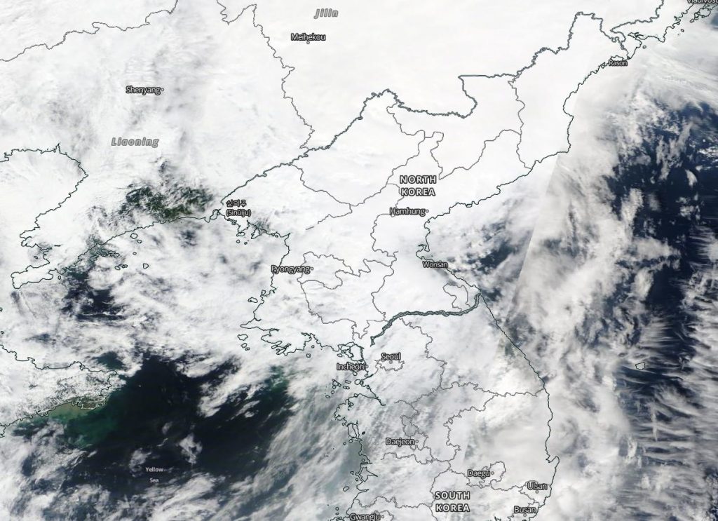
NASA’s Terra satellite captured visible imagery as Tropical Storm Bavi made landfall in northwestern North Korea and moved inland.
Terra image of Bavi
NASA’s Terra satellite provided a visible image to forecasters of Tropical Storm Bavi after it made landfall in northwestern North Korea on Aug. 27 and began moving into China. Image Courtesy: NASA Worldview, Earth Observing System Data and Information System (EOSDIS).

The Moderate Resolution Imaging Spectroradiometer or MODIS instrument that flies aboard NASA’s Terra satellite captured a visible image of Tropical Storm Bavi on Aug. 27. The image showed an almost shapeless tropical storm moving over North Korea and into China.

The final warning from the Joint Typhoon Warning Center was issued at 5 a.m. EDT (0900 UTC) on Aug. 27. At the time, it was located near latitude 41.6 degrees north and longitude 125.8 degrees east, about 249 nautical miles north of Inchon, South Korea. Bavi had weakened to a tropical storm with maximum sustained winds near 40 knots (46 mph/74 kph). It was moving to the north-northeast.

Bavi is quickly becoming extra-tropical after making landfall and is now moving across northeastern China.

When a storm becomes extra-tropical, it means that a tropical cyclone has lost its “tropical” characteristics. The National Hurricane Center defines “extra-tropical” as a transition that implies both poleward displacement (meaning it moves toward the north or south pole) of the cyclone and the conversion of the cyclone’s primary energy source from the release of latent heat of condensation to baroclinic (the temperature contrast between warm and cold air masses) processes. It is important to note that cyclones can become extratropical and still retain winds of hurricane or tropical storm force.

NASA’s Terra satellite is one in a fleet of NASA satellites that provide data for hurricane research.

Tropical cyclones/hurricanes are the most powerful weather events on Earth. NASA’s expertise in space and scientific exploration contributes to essential services provided to the American people by other federal agencies, such as hurricane weather forecasting.

By Rob Gutro
NASA’s Goddard Space Flight Center

Bavi – Northwestern Pacific Ocean

Aug. 26, 2020 – NASA Sees Typhoon Bavi from One Million Miles Away

Typhoon Bavi is a large storm moving through the Yellow Sea. A NASA camera captured an image of the Northwestern Pacific Ocean that showed Bavi headed north.

EPIC image of Bavi
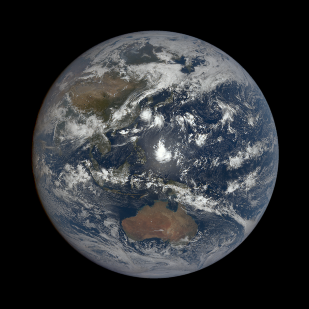
Typhoon Bavi was moving through the Yellow Sea on Aug. 25, 2020 when an image of it was captured from 1 million miles away. This full-disk image of the Earth was taken by NASA’s EPIC Camera aboard NOAA’s DSCOVR satellite. Credit: NASA/NOAA

NASA’s Earth Polychromatic Imaging Camera (EPIC), a four megapixel CCD camera and telescope aboard NOAA’s DSCOVR satellite in orbit 1 million miles from Earth, captured a full disk image of the Northwestern Pacific Ocean side of the globe. Typhoon Bavi was moving through the Yellow Sea on Aug. 25, 2020 when the image of it was captured.

EPIC maintains a constant view of the fully illuminated Earth as it rotates, providing scientific observations of ozone, vegetation, cloud height and aerosols in the atmosphere.  DSCOVR is a partnership between NASA, NOAA and the U.S. Air Force with the primary objective of maintaining the nation’s real-time solar wind monitoring capabilities, which are critical to the accuracy and lead time of space weather alerts and forecasts from NOAA.

On Aug. 26 at 4 a.m. EDT (0900 UTC), Typhoon Bavi was located near latitude 32.4 degrees north and longitude 124.5 degrees east. That is about 169 nautical miles east-southeast of Shanghai, China. Bavi has maximum sustained winds near 100 knots (115 mph/185 kph) and was moving to the north-northwest.

Bavi is moving north and the Joint Typhoon Warning Center noted the storm has reached peak intensity.  The storm is expected to weaken and start to become extra-tropical as it makes landfall in western North Korea and northeastern China.

For more information about DSCOVR, visit: http://www.nesdis.noaa.gov/DSCOVR

By Rob Gutro
NASA’s Goddard Space Flight Center

Bavi – Northwestern Pacific Ocean

Aug. 25, 2020 – NASA Finds Typhoon Bavi’s Strongest Side

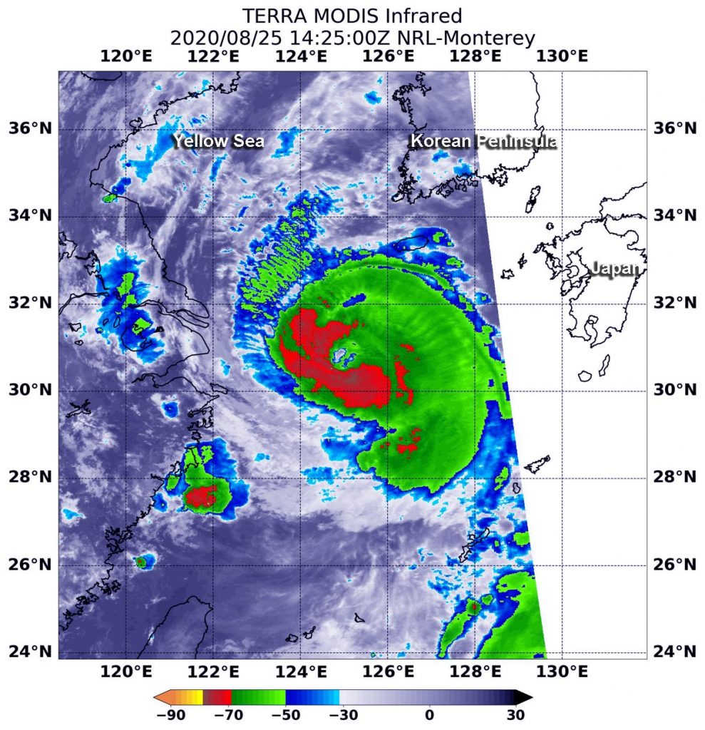
As Typhoon Bavi continued tracking north through the Yellow Sea, NASA’s Terra satellite used infrared light to identify strongest storms and coldest cloud top temperatures. The temperature data revealed that the strongest storms were not totally surrounding the eye.

Terra image of Bavi
On Aug. 25 at 10:25 a.m. EDT (1425 UTC), the MODIS instrument aboard NASA’s Terra satellite gathered temperature information about Hurricane Bavi’s cloud tops. MODIS found the most powerful thunderstorms (red) were west and south of the eyewall, where temperatures were as cold as or colder than minus 70 degrees Fahrenheit (minus 56.6 Celsius). Credit: NASA/NRL

Infrared Data Reveals Powerful Storms

On Aug. 25 at 10:25 a.m. EDT (1425 UTC), the Moderate Resolution Imaging Spectroradiometer or MODIS instrument aboard NASA’s Terra satellite gathered temperature information about Bavi’s cloud tops. Infrared data provides temperature information, and the strongest thunderstorms that reach high into the atmosphere have the coldest cloud top temperatures.

MODIS found the most powerful thunderstorms were west and south of the eyewall, where temperatures were as cold as or colder than minus 70 degrees Fahrenheit (minus 56.6 Celsius). Cloud top temperatures that cold indicate strong storms with the potential to generate heavy rainfall. Satellite data also showed that the eye was about 15 nautical miles wide.

Bavi’s Status  

At 11 a.m. EDT (1500 UTC) on Aug. 25, Typhoon Bavi was centered near latitude 30.6 degrees north and longitude 125.2 degrees east, about 274 nautical miles west-southwest of Sasebo, Japan. Bavi was moving to the north-northwest and had maximum sustained winds 95 knots (109 mph/176 kph).

Bavi is forecast to continue tracking in a northerly direction, moving through the Yellow Sea. It is expected to make landfall in extreme northwestern North Korea around Aug. 27 at 0000 UTC (Aug. 26 at 8 p.m. EDT).

NASA Researches Tropical Cyclones

Tropical cyclones/hurricanes are the most powerful weather events on Earth. NASA’s expertise in space and scientific exploration contributes to essential services provided to the American people by other federal agencies, such as hurricane weather forecasting.
By Rob Gutro
NASA’s Goddard Space Flight Center

Bavi – Northwestern Pacific Ocean

Aug. 24, 2020 – NASA-NOAA Satellite Find Typhoon Bavi Fill the East China Sea

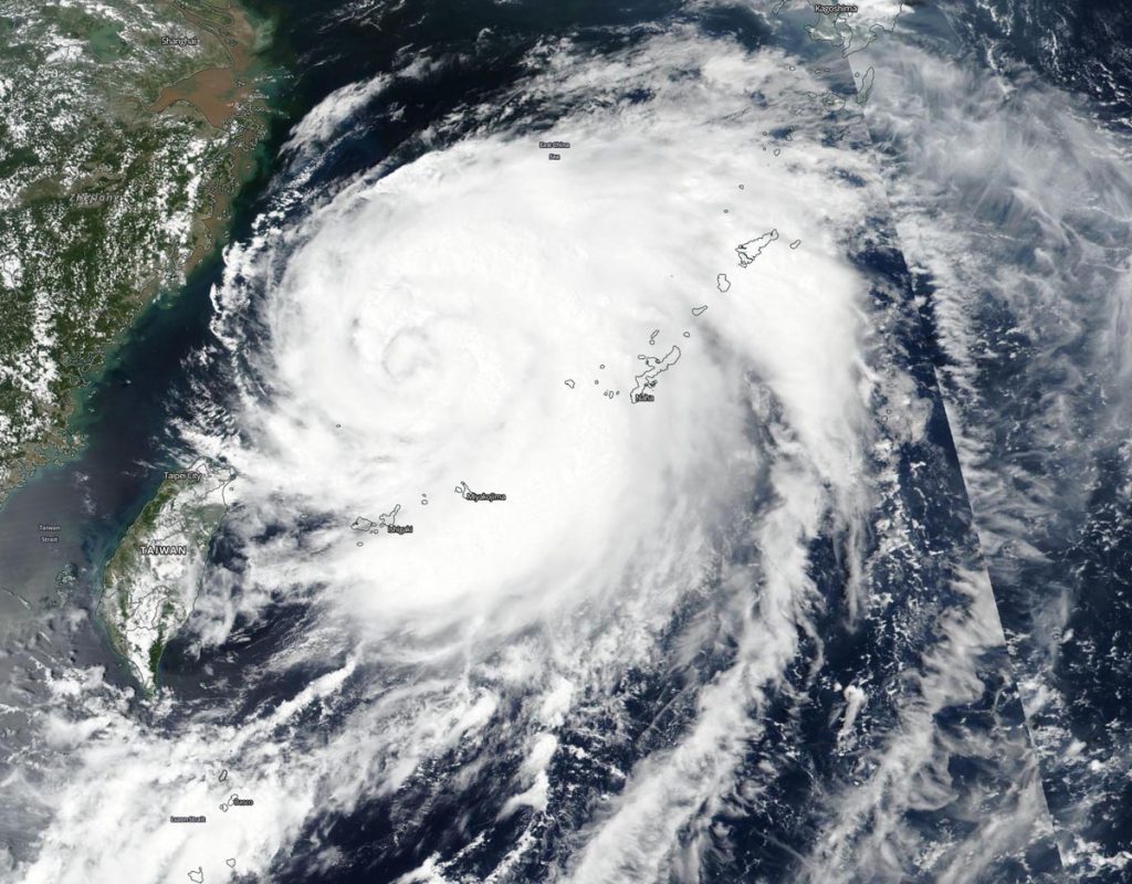
NASA-NOAA’s Suomi NPP satellite provided forecasters with a visible image of Typhoon Bavi filling up a good portion of the East China Sea.

Suomi NPP image of Bavi
NASA-NOAA’s Suomi NPP satellite provided forecasters with a visible image of Typhoon Bavi in the Northwestern Pacific Ocean on Aug. 24. Credit: NASA Worldview, Earth Observing System Data and Information System (EOSDIS)

Bavi’s life began as a tropical depression, 09W, that formed on Aug. 21 over 350 nautical miles from Kadena Air Base, Okinawa Island, Japan. On Aug. 22, when it strengthened into a tropical storm it was named Bavi. By 5 a.m. EDT (0900 UTC) on Aug. 23, the storm continued to strengthen and reached typhoon status when it was about 548 nautical miles south-southwest of Chinhae, South Korea.

On Aug. 24, the Visible Infrared Imaging Radiometer Suite (VIIRS) instrument aboard Suomi NPP provided a visible image of Bavi. It was located in the East China Sea, west of the chain of Ryukyu Islands. Powerful thunderstorms circled the eye, which was obscured by high clouds. Bands of thunderstorms from the storm’s eastern quadrant extended over the Ryukyu island chain.

At 5 a.m. EDT (0900 UTC) on Aug. 24, the center of Typhoon Bavi was located near latitude 27.8 degrees north and longitude 216.6 degrees east. Bavi is centered about 450 nautical miles south-southwest of Chinhae, South Korea. Bavi is moving to the northeast and had maximum sustained winds 75 knots (86 mph/139 kph).

Bavi is forecast to continue strengthening to 110 knots (127 mph/204 kph), before weakening rapidly on passing through the Yellow Sea and west of the Korean Peninsula. Bavi is expected to make landfall in northwestern North Korea on Aug. 26.

NASA Researches Tropical Cyclones

Hurricanes/tropical cyclones are the most powerful weather events on Earth. NASA’s expertise in space and scientific exploration contributes to essential services provided to the American people by other federal agencies, such as hurricane weather forecasting.
For more than five decades, NASA has used the vantage point of space to understand and explore our home planet, improve lives and safeguard our future. NASA brings together technology, science, and unique global Earth observations to provide societal benefits and strengthen our nation. Advancing knowledge of our home planet contributes directly to America’s leadership in space and scientific exploration.

By Rob Gutro 
NASA’s Goddard Space Flight Center