Chantal (Atlantic Ocean)

Aug. 23, 3019 – NASA’s Aqua Satellite Writing the End of Depression Chantal’s Story

Tropical Depression Chantal is winding down in the North Central Atlantic Ocean and that was confirmed by infrared data from NASA’s Aqua satellite on August 23.

On Aug. 23 at 12:45 a.m. EDT (0445 UTC), the MODIS instrument that flies aboard NASA’s Aqua satellite showed strongest storms (yellow) in Tropical Depression Chantal were in two small areas, east and west of center, where cloud top temperatures in those areas were as cold as minus 50 degrees Fahrenheit (minus 45.5 Celsius). Credit: NASA/NRL

The National Hurricane Center or NHC forecasts the end of Chantal’s life story later in the day, as the storm is forecast to become a remnant low pressure area.

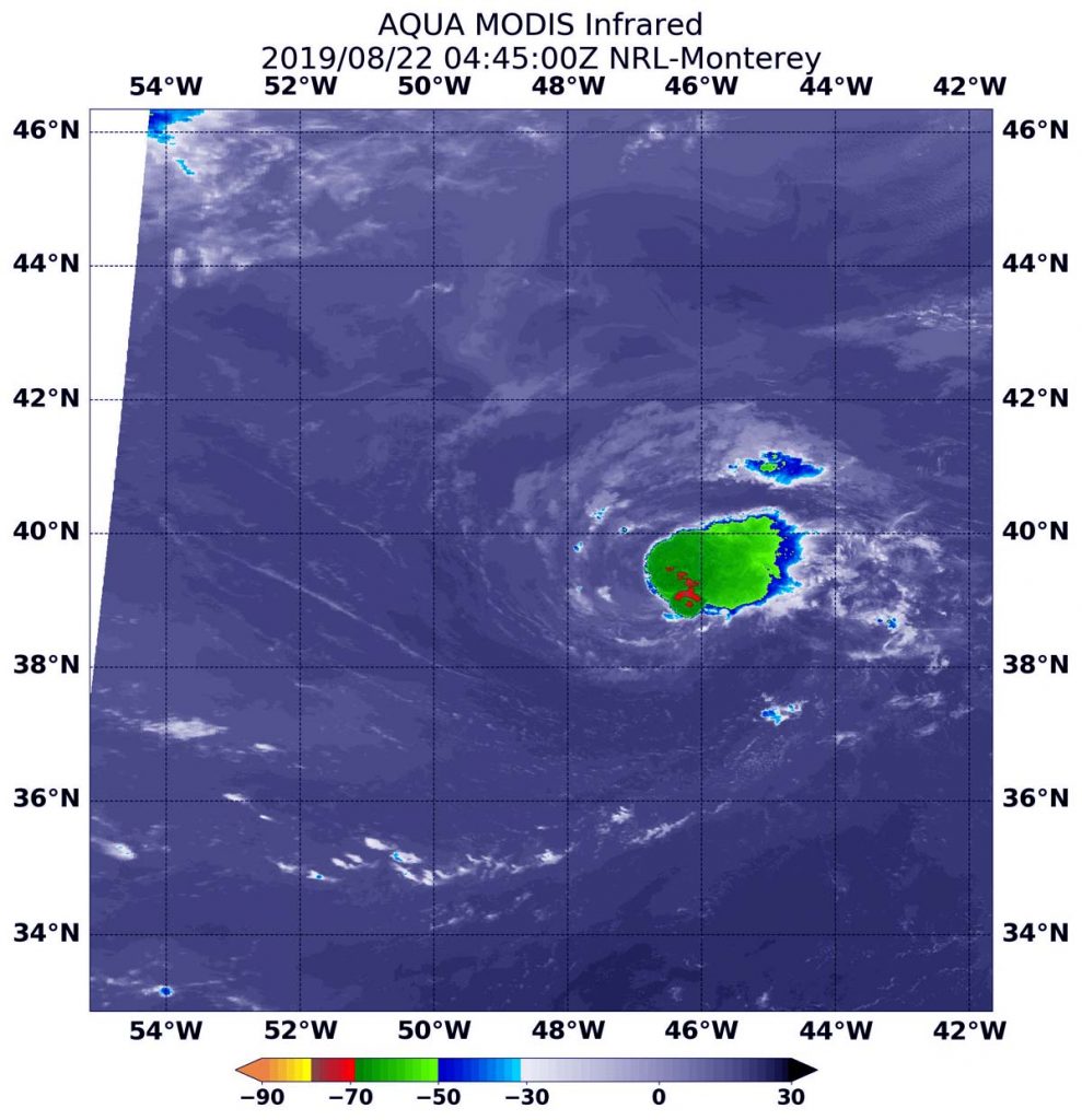
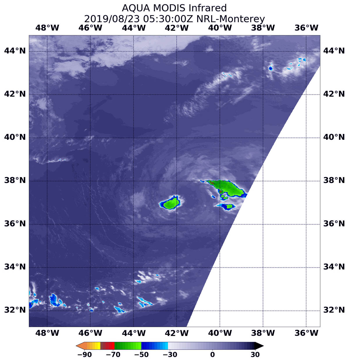
On Aug. 23 at 1:30 a.m. EDT (0530 UTC), the Moderate Imaging Spectroradiometer or MODIS instrument that flies aboard NASA’s Aqua satellite used infrared light to analyze the strength of storms by providing temperature information about the system’s clouds. The strongest thunderstorms that reach high into the atmosphere have the coldest cloud top temperatures.

Two areas remained with strongest storms. Those areas were east and west of the center of circulation where cloud top temperatures were as cold as minus 50 degrees Fahrenheit (minus 45.5 degrees Celsius).

At 5 a.m. EDT (0900 UTC), the center of Tropical Depression Chantal was located near latitude 37.1 degrees north and longitude 40.9 degrees west. That places the center of Chantal about 765 miles (1,225 km) west of the Azores Islands. Chantal is moving toward the southeast near 8 mph (13 kph) and is expected to make a slow clockwise loop over the next few days.

Maximum sustained winds have decreased to near 30 mph (45 kph) with higher gusts. The estimated minimum central pressure is 1010 millibars.

NOAA’s National Hurricane Center noted, “Additional weakening is forecast, and Chantal is likely to degenerate into a remnant low by tonight. The remnant low could dissipate by late Sunday [Aug. 25] or Monday [Aug. 26].”

For updated forecasts, visit: www.nhc.noaa.gov

Rob Gutro
NASA’s Goddard Space Flight Center 

Chantal – Atlantic Ocean

Aug. 22, 2019 – NASA’s Aqua Satellite Finds a Weaker Chantal, Now a Depression

Over the last day, winds outside of Tropical Storm Chantal have been weakening the storm in the North Atlantic Ocean. When NASA’s Aqua satellite passed over the storm from its orbit in space on August 22, the storm had weakened to a depression and strongest storms were still confined to the northeast of the center.

Aqua image of Chantal
On Aug. 22 at 12:45 a.m. EDT (0445 UTC), the MODIS instrument that flies aboard NASA’s Aqua satellite showed strongest storms (red) in Tropical Depression Chantal were still northeast of center, where cloud top temperatures in those areas were as cold as minus 70 degrees Fahrenheit (minus 56.6 Celsius). Credit: NASA/NRL

On Aug. 22 at 12:45 a.m. EDT (0445 UTC), the Moderate Imaging Spectroradiometer or MODIS instrument that flies aboard NASA’s Aqua satellite used infrared light to analyze the strength of storms by providing temperature information about the system’s clouds. The strongest thunderstorms that reach high into the atmosphere have the coldest cloud top temperatures.

The strongest storms were still east of the center of circulation, although they shifted to the northeast today. That displacement of strongest storms from around the center is indicative of vertical wind shear, outside westerly winds pushing against the storm. Storms east of the center had cloud top temperatures as cold as minus 70 degrees Fahrenheit (minus 56.6 Celsius).

In general, wind shear is a measure of how the speed and direction of winds change with altitude. Tropical cyclones are like rotating cylinders of winds. Each level needs to be stacked on top of each other vertically in order for the storm to maintain strength or intensify. Wind shear occurs when winds at different levels of the atmosphere push against the rotating cylinder of winds, weakening the rotation by pushing it apart at different levels.

At 5 a.m. EDT (0900 UTC), the center of Tropical Storm Chantal was located near latitude 39.1 degrees north and longitude 45.7 degrees west. The center of Chantal is about 645 miles (1,035 km) southeast of Cape Race, Newfoundland, Canada. The depression is moving toward the east near 17 mph (28 kph). Chantal is forecast to slow down and make a clockwise loop through the weekend. Maximum sustained winds are near 35 mph (55 kph) with higher gusts. The estimated minimum central pressure is 1010 millibars.

NOAA’s National Hurricane Center noted that weakening is expected, and Chantal is forecast to degenerate into a remnant low pressure area by Friday, August 23.

For updated forecasts, visit: www.nhc.noaa.gov

By Rob Gutro
NASA’s Goddard Space Flight Center

Chantal (Atlantic Ocean)

Aug. 21, 2019 – NASA Sees a Lopsided Atlantic Tropical Storm Chantal Form

NASA’s Aqua satellite provided a view of newly formed Tropical Storm Chantal in the North Atlantic Ocean. The image revealed that the storm formed despite being battered by outside winds.

Aqua image of Chantal
On Aug. 21 at 8:20 a.m. EDT (1220 UTC), the MODIS instrument that flies aboard NASA’s Aqua satellite showed strongest storms (yellow) in Tropical Storm Chantal were east of center, where cloud top temperatures in those areas were as cold as minus 50 degrees Fahrenheit (minus 45.5 Celsius). Credit: NASA/NRL

The third named storm of the Atlantic Ocean hurricane season formed around 11 p.m. EDT on Aug. 20, far from land and almost 500 miles southeast of Halifax, Nova Scotia, Canada.

NASA’s Aqua satellite obtained an infrared view of the storm nine hours later. An instrument aboard Aqua uses infrared light to analyze the strength of storms by providing temperature information about the system’s clouds. The strongest thunderstorms that reach high into the atmosphere have the coldest cloud top temperatures.

On Aug. 21 at 8:20 a.m. EDT (1220 UTC), the Moderate Imaging Spectroradiometer or MODIS instrument that flies aboard NASA’s Aqua satellite gathered infrared data on Chantal. The strongest storms were east of the center of circulation and indicative of vertical wind shear, outside westerly winds pushing against the storm. Storms east of the center had cloud top temperatures as cold as minus 50 degrees Fahrenheit (minus 45.5 Celsius).

In general, wind shear is a measure of how the speed and direction of winds change with altitude. Tropical cyclones are like rotating cylinders of winds. Each level needs to be stacked on top each other vertically in order for the storm to maintain strength or intensify. Wind shear occurs when winds at different levels of the atmosphere push against the rotating cylinder of winds, weakening the rotation by pushing it apart at different levels.

At 11 a.m. EDT (1500 UTC), the center of Tropical Storm Chantal was located near latitude 40.2 degrees north and longitude 51.6 degrees west. The center of Chantal is about 455 miles (730 km) south of Cape Race, Newfoundland, Canada.

Chantal is moving toward the east near 20 mph (31 kph).  A turn toward the southeast with a decrease in forward speed is expected by Thursday, August 22. Chantal is forecast to slow further and turn southward on Friday. Maximum sustained winds are near 40 mph (65 kph) with higher gusts. The estimated minimum central pressure is 1009 millibars.

NOAA’s National Hurricane Center anticipates gradual weakening and Chantal is forecast to become a tropical depression in a couple of days.

For updated forecasts, visit: www.nhc.noaa.gov

By Rob Gutro
NASA’s Goddard Space Flight Center