Gretel – Southern Pacific Ocean

Mar. 17, 2020 – NASA Finds Ex-Tropical Cyclone Gretel’s Center North of New Zealand

NASA’s Terra Satellite passed over the Southern Pacific Ocean and provided forecasters with a visible image of ex-Tropical Cyclone Gretel although north of New Zealand, it was still large enough to continue causing warnings.

Terra image of Gretel
NASA’s Terra satellite found ex-tropical cyclone Gretel’s center north of New Zealand.  The storm was still large enough to trigger warnings. Credit: NASA Worldview, Earth Observing System Data and Information System (EOSDIS)

On March 17 at 6:51 a.m. New Zealand local time (March 16 at 6:51 p.m. EDT/2251 UTC), the Meteorological Service of New Zealand (MSNZ) reported that the convection associated with ex-Tropical Cyclone Gretel dissipated early this morning (local time), over the relatively cool seas to the northeast of New Zealand. As a result, Gretel is no longer a tropical cyclone and has been reclassified as an extra-tropical low-pressure system.

Ex-Tropical Cyclone Gretel’s center was located near latitude 31.2 degrees south and longitude 178.4 east, about 550 kilometers (342 miles) northeast of Northland, moving southeast. The Northland region of New Zealand extends from Auckland to the very top of New Zealand.

MSNZ noted that “Severe gales possible for eastern Bay of Plenty and parts of Gisborne. A deep low (ex-Tropical Cyclone Gretel) lying to the northeast of the North Island Tuesday afternoon is forecast to continue moving east-southeast Tuesday night. This system continues to bring southerly gales to parts of eastern Bay of Plenty and Gisborne, possibly approaching severe gale strength at times until early Wednesday morning.”

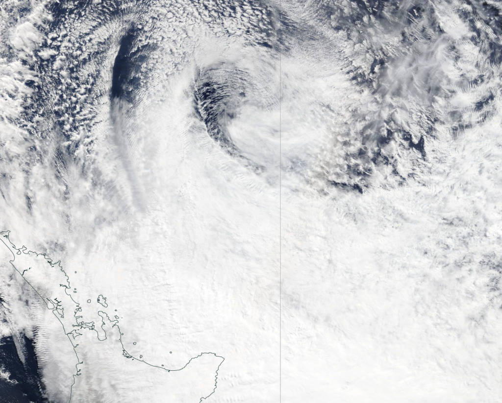
Early on March 17, the Moderate Resolution Imaging Spectroradiometer or MODIS instrument aboard Terra provided a visible image of ex-Tropical Cyclone Gretel that showed the center devoid of thunderstorms and precipitation. In the MODIS image, the layers of clouds around the low-level center appear like a wall of threaded clouds. The largest area of clouds associated with the system were in the southern quadrant and extended over northern New Zealand.

Gretel is expected to move southeast over waters to the north and east of New Zealand over the next few days, while remaining a deep extra-tropical low-pressure area.

Tropical cyclones/hurricanes are the most powerful weather events on Earth. NASA’s expertise in space and scientific exploration contributes to essential services provided to the American people by other federal agencies, such as hurricane weather forecasting.

For updated forecasts from NZMS, visit: www.metservice.com/

By Rob Gutro 
NASA’s Goddard Space Flight Center

Gretel – Southern Pacific Ocean

Mar. 16, 2020 – NASA Finds Gretel Becoming Extra-Tropical

NASA’s Terra satellite passed over the Southern Pacific Ocean and captured an image of Tropical Storm Gretel as it was transitioning into an extra-tropical cyclone, northwest of New Zealand.

Terra image of Gretel
On March 16, the MODIS instrument that flies aboard NASA’s Terra satellite took this image of Tropical Cyclone Gretel and showed a transitioning storm northwest of New Zealand. Credit: NASA Worldview

Tropical Cyclone 23P formed on March 14 at 4 p.m. EDT (2100 UTC) between Australia and New Caledonia. Once it intensified into a tropical storm, it was renamed Gretel.

On March 16, the Moderate Resolution Imaging Spectroradiometer or MODIS instrument that flies aboard NASA’s Terra satellite provided forecasters with a visible image of Tropical Cyclone Gretel. The bulk of Gretel’s clouds and storms were south and southeast of the center of circulation. Clouds associated with Gretel extended to northern New Zealand, despite the storm’s center being hundreds of miles away.

At 11 p.m. EDT on March 15 (0300 UTC on March 16), the Joint Typhoon Warning Center or JTWC issued the final warning on Gretel. At that time, the center of Tropical Cyclone Gretel was located near latitude 26.6 degrees south and longitude 169.7 degrees east, about 675 nautical miles north-northwest of Auckland, New Zealand. Maximum sustained winds were near 50 knots (58 mph/93 kph) and Gretel was speeding southeast at 25 knots (29 mph/46 kph).

The Joint Typhoon Warning Center or JTWC noted that Gretel will continue to move southeast and is now becoming extra-tropical.

Often, a tropical cyclone will transform into an extra-tropical cyclone as it recurves toward the poles (north or south, depending on the hemisphere the storm is located in). An extra-tropical cyclone is a storm system that primarily gets its energy from the horizontal temperature contrasts that exist in the atmosphere.

Tropical cyclones have their strongest winds near the earth’s surface, while extra-tropical cyclones have their strongest winds near the tropopause – about 8 miles (12 km) up. Tropical cyclones, in contrast, typically have little to no temperature differences across the storm at the surface and their winds are derived from the release of energy due to cloud/rain formation from the warm moist air of the tropics.

Tropical cyclones/hurricanes are the most powerful weather events on Earth. NASA’s expertise in space and scientific exploration contributes to essential services provided to the American people by other federal agencies, such as hurricane weather forecasting.

By Rob Gutro
NASA’s Goddard Space Flight Center