Juliette – Eastern Pacific Ocean

Sep. 06, 2019 – NASA Finds a Weaker Hurricane Juliette

Hurricane Juliette has been weakening and NASA-NOAA’s Suomi NPP satellite provided a look at the strength of storms within.

Suomi NPP image of Juliette
NASA-NOAA’s Suomi NPP satellite passed over Hurricane Juliette in the eastern Pacific Ocean and the VIIRS instrument aboard captured an image of the storm on Sept. 6 at 4:42 p.m. EDT (20:42 UTC). Coldest (red) cloud top temperatures were as cold as minus 70 degrees Fahrenheit (minus 56.6 Celsius). Credit: NASA/NOAA/NRL

At 5:00 a.m. EDT (11:00 PM HST) on Sept. 6, the National Hurricane Center (NHC) projected that Hurricane Juliette would decline to a tropical storm sometime on Friday and NASA had satellites hovering overhead revealed the hurricane’s slow decline.

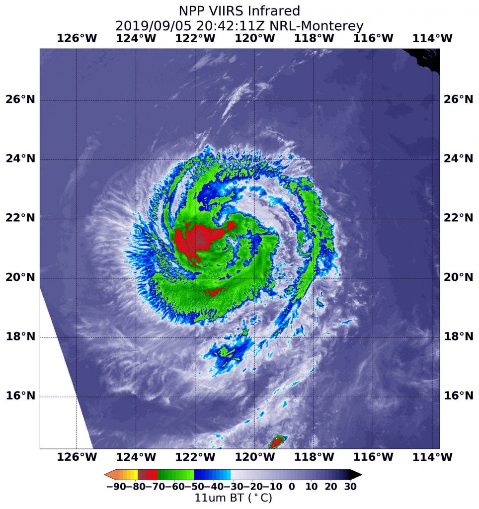
The NOAA-NASA Suomi NPP satellite passed over the decaying storm on Sept. 5 at 4:42 p.m. EDT (20:42 UTC) and observed the storm using the Visible Infrared Imaging Radiometer Suite (VIIRS) instrument. VIIRS showed the strongest storms were located in the western quadrant of Juliette. The National Hurricane Center noted 18 minutes later, “Deep convection associated with Juliette has decreased in coverage over the past 24 hours, however, the remaining convection still wraps completely around the center.”

Infrared imagery reveals cloud top temperatures, and the higher the cloud top, the colder it is, and the stronger the storm. Coldest cloud top temperatures were as cold as minus 70 degrees Fahrenheit (minus 56.6 Celsius) and found west of the center of circulation. Storms with cloud tops that cold have been found to generate heavy rainfall. Probably due to the fact that Juliette is decaying, the eye is not well-defined in this image and the strongest storms are no longer ringing the eye.

The NHC reported that at 5 a.m. EDT “(0900 UTC), the center of Hurricane Juliette was located near latitude 22.4 degrees north and longitude 122.7 degrees west which is about 815 miles (1,315 km) west of the southern tip of Baja, California. The maximum sustained winds are 80 mph (130 kph). Juliette is moving toward the northwest near 10 mph (17 kph). A motion toward the west-northwest should begin later tonight or Friday. A turn toward the west is forecast on Saturday and a general westward motion should continue through the weekend. The estimated minimum central pressure is 984 millibars.”

NHC predicts that additional weakening during the next few days, and Juliette is expected to become a tropical storm by Friday night, and degenerate into a remnant low pressure area on Sunday.

For more information on the storm visit: https://www.nhc.noaa.gov

By Lynn Jenner/Rob Gutro
NASA Goddard Space Flight Center

Juliette – Eastern Pacific Ocean

Sep. 05, 2019 – Satellite Finds a “Hook” of Heavy Rainfall in Hurricane Juliette

From its vantage point in orbit around the Earth, when the Global Precipitation Measurement mission or GPM core satellite passed over the Eastern Pacific Ocean, it gathered data on rainfall rates occurring in Hurricane Juliette. The areas of strongest rainfall resembled a hook.

GPM image of Juliette
The GPM core satellite passed over Juliette on Sept. 5 at 8:46 a.m. EDT (1246 UTC). GPM found the heaviest rainfall (purple) in the northwest of thunderstorms circling the center where it was falling at a rate of over 36 mm (about 1.4 inch) per hour. Heavy rainfall of about 25 mm (1 inch per hour) (in yellow and orange) stretched east and south in that same band circling the eye of the storm, giving the appearance of a hook around the storm’s eye. Credit: NASA/JAXA/NRL

The GPM satellite passed over Juliette on Sept. 5 at 8:46 a.m. EDT (1246 UTC). GPM found the heaviest rainfall in the northwest of thunderstorms circling the center where it was falling at a rate of over 36 mm (about 1.4 inch) per hour. Heavy rainfall of about 25 mm (1 inch per hour) stretched east and south in that same thunderstorm band circling the eye of the storm, giving the appearance of a hook around the storm’s eye. GPM is a joint mission between NASA and the Japan Aerospace Exploration Agency, JAXA.

At 5 a.m. EDT (2 a.m. PDT) on Sept. 5, the National Hurricane Center (NHC) noted, “Juliette’s cloud pattern has changed little during the past several hours.  If anything, the spiral bands appear to have improved a bit in the western portion of the cyclone.” At that time, the center of Hurricane Juliette was located near latitude 20.2 degrees north and longitude 119.1 degrees west. That’s about 620 miles (995 km) west-southwest of the southern tip of Baja California, Mexico.

Juliette is moving toward the northwest near 9 mph (15 kph). The hurricane is expected to move to the west-northwest at a slightly faster forward speed on Friday and should continue this motion through Saturday. Maximum sustained winds remain near 90 mph (150 kph) with higher gusts. The estimated minimum central pressure is 976 millibars.

Gradual weakening is forecast to resume today [Sept. 5] as the storm is expected to move over cooler sea surface temperature and encounter dry air and outside winds (vertical wind shear). Further weakening is expected during the next several days.  Juliette should weaken to a tropical storm on Friday.

For updated forecasts, visit: www.nhc.noaa.gov

By Rob Gutro
NASA’s Goddard Space Flight Center

Juliette – Eastern Pacific Ocean

Sep. 04, 2019 – NASA Catches Hurricane Juliette Over Mexico’s Socorro Island

Although Hurricane Juliette is no longer a major hurricane in the Eastern Pacific Ocean, NASA’s Aqua satellite revealed there are still powerful thunderstorms around its center and captured an image of the storm over Socorro Island, Mexico.

AIRS image of Juliette
On Sept. 3, at 5:05 p.m. EDT (2105 UTC) the AIRS instrument aboard NASA’s Aqua satellite analyzed cloud top temperatures of Hurricane Juliette in infrared light. AIRS found coldest cloud top temperatures (purple) of strongest thunderstorms were as cold as or colder than minus 63 degrees Fahrenheit (minus 53 degrees Celsius) around the center and in fragmented bands of thunderstorms stretching from the north to the southeast. Socorro Island, Mexico is visible as a small black dot in the storm’s eastern quadrant (right). Credit: NASA JPL/Heidar Thrastarson

Aqua provided forecasters at the National Hurricane Center with infrared data and cloud top temperature information that indicate Juliette’s rainmaking capabilities that affected Socorro Island.

Cloud top temperatures provide information to forecasters about where the strongest storms are located within a tropical cyclone. The stronger the storms, the higher they extend into the troposphere with colder cloud temperatures.

NASA’s Aqua satellite analyzed the storm on Sept. 3, at 5:05 p.m. EDT (2105 UTC) using the Atmospheric Infrared Sounder or AIRS instrument. AIRS found coldest cloud top temperatures as cold as or colder than minus 63 degrees Fahrenheit (minus 53 degrees Celsius) around the center and in fragmented bands of thunderstorms stretching from the north to the southeast. NASA research has shown that cloud top temperatures that cold indicate strong storms that have the capability to create heavy rain. That heavy rainfall was experienced by the small number of residents on Socorro Island.

Socorro Island is a small volcanic island in the Revillagigedo Islands. It is about 373 miles (600 km) west of Mexico’s west coast. The island is only 51 square miles or 132 square kilometers. It is the largest of the four islands of the Revillagigedo Archipelago.

On Sept. 3, NOAA’s National Hurricane Center’s (NHC) noted at 5 a.m. EDT (0900 UTC), the center of Hurricane Juliette was located near latitude 19.1 degrees north and, longitude 116.4 degrees west. The center is about 495 miles (795 km) west-southwest of the southern tip of Baja California, Mexico. Juliette is moving toward the west-northwest near 6 mph (9 kph), and this general motion is expected during the next few days. Maximum sustained winds are near 110 mph (175 kph) with higher gusts. The estimated minimum central pressure is 966 millibars.

NHC said that additional slow weakening is forecast during the next several days.

For updated forecasts, visit: www.nhc.noaa.gov

For updated warnings from the Mexican Meteorological Service, visit: https://smn.conagua.gob.mx/es/pronosticos/avisos/aviso-de-ciclon-tropical-en-el-oceano-pacifico

By Rob Gutro
NASA’s Goddard Space Flight Center  

Juliette – Eastern Pacific Ocean

Sep. 03, 2019 – Major Hurricane Juliette’s Emerging Eye Spotted in NASA Satellite Imagery

NASA’s Aqua satellite passed over the Eastern Pacific Ocean and provided an image of Hurricane Juliette as its eye began to emerge. Juliette has grown into a major hurricane, about 450 miles southwest of the southern tip of Baja California, Mexico.

Aqua image of Juliette
On Sept. 2, 2019 at 4:25 p.m. EDT (2025 UTC) the MODIS instrument aboard NASA’s Aqua satellite provided a visible image of Hurricane Juliette in the Eastern Pacific Ocean as its eye began to show. Credit: NASA/NRL

Juliette developed on Sunday, Sept 1 around 5 a.m. EDT (0900 UTC) as a tropical storm. By 5 p.m. EDT on Sept. 2, the storm had strengthened into a hurricane.

On Sept. 2, 2019 at 4:25 p.m. EDT (2025 UTC) the Moderate Resolution Imaging Spectroradiometer or MODIS instrument aboard NASA’s Aqua satellite provided a visible image of Hurricane Juliette that revealed its emerging eye around a thick tight circle of powerful thunderstorms. Hurricane-force winds extend outward up to 35 miles (55 km) from the center and tropical-storm-force winds extend outward up to 125 miles (205 km).

NASA researches hurricanes to better understand their behavior, and provides data to forecasters at NOAA’s NHC or National Hurricane Center to assist in their forecasting.

On Sept. 3 at 11 a.m. EDT (1500 UTC), NOAA’s National Hurricane Center said the eye of Hurricane Juliette was located near latitude 18.4 degrees north and longitude 115.0 degrees west. That’s about 455 miles (730 km) southwest of the southern tip of Baja California, Mexico. Juliette is moving toward the northwest near 8 mph (13 kph), and a northwest to west-northwest motion is expected through Friday. Maximum sustained winds have increased to near 125 mph (205 kph) with higher gusts.  Juliette is a category 3 hurricane on the Saffir-Simpson Hurricane Wind Scale. The estimated minimum central pressure is 953 millibars based on satellite estimates and data from the Mexican Navy station on Clarion Island.

NHC said. “Some strengthening is possible today, with weakening forecast to begin by late Wednesday and continuing through Friday.”

For updated forecasts, visit NOAA’s NHC: www.nhc.noaa.gov

By Rob Gutro
NASA’s Goddard Space Flight Center