Aug. 12, 2019 – NASA Finds Deadly Lekima’s Remnants Over China
NASA’s Terra satellite passed over the Northwestern Pacific Ocean and captured a visible picture of the remnant clouds of deadly former Typhoon Lekima over eastern China.
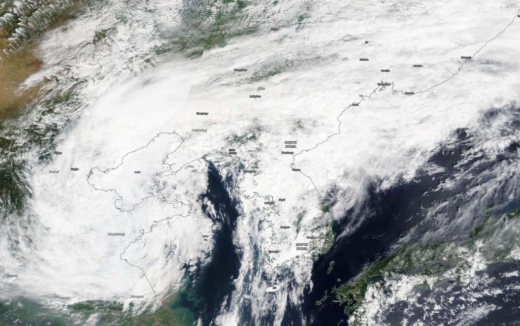
On Aug. 12, 2019, the MODIS instrument aboard NASA’s Terra satellite provided a visible image of former Typhoon Lekima in the Northwestern Pacific Ocean. Credit: NASA Worldview, Earth Observing System Data and Information System (EOSDIS)
On Aug. 12, 2019, the Moderate Resolution Imaging Spectroradiometer or MODIS instrument aboard NASA’s Terra satellite provided a visible image of Lekima’s remnant clouds. The remnants blanketed eastern China and the Korean Peninsula, also extending over part of the Yellow Sea.
Typhoon Lekima made landfall early on Aug. 10 in the Zhejiang province. At landfall, Lekima’s winds were gusting up to 185 kph (115 mph). Typhoon Lekima made another landfall in coastal regions of Huangdao district, Qingdao, Shandong around 8:50 p.m. local time on August 11. Lekima caused billions of dollars in damage, triggered travel delays and caused fatalities. Reuters reported that 44 people perished from Typhoon Lekima’s landfall in China.
On Aug. 12, China’s National Meteorological Center (NMC) released a blue warning for a typhoon at 6:00 a.m. local time. NMC noted, “Lekima [will] dwell in neighboring regions of northern Shandong Peninsula and move north by east direction with a dwindling intensity.”
The NMC forecast from August 12 to 13 noted that the areas including northern Shandong, northeastern Henan, eastern Tianjin, central-southern Liaoning, and eastern Jilin will be exposed to moderate and heavy rain. NMC’s forecast noted, “Heavy downpours (100-200 mm/3.9 to 7.8 inches) will pummel northeastern Hebei, and southwestern Liaoning.”
Aug. 09, 2019 – NASA Gives Typhoon Lekima a Twice-Over with the Aqua Satellite
NASA’s Aqua satellite provided infrared and visible views of Typhoon Lekima as it was approaching landfall in China. China has posted Typhoon and Heavy Rain Warnings for Lekima.
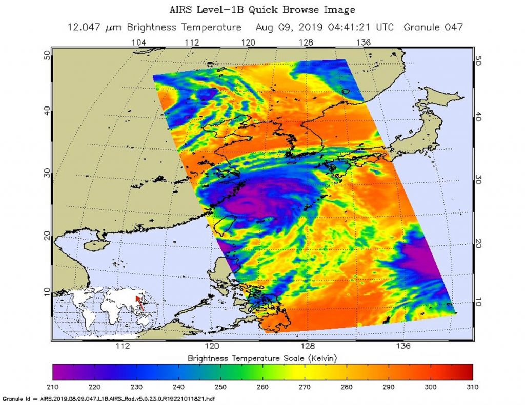
On Aug. 9 at 12:41 a.m. EDT (441 UTC) the AIRS instrument aboard NASA’s Aqua satellite analyzed Lekima’s cloud top temperatures in infrared light. AIRS found coldest cloud top temperatures (purple) of strongest thunderstorms were as cold as or colder than minus 63 degrees Fahrenheit (minus 53 degrees Celsius) in the thick band of thunderstorms around the eye and in bands north and southeast of the center. Credit: NASA JPL/Heidar Thrastarson
On Aug. 9 at 12:41 a.m. EDT (441 UTC) the Atmospheric Infrared Sounder or AIRS instrument aboard NASA’s Aqua satellite analyzed Lekima’s cloud top temperatures in infrared light. The stronger the storms, the higher they extend into the troposphere, and they have the colder cloud temperatures. AIRS found coldest cloud top temperatures as cold as or colder than minus 63 degrees Fahrenheit (minus 53 degrees Celsius) around the eye and in thick bands of thunderstorms wrapping into the center from the north and southeast. Storms with cloud tops that cold have been found to generate heavy rainfall.
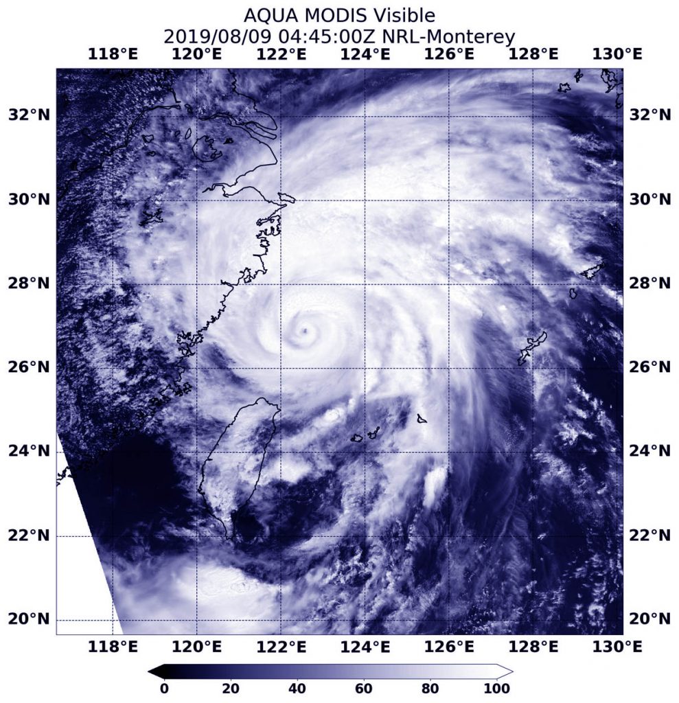
On Aug 9 at 12:45 a.m. EDT (0445 UTC), the Moderate Imaging Spectroradiometer or MODIS instrument that also flies aboard NASA’s Aqua satellite provided visible views of powerful Typhoon Lekima affecting China. The satellite showed a clear, small, rounded eye surrounded by a thick, powerful ring of thunderstorms and a large band of thunderstorms extending north of the center.
On Aug 9 at 12:45 a.m. EDT (0445 UTC), the MODIS instrument that flies aboard NASA’s Aqua revealed powerful Typhoon Lekima affecting China. The satellite showed a clear eye surrounded by a thick, powerful ring of thunderstorms and a large band of thunderstorms extending north of the center. Credit: NASA/NRL
At 11 a.m. EDT (1500 UTC) the center of Typhoon Lekima was located near latitude 27.8 degrees north latitude and longitude 121.8 degrees east. Lekima is moving toward the north-northeast. Maximum sustained winds are near 95 knots (109 mph/176 kph). Lekima is a Category 2 hurricane on the Saffir-Simpson Hurricane Wind Scale.
China’s National Meteorological Center (NMC) issued a Red Warning for the Typhoon at 10:00 a.m. local times on August 9 and an Orange Warning for rainstorm.
NMC said, “Typhoon Lekima is forecast to move northwest direction at the speed of 15-20 kph and moves towards coastal regions of Zhejiang and make landfall in coastal regions from Xiangshan to Cangnan of Zhejiang from the dawn to the daytime of August 10. From August 9 to 10, Bashi Channel, Taiwan Strait, coastal sea areas of Taiwan, East China Sea, Hangzhou Bay, Yangtze River Estuary, coastal regions of Zhejiang, Shanghai and southern Jiangsu, northern Taiwan Island, southern Huanghuai Sea, central-northern Fujian will be exposed to scale 7-9 gale.
Heavy rain to rainstorm will pummel Zhejiang, northern Fujian, eastern and southern Jiangsu, Shanghai, southeastern Anhui, and Taiwan Island. Heavy downpour will pound central-eastern Zhejiang, southern Shanghai, and Taiwan Island. Torrential downpour (250-320mm) will slam eastern Zhejiang and central Taiwan Island. (Aug. 9).”
The Orange Warning says, “It is predicted that from August 9 to 10, heavy rain to rainstorm will grip Zhejiang, northern Fujian, eastern and southern Jiangsu, Shanghai, southeastern Anhui, Taiwan Island, Beijing, central-southern Hebei, central Henan, southwestern and northern Chongqing, southern Sichuan, central-northern Yunnan, and eastern Heilongjiang. Heavy downpour will pound central-eastern Zhejiang, southern Shanghai, and Taiwan Island. Torrential downpour (250-320mm) will slam eastern Zhejiang and central Taiwan Island.”
Aug. 08, 2019 – Lekima Becomes Supertyphoon, Heading Towards Eastern China
NASA’s Aqua satellite captured this infrared image of Supertyphoon Lekima as it tracked 214 nautical miles southwest of Okinawa, Japan. Tropical cyclone warning signal #1 is in force for the Luzon provinces of Batanes and Babuyan group of islands. The storm has tracked north-northwest at 10 knots over the past six hours.
NASA’s Aqua satellite was able to capture this infrared image of Supertyphoon Lekima on August 07, 2019 at 1:53pm (0453 UTC) with the AIRS instrument onboard. The dark purple shows the coldest cloud tops within the storm. Cloud top temperatures that cold indicate strong storms that have the capability to create heavy rain. Credit: NASA JPL/Heidar Thrastarson
Satellite imagery shows this system continues to rapidly intensify as evidenced by tightly compact central convection which includes an eight nautical mile-sized eye with a tight pinhole in the eye which is an indication of a strong storm.
The supertyphoon is currently producing winds in excess of 130 knots (149 mph). On the Saffir-Simpson hurricane scale that would be a Category 4 hurricane. With the low vertical wind shear this storm seems well defined and coupled with warm sea surface temperatures of 30 degrees C (86 degrees F) the conditions will most likely allow the storm to continue to intensify.
Supertyphoon Lekima is expected to reach the east coast of China near Taizhou within 48 hours and is expected to sustain the current intensity due to favorable conditions. Interaction with land, however, will begin to weaken the storm to 60 knots (69 mph) by 72 hours, shortly after it crosses over Shanghai. At that point the storm will turn north-northwest and rapidly weaken as it continues further inland.
Aug. 07, 2019 – Philippines on Alert with Typhoon Lekima
Lekima is now a typhoon and has triggered warnings in the Philippines. NASA’s Aqua satellite passed over the Northwestern Pacific Ocean and provided a visible image of the storm that shows a clear eye.
On Aug. 7, 2019 at 12:55 a.m. EDT (0455 UTC), the MODIS instrument aboard NASA’s Aqua satellite provided a visible image of Typhoon Lekima in the Northwestern Pacific Ocean. Credit: NASA/NRL
On Aug. 7, the Philippines’ PAGASA service issued Tropical cyclone warning signal #1 for the Luzon provinces of Batanes and Babuyan group of islands.
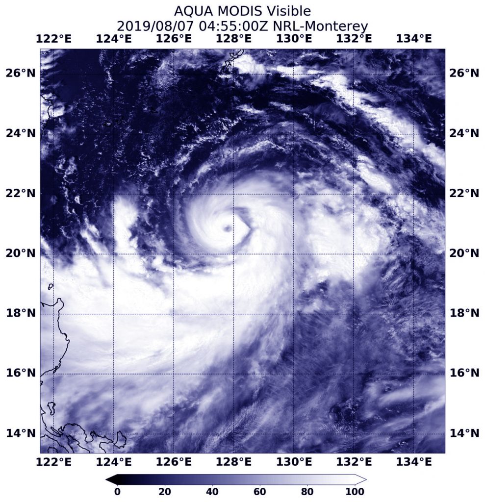
On Aug. 7, 2019 at 12:55 a.m. EDT (0455 UTC), the Moderate Resolution Imaging Spectroradiometer or MODIS instrument aboard NASA’s Aqua satellite provided a visible image of Lekima that revealed a clear eye surrounded by a tight, circular band of powerful thunderstorms. Lekima also has a large band of thunderstorms that are feeding into the center from the south and east.
At 5 a.m. EDT (0900 UTC), Typhoon Lekima had maximum sustained winds near 85 knots (98 MPH/157 KPH). It was centered near 20.9 degrees north latitude and 127.7 degrees east longitude. That is 421 nautical miles south of Kadena Air Base, Okinawa island, Japan. Lekima was moving to the northwest and generating 25-foot high waves.
The Joint Typhoon Warning Center expects Lekima to continue moving northwest and strengthen to 125 knots (144 mph/232 kph), making it a Category 4 hurricane on the Saffir-Simpson hurricane wind scale. Lekima is expected to pass just north of northern Taiwan around August 9 and make landfall near Shanghai around August 12.
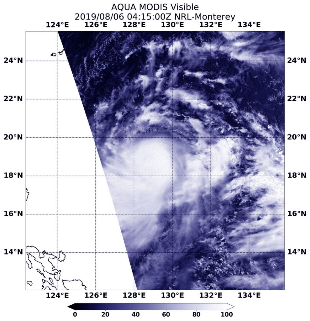
Aug. 06, 2019 – NASA Satellite Finds Strong Storms Circling Lekima’s Center
NASA’s Aqua satellite passed over the Northwestern Pacific Ocean and captured a visible image of strengthening Tropical Storm Lekima.
On Aug. 6, 2019, the MODIS instrument aboard NASA’s Aqua satellite provided a visible image of Tropical Storm Lekima in the Northwestern Pacific Ocean. Credit: NASA/NRL
On Aug. 6, the Moderate Resolution Imaging Spectroradiometer or MODIS instrument aboard NASA’s Aqua satellite provided a visible image of Lekima that showed a ring of strong thunderstorms around its center of circulation.
At 5 a.m. EDT (0900 UTC), the center of Lekima was located near latitude 19.1 degrees north and longitude 129.0 degrees east. Lekima was about 449 nautical miles south of Kadena Air Base, Okinawa, Japan. Lekima was moving to the north-northwest and had maximum sustained winds near 50 knots (57 mph/92 kph).
The Joint Typhoon Warning Center expects Lekima to move northwest and strengthen into a typhoon. After 3 days, it will pass over Taiwan and turn northeast just off the east coast of China, where it is expected to dissipate.
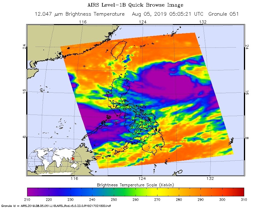
Aug. 05, 2019 – NASA Gazes into Tropical Storm Lekima in Philippine Sea
NASA’s Aqua satellite gazed into Tropical Storm Lekima as it moved through the Philippine Sea on August 5 and the AIRS instrument aboard took the temperature of its cloud tops to estimate storm strength.
On Aug. 5, at 0105 a.m. EDT (0505 UTC) the AIRS instrument aboard NASA’s Aqua satellite analyzed cloud top temperatures of Tropical Storm Lekima in infrared light. AIRS found coldest cloud top temperatures (purple) of strongest thunderstorms were as cold as or colder than minus 63 degrees Fahrenheit (minus 53 degrees Celsius). Credit: NASA JPL/Heidar Thrastarson
Lekima formed early on Aug. 4 as Tropical Depression 10W and strengthened into a tropical storm on Aug. 5, when it was renamed Lekima.
NASA’s Aqua satellite passed over Lekima on Aug. 5, at 0105 a.m. EDT (0505 UTC). The Atmospheric Infrared Sounder or AIRS instrument aboard NASA’s Aqua satellite analyzed Lekima in infrared light and found cloud top temperatures of strongest thunderstorms as cold as or colder than minus 63 degrees Fahrenheit (minus 53 degrees Celsius) were wrapping into the low-level center from the south. Cloud top temperatures that cold indicate strong storms that have the capability to create heavy rain.
Strongest storms extend high into the troposphere and have very cold cloud top temperatures as cold as or colder than minus 63 degrees Fahrenheit (minus 53 degrees Celsius).
At 5 a.m. EDT (0900 UTC), the center of Tropical Storm Lekima was located near latitude 19.2 degrees north and 129.5 degrees east longitude. Lekima’s center is about 456 nautical miles south-southeast of Kadena Air Base, Okinawa Island, Japan. It was moving to the northwest and had maximum sustained winds near 35 knots (40 mph/64 kph). In the Philippines, Lekima is called Hanna.
The Joint Typhoon Warning Center forecasts that Lekima will move northwest and make landfall over northern Taiwan on Aug. 9, then make a final landfall in mainland China.