Lorna (Southern Indian Ocean)

Apr. 29, 2019 – NASA Shows Winds Causing Tropical Cyclone Lorna’s Demise

NASA’s Aqua satellite saw Tropical Cyclone Lorna was being torn apart by strong northwesterly wind shear in the Southern Indian Ocean.

Aqua image of Lorna
On April 29 at 4:29 a.m. EDT (0829 UTC), the MODIS instrument aboard NASA’s Aqua satellite provided a visible image of Tropical Cyclone Lorna in the Southern Indian Ocean. Credit: NASA/NRL

In general, wind shear is a measure of how the speed and direction of winds change with altitude. Tropical cyclones are like rotating cylinders of winds. Each level needs to be stacked on top each other vertically in order for the storm to maintain strength or intensify. Wind shear occurs when winds at different levels of the atmosphere push against the rotating cylinder of winds, weakening the rotation by pushing it apart at different levels.

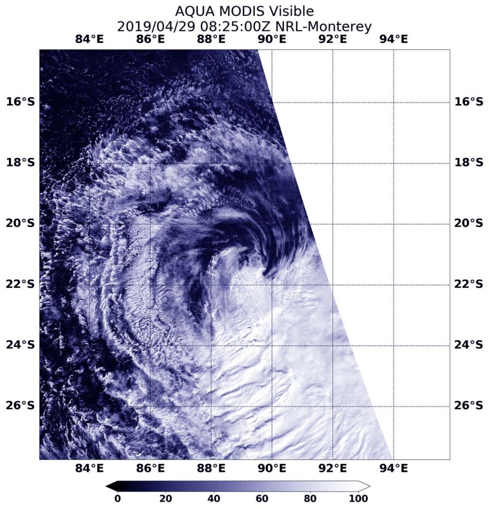
On April 29 at 4:29 a.m. EDT (0829 UTC), the Moderate Resolution Imaging Spectroradiometer or MODIS instrument aboard NASA’s Aqua satellite provided a visible image of Lorna. Northwesterly winds were pushing the bulk of Lorna’s clouds far southeast of its center.

At 11 a.m. EDT (1500 UTC), the Joint Typhoon Warning Center or JTWC issued their final warning in Lorna. At that time, JTWC noted that Tropical Cyclone Lorna was located near 22.1 degrees south latitude and 88.8 degrees east longitude. That is 738 nautical miles southwest of Cocos Island. Lorna was moving to the south-southwest. Maximum sustained winds dropped to 35 knots (40 mph/65 kph) and the storm was getting weaker.

Lorna is rapidly weakening under adverse atmospheric conditions. The JTWC noted that the “environment is very hostile with extremely high (50 to 60 knot/57 to 69 mph/ /92 to 111 kph) vertical wind shear,” which is tearing the storm apart. Lorna is forecast to dissipate by April 30.

By Rob Gutro
NASA’s Goddard Space Flight Center

Lorna (Southern Indian Ocean)

Apr. 26, 2019 – NASA’s Aqua Satellite Tracks Tropical Cyclone Lorna

As Tropical Storm Lorna continued moving in a southerly direction in the Southeastern Indian Ocean, NASA’s Aqua satellite passed overhead and provided forecasters with a look at the storm.

Aqua image of Lorna
At 3:55 a.m. EDT (0755 UTC) on April 26, the MODIS instrument aboard Aqua captured a visible image of Tropical Storm Lorna in the Southeastern Indian Ocean. Credit: NASA/NRL

At 3:55 a.m. EDT (0755 UTC) on April 26, the Moderate Resolution Imaging Spectroradiometer or MODIS instrument aboard Aqua captured a visible image of Lorna. Lorna does not appear symmetrical and the strongest thunderstorms appear over the western side of the storm. The Joint Typhoon Warning Center or JTWC forecasters also noted, “Animated enhanced infrared satellite imagery depicts a central dense overcast feature obscuring the low-level circulation center.”

By 11 a.m. EDT (1500 UTC) on April 26, Tropical Storm Lorna had maximum sustained winds near 60 knots (46 mph/74 kph). Lorna was centered near 13.0 degrees south latitude and 88.6 degrees east longitude, approximately 495 nautical miles west of Cocos Island. Lorna was moving to the east-southeast.

Lorna is forecast to strengthen to hurricane-strengthen and move in a southerly direction. Over the weekend of April 27 and 28, Lorna is expected to begin transitioning into an extra-tropical cyclone.

That means that a tropical cyclone has lost its “tropical” characteristics. The National Hurricane Center defines “extra-tropical” as a transition that implies both poleward displacement (meaning it moves toward the north or south pole) of the cyclone and the conversion of the cyclone’s primary energy source from the release of latent heat of condensation to baroclinic (the temperature contrast between warm and cold air masses) processes. It is important to note that cyclones can become extratropical and retain winds of hurricane or tropical storm force.

By Rob Gutro
NASA’s Goddard Space Flight Center

Lorna (Southern Indian Ocean)

Apr. 25, 2019 – NASA Finds a More Circular Tropical Cyclone Lorna

NASA-NOAA’s Suomi NPP satellite passed over the Southern Indian Ocean and captured a visible image of what appeared to be a more organized Tropical Cyclone Lorna.

Aqua image of Lorna
NASA-NOAA’s Suomi NPP satellite passed over the Southern Indian Ocean and captured a visible image of Tropical Cyclone Lorna, on April 25 at 4:30 a.m. EDT (0830 UTC). Credit: NASA/NOAA/NRL

The Suomi NPP satellite flew over Lorna on April 25 at 4:30 a.m. EDT (0830 UTC) and the Visible Infrared Imaging Radiometer Suite (VIIRS) instrument provided a visible image of the storm. The VIIRS image showed a more circular storm, indicating that the storm was consolidating and strengthening. Microwave data revealed an eye feature.

At 11 a.m. EDT (1500 UTC) on April 25, Tropical Cyclone Lorna was centered near 10.8 degrees south latitude and 85.9 degrees east longitude, about 824 miles east-southeast of Diego Garcia. Lorna was moving to the east-southeast and had maximum sustained winds 50 knots (57 mph/92 kph).

Lorna is no threat to land areas. Lorna is expected to move southeast while strengthening to 75 knots (86 mph/139 kph) attaining hurricane strength. After three days, the storm will turn south and become extra-tropical.

By Rob Gutro 
NASA’s Goddard Space Flight Center

Lorna (Southeastern Indian Ocean)

Apr. 24, 2019 – NASA’s Aqua Satellite Catches Tropical Cyclone Lorna Organizing

Visible satellite imagery from NASA’s Aqua satellite revealed the recently formed Tropical Storm Lorna was getting organized in the Southeastern Indian Ocean.

Aqua image of Lorna
At 4:15 a.m. EDT (0815 UTC) on April 24, the MODIS instrument aboard Aqua captured a visible image of newly formed Tropical Storm Lorna in the Southeastern Indian Ocean. Credit: NASA/NRL

Lorna developed into a tropical storm on April 23 at 11 a.m. EDT (1500 UTC) and was named Tropical Cyclone 25S. On April 24, it received the name Lorna. At 4:15 a.m. EDT (0815 UTC) on April 24, the Moderate Resolution Imaging Spectroradiometer or MODIS instrument aboard Aqua captured a visible image of Lorna. The Joint Typhoon Warning Center or JTWC forecasters noted “persistent deep convection to the west of, and obscuring, the low level circulation center.”

By 11 a.m. EDT (1500 UTC) on April 24, Tropical Storm Lorna had maximum sustained winds near 40 knots (46 mph/74 kph). Lorna was centered near 10.9 degrees south latitude and 84.6 degrees east longitude, approximately 743 nautical miles southeast of Diego Garcia. Lorna has tracked to the east-southeast.

The tropical low pressure area designated System 92S is located east of Tropical Cyclone Lorna. The JTWC forecaster expect 92S to interact Lorna may merge with it.

Lorna is forecast to strengthen to hurricane-strengthen and move in a southerly direction. Lorna is not expected to affect any land areas.

By Rob Gutro
NASA’s Goddard Space Flight Center