Lowell – Eastern Pacific Ocean

Sep. 25, 2020 – NASA Finds Wind Shear Displacing Lowell’s Strongest Storms

NASA’s Aqua satellite provided an infrared view of Tropical Storm Lowell that revealed the effects of outside winds battering the storm.

Wind shear occurs when winds at different levels of the atmosphere push against the rotating cylinder of winds, weakening the rotation by pushing it apart at different levels.

Aqua image of Lowell
On Sept. 25 at 5:45 a.m. EDT (0945 UTC), the MODIS instrument that flies aboard NASA’s Aqua satellite gathered infrared data on Lowell that confirmed wind shear was adversely affecting the storm. Persistent westerly vertical wind shear showed strongest storms (yellow) pushed east of the center where cloud top temperatures were as cold as minus 50 degrees Fahrenheit (minus 45.5 Celsius). Credit: NASA/NRL

NASA’s Aqua Satellite Reveals Effects of Wind Shear 

Infrared light is a tool used to analyze the strength of storms in tropical cyclones by providing temperature information about a system’s clouds. The strongest thunderstorms that reach highest into the atmosphere have the coldest cloud top temperatures. This temperature information can also tell forecasters if the strongest storms in a tropical cyclone are pushed away from the center, indicating wind shear.

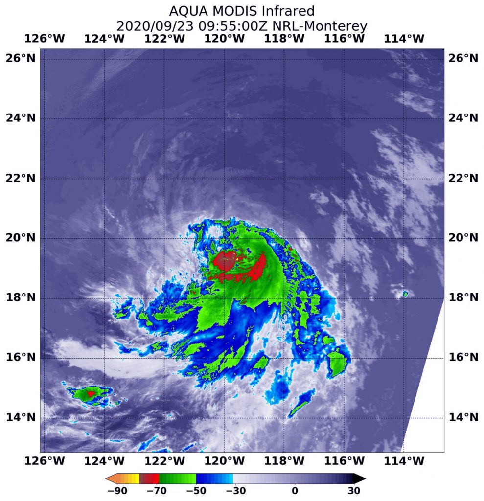
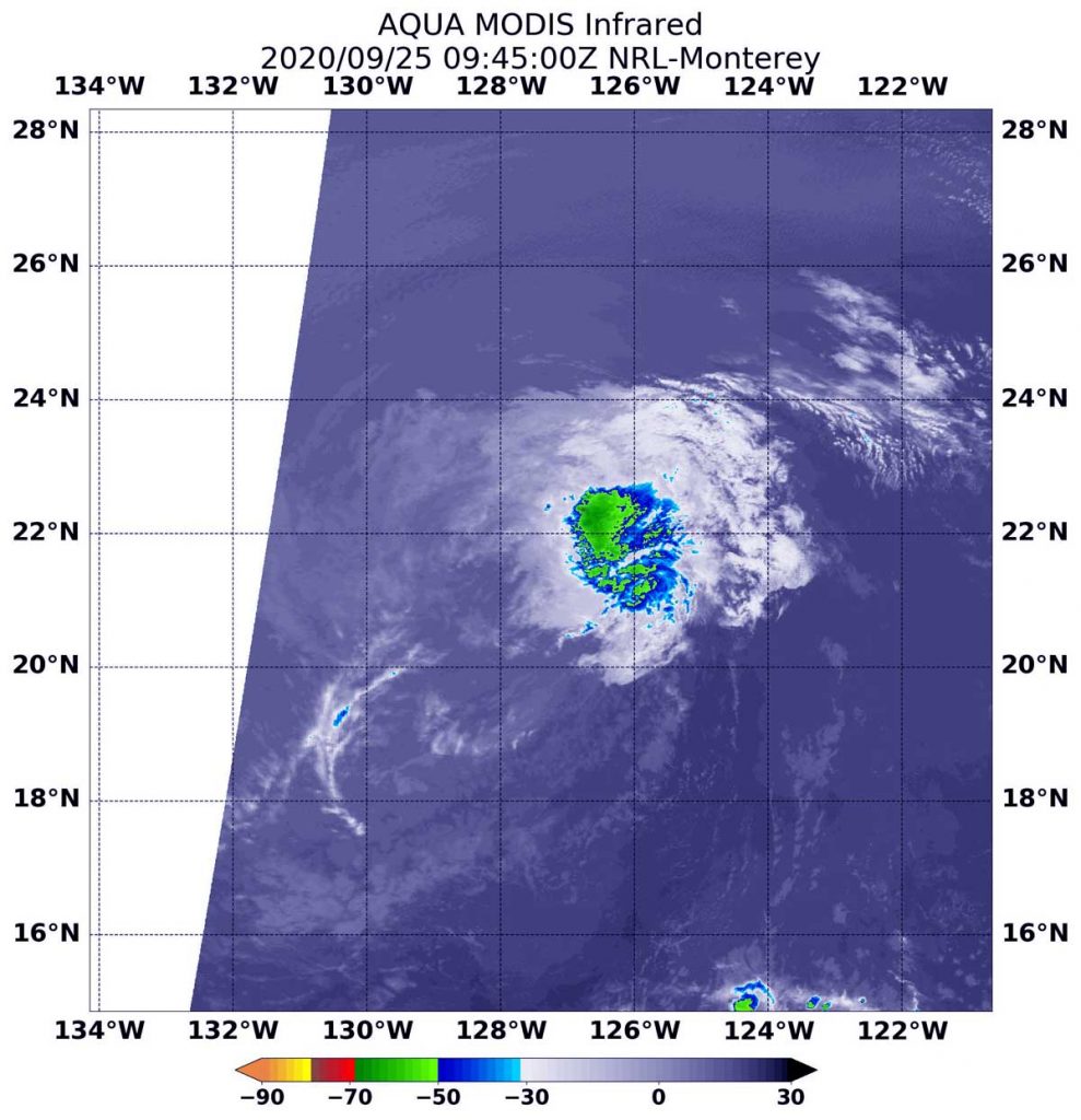
On Sept. 25 at 5:45 a.m. EDT (0945 UTC), the Moderate Resolution Imaging Spectroradiometer or MODIS instrument that flies aboard NASA’s Aqua satellite gathered infrared data on Lowell that confirmed wind shear was adversely affecting the storm. Westerly vertical wind shear pushed strongest storms east of the center where cloud top temperatures are as cold as minus 50 degrees Fahrenheit (minus 45.5 Celsius). That small area of strongest storms was located 100 nautical miles east of Lowell’s center.

NOAA’s National Hurricane Center noted in their discussion today, “The areal coverage of Lowell’s convection and its distance from the center already put it on the margins of what is considered organized deep convection.”

Status of Tropical Storm Lowell  

At 5 a.m. EDT (0900 UTC), the center of Tropical Storm Lowell was located near latitude 21.6 degrees north and longitude 128.0 degrees west. That is about 1,160 miles (1,865 km) west of the southern tip of Baja California, Mexico. Lowell was moving toward the west near 12 mph (19 kph), and this general motion, with some increase in forward speed, is expected to continue into early next week.

Maximum sustained winds are near 40 mph (65 kph) with higher gusts. Gradual weakening is forecast, and Lowell is expected to become a remnant low today, Sept. 25.

Forecast for Lowell

“Cold waters and increasing west-to-southwesterly wind shear expected over the next 24 hours should finally do the convection in,” noted Robbie Berg, a hurricane specialist at NOAA’s National Hurricane Center in Miami, Fla. That should cause Lowell to lose tropical cyclone status on Friday. “Even stronger [wind] shear is forecast to cause the remnant low to gradually weaken through the end of the 5-day forecast period.”

NASA Researches Tropical Cyclones

Hurricanes/tropical cyclones are the most powerful weather events on Earth. NASA’s expertise in space and scientific exploration contributes to essential services provided to the American people by other federal agencies, such as hurricane weather forecasting.

For more than five decades, NASA has used the vantage point of space to understand and explore our home planet, improve lives and safeguard our future. NASA brings together technology, science, and unique global Earth observations to provide societal benefits and strengthen our nation. Advancing knowledge of our home planet contributes directly to America’s leadership in space and scientific exploration.

For updated forecasts. visit: www.nhc.noaa.gov

By Rob Gutro
NASA’s Goddard Space Flight Center

Lowell – Eastern Pacific Ocean

Sep. 23, 2020 – NASA-NOAA Satellite Finds Wind Shear Affecting Tropical Storm Lowell

NASA-NOAA’s Suomi NPP satellite passed over the Eastern North Pacific Ocean and captured a visible image of Tropical Storm Lowell that revealed the storm was dealing with wind shear.

Suomi NPP image of Lowell
NASA-NOAA’s Suomi NPP satellite captured a visible image of Tropical Storm Lowell on Sept. 23 as it continued moving west through the open waters of the Eastern North Pacific Ocean. Credit: NASA Worldview, Earth Observing System Data and Information System (EOSDIS)

Wind shear is caused by winds outside of a tropical cyclone that are blowing against it at different altitudes and directions. Wind shear weakens tropical cyclones by adversely affecting their circulation. Wind shear can elongate a storm and make it spin more slowly, leading to weakening.

The Visible Infrared Imaging Radiometer Suite (VIIRS) instrument aboard Suomi NPP provided a visible image of Lowell on Sept. 23. Around the time of the Suomi NPP image, the National Hurricane Center noted a band of deep convection and thunderstorms had continued over the eastern quadrant of the storm, but the center was exposed and was located west of that band of thunderstorms. Lowell was being affected by moderate northwesterly wind shear which is not expected to abate much.

By 5 p.m. EDT on Sept. 23, Lowell was maintaining strength with a few bands of deep convection and developing thunderstorms located 30 nautical miles or more to the east of the exposed center.

Lowell’s Status on Sept. 24

At 5 a.m. EDT (0900 UTC) on Sept.24, the center of Tropical Storm Lowell was located near latitude 21.2 degrees north and longitude 123.7 degrees west. That is about 890 miles (1,435 km) west of the southern tip of Baja California, Mexico.

Lowell was moving toward the west-northwest near 10 mph (17 kph). Maximum sustained winds are near 45 mph (75 kph) with higher gusts. Gradual weakening is forecast to begin by late Thursday.

Lowell’s Forecast

NHC said a turn toward the west is expected Thursday morning, with that heading and a gradual increase in forward speed continuing through early next week. Lowell is expected to weaken to a tropical depression by late Friday and become a remnant low by early Saturday.

NASA Researches Tropical Cyclones

Hurricanes/tropical cyclones are the most powerful weather events on Earth. NASA’s expertise in space and scientific exploration contributes to essential services provided to the American people by other federal agencies, such as hurricane weather forecasting.

For more than five decades, NASA has used the vantage point of space to understand and explore our home planet, improve lives and safeguard our future. NASA brings together technology, science, and unique global Earth observations to provide societal benefits and strengthen our nation. Advancing knowledge of our home planet contributes directly to America’s leadership in space and scientific exploration.

By Rob Gutro 
NASA’s Goddard Space Flight Center

Lowell – Eastern Pacific Ocean

Sep. 23, 2020 – NASA Finds Tropical Storm Lowell’s Center North of Strongest Side

NASA’s Aqua satellite used infrared light to identify strongest storms and coldest cloud top temperatures in Tropical Storm Lowell and found them south of the center of circulation.

Lowell is moving through the Eastern Pacific Ocean and far from land areas. There are no coastal watches or warnings in effect.

AIRS image of Lowell
On Sept. 23 at 5:55 a.m. EDT (0955 UTC), the MODIS instrument aboard NASA’s Aqua satellite gathered temperature information about Tropical Storm Lowell’s cloud tops. MODIS found the most powerful thunderstorms (red) were east and south of the center, where temperatures were as cold as or colder than minus 70 degrees Fahrenheit (minus 56.6 Celsius). Credit: NASA/NRL

Infrared Data Reveals Powerful Storms

On Sept. 23 at 5:55 a.m. EDT (0955 UTC), the Moderate Resolution Imaging Spectroradiometer or MODIS instrument aboard NASA’s Aqua satellite gathered temperature information about Lowell’s cloud tops. Infrared data provides temperature information, and the strongest thunderstorms that reach high into the atmosphere have the coldest cloud top temperatures.

MODIS found the most powerful thunderstorms were south of the center, where temperatures were as cold as or colder than minus 70 degrees Fahrenheit (minus 56.6 Celsius). Cloud top temperatures that cold indicate strong storms with the potential to generate heavy rainfall.

Lowell’s center is located near the northern edge of a band of strong thunderstorms and deep convection which extends over the eastern and southern portion of the circulation due to moderate northwesterly wind shear in the mid-levels below the cirrus layer (high cloud).

Lowell’s Status on Sept. 23

At 5 a.m. EDT (0900 UTC) on Sept. 23, the center of Tropical Storm Lowell was located near latitude 19.8 degrees north and longitude 119.9 degrees west. Lowell is centered about 680 miles (1,090 km) west-southwest of the southern tip of Baja California, Mexico.

Lowell is moving toward the west-northwest near 12 mph (19 kph), and this general motion is expected to continue today.  Maximum sustained winds have increased to near 50 mph (85 kph) with higher gusts. The estimated minimum central pressure is 1001 millibars.

Lowell’s Forecast

NOAA’s National Hurricane Center expects Lowell to move in a westward motion beginning early Thursday, Sept. 24 and continue into the weekend. Little change in strength is forecast during the next few days.

NASA Researches Tropical Cyclones

Hurricanes/tropical cyclones are the most powerful weather events on Earth. NASA’s expertise in space and scientific exploration contributes to essential services provided to the American people by other federal agencies, such as hurricane weather forecasting.

For more than five decades, NASA has used the vantage point of space to understand and explore our home planet, improve lives and safeguard our future. NASA brings together technology, science, and unique global Earth observations to provide societal benefits and strengthen our nation. Advancing knowledge of our home planet contributes directly to America’s leadership in space and scientific exploration.

For forecast updates on hurricanes, visit: www.hurricanes.gov

By Rob Gutro
NASA’s Goddard Space Flight Center

Lowell – Eastern Pacific Ocean

Sep. 22, 2020 – NASA Analyzes Tropical Storm Lowell’s Very Cold Cloud Tops

NASA analyzed the cloud top temperatures in Tropical Storm Lowell using infrared light to determine the strength of the storm. Infrared imagery revealed that the strongest storms were around Lowell’s center and in its southern quadrant because of northerly wind shear.

Aqua image of Lowell
On Sept. 22 at 4:15 a.m. EDT (0915 UTC) NASA’s Aqua satellite analyzed Tropical Storm Lowell’s cloud top temperatures and found strongest storms (yellow) were around Lowell’s center of circulation and pushed into its southern quadrant. Temperatures in those areas were as cold as minus 80 degrees Fahrenheit (minus 62.2 Celsius). An area of strong storms with cloud top temperatures as cold as minus 70 degrees (red) Fahrenheit (minus 56.6. degrees Celsius) surrounded the center. Credit: NASA/NRL

Tropical Storm Lowell developed about 500 miles away from Baja California, Mexico. On Sept. 21, it formed as Tropical Depression 17E. By 5 p.m. EDT, the depression organized and strengthened into a tropical storm and was renamed Lowell.

Lowell is Battling Wind Shear

“Lowell continues to be affected by north-northeasterly shear, and the center is estimated to be located near the north-northeastern edge of the main convective mass,” said Senior Hurricane Specialist Richard Pasch at NOAA’s National Hurricane Center in Miami, Fla.

In general, wind shear is a measure of how the speed and direction of winds change with altitude. Tropical cyclones are like rotating cylinders of winds. Each level needs to be stacked on top each other vertically in order for the storm to maintain strength or intensify. Wind shear occurs when winds at different levels of the atmosphere push against the rotating cylinder of winds, weakening the rotation by pushing it apart at different levels.

An Infrared View of Lowell

One of the ways NASA researches tropical cyclones is using infrared data that provides temperature information. Cloud top temperatures identify where the strongest storms are located. The stronger the storms, the higher they extend into the troposphere, and the colder the cloud top temperatures.

On Sept. 22 at 4:15 a.m. EDT (0915 UTC) NASA’s Aqua satellite analyzed the storm using the Moderate Resolution Imaging Spectroradiometer or MODIS instrument. The MODIS imagery showed the strongest storms were around Lowell’s center of circulation and pushed into its southern quadrant. Temperatures in those areas were as cold as minus 80 degrees Fahrenheit (minus 62.2 Celsius). An area of strong storms with cloud top temperatures as cold as minus 70 degrees Fahrenheit (minus 56.6. degrees Celsius) surrounded the center. NASA research has shown that cloud top temperatures that cold indicate strong storms that have the capability to create heavy rain.

NASA then provides data to tropical cyclone meteorologists so they can incorporate it in their forecasts.

Lowell’s Status on Sept. 22

At 5 a.m. EDT (0900 UTC) on Sept. 22, the center of Tropical Storm Lowell was located near latitude 18.0 degrees north and longitude 115.6 degrees west. That is about 500 miles (805 km) southwest of the southern tip of Baja California, Mexico. Lowell is moving toward the west-northwest near 13 mph (20 kph). Maximum sustained winds are near 45 mph (75 kph) with higher gusts. The estimated minimum central pressure is 1001 millibars.

Lowell’s Forecast

Some strengthening is forecast during the next couple of day as Lowell continues to move away from land areas and in a west-northwest direction followed by a turn toward the west. Lowell is no threat to land areas.

NASA Researches Earth from Space

For more than five decades, NASA has used the vantage point of space to understand and explore our home planet, improve lives and safeguard our future. NASA brings together technology, science, and unique global Earth observations to provide societal benefits and strengthen our nation. Advancing knowledge of our home planet contributes directly to America’s leadership in space and scientific exploration.

For updated forecasts, visit: www.hurricanes.gov

By Rob Gutro 
NASA’s Goddard Space Flight Center