Luban (Northern Indian Ocean) 2018

Oct. 15, 2018 – NASA Finds Remnants of Tropical Cyclone Luban Near Yemen/Oman Border

Tropical Cyclone Luban made landfall in northern Yemen and imagery from NASA-NOAA’s Suomi NPP satellite confirmed that the low pressure area has continued to linger near the border of Yemen and Oman.
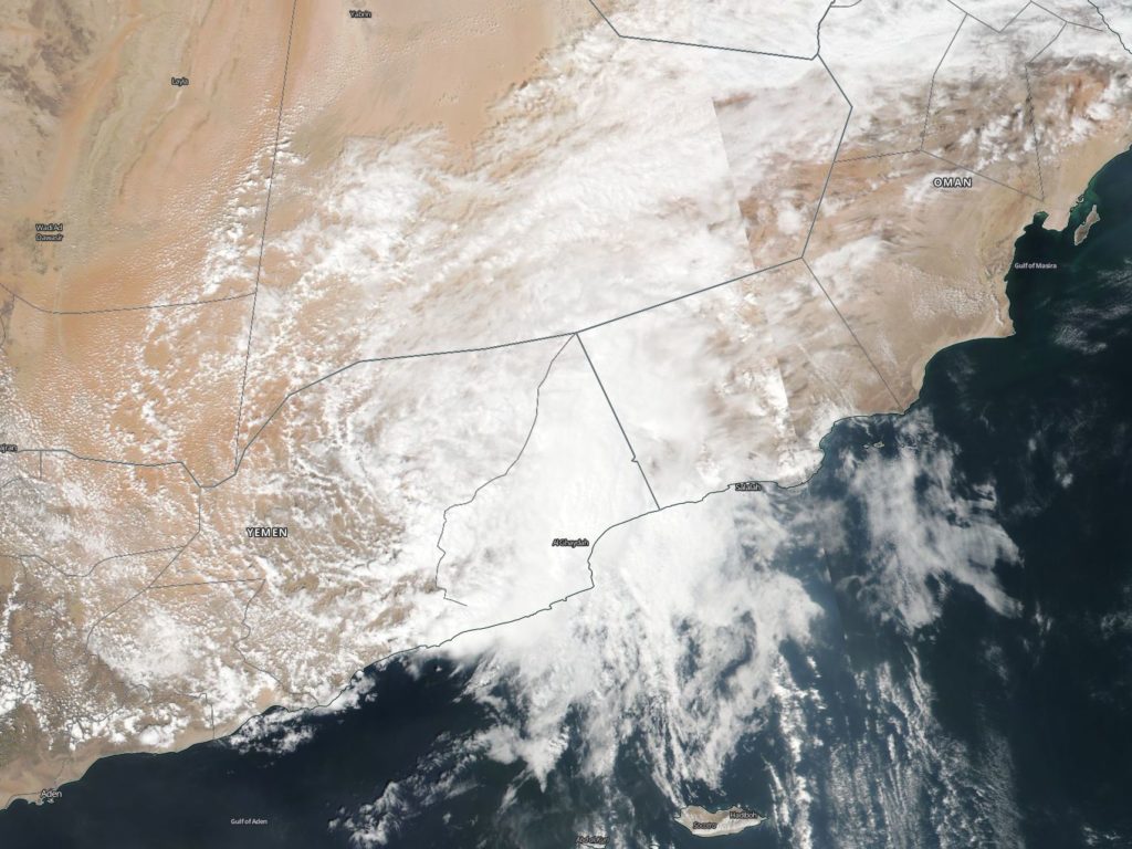
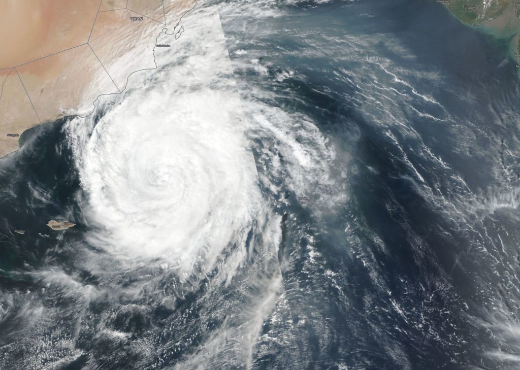
Suomi NPP image of Luban
On Oct. 15, NASA-NOAA’s Suomi NPP satellite passed over the Northern Indian Ocean and captured a visible image of the remnants of Tropical Cyclone Luban along the coast of Yemen and Oman. Credit: NASA Worldview, Earth Observing System Data and Information System (EOSDIS)/NOAA

On Oct. 14, Tropical Cyclone Luban made landfall in Yemen near the border with Oman. The storm made landfall between Mukalla and Al Ghaidahnear bringing heavy rainfall and causing flooding and power outages in the eastern city of Ghaida. According to the Oman Observer, the Salalah Airport reported 11mm rainfall while other areas reported much more. Sadah received 70.8 mm of rain and Dalkhout received 89.0 mm.

On Oct. 15, NASA-NOAA’s Suomi NPP satellite passed over the Northern Indian Ocean and the Visible Infrared Imaging Radiometer Suite (VIIRS) instrument provided a visible image the remnant clouds associated with former Tropical Cyclone Luban. Luban’s clouds lingered along the border or Yemen and Oman and into the Northern Indian Ocean.

The meteorological office in Yemen reported that seas would continue to be rough on Oct. 15.

By Rob Gutro
NASA’s Goddard Space Flight Center

Luban (Northern Indian Ocean) 2018

Oct. 12, 2018 – NASA Sees Tropical Cyclone Luban Nearing Oman

Tropical Cyclone Luban continued to track toward Oman as NASA-NOAA’s Suomi NPP satellite passed over the Northern Indian Ocean.

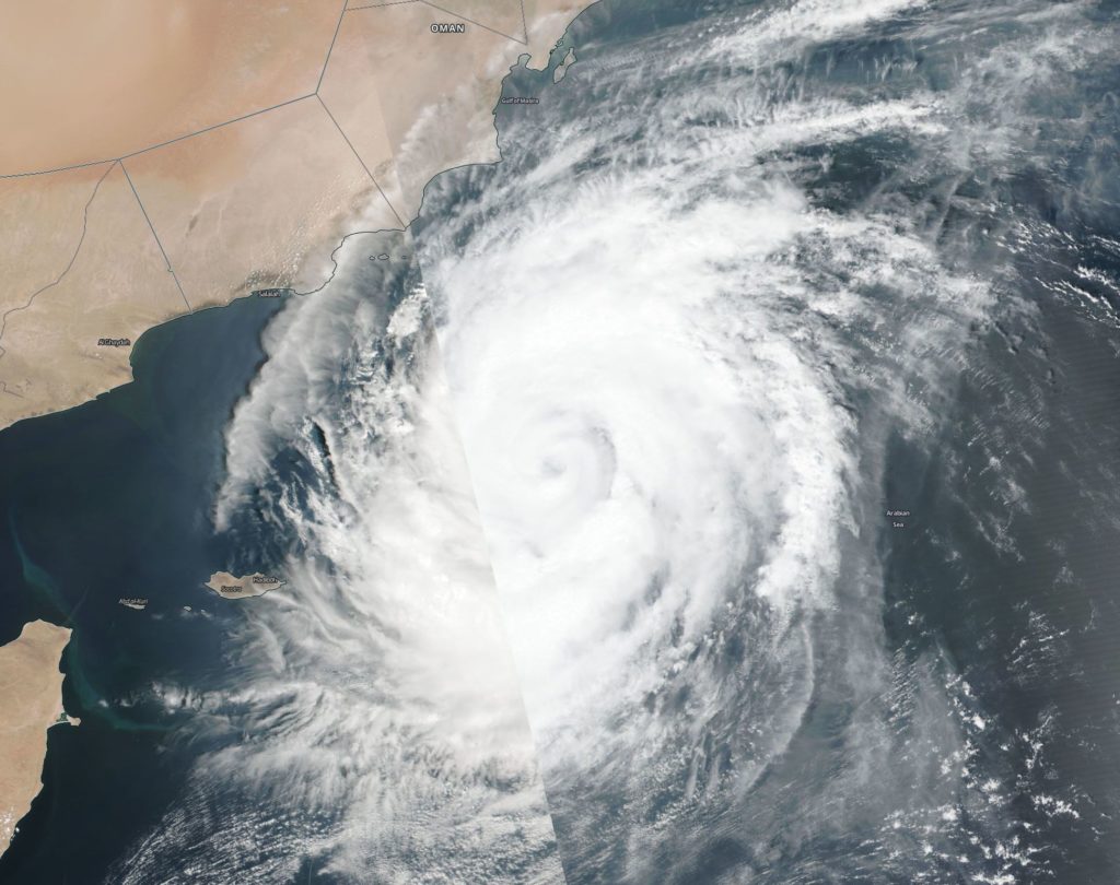
Suomi NPP image of Luban
NASA-NOAA’s Suomi NPP satellite passed over the Northern Indian Ocean and captured a visible image of Tropical Cyclone Luban nearing Oman’s coast on Oct. 11. Credit: NASA Worldview, Earth Observing System Data and Information System (EOSDIS)/NOAA

Suomi NPP passed over Luban on Oct. 11 and the Visible Infrared Imaging Radiometer Suite (VIIRS) instrument provided a visible image of the storm. The VIIRS image showed Luban stretched from the Gulf of Marisa south to Socotra Island. Luban had a symmetrical shape with a cloud-filled eye, surrounded by powerful thunderstorms.

At 11 a.m. EDT (1500 UTC), the center of Tropical Cyclone Luban was located near latitude 14.6 degrees north and longitude 56.8 degrees east. Luban was moving toward the west. Maximum sustained winds are near 52 mph (45 knots/83 kph) with higher gusts.

Luban is forecast to move north of Socotra Island and make landfall in Oman between Lukalla and Salalah on Oct. 14.

By Rob Gutro 
NASA’s Goddard Space Flight Center


Luban (North Indian Ocean) 2018

Oct. 11, 2018 – NASA Finds Tropical Cyclone Luban Crawling

NASA-NOAA’s Suomi NPP satellite provided a visible image of Tropical Cyclone Luban as it continued to spin over the Arabian Sea and slowly head toward Oman.

Suomi NPP image of Luban
NASA-NOAA’s Suomi NPP satellite provided this visible image of Tropical Cyclone Luban early on Oct. 10 when it was over the Arabian Sea, Northern Indian Ocean. Credit: NASA Worldview, Earth Observing System Data and Information System (EOSDIS)/ NOAA

The Visible Infrared Imaging Radiometer Suite (VIIRS) instrument aboard NASA-NOAA’s Suomi NPP satellite analyzed Tropical Cyclone Luban in visible light early on Oct. 10 when it was located in the Arabian Sea, Northern Indian Ocean. Although Luban remains symmetrical, there’s a lack of strong thunderstorm development within the system. The VIIRS image showed the hint of an eye that was cloud-filled while microwave imagery more clearly showed a large and ragged eye.

On Oct. 10 at 11 p.m. EDT (Oct. 11 at 0300 UTC) the Joint Typhoon Warning Center or JTWC noted Tropical Cyclone Luban had maximum sustained winds near 65 knots (75 mph/120 kph). It was centered near 14.5 degrees north latitude and 58.7 degrees east longitude, approximately 266 nautical miles southeast of Salah, Oman, India. Luban is moving very slowly to the west.

The JTWC forecast takes Luban westward where it will encounter increasing vertical wind shear and slightly cooler sea surface temperatures which will allow for a gradual decrease in intensity. Luban is forecast to make landfall shortly before Oct. 14 in Oman as a tropical storm.

By Rob Gutro
NASA’s Goddard Space Flight Center

Luban (Arabian Sea) 2018

Oct. 10, 2018 – Satellite Sees Tropical Cyclone Luban Nearing Oman

Tropical Cyclone Luban continued to move through the Arabian Sea toward the coast of Oman when the NOAA-20 satellite provided a visible image of the storm.

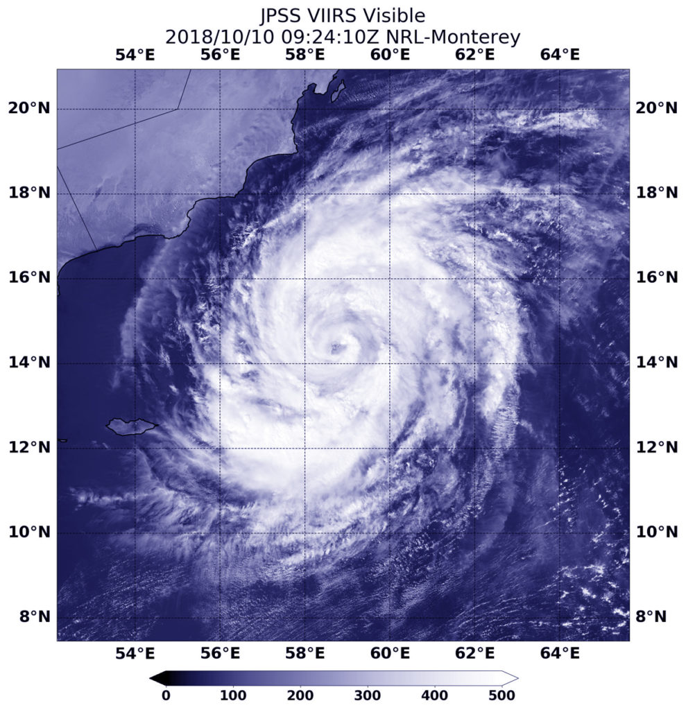
NOAA-20 image of Luban
NOAA’s NOAA-20 satellite passed over the Northern Indian Ocean and captured a visible image of Tropical Cyclone Luban in the Arabian Sea, off the coast of Oman. Credit: NOAA/NRL

NOAA-20 passed over Luban on Oct. 10 at 5:24 a.m. EDT (0924 UTC) and the VIIRS instrument provided a visible image. The VIIRS instrument also flies aboard NASA-NOAA’s Suomi NPP satellite. The VIIRS image showed Luban had developed an eye that was surrounded by powerful storms. The Joint Typhoon Warning Center noted “Animated enhanced infrared satellite imagery shows the system has maintained deep central convection with spiral bands wrapped tightly toward the center.”

At 11 a.m. EDT (1500 UTC) Tropical cyclone Luban was located near 14.4 degrees north latitude and 58.5 degrees east longitude. That’s about 298 nautical miles east-southeast of Salalah, Oman. Luban is moving to the west-northwest and has maximum sustained winds near 75 knots

Luban is forecast to maintain current strength as it moves northwest, later to the west. The storm is expected to weaken before approaching the coast of Yemen. Luban is forecast to make landfall east of Mukalla, and dissipate inland.

By Rob Gutro 
NASA’s Goddard Space Flight Center

Luban (Northern Indian Ocean) 2018

Oct. 09, 2018 – A NASA Infrared View at Arabian Sea’s Tropical Cyclone Luban

NASA’s Aqua satellite analyzed Tropical Cyclone Luban with infrared light to determine if the storm was intensifying or weakening. Luban formed on Oct. 8 in the Arabian Sea, Northern Indian Ocean and threatens Oman.

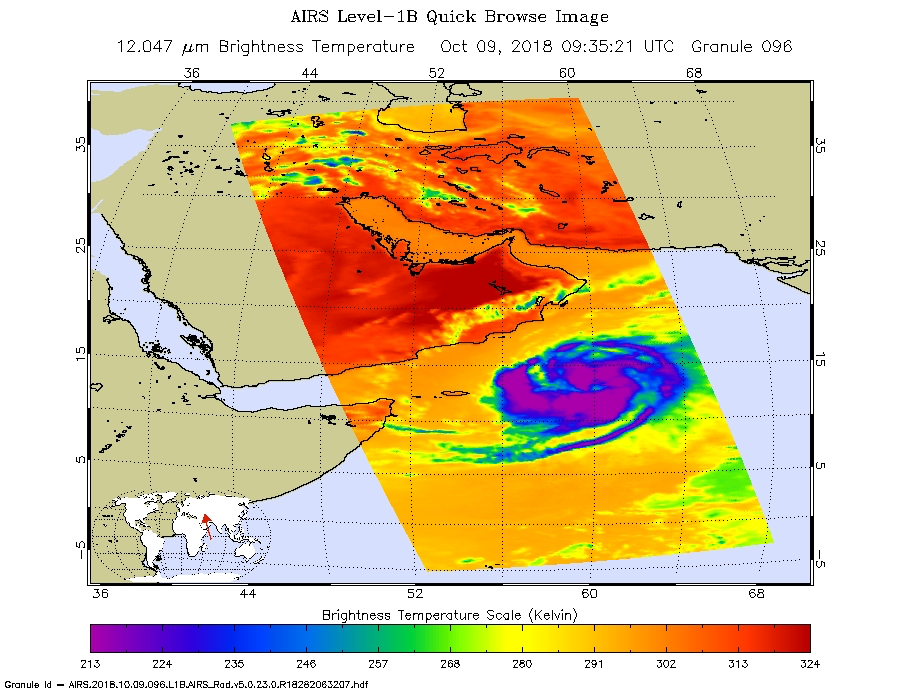
AIRS image of Luban
NASA’s Aqua satellite provided an infrared picture of Tropical Cyclone Luban’s cloud top temperatures from Oct. 9 at 5:35 a.m. EDT (0935 UTC). Strongest storms circled the center (purple) and appeared in thick bands of thunderstorms northeast and southwest of the center. Credit: NASA JPL, Heidar Thrastarson

The Atmospheric Infrared Sounder or AIRS instrument aboard NASA’s Aqua satellite passed over Luban on Oct. 9 at 5:35 a.m. EDT (0935 UTC).  AIRS uses infrared light and infrared light provides scientists with temperature data and that’s important when trying to understand how strong storms can be. The higher the cloud tops, the colder and the stronger they are. So infrared light as that gathered by the AIRS instrument can identify the strongest areas of a tropical cyclone.

At the time Aqua passed overhead, coldest cloud top temperatures in thunderstorms appeared around the center and in thick bands of thunderstorms northeast and southwest of the center. Those temperatures were as cold as or colder than minus 63 degrees Fahrenheit (minus 53 degrees Celsius). The Joint Typhoon Warning Center noted that satellite data also shows a slowly consolidating system with weak, fragmented, but very expansive rain bands feeding into an obscured center.

At 5 a.m. EDT (0900 UTC), the center of Luban was located near latitude 13.2 degrees north and longitude 60.1 degrees east. That’s 416 nautical miles east-southeast of Salalah, Oman. Luban is moving toward the west-northwest. Maximum sustained winds were near 55 knots (63 mph/102 kph). Luban is forecast to intensify to 65 knots (74 mph) and make hurricane strength as it moves west-northwest and later west.

The storm will weaken before approaching the coasts of Oman and Yemen on Friday, Oct. 12.

More information about AIRS can be found at airs.jpl.nasa.gov.

By Rob Gutro
NASA’s Goddard Space Flight Center