Matmo – Northern Indian Ocean (was South China Sea)

Nov. 08, 2019 – NASA Finds a Stronger Matmo Headed for Landfall

Matmo strengthened from a tropical storm to a storm with hurricane-force in the overnight hours of Nov. 7 into Nov. 8. NASA-NOAA’s Suomi NPP satellite passed over the Bay of Bengal, Northern Indian Ocean and found Matmo appeared more organized. Warnings are in effect in northeastern India and Bangladesh as Matmo approaches.
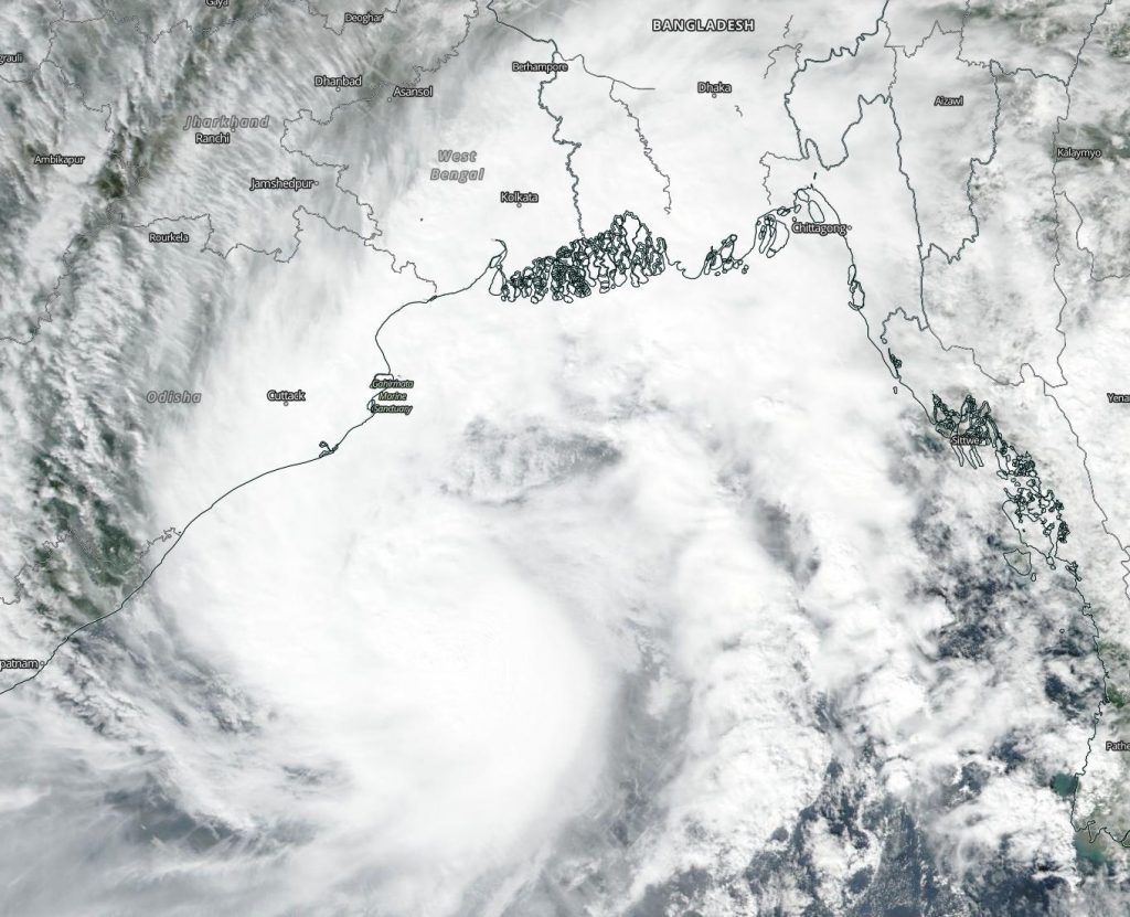
Suomi NPP image of Matmo
NASA-NOAA’s Suomi NPP satellite passed over Cyclone Matmo on Nov. 8 and captured a visible image of the storm in the Bay of Bengal. Credit: NASA Worldview, Earth Observing System Data and Information System (EOSDIS)

Visible imagery from the Visible Infrared Imaging Radiometer Suite (VIIRS) instrument aboard NASA-NOAA’s Suomi NPP satellite on Nov. 8 showed Matmo appeared more circular indicating it may have intensified. The imagery also showed a large band on thunderstorms extending north from the center of circulation and over northeastern India and Bangladesh.

The satellite imagery showing better organization complemented the increase in Matmo’s maximum sustained winds. Sustained winds on Nov. 7 were near 55 knots (63 mph/102 kph). On Nov. 8 at 10 a.m. EST (1500 UTC), Matmo’s maximum sustained winds had increased to near 85 knots (98 mph/157 kph). Matmo was located near latitude 19.1 degrees north and longitude 88.1 degrees east, about 235 nautical miles south of Kolkata, India. Matmo is moving to the north.

Suomi NPP captures all three storms
NASA-NOAA’s Suomi NPP satellite provided a panoramic image of 3 tropical cyclones in the northern hemisphere. Cyclone Matmo (left) in the Bay of Bengal, Northern Indian Ocean, Typhoon Nakri (center) in the South China Sea, and Tropical Storm Halong (right) in the Northwestern Pacific Ocean. Credit: NASA Worldview, Earth Observing System Data and Information System (EOSDIS)

The India Meteorological Service (IMS) has issued a cyclone watch for the Odisha-West Bengal coasts. Odisha is a state in India. Odisha has 301 miles (485 kilometers) of coastline along the Bay of Bengal from Balasore to Ganjam. West Bengal is on the eastern bottleneck of India. It extends from the Himalayas (in the north) to the Bay of Bengal in the south. IMS said, “Matmo is expected to cross the West Bengal – Bangladesh Coasts between Sagar Islands (West Bengal) and Khepupara (Bangladesh), across Sunderban delta by midnight of November 9 [local time].”

The Joint Typhoon Warning Center expects Matmo to make landfall near the border of India and Bangladesh on Saturday, Nov. 9 and continue moving inland.

Typhoons and hurricanes are the most powerful weather event on Earth. NASA’s expertise in space and scientific exploration contributes to essential services provided to the American people by other federal agencies, such as hurricane weather forecasting.

By Rob Gutro 
NASA’s Goddard Space Flight Center

Matmo – Northern Indian Ocean (was South China Sea)

Nov. 07, 2019 – NASA Observes Tropical Storm Matmo in North Central Bay of Bengal

NASA-NOAA’s Suomi NPP satellite passed over the Bay of Bengal, Northern Indian Ocean and found that Tropical Storm Matmo was positioned in the center of that body of water.

Suomi NPP image of Matmo
NASA-NOAA’s Suomi NPP satellite passed over Tropical Storm Matmo on Nov. 7 and captured a visible image of the storm in the Bay of Bengal. Credit: NASA Worldview, Earth Observing System Data and Information System (EOSDIS)

Visible imagery from the Visible Infrared Imaging Radiometer Suite (VIIRS) instrument aboard NASA-NOAA’s Suomi NPP satellite on Nov. 7 showed Matmo appeared somewhat elongated from north to south, because of a large band on thunderstorms extending north from the center of circulation.

On Nov. 7 at 4 a.m. EST (0900 UTC), Matmo had maximum sustained winds near 55 knots (63 mph/102 kph). Matmo was located near latitude 15.0 degrees north and longitude 88.7 degrees east, about 353 nautical miles east-southeast of Visakhapatnam, India. Matmo is moving to the northwest.

The Joint Typhoon Warning Center expects Matmo will move northwest, then later, north. The storm will strengthen to 85 knots, but will weaken rapidly to dissipate on approach to the north coast of the Bay of Bengal. Threatened landmasses include India and Bangladesh.

The India Meteorological Service has issued a cyclone watch for the Odisha-West Bengal coasts. Odisha is a state in India. Odisha has 301 miles (485 kilometers) of coastline along the Bay of Bengal from Balasore to Ganjam. West Bengal is on the eastern bottleneck of India. It extends from the Himalayas (in the north) to the Bay of Bengal in the south.

Matmo is forecast to make landfall just east of Kolkata on Nov. 9. Kolkata is the capital of the Indian state of West Bengal.

Typhoons and hurricanes are the most powerful weather event on Earth. NASA’s expertise in space and scientific exploration contributes to essential services provided to the American people by other federal agencies, such as hurricane weather forecasting.

By Rob Gutro 
NASA’s Goddard Space Flight Center

Matmo – Northern Indian Ocean (was South China Sea)

Nov. 05, 2019 – NASA Tracking Remnants of Tropical Cyclone Matmo

NASA’s Aqua satellite captured an image of the remnants of Tropical Cyclone Matmo in the Northern Indian Ocean is it headed north toward Bangladesh. The visible image showed that the low pressure area appeared better organized and forecasters are watching it for regeneration. Matmo is known in Pakistan as Tropical Cyclone Bulbul.

Aqua image of Matmo
On Nov. 5 at 2:05 a.m. EDT (0705 UTC) the MODIS instrument that flies aboard NASA’s Aqua satellite provided a visible image of Matmo’s remnants. The MODIS image showed that the low pressure area is developing thunderstorms around its center and western quadrant. Credit: NASA/NRL

Over the past week, Matmo made landfall in Vietnam and continued moving west where it re-emerged into the Andaman Sea, Northern Indian Ocean.  On Nov. 4 at 1 p.m. EDT (1800 UTC) Matmo’s center of circulation was located near latitude 13.3 degrees north and longitude 92.2 degrees east. That’s about 514 nautical miles south of Chittagong, Bangladesh.

The Joint Typhoon Warning Center noted that, “Global computer models are depicting a slow-developing system reaching 35 knots (40 mph/65 kph) after 72 hours while on a meandering north-northwestward track. Development potential for the remnants of 23W (Matmo) is being assessed as ‘medium’ based on its current structure, despite the late formation timeline in global models.” Maximum sustained surface winds were estimated at 20 knots (23 mph/37 kph) to 25 knots (29 mph/46 kph).

On Nov. 5 at 2:05 a.m. EDT (0705 UTC) the Moderate Imaging Spectroradiometer or MODIS instrument that flies aboard NASA’s Aqua satellite provided a visible image of Matmo’s remnants. The MODIS image showed the low pressure area is developing thunderstorms around its center and western quadrant. Forecasters are looking at the visible imagery, in addition to other satellite imagery, to determine if the storm has regenerated.

JTWC noted that the potential for the development of a significant tropical cyclone within the next 24 hours has upgraded to medium.

NASA’s Aqua satellite is one in a fleet of NASA satellites that provide data for hurricane research.

Hurricanes are the most powerful weather event on Earth. NASA’s expertise in space and scientific exploration contributes to essential services provided to the American people by other federal agencies, such as hurricane weather forecasting.

For updated forecasts, visit: https://www.nhc.noaa.gov

By Rob Gutro
NASA’s Goddard Space Flight Center

Matmo – South China Sea

Oct. 30, 2019 – NASA Finds Tropical Storm Matmo Consolidating off Vietnam Coast

NASA-NOAA’s Suomi NPP satellite captured an image of Tropical Storm Matmo as it developed in the South China Sea, off the coast of Vietnam. The storm is expected to make a landfall in central southeastern Vietnam later on Oct. 30.

Suomi NPP image of Matmo
NASA-NOAA’s Suomi NPP satellite passed over Tropical Storm Matmo in the South China Sea on Oct. 30 as it was nearing the coast of southeastern central Vietnam. Credit: NASA Worldview, Earth Observing System Data and Information System (EOSDIS)

Visible imagery from NASA satellites help forecasters understand if a storm is organizing or weakening. The Visible Infrared Imaging Radiometer Suite (VIIRS) instrument aboard Suomi NPP provided a visible image of Matmo on Oct. 30 and found the storm taking on a much more rounded shape than the previous day.

The shape of the storm is a clue to forecasters that a storm is either strengthening or weakening. If a storm takes on a more rounded shape it is getting more organized and strengthening. Conversely, if it becomes less rounded or elongated, it is a sign the storm is weakening.

At 5 a.m. EDT (0900 UTC) on Oct. 30, the center of Matmo was near latitude 13.2 degrees north and longitude 111.0 degrees east. The post-tropical cyclone was moving toward the west-northwest. Maximum sustained winds associated with this system are near 46 mph (40 knots/74 kph) with higher gusts.

Vietnam’s National Centre for Hydro-Meteorological Forecasting (NCHMF) has posted a tropical storm warning for southeast central Vietnam. Matmo is expected to make landfall near Nha Trang. Nha Trang lies on the coast and is the capital of the Khanh Hoa Province, on the South Central Coast of Vietnam.

The Joint Typhoon Warning Center expects that Matmo will move west-northwest to make landfall in Vietnam later in the day.

Hurricanes are the most powerful weather event on Earth. NASA’s expertise in space and scientific exploration contributes to essential services provided to the American people by other federal agencies, such as hurricane weather forecasting.

For updated forecasts from the National Centre for Hydro-Meteorological Forecasting (NCHMF), visit: http://www.nchmf.gov.vn/

By Rob Gutro 
NASA’s Goddard Space Flight Center