Oscar (Atlantic Ocean)

Nov. 01, 2018 – NASA Sees Hurricane Oscar Transitioning To Extratropical Low

Hurricane Oscar has transitioned into an extra-tropical low pressure area in the northeastern Atlantic Ocean. The Global Precipitation Measurement mission or GPM core satellite provided a look at rainfall occurring within the storm.
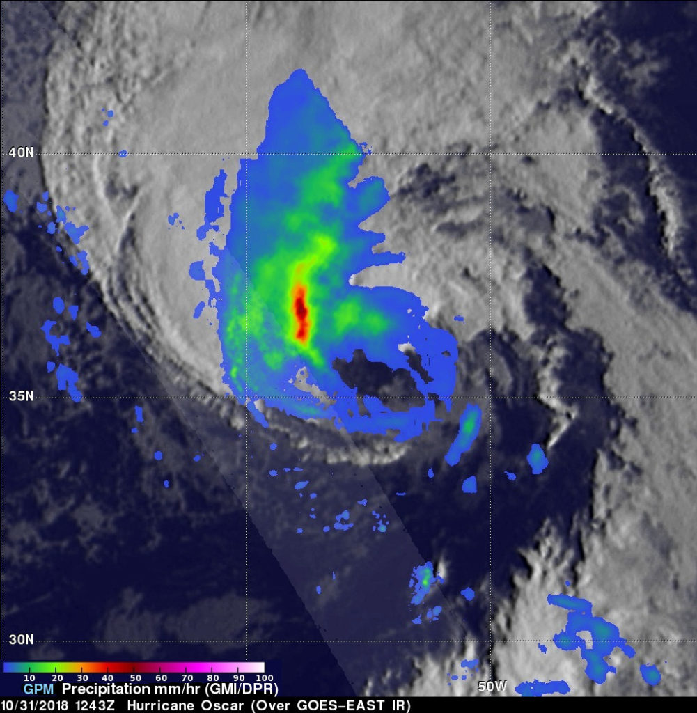
GPM image of Oscar
On October 31, 2018 at 8:43 a.m. EDT (1243 UTC) the GPM core observatory satellite showed the heaviest convective rainfall was located well northwest of Oscar’s low level center of circulation. Rain was falling at a rate of about 2 inches (50.8 mm) per hour in that area. On the western side, few storm tops were reaching heights above 5.6 miles (9.0 km) but contained heavy downpours. Credit: NASA/JAXA, Hal Pierce

When a storm becomes extra-tropical, it means that a tropical cyclone has lost its “tropical” characteristics. The National Hurricane Center defines “extra-tropical” as a transition that implies both poleward displacement (meaning it moves toward the north or south pole) of the cyclone and the conversion of the cyclone’s primary energy source from the release of latent heat of condensation to baroclinic (the temperature contrast between warm and cold air masses) processes. It is important to note that cyclones can become extratropical and still retain winds of hurricane or tropical storm force.

On October 31, 2018 at 8:43 a.m. EDT (1243 UTC) the GPM core observatory satellite had a pass over hurricane Oscar. The hurricane had maximum sustained winds of about 74.8 mph (65 knots) and was moving toward the northeast while becoming more extratropical in appearance. GPM’s Microwave Imager (GMI) showed that the heaviest convective rainfall was located well northwest of the low level center of circulation. Rain was falling at a rate of about 2 inches (50.8 mm) per hour in that area.
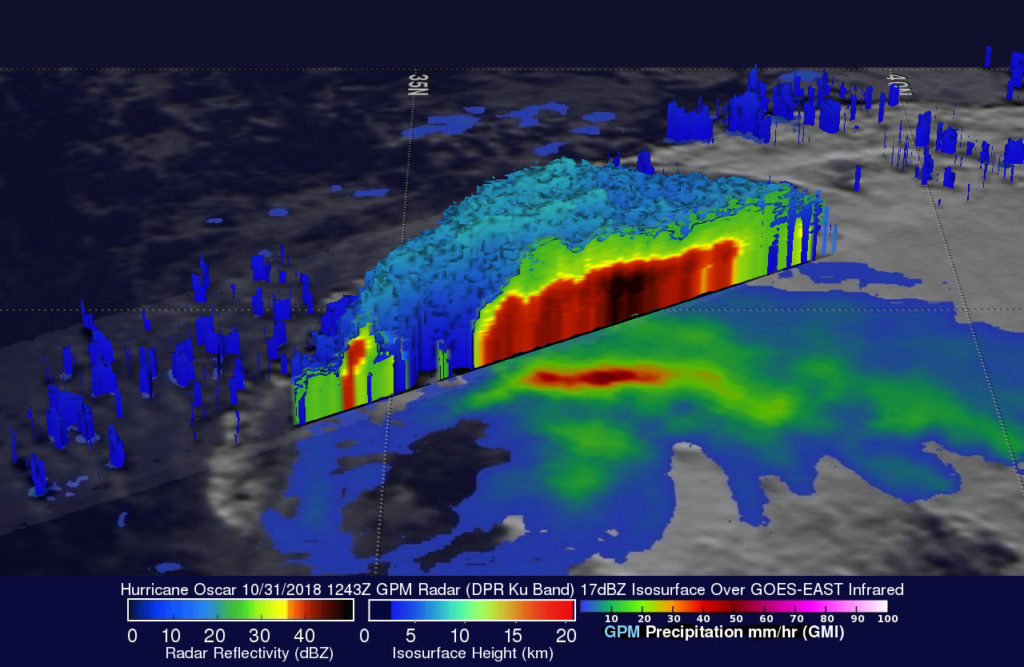
GPM 3-D image of Oscar
On October 31, 2018 at 8:43 a.m. EDT (1243 UTC) the GPM core observatory satellite showed the heaviest convective rainfall was located well northwest of Oscar’s low level center of circulation. Rain was falling at a rate of about 2 inches (50.8 mm) per hour in that area. On the western side, few storm tops were reaching heights above 5.6 miles (9.0 km) but contained heavy downpours. Credit: NASA/JAXA, Hal Pierce

At NASA’s Goddard Space Flight Center in Greenbelt, Md. a simulated 3-D view was created from GPM data looking from the east toward the storm. The image was derived from GPM’s radar (DPR Ku Band) data. GPM’s radar swath (DPR Ku Band) passed through storms on Oscar’s western side. GPM’s DPR found that very few storm tops were reaching heights above 5.6 miles (9.0 km) but heavy downpours were returning strong radar reflectivity values to the GPM satellite. Radar reflectivity values were frequently observed in the 3D cross-section through heavy rainfall in the northwestern side of the hurricane. GPM is a joint mission between NASA and the Japan Aerospace Exploration Agency, JAXA.

Oscar is now an extra-tropical low pressure area and is expected to pass northwest of Ireland over the weekend of Nov. 3 and 4 and will bring winds and rain to the country.

By Harold F. Pierce / Rob Gutro
NASA Goddard Space Flight Center

Oscar (Atlantic Ocean)

Oct. 31, 2018 – NASA Gets An Infrared View of Hurricane Oscar

NASA’s Aqua satellite passed over the North Atlantic Ocean and gathered temperature data on Hurricane Oscar. The data showed the bulk of strong storms were in the northwestern quadrant as Oscar began transitioning into an extra-tropical storm.

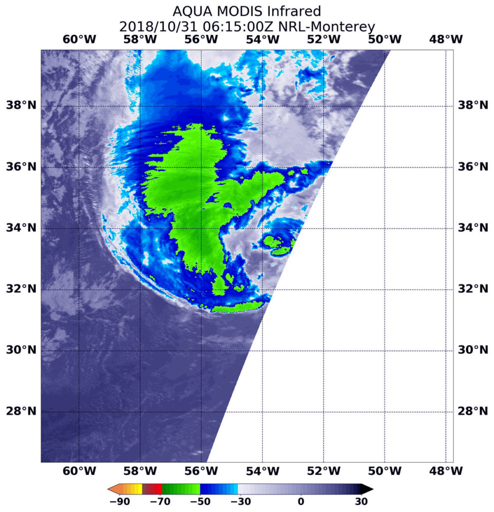
Aqua image of Oscar
At 2:15 a.m. EDT (0615 UTC) on Oct. 31, the MODIS instrument that flies aboard NASA’s Aqua satellite gathered infrared data on Hurricane Oscar. Strongest thunderstorms circled the center and were in a thick band west of center where cloud top temperatures were as cold as minus 63 degrees Fahrenheit (minus 53 Celsius). Credit: NASA/NRL

On Oct. 31 at 2:15 a.m. EDT (0615 UTC) the MODIS instrument that flies aboard NASA’s Aqua satellite gathered infrared data on Oscar. Infrared data provides temperature information. Strongest thunderstorms were west and northwest of the center where MODIS found cloud top temperatures as cold as minus 63 degrees Fahrenheit (minus 53 Celsius). NASA research has shown that cloud tops with temperatures that cold were high in the troposphere and have the ability to generate heavy rain.

At 5 a.m. EDT (0900 UTC) on Oct. 31 the center of Hurricane Oscar was located near latitude 34.1 degrees north and longitude 53.6 degrees west.  That’s about 660 miles (1,060 km) east-northeast of Bermuda. Oscar is moving toward the northeast near 22 mph (35 kph).  A faster north-northeast to northeast motion is expected during the next few days.  Maximum sustained winds have decreased to near 75 mph (120 kph) with higher gusts.  The estimated minimum central pressure is 982 millibars.

The National Hurricane Center noted at 11 a.m. EDT (1500 UTC), “Oscar is quickly transforming into an extratropical low.  Although there is still a little bit of deep convection just north of the center, a more prominent cloud shield extends northward from the western part of the circulation.”

NOAA’s GOES-16 satellite imagery showed Oscar’s center nearly embedded within a frontal zone and cold air moving into the back side of the system.

Oscar is expected to become an extratropical low over the north-central Atlantic Ocean by tonight, Oct. 31 (EDT).  Although gradual weakening is expected during the next several days, Oscar is expected to remain a powerful post-tropical cyclone over the north-central and northeastern Atlantic Ocean into the weekend.

Although far from land, large swells generated by Oscar will affect Bermuda through Wednesday, Oct. 31.

For updated forecasts, visit: www.nhc.noaa.gov

By Rob Gutro
NASA’s Goddard Space Flight Center

Oscar (Atlantic Ocean)

Oct. 30, 2018 – Hurricane Oscar on Satellite Imagery: A One-Eyed Little Monster with a Tail

Of course, tropical cyclones have one eye and with Halloween on the horizon, false-colored infrared imagery from NASA’s Aqua satellite brought out that eye in this small tropical monster with a tail of thunderstorms.

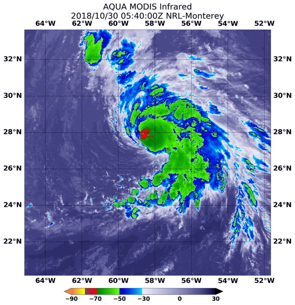
Aqua image of Oscar
NASA’s Aqua satellite showed cloud top temperatures in strongest storms around Oscar’s eye were as cold as or colder than minus 70 degrees (red) Fahrenheit (minus 56.6 degrees Celsius). A fragmented band of thunderstorms wrapping into the center of circulation from the southeast gave the storm an appearance of having a tail. Credit: NASA/NRL

When NASA’s Aqua satellite passed over the Central Atlantic Ocean, it took Hurricane Oscar’s cloud top temperatures that helped forecasters key into where the strongest side of the storm was located.

Cloud top temperatures determine strength of the thunderstorms that make up a tropical cyclone. The colder the cloud top, the stronger the uplift in the storm that helps thunderstorm development. Basically, infrared data helps determine where the most powerful storms are within a tropical cyclone.

The Moderate Resolution Imaging Spectroradiometer or MODIS instrument aboard Aqua provided that infrared data on Oct. 30 at 1:40 a.m. EDT (0540 UTC) MODIS data showed cloud top temperatures in strongest storms around Oscar’s eye were as cold as or colder than minus 70 degrees Fahrenheit (minus 56.6 degrees Celsius). NASA research indicates very cold cloud tops with the potential to generate very heavy rainfall.

The National Hurricane Center or NHC said ” Cloud-top temperatures have warmed a bit overall, and the convective pattern is becoming more asymmetric as dry air is infiltrating the southern and eastern part of Oscar’s circulation.  However, the hurricane is still producing plenty of inner-core convection and some lightning strikes.”

A fragmented band of thunderstorms wrapping into the center of circulation from the southeast gave the storm an appearance of having a tail.

MODIS imagery also showed that Oscar is a small storm. Hurricane-force winds extend outward up to 25 miles (35 km) from the center, and tropical-storm-force winds extend outward up to 90 miles (150 km).

At 11 a.m. EDT (1500 UTC) on Oct. 30 the center of Hurricane Oscar was located near latitude 29.7 North, longitude 57.7 West.  Oscar is moving toward the north-northeast near 14 mph (22 kph).  A north-northeastward or northeastward motion with an increase in forward speed is expected through Friday. Maximum sustained winds are near 100 mph (155 kph) with higher gusts. The estimated minimum central pressure is 972 millibars.

Gradual weakening is forecast during the next several days, but Oscar is expected to become a powerful extratropical low over the north-central Atlantic Ocean by late Wednesday, Oct. 31.

For updated forecasts, visit: www.nhc.noaa.gov

By Rob Gutro
NASA’s Goddard Space Flight Center

Oscar (Atlantic Ocean)

Oct. 29, 2018 – Atlantic’s Hurricane Oscar’s Water Vapor Measured by NASA’s Terra Satellite

When NASA’s Terra satellite passed over the Central Atlantic Ocean on Oct. 16 the MODIS instrument aboard analyzed water vapor within Tropical Storm Oscar.

Terra image of Oscar
NASA’s Terra satellite passed over Hurricane Oscar in the Atlantic Ocean On Oct. 29 at 10:20 a.m. EDT (1420). The MODIS instrument showed highest concentrations of water vapor (brown) and coldest cloud top temperatures were around the center (over water) and in the eastern quadrant. Credits: NASA/NRL

Oscar formed as a subtropical storm in the central North Atlantic Ocean on Friday, Oct. 26 at 11 p.m. EDT. Over the weekend of Oct. 27 and 28, Oscar took on tropical characteristics and strengthened into a hurricane.

On Oct. 29 at 10:20 a.m. EDT (1420) NASA’s Terra satellite passed over Oscar and provided visible and water vapor imagery of the newest Atlantic Hurricane.

Water vapor analysis of tropical cyclones tells forecasters how much potential a storm has to develop and shows where the heaviest rainfall may be found. Water vapor releases latent heat as it condenses into liquid. That liquid becomes clouds and thunderstorms that make up a tropical cyclone. Temperature is important when trying to understand how strong storms can be. The higher the cloud tops, the colder and the stronger they are.

Terra image of Oscar
NASA’s Terra satellite passed over Hurricane Oscar in the Atlantic Ocean On Oct. 29 at 10:20 a.m. EDT (1420). The MODIS instrument showed a clear eye surrounded by powerful thunderstorms. Fragmented bands of thunderstorms in the eastern quadrant. Credits: NASA/NRL

The Moderate Resolution Imaging Spectroradiometer or MODIS instrument aboard Terra gathered water vapor content and temperature information. The MODIS image showed highest concentrations of water vapor and coldest cloud top temperatures circled the center and extended east. MODIS saw coldest cloud top temperatures were as cold as minus 70 degrees Fahrenheit (minus 56.6 degrees Celsius) in those areas. Storms with cloud top temperatures that cold have the capability to produce heavy rainfall.

Visible imagery from MODIS showed a clear eye surrounded by powerful thunderstorms. Fragmented bands of thunderstorms in the eastern quadrant.

The National Hurricane Center said “Oscar’s convective cloud pattern has continued to improve since the previous advisory, with a small, cloud-filled eye now apparent in visible satellite imagery and also in a recent microwave pass. In addition, cirrus outflow has been expanding in all quadrants, especially in the eastern semicircle.”

The National Hurricane Center or NHC said at 11 a.m. EDT (1500 UTC)   the eye of Hurricane Oscar was located near latitude 25.8 degrees north and longitude 58.4 degrees west. That’s about 590 miles (955 km) southeast of Bermuda. Oscar is moving toward the west-northwest near 7 mph (11 kph).  A turn toward the northwest at a slower forward speed is expected later today, followed by a motion toward the north tonight.  Maximum sustained winds have increased to near 85 mph (140 kph) with higher gusts.  Additional strengthening is forecast through Tuesday, followed by gradual weakening thereafter. The estimated minimum central pressure is 981 millibars.

On Tuesday, Oct. 30, Oscar is forecast to begin moving toward the north-northeast with an increase in forward speed.  The hurricane is then expected to accelerate quickly toward the northeast through the middle of the week.

For updated forecasts, visit: www.nhc.noaa.gov.

By Rob Gutro
NASA’s Goddard Space Flight Center