Paulette – Atlantic Ocean

Sep. 23, 2020 – NASA’s Terra Satellite Confirms Paulette’s Second Post-Tropical Transition

NASA’s Terra satellite passed over post-tropical storm Paulette after it had transitioned for a second time. Using infrared imagery, Terra found no strong storms remained.

Terra image of Paulette
On Sept. 23 at 8:45 a.m. EDT (1245 UTC), the MODIS instrument that flies aboard NASA’s Terra satellite gathered infrared data on Paulette and showed it was devoid of strong storms. Imagery revealed a small area of convection (yellow) where cloud top temperatures are as cold as minus 50 degrees Fahrenheit (minus 45.5 Celsius). Credit: NASA/NRL

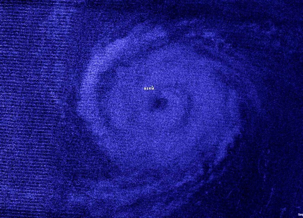
Paulette has had quite a history. Paulette formed in the Central Atlantic Ocean on Sept. 6 as Tropical Depression Seventeen and became a tropical storm the next day. Paulette became a hurricane on Sept. 12. As a hurricane, Paulette’s eye passed directly over Bermuda, then weakened and became a post-tropical cyclone on Sept. 16 in the North Atlantic Ocean when it was located 450 miles (725 km) east-southeast of Cape Race Newfoundland, Canada. A Post-Tropical Storm is a generic term for a former tropical cyclone that no longer possesses sufficient tropical characteristics to be considered a tropical cyclone. Then on Sept. 22, the remnants of Paulette organized and re-formed into a tropical storm. Only to devolve again to a post-tropical storm later that day.

At 11 p.m. EDT on Sept. 22 (0300 UTC on Sept. 23), Dan Brown, Warning Coordination Meteorologist, Senior Hurricane Specialist at NOAA’s National Hurricane Center in Miami, Fla. noted, “Paulette had been devoid of deep convection since early Tuesday and the shallow convection mentioned in the previous advisory has also waned. Therefore, Paulette has again become a post-tropical cyclone.”

NASA’s Terra Satellite Examines Paulette

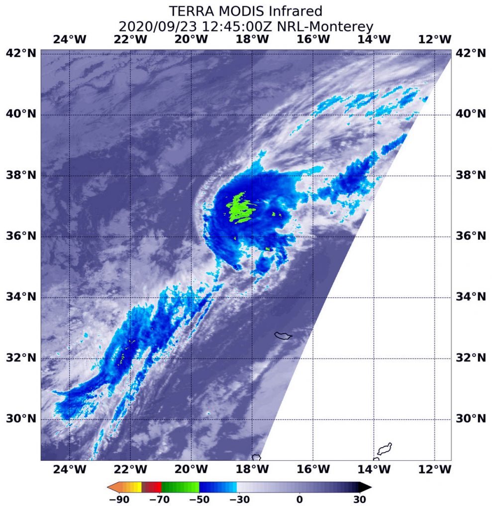
NASA’s Terra satellite uses infrared light to analyze the strength of storms by providing temperature information about the system’s clouds. The strongest thunderstorms that reach high into the atmosphere have the coldest cloud top temperatures.

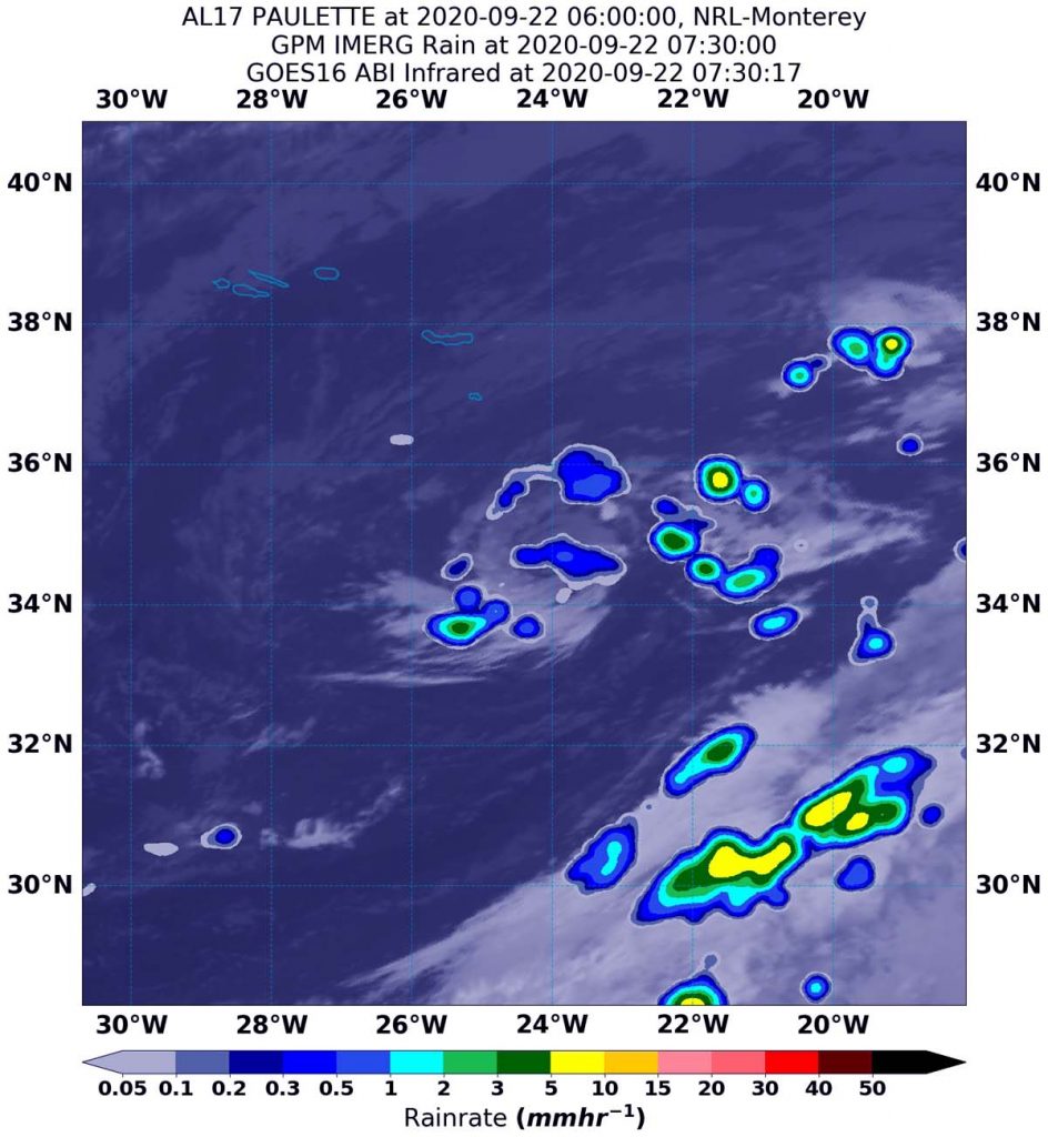
On Sept. 23 at 8:45 a.m. EDT (1245 UTC), the Moderate Resolution Imaging Spectroradiometer or MODIS instrument that flies aboard NASA’s Terra satellite gathered infrared data on Paulette. There were no strong storms on the infrared MODIS imagery. The imagery found only one small area of convection where cloud top temperatures are as cold as minus 50 degrees Fahrenheit (minus 45.5 Celsius).

Final Status of Paulette

The last public advisory issued by the National Hurricane Center on Paulette was posted on Sept. 22 at 11 p.m. EDT (0300 UTC). At that time, the center of Post-Tropical Cyclone Paulette was located near latitude 34.8 degrees north and longitude 20.0 degrees west. That is about 445 miles (720 km) east-southeast of the Azores Islands.  The Azores Islands are a Portuguese archipelago in the North Atlantic Ocean. They are located about 930 miles (1,500 km) from Lisbon, Portugal.

Maximum sustained winds are near 40 mph (65 kph) with higher gusts. Slow weakening is forecast. The post-tropical cyclone was moving toward the east near 12 mph (19 kph). An eastward to east-northeastward motion is forecast through midday Wednesday. A decrease in the forward motion along with turns to the southeast then south are expected late Wednesday through Thursday. A west-southwestward motion is forecast to begin by late this week.

Paulette’s Final Forecast  

Post-tropical cyclone Paulette is expected to become a remnant low later today, Sept. 23.

NASA Researches Tropical Cyclones

Hurricanes/tropical cyclones are the most powerful weather events on Earth. NASA’s expertise in space and scientific exploration contributes to essential services provided to the American people by other federal agencies, such as hurricane weather forecasting.

For more than five decades, NASA has used the vantage point of space to understand and explore our home planet, improve lives and safeguard our future. NASA brings together technology, science, and unique global Earth observations to provide societal benefits and strengthen our nation. Advancing knowledge of our home planet contributes directly to America’s leadership in space and scientific exploration.

For updated forecasts. visit: www.nhc.noaa.gov

By Rob Gutro
NASA’s Goddard Space Flight Center

Paulette – Atlantic Ocean

Sep. 22, 2020 – NASA Sees Rebirth of Tropical Storm Paulette

Tropical Storm Paulette just reformed in the central North Atlantic Ocean today, Sept. 22. Using a NASA satellite rainfall product that incorporates data from satellites and observations, NASA estimated Paulette’s rainfall rates.

IMERG data on Paulette
On Sept. 22 at 3:30 a.m. EDT (0730 UTC), NASA’s IMERG estimated Tropical Storm Paulette was generating as much as (5 mm/0.20 inches of rain (yellow) around the center of circulation. The rainfall data was overlaid on infrared imagery from NOAA’s GOES-16 satellite. Credit: NASA/NOAA/NRL

Paulette was a hurricane whose eye passed directly over Bermuda, then weakened and became a post-tropical cyclone on Sept. 16 in the North Atlantic Ocean when it was located 450 miles (725 km) east-southeast of Cape Race Newfoundland, Canada. A Post-Tropical Storm is a generic term for a former tropical cyclone that no longer possesses sufficient tropical characteristics to be considered a tropical cyclone.

At 11 a.m. EDT (1500 UTC) on Sept.16 NOAA’s National Hurricane Center (NHC) issued the final advisory on Paulette but tracked its remnants over the last 6 days. NHC forecasters had assigned a medium chance that Paulette could redevelop over that time. At 11 p.m. EDT on Sept. 21 (0300 UTC on Sept. 22), Paulette regained tropical characteristics.

Paulette’s Status on Sept. 22

At 5 a.m. EDT (0900 UTC) on Sept. 22, the center of Tropical Storm Paulette was located near latitude 34.7 degrees north and longitude 23.7 degrees west. That is about 295 miles (470 km) southeast of the Azores Islands. The Azores islands are an autonomous region of Portugal in the mid-Atlantic.

Paulette was moving toward the east-northeast near 17 mph (28 kph). An east or east-northeast motion at a slower forward speed is expected through Wednesday. Paulette is then expected to turn southward and southwestward Wednesday night and Thursday.

Maximum sustained winds are near 60 mph (95 km/h) with higher gusts. Weakening is forecast during the next couple of days, and Paulette is expected to become post-tropical by Wednesday night or Thursday. The estimated minimum central pressure is 1002 millibars.

Estimating Paulette’s Rainfall Rates from Space

At 11 p.m. EDT on Sept. 21, deep convection and thunderstorm development associated with the post-tropical remnants of Paulette had become better organized over the past 6 to 12 hours. “An ASCAT over pass from a few hours ago indicate that increase in convective organization has resulted in strengthening and the system is being classified as a tropical cyclone once again,” noted Daniel Brown, senior hurricane specialist and warning coordination meteorologist at NOAA’s National Hurricane Center in Miami, Fla.

Four and a half hours later, NASA’s Integrated Multi-satellitE Retrievals for GPM or IMERG, which is a NASA satellite rainfall product, estimated rainfall occurring in the newly reformed tropical storm. On Sept. 22 at 3:30 a.m. EDT (0730 UTC) IMERG formed Paulette was generating as much as 5 mm (0.20 inches) of rain per hour around the center of circulation.

By 5 a.m. EDT (0900 UTC), the NHC noted that the tops of Paulette’s convective clouds have been warming since the previous advisory, and first-light visible images showed that a swirl of low- to mid-level clouds is about all that is left.

At the U.S. Naval Laboratory in Washington, D.C., the IMERG rainfall data was overlaid on infrared imagery from NOAA’s GOES-16 satellite to provide a full extent of the storm.

What Does IMERG Do?

This near-real time rainfall estimate comes from the NASA’s IMERG, which combines observations from a fleet of satellites, in near-real time, to provide near-global estimates of precipitation every 30 minutes. By combining NASA precipitation estimates with other data sources, we can gain a greater understanding of major storms that affect our planet.

What the IMERG does is “morph” high-quality satellite observations along the direction of the steering winds to deliver information about rain at times and places where such satellite overflights did not occur. Information morphing is particularly important over the majority of the world’s surface that lacks ground-radar coverage. Basically, IMERG fills in the blanks between weather observation stations.

NASA Researches Tropical Cyclones

Hurricanes/tropical cyclones are the most powerful weather events on Earth. NASA’s expertise in space and scientific exploration contributes to essential services provided to the American people by other federal agencies, such as hurricane weather forecasting.

For more than five decades, NASA has used the vantage point of space to understand and explore our home planet, improve lives and safeguard our future. NASA brings together technology, science, and unique global Earth observations to provide societal benefits and strengthen our nation. Advancing knowledge of our home planet contributes directly to America’s leadership in space and scientific exploration.

For more information about NASA’s IMERG, visit: https://pmm.nasa.gov/gpm/imerg-global-image

For forecast updates on hurricanes, visit: www.hurricanes.gov

By Rob Gutro
NASA’s Goddard Space Flight Center

Paulette – Atlantic Ocean

Sep. 16, 2020 – NASA Imagery Reveals Paulette Became a Strong Extratropical Cyclone 

Tropical cyclones can become post-tropical before they dissipate, meaning they can become sub-tropical, extra-tropical or a remnant low-pressure area. As Hurricane Paulette transitioned into an extra-tropical storm, NASA’s Terra satellite provided a visible image of the powerful storm, and the National Hurricane Center issued their final advisory on the system.

Terra image of Paulette
On Sept. 16 at 10:16 a.m. EDT (1416), the MODIS instrument aboard NASA’s Terra satellite provided a visible image of Paulette that showed the storm had transitioned into an extra-tropical cyclone in the North Atlantic Ocean. Credit: NASA/NRL

What is a Post-tropical Storm? 

A Post-Tropical Storm is a generic term for a former tropical cyclone that no longer possesses sufficient tropical characteristics to be considered a tropical cyclone. Former tropical cyclones that have become fully extratropical, subtropical, or remnant lows–all three classes of post-tropical cyclones. In any case, they no longer possesses sufficient tropical characteristics to be considered a tropical cyclone. However, post-tropical cyclones can continue carrying heavy rains and high winds.

What is an Extra-tropical Storm?

Often, a tropical cyclone will transform into an extra-tropical cyclone as it recurves toward the poles (north or south, depending on the hemisphere the storm is located in). An extra-tropical cyclone is a storm system that primarily gets its energy from the horizontal temperature contrasts that exist in the atmosphere.

Tropical cyclones have their strongest winds near the earth’s surface, while extra-tropical cyclones have their strongest winds near the tropopause – about 8 miles (12 km) up. Tropical cyclones, in contrast, typically have little to no temperature differences across the storm at the surface and their winds are derived from the release of energy due to cloud/rain formation from the warm moist air of the tropics.

Visible NASA Imagery Shows the Transition

Visible imagery from NASA’s Terra satellite revealed Paulette’s extra-tropical transition.

On Sept. 16 at 10:16 a.m. EDT (1416), the Moderate Resolution Imaging Spectroradiometer or MODIS instrument aboard NASA’s Terra satellite provided a visible image of the storm. The MODIS image showed Paulette had a closed surface wind circulation about a well-defined center, but the storm has become asymmetric with the bulk of the clouds north of the center.

U.S. Navy Hurricane Specialist Dave Roberts at NOAA’s National Hurricane Center (NHC) in Miami, Fla. noted, “Conventional GOES-16 [satellite] visible and enhanced BD-curve satellite imagery show that Paulette has merged with the large baroclinic zone extending over the north-central Atlantic. Deep convection just to the north of the surface center that was noted on earlier microwave images has dissipated.  Therefore, the system is now classified as extratropical cyclone and this is the last NHC advisory.”

According to NOAA, a Baroclinic Zone is a region in which a temperature gradient exists on a constant pressure surface. Baroclinic zones are favored areas for strengthening and weakening systems; barotropic systems, on the other hand, do not exhibit significant changes in intensity. Also, wind shear is characteristic of a baroclinic zone.

Paulette’s Final Advisory

At 11 a.m. EDT (1500 UTC), the center of Post-Tropical Cyclone Paulette was located near latitude 43.3 degrees north and longitude 45.2 degrees west. That is about 450 miles (725 km) east-southeast of Cape Race Newfoundland, Canada. The post-tropical cyclone is moving toward the east-northeast near 35 mph (56 kph), and this general motion is expected through Thursday. Maximum sustained winds have decreased to near 85 mph (140 kph) with higher gusts. The estimated minimum central pressure is 973 millibars.

Paulette’s Final Forecast

Further weakening is forecast during the next couple of days. The cyclone is forecast to slow down and turn toward the southeast and south late Thursday and Friday.

Meanwhile, ocean swells generated by Paulette will continue to affect Atlantic Canada, Bermuda, the Bahamas, and portions of the east coast of the United States through tonight. These swells are likely to cause life-threatening surf and rip current conditions.

NASA Researches Earth from Space

For more than five decades, NASA has used the vantage point of space to understand and explore our home planet, improve lives and safeguard our future. NASA brings together technology, science, and unique global Earth observations to provide societal benefits and strengthen our nation. Advancing knowledge of our home planet contributes directly to America’s leadership in space and scientific exploration.

For updated forecasts, visit: www.nhc.noaa.gov

By Rob Gutro 
NASA’s Goddard Space Flight Center

Paulette – Atlantic Ocean

Sep. 15, 2020 – Water Vapor Imagery Reveals Hurricane Paulette’s Strongest Side, Dry Air

NASA’s Aqua satellite analyzed Hurricane Paulette’s water vapor content as it continued to move away from Bermuda and found structural changes, the strongest side, and dry air moving in.

Aqua image of Paulette
On Sept. 15 at 3:25 a.m. EDT (0725 UTC), the MODIS instrument aboard NASA’s Aqua satellite gathered water vapor information about Hurricane Paulette. Highest concentrations of water vapor (dark brown) and coldest cloud top temperatures were around the center and northeast of the center. Credits: NASA/NRL

Water Vapor Imagery’s Indications

Water vapor analysis of tropical cyclones tells forecasters how much potential a storm has to develop. Water vapor releases latent heat as it condenses into liquid. That liquid becomes clouds and thunderstorms that make up a tropical cyclone. Temperature is important when trying to understand how strong storms can be. The higher the cloud tops, the colder and stronger they are.

 The Moderate Resolution Imaging Spectroradiometer or MODIS instrument aboard NASA’s Aqua satellite gathered water vapor content and temperature information on Paulette on Sept. 15 at 3:25 a.m. EDT (0725 UTC). The MODIS data showed highest concentrations of water vapor and coldest cloud top temperatures were north of the center of circulation.  That area had coldest cloud top temperatures that were as cold as or colder than minus 70 degrees Fahrenheit (minus 56.6 degrees Celsius) in those storms. Storms with cloud top temperatures that cold have the capability to produce heavy rainfall.

The Advanced Microwave Scanning Radiometer 2 (AMSR2) onboard the GCOM-W1 satellite is a remote sensing instrument for measuring weak microwave emission from the surface and the atmosphere of the Earth. U.S. Navy Hurricane Specialist Dave Roberts at NOAA’s National Hurricane Center in Miami, Fla. noted, “At 1:53 a.m. EDT (0533 UTC) the AMSR2 overpass on Paulette already reveals structural changes associated with the approaching mid-latitude baroclinic zone. The microwave image and GOES-16 satellite’s mid- to upper-level water vapor imagery show drier more stable air beginning to intrude into the western portion of the cyclone.  Additionally, Paulette’s rain shield is more confined to the northern half of the system, while drying out in the southern semi-circle. Only fragments of the eyewall remain in that particular area.”

Paulette’s Status on Sept. 15

At 11 a.m. EDT (1500 UTC), the center of Hurricane Paulette was located near latitude 38.3 degrees north and longitude 57.9 degrees west. That is about 570 miles (915 km) northeast of Bermuda. Paulette is moving toward the northeast near 29 mph (46 kph). Maximum sustained winds are near 105 mph (165 kph) with higher gusts. The estimated minimum central pressure is 965 millibars.

Paulette’s Forecast

The NHC said, “Some strengthening is possible through tonight, but rapid weakening is forecast to begin on Wednesday as the cyclone undergoes extratropical transition. Paulette should complete its transition to an extratropical cyclone on Thursday. A faster motion toward the east-northeast is expected through Thursday. Afterward, Paulette is forecast to slow down and turn toward the east-southeast and south-southeast late Thursday and Friday.”

 NASA Researches Tropical Cyclones

Hurricanes/tropical cyclones are the most powerful weather events on Earth. NASA’s expertise in space and scientific exploration contributes to essential services provided to the American people by other federal agencies, such as hurricane weather forecasting.

NASA’s Aqua satellite is one in a fleet of NASA satellites that provide data for hurricane research.

For more than five decades, NASA has used the vantage point of space to understand and explore our home planet, improve lives and safeguard our future. NASA brings together technology, science, and unique global Earth observations to provide societal benefits and strengthen our nation. Advancing knowledge of our home planet contributes directly to America’s leadership in space and scientific exploration.

For updated forecasts, visit: www.hurricanes.gov

By Rob Gutro
NASA’s Goddard Space Flight Center

Paulette – Atlantic Ocean

Sep. 14, 2020 – NASA Night-time Image Shows Hurricane Paulette’s Large Eye Approach Bermuda

Night-time imagery from NASA-NOAA’s Suomi NPP satellite showed Hurricane Paulette’s large eye approaching the island of Bermuda. A Hurricane Warning is in effect for Bermuda.

Suomi NPP image of Paulette
NASA-NOAA’s Suomi NPP satellite passed the Atlantic Ocean at 1:30 a.m. EDT (0530 UTC) and captured a night-time image of Hurricane Paulette as its 35- to 40-mile-wide-eye approached Bermuda. Credit: NASA Worldview, Earth Observing System Data and Information System (EOSDIS)

Bermuda is a British territory in the western Atlantic Ocean. It is located approximately 643 miles (1,035 km) east-southeast of Cape Hatteras, North Carolina.

NASA’s Night-Time View of Elida’s Intensification

The Visible Infrared Imaging Radiometer Suite (VIIRS) instrument aboard Suomi NPP provided a nighttime image of Hurricane Paulette at 1:30 a.m. EDT (0530 UTC). The large eye, between 35 and 40 miles in diameter, was clearly apparent in the nighttime image, and it was surrounded by powerful thunderstorms. Hurricane-force winds extend outward up to 45 miles (75 km) from the center and tropical-storm-force winds extend outward up to 175 miles (280 km).

The image was created using the NASA Worldview application at NASA’s Goddard Space Flight Center in Greenbelt, Md.

Hurricane Paulette’s Status  

At 5 a.m. EDT on Sept. 14, the eye of Paulette circled the entire island of Bermuda. The center of the eye of Hurricane Paulette was located over northeastern Bermuda or near latitude 32.3 degrees north and longitude 64.7 degrees west.

NOAA’s National Hurricane Center (NHC) said Paulette is moving toward the north-northwest near 12 mph (19 km/h), and this motion should continue early this morning. A turn toward the north is expected by late morning and will continue into this afternoon. A faster motion toward the northeast is expected by this evening and will continue through Wednesday.

Maximum sustained winds have increased to near 90 mph (150 km/h) with higher gusts.  Additional strengthening is likely when Paulette turns northeastward and moves away from Bermuda tonight through Tuesday. Although winds have subsided across much of Bermuda due to Paulette’s eye passage, hurricane-force winds will return shortly when the southern portion of Paulette’s eyewall passes over the island. Tropical-storm-force winds will continue possibly into the early afternoon across the entire island. The estimated minimum central pressure based on surface observations on Bermuda is 973 millibars.

Paulette’s Forecast Track

At 5 a.m. EDT, the NHC noted that on the forecast track, the eye of Paulette will continue to pass over Bermuda during the next couple of hours, followed by passage of the southern portion of the eyewall.

About NASA’s EOSDIS Worldview

NASA’s Earth Observing System Data and Information System (EOSDIS) Worldview application provides the capability to interactively browse over 700 global, full-resolution satellite imagery layers and then download the underlying data. Many of the available imagery layers are updated within three hours of observation, essentially showing the entire Earth as it looks “right now.”

NASA Researches Earth from Space

For more than five decades, NASA has used the vantage point of space to understand and explore our home planet, improve lives and safeguard our future. NASA brings together technology, science, and unique global Earth observations to provide societal benefits and strengthen our nation. Advancing knowledge of our home planet contributes directly to America’s leadership in space and scientific exploration.

For updated forecasts, visit: www.nhc.noaa.gov

By Rob Gutro 
NASA’s Goddard Space Flight Center

Paulette – Atlantic Ocean

Sep. 11, 2020 – NASA Satellite Finds a Wedge-Shaped Tropical Storm Paulette

Wind shear was affecting both Tropical Storm Paulette and Rene in the Atlantic Ocean on Sept. 11. Infrared imagery from NASA’s Aqua satellite showed that strong southwesterly wind shear pushed against Paulette creating a wedge-shaped storm.

Aqua image of Paulette
On Sept. 11 at 12:35 a.m. EDT (0435 UTC), the MODIS instrument that flies aboard NASA’s Aqua satellite revealed a small area of the most powerful thunderstorms (yellow) around Paulette’s center where cloud top temperatures were as cold as minus 80 degrees Fahrenheit (minus 62.2 Celsius). A larger area of strong storms (red) with cloud top temperatures as cold as minus 70 degrees Fahrenheit (minus 56.6. degrees Celsius) surrounded the center and were generating large amounts of rain. Credit: NASA/NRL

Wind Shear Affecting Paulette

Tropical cyclones that appear less than round are likely being affected by wind shear or outside winds transitioning into an extra-tropical cyclone or taking on the elongated appearance of a weather front. Today, Sept. 11, wind shear has given Paulette a wedge-shape.

The shape of a tropical cyclone provides forecasters with an idea of its organization and strength. When outside winds batter a storm, it can change the storm’s shape. Winds can push most of the associated clouds and rain to one side of a storm.

In general, wind shear is a measure of how the speed and direction of winds change with altitude. Tropical cyclones are like rotating cylinders of winds. Each level needs to be stacked on top each other vertically in order for the storm to maintain strength or intensify. Wind shear occurs when winds at different levels of the atmosphere push against the rotating cylinder of winds, weakening the rotation by pushing it apart at different levels.

At 5 a.m. EDT (0900 UTC) on Sept. 11, “Paulette continues to experience the effects of 35 to 40 knots of southwesterly vertical shear, which has caused the center to occasionally become exposed to the south and southwest of the primary convective bursts,” noted Jack Beven, Senior Hurricane Specialist at NOAA’s National Hurricane Center in Miami, Fla.

Infrared Data Reveals Effects of Wind Shear 

NASA’s Aqua satellite uses infrared light to analyze the strength of storms by providing temperature information about the system’s clouds. The strongest thunderstorms that reach high into the atmosphere have the coldest cloud top temperatures.

On Sept. 11 at 12:35 a.m. EDT (0435 UTC), the Moderate Resolution Imaging Spectroradiometer or MODIS instrument that flies aboard NASA’s Aqua satellite revealed a very small area of Paulette’s most powerful thunderstorms around its center where cloud top temperatures were as cold as minus 80 degrees Fahrenheit (minus 62.2 Celsius). A larger area of strong storms with cloud top temperatures as cold as minus 70 degrees Fahrenheit (minus 56.6. degrees Celsius) surrounded the center. NASA research has found that storms with cloud tops as cold as at least minus 70 degrees Fahrenheit can generate heavy rain.

At 5 a.m. EDT on Sept. 11, NHC noted that the wind shear Paulette is currently experiencing should subside. However, it may be another 24 hours before it subsides enough so that significant strengthening can occur.

Paulette’s Status on Sept. 11

At 5 a.m. EDT (0900 UTC), the center of Tropical Storm Paulette was located near latitude 23.1 degrees north and longitude 51.7 degrees west. That is about 810 miles (1,305 km) east-northeast of the Northern Leeward Islands. Paulette is moving toward the west-northwest near 10 mph (17 kph). Maximum sustained winds are near 65 mph (100 kph) with higher gusts.  Little change in strength is expected today. The estimated minimum central pressure is 991 millibars.

Paulette’s Weekend Forecast

NHC forecasters expect a motion toward the northwest for the next few days.  On the forecast track, the center of Paulette should approach Bermuda Sunday night and Monday. Gradual strengthening is expected to begin tonight or on Saturday, and Paulette is forecast to become a hurricane this weekend.

Ocean Swells Expected from Paulette

Swells generated by Paulette are expected to reach portions of the Leeward Islands today and will continue to spread westward to portions of the Greater Antilles, Bahamas, Bermuda, and the southeastern United States into the weekend.  These swells are likely to cause life-threatening surf and rip current conditions.

NASA Researches Earth from Space

For more than five decades, NASA has used the vantage point of space to understand and explore our home planet, improve lives and safeguard our future. NASA brings together technology, science, and unique global Earth observations to provide societal benefits and strengthen our nation. Advancing knowledge of our home planet contributes directly to America’s leadership in space and scientific exploration.

For updated forecasts, visit: www.nhc.noaa.gov

By Rob Gutro
NASA’s Goddard Space Flight Center

Paulette – Atlantic Ocean

Sep. 10, 2020 – Infrared NASA Imagery Provides Paulette’s Temperature Palette

NASA’s Aqua satellite analyzed Tropical Storm Paulette in infrared imagery as it moved through the Central Atlantic Ocean. At NASA, the imagery was false-colored to show cloud-top temperature gradients and identify the locations of the strongest storms. The imagery also indicated Paulette was being affected by wind shear.

AIRS image of Paulette
On Sept. 9 at 12:47a.m. EDT (0447 UTC) NASA’s Aqua satellite analyzed Tropical Storm Paulette using the Atmospheric Infrared Sounder or AIRS instrument. AIRS found coldest cloud top temperatures as cold as or colder than (purple) minus 63 degrees Fahrenheit (minus 53 degrees Celsius) northeast of the center and in a band of thunderstorms south of center. Credit: NASA JPL/Heidar Thrastarson

Infrared Imagery and Paulette’s Strength

One of the ways NASA researches tropical cyclones is using infrared data that provides temperature information. The AIRS instrument aboard NASA’s Aqua satellite captured a look at those temperatures in Paulette and gave insight into the size of the storm and its rainfall potential.

Cloud top temperatures provide information to forecasters about where the strongest storms are located within a tropical cyclone. Tropical cyclones do not always have uniform strength, and some sides have stronger sides than others. The stronger the storms, the higher they extend into the troposphere, and the colder the cloud top temperatures. NASA provides that data to forecasters at NOAA’s National Hurricane Center or NHC so they can incorporate in their forecasting.

On Sept. 9 at 12:47 a.m. EDT (0447 UTC) NASA’s Aqua satellite analyzed Tropical Storm Paulette using the Atmospheric Infrared Sounder or AIRS instrument. AIRS found coldest cloud top temperatures as cold as or colder than minus 63 degrees Fahrenheit (minus 53 degrees Celsius) northeast of the center and in a band of thunderstorms south of center. The center is near the southern side of a large thunderstorm cluster, with the bulk of deep convection in the northeastern quadrant of the cyclone.

NASA research has shown that cloud top temperatures that cold indicate strong storms that have the capability to create heavy rain.

Paulette had maximum sustained winds near 60 mph (95 kph) at the time of the AIRS image. Wind shear continued to affect the storm and weakened it over the next day.

What is Wind Shear?

In general, wind shear is a measure of how the speed and direction of winds change with altitude. Tropical cyclones are like rotating cylinders of winds. Each level needs to be stacked on top each other vertically in order for the storm to maintain strength or intensify. Wind shear occurs when winds at different levels of the atmosphere push against the rotating cylinder of winds, weakening the rotation by pushing it apart at different levels. Wind shear from the west-southwest was pushing the bulk of strong thunderstorms northeast of Paulette’s center.

Paulette’s Status of Sept. 10

By 5 a.m. EDT (0900 UTC) on Sept. 10, although Paulette’s center of circulation had separated farther south from the cloud mass during the early morning hours, infrared imagery showed the cyclone was still producing an area of deep convection and strong thunderstorms consisting of minus 79 degrees Celsius (minus 110.2 degrees Fahrenheit) cold cloud tops.

Robbie Berg, hurricane specialist at NOAA’s National Hurricane Center in Miami, Florida, noted at 11 a.m. EDT on Sept. 10, “Southwesterly shear has increased over the cyclone as expected, with the latest University of Wisconsin-Madison-CIMSS analysis now between 35 and 40 knots.” The wind shear is expected to peak by 11 p.m. EDT on Sept. 10, so a little more weakening is anticipated over the next day or so.  The shear is then forecast to gradually abate.

At 11 a.m. EDT (1500 UTC), NHC reported the center of Tropical Storm Paulette was located near latitude 21.5 degrees north and longitude 49.1 degrees west. That is about 935 miles (1,510 km) east-northeast of the Northern Leeward Islands. Paulette is moving toward the west-northwest near 10 mph (17 kph). A west-northwestward or northwestward motion with some increase in forward speed is expected through the weekend. Maximum sustained winds have decreased to near 50 mph (85 kph) with higher gusts.

Paulette’s Forecast

NHC expects a west-northwestward or northwestward motion with some increase in forward speed through the weekend. Some additional slight weakening is expected during the next day or so, but Paulette is then forecast to re-strengthen by Saturday.  Paulette could become a hurricane by Sunday or Monday.

There are no coastal watches or warnings in effect. Interests in Bermuda should monitor the progress of this system. Ocean swells forecast to spread across the southwestern Atlantic through the weekend.

The AIRS instrument is one of six instruments flying on board NASA’s Aqua satellite, launched on May 4, 2002.

For more than five decades, NASA has used the vantage point of space to understand and explore our home planet, improve lives and safeguard our future. NASA brings together technology, science, and unique global Earth observations to provide societal benefits and strengthen our nation. Advancing knowledge of our home planet contributes directly to America’s leadership in space and scientific exploration.

For updated forecasts, visit: www.nhc.noaa.gov

By Rob Gutro
NASA’s Goddard Space Flight Center  

Paulette – Atlantic Ocean

Sep. 09, 2020 – NASA Infrared Imagery Shows Wind Shear Affecting Tropical Storm Paulette

Tropical Storm Paulette has run into wind shear that is pushing the bulk of clouds and showers away from its center of circulation, and that is apparent on infrared imagery from NASA.

AIRS image of Paulette
On Sept. 9 at 12:50 a.m. EDT (0450 UTC) the MODIS instrument that flies aboard NASA’s Aqua satellite revealed the most powerful thunderstorms (yellow) were around Paulette’s center where cloud top temperatures were as cold as minus 80 degrees Fahrenheit (minus 62.2 Celsius). Strong storms (red) with cloud top temperatures as cold as minus 70 degrees Fahrenheit (minus 56.6. degrees Celsius) were pushed east-northeast of the center. Credit: NASA/NRL

A large upper-level trough or elongated area of low pressure is located to the northwest of Paulette, and this feature is producing 20 to 30 knots (23 to 35 mph/37 to 56 kph) of south-southwesterly wind shear over the cyclone. Wind shear occurs when winds blowing outside of a tropical cyclone at different levels of the atmosphere push against the tropical cyclone weakening it. The wind shear Paulette is experiencing is pushing the bulk of clouds to the north-northeast of the center.

NASA’s Infrared Data Reveals Heavy Rainmakers

Tropical cyclones are made up of hundreds of thunderstorms, and infrared data can show where the strongest storms are located. That is because infrared data provides temperature information, and the strongest thunderstorms that reach highest into the atmosphere have the coldest cloud top temperatures.

On Sept. 9 at 12:50 a.m. EDT (0450 UTC), the Moderate Resolution Imaging Spectroradiometer or MODIS instrument that flies aboard NASA’s Aqua satellite used infrared light to analyze the strength of storms within Paulette. MODIS found the most powerful thunderstorms were near Paulette’s center where cloud top temperatures were as cold as minus 80 degrees Fahrenheit (minus 62.2 Celsius). However, strong storms with cloud top temperatures as cold as minus 70 degrees Fahrenheit (minus 56.6. degrees Celsius) were being pushed east-northeast of those most powerful storms. NASA research has found that cloud top temperatures that cold indicate strong storms with the potential to generate heavy rainfall.

Hurricane Specialist Robbie Berg of NOAA’s National Hurricane Center in Miami, Fla. noted, “Morning visible satellite images show that Paulette’s center is located beneath a thin veil of cirrus clouds and displaced to the south of the deep convection.”

Paulette’s Status on Sept. 9

At 11 a.m. EDT (1500 UTC) on Sept. 9, the center of Tropical Storm Paulette was located near latitude 20.0 degrees north and longitude 46.5 degrees west. Paulette is 1,090 miles (1,755 km) east of the Northern Leeward Islands. Paulette is moving toward the west-northwest near 9 mph (15 kph).  Maximum sustained winds are near 60 mph (95 kph) with higher gusts. The estimated minimum central pressure is 996 millibars.

Paulette’s Forecast from NHC

The NHC forecasts a general westward or west-northwestward motion through Friday, followed by a turn toward the northwest Friday night and Saturday. Some weakening is forecast during the next couple of days.

NHC said, “Swells generated by Paulette are expected to reach portions of the Leeward Islands Thursday night and Friday and will continue to spread westward to portions of the Greater Antilles, Bahamas, and Bermuda into the weekend.  These swells are likely to cause life-threatening surf and rip current conditions.”

NASA Researches Earth from Space

For more than five decades, NASA has used the vantage point of space to understand and explore our home planet, improve lives and safeguard our future. NASA brings together technology, science, and unique global Earth observations to provide societal benefits and strengthen our nation. Advancing knowledge of our home planet contributes directly to America’s leadership in space and scientific exploration.

For updated forecasts, visit: www.nhc.noaa.gov

By Rob Gutro 
NASA’s Goddard Space Flight Center

Paulette – Atlantic Ocean

Sep. 08, 2020 – NASA-NOAA Satellite Tracking Record-Breaking Tropical Storm Paulette

NASA-NOAA’s Suomi NPP satellite provided forecasters with a visible image of Tropical Storm Paulette as it tracked through the Central North Atlantic Ocean on Sept. 8. Paulette, like some other tropical storms this year, has broken a season record.

Suomi NPP image of Paulette
On Sept. 8, NASA-NOAA’s Suomi NPP satellite provided forecasters with a visible image of Tropical Storm Paulette in the Central North Atlantic Ocean. Credit: NASA Worldview, Earth Observing System Data and Information System (EOSDIS)

Tropical Depression 17 developed on Sunday, Sept. 6 by 11 p.m. EDT about 1,160 miles (1,865 km) west of the Cabo Verde Islands. Twelve hours later on Sept. 7 at 11 a.m. EDT, it had strengthened and organized into a tropical storm and was renamed Tropical Storm Paulette.

Record-Breaking Paulette

Paulette’s development set another hurricane season record. Paulette is the 16th named storm of the 2020 Atlantic hurricane season. It is also the earliest 16th named storm of any Atlantic season by 10 days. The previous record was Philippe, which formed on September 17, 2005.

Satellite Views of Paulette

On Sept. 8, the Visible Infrared Imaging Radiometer Suite (VIIRS) instrument aboard Suomi NPP provided a visible image of Paulette when it passed overhead. Forecasters looking at the VIIRS imagery noted that Paulette’s organization had noticeably improved since last night. The tropical storm is still sheared (vertical wind shear is pushing against the storm from the northeast), with its outflow restricted to the southwest.

The National Hurricane Center noted, “Overnight AMSU imagery indicated that convection was beginning to wrap around the western portion of its circulation.” The Advanced Microwave Sounding Unit (AMSU) is a multi-channel microwave radiometer installed on meteorological satellites. The instrument examines several bands of microwave radiation from the atmosphere to perform atmospheric sounding of temperature and moisture levels. That instrument flies aboard NASA’s Aqua satellite and NOAA weather satellites.

On Sept. 8 at 12:05 a.m. EDT (0405 UTC) NASA’s Aqua satellite analyzed Paulette using the Atmospheric Infrared Sounder or AIRS instrument. AIRS found coldest cloud top temperatures as cold as or colder than minus 63 degrees Fahrenheit (minus 53 degrees Celsius). NASA research has shown that cloud top temperatures that cold indicate strong storms that have the capability to create heavy rain.

AIRS image of Paulette
On Sept. 8 at 12:05 a.m. EDT (0405 UTC) NASA’s Aqua satellite analyzed Paulette using the AIRS found coldest cloud top temperatures as cold as or colder than minus 63 degrees Fahrenheit (minus 53 degrees Celsius). Credit: NASA JPL/Heidar Thrastarson

Paulette’s Status

At 11 a.m. EDT (1500 UTC) on Sept. 8, the center of Tropical Storm Paulette was located near latitude 18.4 degrees north and longitude 43.3 degrees west. Paulette is moving toward the northwest near 6 mph (9 kph). The estimated minimum central pressure is 995 millibars. Maximum sustained winds are near 65 mph (100 kph) with higher gusts.

A turn toward the west-northwest or west with a slight increase in forward speed is expected during the next couple of days. Moderate additional strengthening is possible today and Paulette could be near hurricane strength by tonight, Sept. 8.

NASA Researches Tropical Cyclones

Hurricanes/tropical cyclones are the most powerful weather events on Earth. NASA’s expertise in space and scientific exploration contributes to essential services provided to the American people by other federal agencies, such as hurricane weather forecasting.

For more than five decades, NASA has used the vantage point of space to understand and explore our home planet, improve lives and safeguard our future. NASA brings together technology, science, and unique global Earth observations to provide societal benefits and strengthen our nation. Advancing knowledge of our home planet contributes directly to America’s leadership in space and scientific exploration.

For updated forecasts. Visit: www.nhc.noaa.gov

By Rob Gutro
NASA’s Goddard Space Flight Center