Sarai – Southern Pacific Ocean

Dec. 31, 2019 – NASA Finds a Weaker Sarai Now a Depression

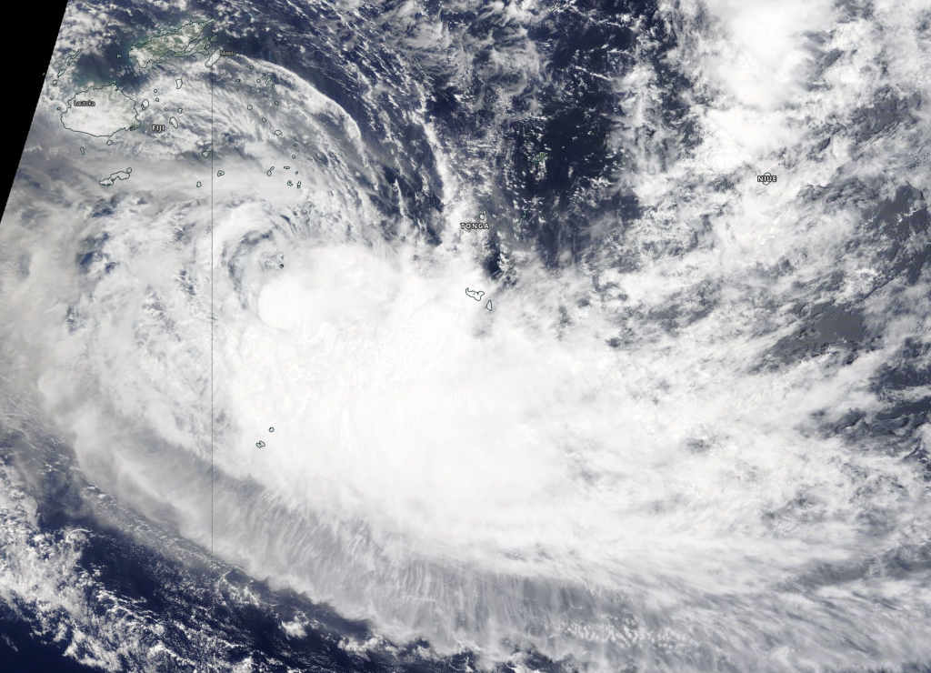
NASA-NOAA’s Suomi NPP satellite provided forecasters with an image of Tropical Cyclone Sarai and it showed a much weaker storm near Tonga in the South Pacific Ocean.

Suomi NPP Image of Sarai
NASA-NOAA’s Suomi NPP satellite provided forecasters with a visible image of Tropical Depression Sarai near the island of Tonga in the South Pacific Ocean. Credit: NASA Worldview, Earth Observing System Data and Information System (EOSDIS)

Visible imagery from NASA satellites help forecasters understand if a storm is organizing or weakening. The Visible Infrared Imaging Radiometer Suite (VIIRS) instrument aboard Suomi NPP provided a visible image of Sarai on Dec. 31.

The shape of a tropical cyclone provides forecasters with an idea of its organization and strength, and NASA-NOAA’s Suomi NPP satellite provided a visible image of Sarai that showed the center of circulation was surrounded by wispy clouds, while the bulk of clouds and showers were pushed to the southeast of the center from outside winds or vertical wind shear. Because the center of circulation was near Tonga, Regional warnings were still in effect for Tonga. A gale warning is in force for Vava’u, Ha’apai, Tongatapu and ‘Eua land areas.

At 4 a.m. EST (0900 UTC), the Joint Typhoon Warning Center issued the final advisory on  Tropical cyclone Sarai as it weakened to a depression. Sarai was centered near latitude 20.3 degrees south and longitude 174.3 degrees west, about 259 miles west-southwest of Niue. The storm is moving to the east-northeast with maximum sustained winds 30 knots  (34.5 mph/55.5 kph).

Sarai is rapidly weakening and is dissipating under adverse atmospheric conditions.

Tropical cyclones and hurricanes are the most powerful weather events on Earth. NASA’s expertise in space and scientific exploration contributes to essential services provided to the American people by other federal agencies, such as hurricane weather forecasting.

By Rob Gutro 
NASA’s Goddard Space Flight Center

Sarai – Southern Pacific Ocean

Dec. 30, 2019 – NASA Tracks Tropical Storm Sarai Moving Away from Fiji

NASA’s Terra satellite passed over the Southern Pacific Ocean on Dec. 30 and found that Tropical Storm Sarai continued to move further away from Fiji and toward Tonga.

Terra image of Sarai
On Dec. 30, 2019, the MODIS instrument that flies aboard NASA’s Terra satellite provided a visible image of Tropical Storm Sarai moving away from Fiji. Credit: NASA Worldview

On Dec. 30, 2019, the Moderate Resolution Imaging Spectroradiometer or MODIS instrument that flies aboard NASA’s Terra satellite provided a visible image of Sarai that showed the storm had flaring convection andthe strongest thunderstorms were around the low-level center. The storm also appeared elongated indicating it was weakening.

On Dec. 30 at 10 a.m. EST (1500 UTC), the Joint Typhoon Warning Center noted that Tropical Cyclone Sarai was located near latitude 22.1 degrees south and longitude 176.4 degrees west, about 403 nautical miles west-southwest of Niue. Maximum sustained winds were 45 knots (52 mph) and weakening.

Sarai is forecast to curve to the northeast and pass just north of Tonga and Niue over the next several days. Both of those islands can expect rough surf, tropical storm force winds and heavy rains. As this storm continues tracking in an easterly direction, the Joint Typhoon Warning Center expects vertical wind shear, or outside winds, to increase leading to a weakening trend.

NASA’s Terra satellite is one in a fleet of NASA satellites that provide data for hurricane research.

Tropical cyclones and hurricanes are the most powerful weather events on Earth. NASA’s expertise in space and scientific exploration contributes to essential services provided to the American people by other federal agencies, such as hurricane weather forecasting.

By Rob Gutro
NASA’s Goddard Space Flight Center

Sarai – Southern Pacific Ocean

Dec. 27, 2019 – NASA Finds Heavy Rain Potential in Tropical Storm Sarai

NASA analyzed the cloud top temperatures in Tropical Storm Sarai using infrared light to determine the strength of the storm. Sarai has triggered warnings for Fiji and Tonga in the Southern Pacific Ocean,

AIRS image of Sarai
On Dec. 27 at 0135 UTC (Dec. 26 at 8:35 p.m. EST) NASA’s Aqua satellite analyzed the using the AIRS instrument. AIRS showed that the strongest storms were located over the Lakshadweep Islands where the coldest cloud top temperatures were as cold as or colder than 210 Kelvin (purple) minus 81 degrees Fahrenheit (minus 63.1 degrees Celsius) around the center. Credit: NASA JPL/Heidar Thrastarson

On Dec. 27, there are regional warnings in effect for Fiji and Tonga. In Fiji, there is a storm warning is in force for Vatulele and Kadavu. A gale warning is in force for Vanua Levu, Taveuni, Yasawa and the Mamanuca Group, Kadavu, Lomaiviti Group, Viti Levu and nearby smaller islands. Tonga is on a tropical cyclone alert.

One of the ways NASA researches tropical cyclones is using infrared data that provides temperature information. Cloud top temperatures identify where the strongest storms are located. The stronger the storms, the higher they extend into the troposphere, and the colder the cloud top temperatures.

On Dec. 27 at 0135 UTC (Dec. 26 at 8:35 p.m. EST) NASA’s Aqua satellite analyzed the storm using the Atmospheric Infrared Sounder or AIRS instrument. The AIRS imagery showed the strongest storms circling the center of circulation, just west of Fiji and in a thick band of thunderstorms northeast of Fiji. In those areas, AIRS found coldest cloud top temperatures as cold as or colder than 210 Kelvin (minus 81 degrees Fahrenheit/minus 63.1 degrees Celsius). NASA research has shown that cloud top temperatures that cold indicate strong storms that have the capability to create heavy rain.

Tropical cyclones do not always have uniform strength, and some sides have stronger sides than others, so knowing where the strongest sides of the storms are located helps forecasters. NASA then provides data to tropical cyclone meteorologists so they can incorporate it in their forecasts.
At 10 a.m. EST (1500 UTC) on Dec.27 the Joint Typhoon Warning Center or JTWC noted that the center of Tropical cyclone Sarai was located near latitude 18.7 degrees south and longitude 176.1 degrees east, about 136 nautical miles west-southwest of Suva, Fiji. Maximum sustained winds were near 55 knots (63 mph/102 kph) and the storm was strengthening. It was moving to the south and expected to turn east.

Sarai is forecast to move toward the east. The storm is expected to strengthen briefly to 65 knots on its closest approach to the main Fijian islands, but weaken as it nears Tonga.

Typhoons and hurricanes are the most powerful weather events on Earth. NASA’s expertise in space and scientific exploration contributes to essential services provided to the American people by other federal agencies, such as hurricane weather forecasting.

The AIRS instrument is one of six instruments flying on board NASA’s Aqua satellite, launched on May 4, 2002.

By Rob Gutro
NASA’s Goddard Space Flight Center  

Sarai – Southern Pacific Ocean

Dec. 26, 2019 – NASA-NOAA Satellite Finds Development of Tropical Cyclone Sarai

Imagery from NASA-NOAA’s Suomi NPP satellite showed that a tropical low-pressure area has consolidated and organized in the Southern Pacific Ocean near Fiji.

Suomi NPP image of Sarai
NASA-NOAA’s Suomi NPP satellite passed over the Southern Pacific Ocean on Dec. 26 and found Tropical Storm Sarai had developed near Fiji. The image showed strong bands of thunderstorms from the western quadrant wrapping into the low-level center of circulation. Credit: NASA Worldview, Earth Observing System Data and Information System (EOSDIS)

Tropical Storm Sarai has formed to the west of Fiji. Fiji is an archipelago, consisting of more than 300 islands in the South Pacific Ocean.

On Dec. 26 at 6:43 a.m. EST) Dec. 27 at 12:43 a.m. Fiji local time, the Fiji Meteorological Service has issued various warnings for Fiji and surrounding islands. A gale warning remains in force for Rotuma, Vanua Levu, Taveuni and nearby smaller islands, Yasawa and Mamanuca Group, Kadavu, Lomaiviti group, Viti Levu and nearby smaller islands. A strong wind warning remains in force for the rest of Fiji. A heavy rain warning remains in force for the Fiji group.

The Visible Infrared Imaging Radiometer Suite (VIIRS) instrument aboard Suomi NPP provided a visible image of Sarai that revealed a band of thunderstorms were wrapping into the low-level center of circulation.

At 4 a.m. EST (0900 UTC) on Dec. 26, the Joint Typhoon Warning Center or JTWC in Pearl Harbor, Hawaii noted that Sarai had maximum sustained winds near 35 knots (40 mph/65 kph). Sarai was located near latitude 13.7 degrees south and longitude 176.2 degrees east, approximately 320 nautical miles north-northwest of Suva, Fiji. The tropical cyclone has tracked south southeastward. The tropical storm’s center is expected to stay over water, just southwest of Fiji. JTWC said, “The favorable environment will allow steady ‘intensification to 65 knots as it passes Nadi.”

Tropical cyclones and hurricanes are the most powerful weather events on Earth. NASA’s expertise in space and scientific exploration contributes to essential services provided to the American people by other federal agencies, such as hurricane weather forecasting.

For updated forecasts from the Fiji Meteorological Service, visit: http://www.met.gov.fj/

By Rob Gutro 
NASA’s Goddard Space Flight Center