Dalila (was TD5E) – Eastern Pacific Ocean

July 25, 2019 – NASA Finds One Burst of Energy in Weakening Depression Dalila

Infrared imagery from NASA’s Aqua satellite found just a small area of cold clouds in thunderstorms within weakening Tropical Depression Dalila, enough to maintain it as a tropical cyclone.

Aqua image of Dalila
On July 25 at 5:20 a.m. EDT (0920 UTC), the MODIS instrument that flies aboard NASA’s Aqua satellite showed strongest storms in Dalila were in a small area north of the center. There cloud top temperatures were as cold as minus 50 degrees Fahrenheit (minus 45.5 Celsius). Credit: NASA/NRL

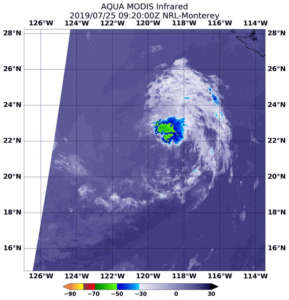
NASA’s Aqua satellite uses infrared light to analyze the strength of storms by providing temperature information about the system’s clouds. The strongest thunderstorms that reach high into the atmosphere have the coldest cloud top temperatures.

On July 25 at 5:20 a.m. EDT (0920 UTC), the Moderate Imaging Spectroradiometer or MODIS instrument that flies aboard NASA’s Aqua satellite gathered infrared data on Dalila. There was still a small area of strong thunderstorms with cloud top temperatures as cold as minus 50 degrees Fahrenheit (minus 45.5 Celsius). The National Hurricane Center or NHC noted, “Dalila is still technically a tropical cyclone based on the development of new convection within 70-75 nautical miles northeast of the center.” That thunderstorm development was enough to maintain its classification as a tropical cyclone.

The NHC said, “At 5 a.m. EDT (0900 UTC), the center of Tropical Depression Dalila was located near latitude 21.6 degrees north and longitude 120.4 degrees west. That’s about 675 miles (1,090 km) west of the southern tip of Baja California, Mexico. The depression is moving toward the northwest near 6 mph (9 kph) and this motion is expected to continue this morning. The estimated minimum central pressure is 1009 millibars. Maximum sustained winds remain near 30 mph (45 kph) with higher gusts.

Weakening is forecast during the next couple of days, and Dalila is expected to become a post-tropical remnant low later today.

For updated forecasts, visit: https://www.nhc.noaa.gov

By Rob Gutro
NASA’s Goddard Space Flight Center


Dalila (was TD5E) – Eastern Pacific Ocean

July 24, 2019 – Suomi NPP Satellite Sees Tropical Depression Dalila Fading

NASA-NOAA’s Suomi NPP satellite provided a visible image of weakening Tropical Depression Dalila in the Eastern Pacific Ocean.

Suomi NPP image of Dalila
NASA-NOAA’s Suomi NPP satellite passed over the Eastern Pacific Ocean and captured an infrared view of Tropical Depression Dalila. Suomi NPP saw a limited area of strong thunderstorms where cloud top temperatures were as cold as minus 70 degrees Fahrenheit (minus 56.6 Celsius). Credit: NASA/NRL

Suomi NPP passed over Dalila on July 24 and the Visible Infrared Imaging Radiometer Suite (VIIRS) instrument provided a visible image of the storm. The VIIRS image showed that strong convection and developing thunderstorms associated with the cyclone has continued to decrease in coverage this morning. Suomi NPP saw a limited area of strong thunderstorms where cloud top temperatures were as cold as minus 70 degrees Fahrenheit (minus 56.6 Celsius).  The National Hurricane Center said that there is still a broken band of convection over the southeastern portion of the circulation.

At 11 a.m. EDT (1500 UTC) on July 24, the National Hurricane Center or NHC said the center of Tropical Depression Dalila was located near latitude 20.5 degrees north and longitude 119.0 degrees west. That’s about 605 miles (975 km) west-southwest of the southern tip of Baja California, Mexico. The depression is moving toward the northwest near 7 mph (11 kph), and this motion is expected to continue today.  A turn toward the west-northwest is forecast to occur by Thursday, and that general motion should continue until the system dissipates in a few days. Maximum sustained winds are near 35 mph (55 kph) with higher gusts.

The NHC noted that Dalila will be moving into an area where sea surface temperatures are too cold to maintain the tropical cyclone and into a dry and more stable airmass.  NHC said, “This should result in weakening, and the system is expected to degenerate into a remnant low within 24 hours.”

Weakening is forecast during the next couple of days, and Dalila is expected to become a post-tropical remnant low tonight.

By Rob Gutro 
NASA’s Goddard Space Flight Center

Dalila (was TD5E) – Eastern Pacific

July 23, 2019 – NASA Finds Depression Strengthen into Tropical Storm Dalila

Satellite imagery on July 22 showed that wind shear was preventing the Eastern Pacific Ocean’s Tropical Depression 5 from consolidating and strengthening. Infrared imagery from NASA’s Aqua satellite on July 23 showed that the wind shear eased and the storm was able to strengthen.

Aqua image of Dalila
On July 23 at 5:35 a.m. EDT (0935 UTC), the MODIS instrument that flies aboard NASA’s Aqua satellite showed strongest storms (yellow) in Tropical Storm Dalila had cloud top temperatures as cold as minus 80 degrees Fahrenheit (minus 62.2 Celsius). Credit: NASA/NRL

NASA’s Aqua satellite used infrared light to analyze the strength of storms circled the center of circulation, a change from 24 hours before when wind shear pushed them away from the center. Now, the storm appears much more circular.

Infrared data provides temperature information, and the strongest thunderstorms that reach high into the atmosphere have the coldest cloud top temperatures.

On July 23 at 5:35 a.m. EDT (0935 UTC), the Moderate Imaging Spectroradiometer or MODIS instrument that flies aboard NASA’s Aqua satellite gathered infrared data on the strengthened Tropical Storm Dalila. Strongest thunderstorms had cloud top temperatures as cold as minus 80 degrees Fahrenheit (minus 62.2 Celsius). Cloud top temperatures that cold indicate strong storms with the potential to generate heavy rainfall.

At 5 a.m. EDT (0900 UTC) on July 23, the National Hurricane Center (NHC) the center of newly formed Tropical Storm Dalila was located near latitude 18.0 degrees north and longitude 117.3 degrees west. That is about 585 miles (945) km) southwest of the southern tip of Baja California, Mexico. There are no coastal watches or warnings in effect.

Maximum sustained winds have increased to near 40 mph (65 kph) with higher gusts.  The estimated minimum central pressure is 1005 millibars. Dalila is moving toward the north-northwest near 7 mph (11 kph). A turn to the northwest is anticipated on Wednesday, followed by a movement more to the west-northwest on Thursday and Friday.

NHC noted, “Some weakening is forecast to begin on Wednesday, and Dalila could degenerate into a remnant low on Thursday.”

For updated forecasts, visit: https://www.nhc.noaa.gov

By Rob Gutro
NASA’s Goddard Space Flight Center

TD5E (Eastern Pacific)

July 22, 2019 – NASA Sees Outside Winds Affecting New Tropical Eastern Pacific Depression

A new tropical depression formed in the Eastern Pacific Ocean, far enough away from the coast so that no coastal warnings are needed. Infrared imagery from NASA’s Aqua satellite shows that Tropical Depression 5E’s strongest storms were southwest of its center of circulation because of outside winds.

Aqua image of TD5E
On July 22 at 4:50 a.m. EDT (0850 UTC) the MODIS instrument that flies aboard NASA’s Aqua satellite showed strongest storms in Tropical Depression 5# were south of the elongated center where cloud top temperatures were as cold as minus 70 degrees Fahrenheit (red) (minus 56.6 Celsius). Credit: NASA/NRL

NASA’s Aqua satellite used infrared light to analyze the strength of storms and found the bulk of them in the southern quadrant. Infrared data provides temperature information, and the strongest thunderstorms that reach high into the atmosphere have the coldest cloud top temperatures.

On July 22 at 4:50 a.m. EDT (0850 UTC), the Moderate Imaging Spectroradiometer or MODIS instrument that flies aboard NASA’s Aqua satellite gathered infrared data on Tropical Depression 5E. Strongest thunderstorms had cloud top temperatures as cold as minus 70 degrees Fahrenheit (minus 56.6 Celsius). Cloud top temperatures that cold indicate strong storms with the potential to generate heavy rainfall. Those strongest storms were southwest of the center of circulation because of vertical wind shear (winds blowing at different speeds at different levels of the atmosphere).  The National Hurricane Center noted, “It appears that northeasterly shear is keeping much of the convection displaced to the west of the center of circulation.”

At 11 a.m. EDT (1500 UTC) on July 22, the National Hurricane Center (NHC) said the center of Tropical Depression Five-E was located near latitude 15.9 degrees North and longitude 116.3 degrees west. That’s about 640 miles (1.025 km) southwest of the southern tip of Baja California, Mexico.

The depression is moving toward the north near 9 mph (15 kph) and this motion is expected to continue for the next day or so, with a gradual turn to the northwest by midweek. Maximum sustained winds are near 35 mph (55 kph) with higher gusts. The estimated minimum central pressure is 1006 millibars.

NHC noted “Although convection [and thunderstorm development] has increased this morning, ] the [wind[shear is preventing the inner core of the depression from becoming better established.” Some slight strengthening is possible over the next couple of days, and the depression is expected to become a tropical storm later today or tonight.

For updated forecasts, visit: https://www.nhc.noaa.gov

By Rob Gutro
NASA’s Goddard Space Flight Center