Oct. 01, 2018 – NASA’s Infrared Vision Reveals Rosa’s Extent into the U.S. Southwest
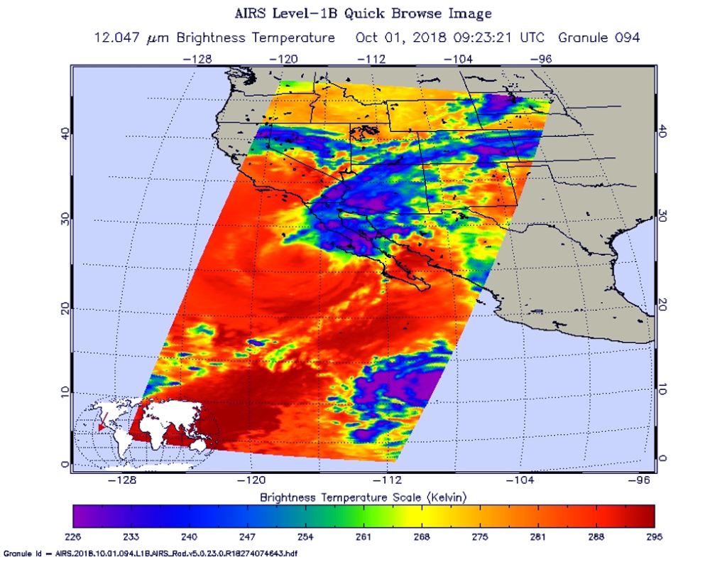
Hurricane Rosa continued weakening as NASA’s Aqua satellite passed overhead and collected temperature information. Satellite data showed that Rosa’s center still off-shore from northwestern Mexico, but its clouds and rains had already stretched into Arizona and infrared data showed that rainfall potential.
National Hurricane Center (NHC) said a Tropical Storm Warning is in effect for the west coast of the Baja California peninsula from Punta Abreojos to Cabo San Quintin. A Tropical Storm Watch is in effect for the east coast of the Baja California peninsula from Bahia de los Angeles to San Felipe. Interests elsewhere in the northern and central Baja California peninsula and northwestern Sonora should monitor the progress of Rosa.
The Atmospheric Infrared Sounder or AIRS instrument aboard NASA’s Aqua satellite passed over Tropical Storm Rosa on Oct. 1 at 5:23 a.m. EDT (0923 UTC). and analyzed the storm in infrared light. Infrared light provides temperature data and that’s important when trying to understand how strong storms can be. The higher the cloud tops, the colder and the stronger they are.
When Aqua passed over Rosa, the AIRS instrument found coldest cloud top temperatures in thunderstorms mostly northeast the center where temperatures were as cold as minus 63 degrees Fahrenheit (minus 53 degrees Celsius). Those storms were stretching over northwestern Mexico and into Arizona. Storms with cloud top temperatures that cold have the capability to produce heavy rainfall.
At 11 a.m. EDT (1500 UTC), NHC noted the center of Tropical Storm Rosa was located near latitude 27.5 degrees west and longitude 116.5 degrees west. That’s 90 miles (140 km) west-southwest of Punta Eugenia, Mexico. Rosa is moving toward the north-northeast near 12 mph (19 km/h), and this general motion is expected to continue through Tuesday, Oct. 2. Maximum sustained winds are near 45 mph (75 kph) with higher gusts. Some weakening is forecast during the next 48 hours. Weakening is forecast through tonight while Rosa approaches and moves over the northern Baja California peninsula.
On the forecast track, the center of Rosa will approach the central and northern Baja California peninsula later today, Oct. 1 and then move across the peninsula into the northern Gulf of California tonight. Rosa’s remnants are then expected to move across the Desert Southwest on Tuesday, Oct. 2. Rosa is expected to become a remnant low over the southwestern United States on Tuesday.
For updated forecasts on Rosa, visit: www.nhc.noaa.gov.
For local forecasts and impacts in the U.S., visit: www.weather.gov.
By Rob Gutro
NASA’s Goddard Space Flight Center