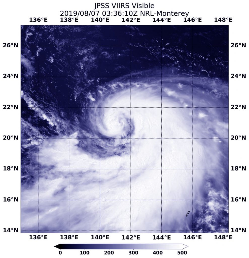
Aug. 07, 2019 – Tropical Storm Krosa Gets a Comma Shape
Tropical Storm Krosa continued on its journey northward in the Northwestern Pacific Ocean when NOAA’s NOAA-20 polar orbiting satellite passed overhead and captured a visible image of the strengthening storm in a classic tropical cyclone shape.
NOAA’s NOAA-20 polar orbiting satellite passed over the Northwestern Pacific Ocean and captured a visible image of Tropical Storm Krosa on Aug. 7, 2019. Credit: NASA/NRL/NOAA
The Visible Infrared Imaging Radiometer Suite (VIIRS) instrument aboard NOAA-20 provided a visible image of the storm. There’s also a VIIRS instrument aboard the NASA-NOAA Suomi NPP satellite that preceded NOAA-20.
The VIIRS image revealed Krosa had developed the signature “comma shape” of a strengthening storm. A large wide band of thunderstorms were feeding into the low-level center from the south and east of the center.
At 5 a.m. EDT (0900 UTC) on Aug. 7, Tropical Storm Krosa’s maximum sustained winds were near 60 knots (69 mph/111 kph) and strengthening. It was centered near 21.2 degrees north latitude and 141.3 degrees east longitude. That is about 31 nautical miles south of Iwo To island, Japan. Krosa was moving to the north-northwest.
The Joint Typhoon Warning Center said that Krosa will move northwest, and then later turn north while becoming a typhoon.
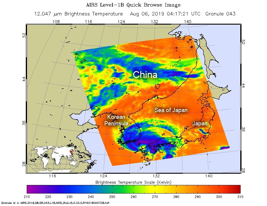
Aug. 06, 2019 – NASA Finds Tropical Storm Francisco in the Korea Strait
NASA’s Aqua satellite passed over the Korea Strait and found the center of Tropical Storm Francisco in the middle of it. The AIRS instrument aboard took the temperature of its cloud tops to estimate storm strength and found strong storms over two countries.
On Aug. 6, at 1217 a.m. EDT (0417 UTC). the AIRS instrument aboard NASA’s Aqua satellite analyzed cloud top temperatures of Tropical Storm Francisco in infrared light. AIRS found coldest cloud top temperatures (purple) of strongest thunderstorms were as cold as or colder than minus 63 degrees Fahrenheit (minus 53 degrees Celsius). Credit: NASA JPL/Heidar Thrastarson
The Korea Strait is a located between South Korea and Japan. It connects the East China Sea, the Yellow Sea and the Sea of Japan in the northwest Pacific Ocean.
NASA’s Aqua satellite passed over Francisco on Aug. 6, at 1217 a.m. EDT (0417 UTC). The Atmospheric Infrared Sounder or AIRS instrument aboard NASA’s Aqua satellite analyzed Francisco in infrared light and found cloud top temperatures of strongest thunderstorms as cold as or colder than minus 63 degrees Fahrenheit (minus 53 degrees Celsius) were wrapping around the low-level center from west to north to east. Cloud top temperatures that cold indicate strong storms that have the capability to create heavy rain. Those strong storms were affecting southern South Korea and southern Japan. The southern side of the storm appeared to have few storms.
At 11 a.m. EDT (1500 UTC), the center of Tropical Storm Francisco was located near latitude 36.2 degrees north and 129.4 degrees east longitude. Francisco’s center is about 33 nautical miles north-northeast of Busan, South Korea. It was moving to the northwest and had maximum sustained winds near 45 knots (52 mph/83 kph).
The Joint Typhoon Warning Center forecasts that Francisco will move north then turn northeast and curve east through the Sea of Japan and cross Hokkiado, the northernmost islands of Japan on Aug. 8.
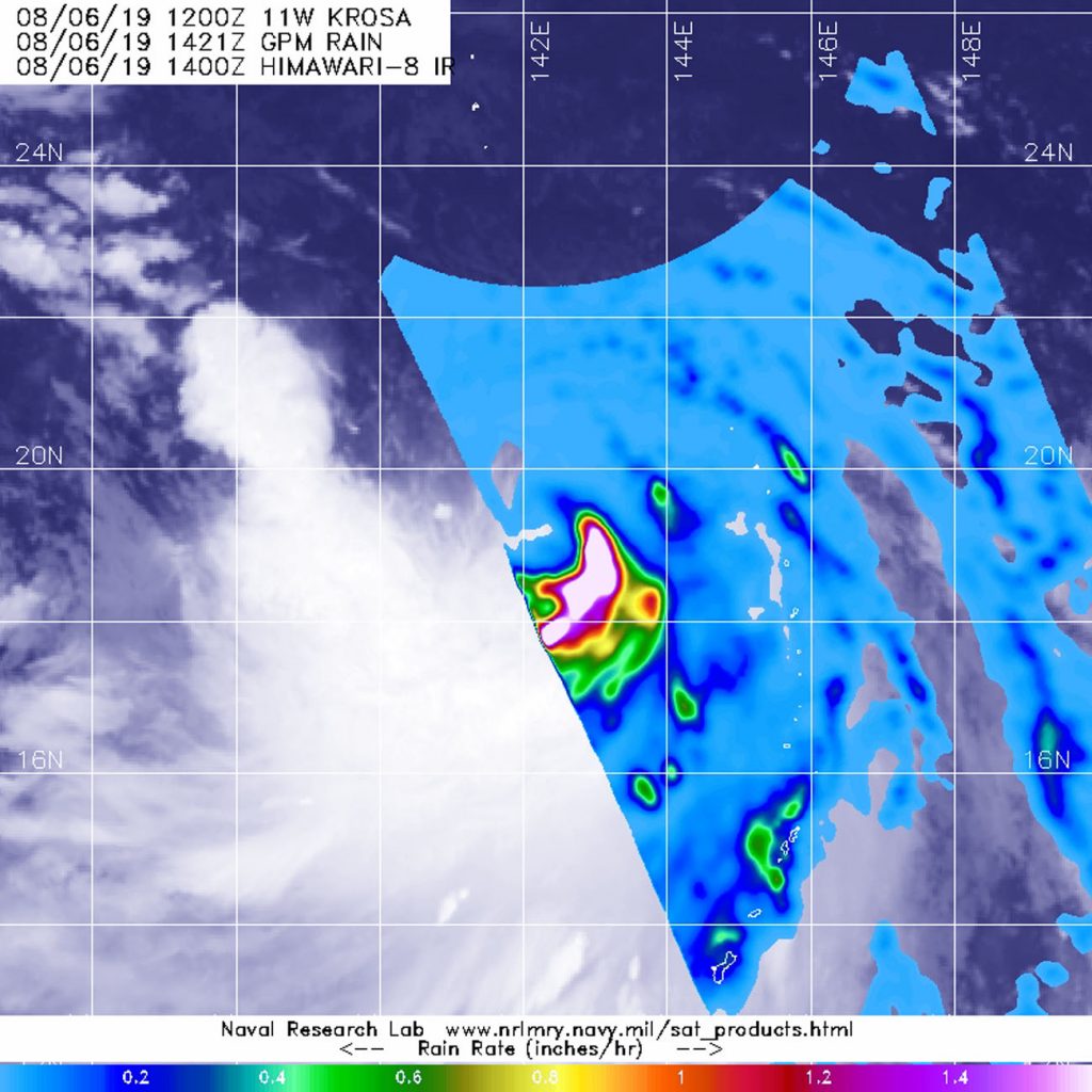
Aug. 06, 2019 – NASA Finds Heavy Rain in New Tropical Storm Krosa
Tropical Storm Krosa had recently developed into a tropical storm when the GPM satellite passed overhead and found heavy rainfall. Fortunately, the storm was over open waters.
The GPM core satellite passed over Tropical Storm Krosa at 10:21 a.m. EDT (1421 UTC) on August 6, 2019. GPM found the heaviest rainfall (pink) was east of the center of circulation falling at a rate of 50 mm (about 2 inches) per hour. Credit: NASA/JAXA/NRL
Krosa formed on August 5 as the eleventh tropical depression of the Northwestern Pacific Ocean typhoon season. On August 6 by 5 a.m. EDT (0900 UTC) it had become a tropical storm and was re-named Krosa.
The Global Precipitation Measurement mission or GPM core satellite passed over Tropical Storm Krosa at 10:21 a.m. EDT (1421 UTC) on August 6, 2019. GPM found the heaviest rainfall was east of the center of circulation falling at a rate of 50 mm (about 2 inches) per hour, over open ocean GPM is a joint mission between NASA and the Japan Aerospace Exploration Agency, JAXA.
At 11 a.m. EDT (1500 UTC) Tropical storm Krosa was located near19.0 degrees north latitude and 142.3 east longitude, about 352 miles south of Iwo To Island, Japan. Krosa was moving to the northwest and had maximum sustained winds near 40 knots (46 mph/74 kph).
The Joint Typhoon Warning Center noted that Krosa will move northwest, then later north and strengthen to a typhoon with maximum sustained winds near 75 knots (86 mph/139 kph).
Krosa is expected to pass very near the island of Iwo To on August 9 and move north.
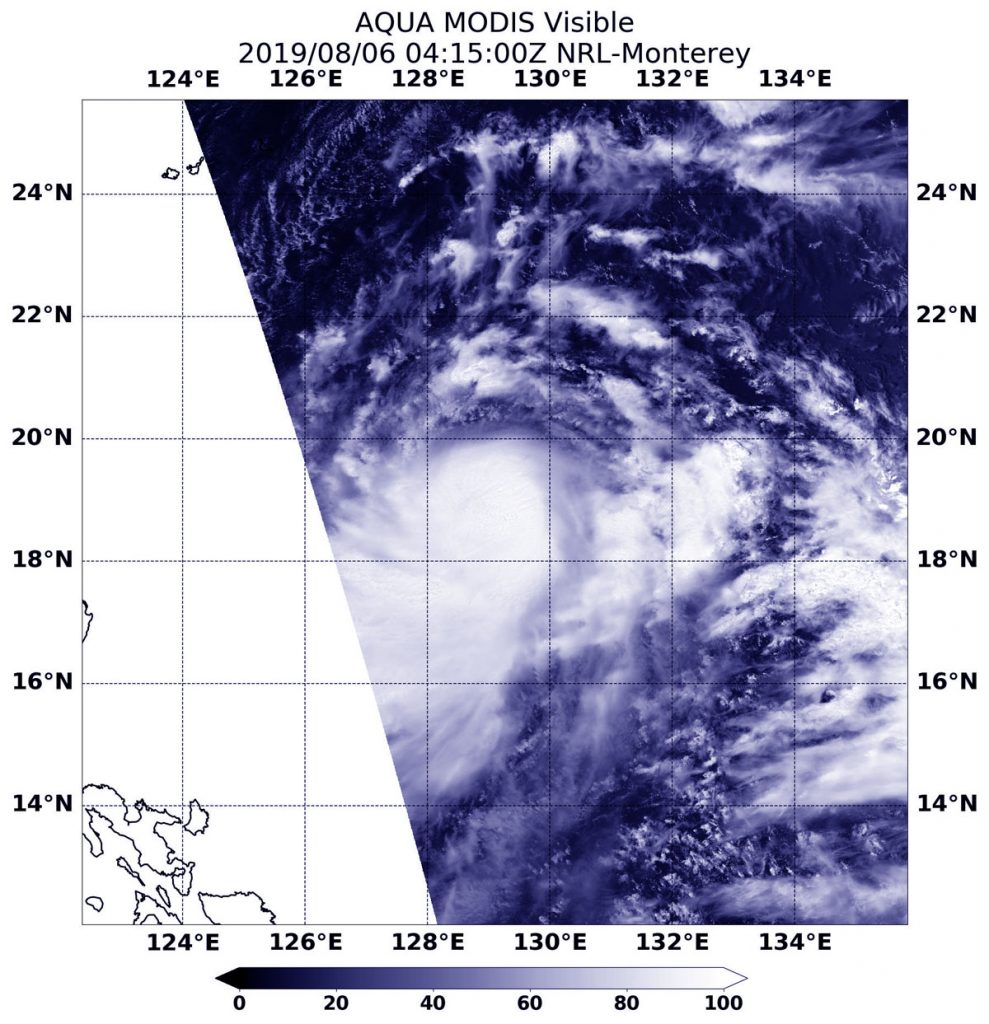
Aug. 06, 2019 – NASA Satellite Finds Strong Storms Circling Lekima’s Center
NASA’s Aqua satellite passed over the Northwestern Pacific Ocean and captured a visible image of strengthening Tropical Storm Lekima.
On Aug. 6, 2019, the MODIS instrument aboard NASA’s Aqua satellite provided a visible image of Tropical Storm Lekima in the Northwestern Pacific Ocean. Credit: NASA/NRL
On Aug. 6, the Moderate Resolution Imaging Spectroradiometer or MODIS instrument aboard NASA’s Aqua satellite provided a visible image of Lekima that showed a ring of strong thunderstorms around its center of circulation.
At 5 a.m. EDT (0900 UTC), the center of Lekima was located near latitude 19.1 degrees north and longitude 129.0 degrees east. Lekima was about 449 nautical miles south of Kadena Air Base, Okinawa, Japan. Lekima was moving to the north-northwest and had maximum sustained winds near 50 knots (57 mph/92 kph).
The Joint Typhoon Warning Center expects Lekima to move northwest and strengthen into a typhoon. After 3 days, it will pass over Taiwan and turn northeast just off the east coast of China, where it is expected to dissipate.
Aug. 06, 2019 – NASA Sees Flossie Now a Remnant Low Pressure Area
Former Hurricane Flossie was nothing more than a remnant low pressure area early on Tuesday, August 6. Infrared imagery from NASA’s Aqua satellite found just a few scattered areas of cold clouds in thunderstorms in the remnants northeast of the Hawaiian Islands.
On August 6 at 4:40 a.m. EDT (0840 UTC), the MODIS instrument that flies aboard NASA’s Aqua satellite showed strongest thunderstorms in the remnants of Flossie were fragmented northeast of the Hawaiian Islands. There cloud top temperatures were as cold as minus 50 degrees Fahrenheit (minus 45.5 Celsius). Credit: NASA/NRL
NASA’s Aqua satellite uses infrared light to analyze the strength of storms by providing temperature information about the system’s clouds. The strongest thunderstorms that reach high into the atmosphere have the coldest cloud top temperatures.
On August 6 at 4:40 a.m. EDT (0840 UTC), the Moderate Imaging Spectroradiometer or MODIS instrument that flies aboard NASA’s Aqua satellite gathered infrared data on Flossie.
MODIS found just a few scattered areas of cold clouds in thunderstorms in the remnants, northeast of the Hawaiian Islands. Those thunderstorms had cloud top temperatures as cold as minus 50 degrees Fahrenheit (minus 45.5 Celsius).
The NHC issued the final advisory on Flossie at 11 p.m. EDT on Aug. 5 (0300 UTC on Aug. 6). At that time, center of Post-Tropical Cyclone Flossie was located near latitude 20.8 degrees North and longitude 154.6 degrees West. That’s about 85 miles (135 km) north-northeast of Hilo, Hawaii. The post-tropical cyclone is moving toward the west-northwest near 12 mph (19 kph). A gradual turn toward the north-northwest is expected until dissipation on Wednesday.
Maximum sustained winds are near 35 mph (55 kph) with higher gusts.
Flossie is expected to gradually degenerate over the next day or so and dissipate by Wednesday.
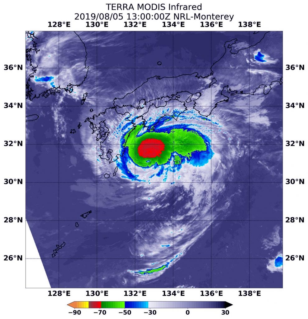
Aug. 05, 2019 – NASA Catches Tropical Storm Francisco’s Approach to Landfall in Southern Japan
Infrared imagery from NASA’s Aqua satellite shows that Tropical Storm Francisco had powerful thunderstorms with heavy rain capabilities around the center of circulation as it moves toward landfall in southern Japan.
On Aug. 5 at 9 a.m. EDT (1300 UTC) the MODIS instrument that flies aboard NASA’s Aqua satellite showed strongest storms (red) in Tropical Storm Francisco circled the center. There, cloud top temperatures were as cold as minus 70 degrees Fahrenheit (minus 56.6 Celsius). Credit: NASA/NRL
On Aug. 5, 2019, the Japan Meteorological Agency has issued warnings for the Amami, Kyushu and Shikoku. Advisories are in effect for Chugoku, Kinki Ogasawara, Okinawa and Tokai.
NASA’s Aqua satellite used infrared light to analyze the strength of storms in Tropical Storm Francisco and found strongest storms circling the center. Infrared data provides temperature information, and the strongest thunderstorms that reach high into the atmosphere have the coldest cloud top temperatures.
On Aug. 5 at 9 a.m. EDT (1300 UTC), the Moderate Imaging Spectroradiometer or MODIS instrument that flies aboard NASA’s Aqua satellite found strongest thunderstorms had cloud top temperatures as cold as minus 70 degrees Fahrenheit (minus 56.6 Celsius). Cloud top temperatures that cold indicate strong storms with the potential to generate heavy rainfall.
Microwave satellite imagery revealed an eye had formed in the center of those powerful thunderstorms.
The Joint Typhoon Warning Center or JTWC noted at 11 a.m. EDT (1500 UTC) that Francisco had maximum sustained winds near 60 knots (60 mph/111kph). Francisco was centered near 31.6 degrees north latitude and 132.4 degrees east longitude. Tropical storm Francisco was located approximately 203 nautical miles east-southeast of Sasebo, Japan. Francisco has tracked westward.
After the storm makes landfall in Kyushu, Japan, it is forecast to pass into the south of the Korean peninsula, and turn to the northeast as it becomes extra-tropical over the Sea of Japan.
For updated warnings from the Japan Meteorological Agency, visit: https://www.jma.go.jp/en/warn/
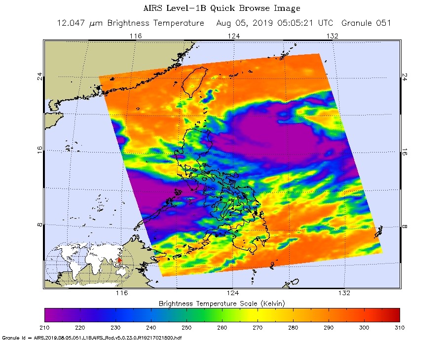
Aug. 05, 2019 – NASA Gazes into Tropical Storm Lekima in Philippine Sea
NASA’s Aqua satellite gazed into Tropical Storm Lekima as it moved through the Philippine Sea on August 5 and the AIRS instrument aboard took the temperature of its cloud tops to estimate storm strength.
On Aug. 5, at 0105 a.m. EDT (0505 UTC) the AIRS instrument aboard NASA’s Aqua satellite analyzed cloud top temperatures of Tropical Storm Lekima in infrared light. AIRS found coldest cloud top temperatures (purple) of strongest thunderstorms were as cold as or colder than minus 63 degrees Fahrenheit (minus 53 degrees Celsius). Credit: NASA JPL/Heidar Thrastarson
Lekima formed early on Aug. 4 as Tropical Depression 10W and strengthened into a tropical storm on Aug. 5, when it was renamed Lekima.
NASA’s Aqua satellite passed over Lekima on Aug. 5, at 0105 a.m. EDT (0505 UTC). The Atmospheric Infrared Sounder or AIRS instrument aboard NASA’s Aqua satellite analyzed Lekima in infrared light and found cloud top temperatures of strongest thunderstorms as cold as or colder than minus 63 degrees Fahrenheit (minus 53 degrees Celsius) were wrapping into the low-level center from the south. Cloud top temperatures that cold indicate strong storms that have the capability to create heavy rain.
Strongest storms extend high into the troposphere and have very cold cloud top temperatures as cold as or colder than minus 63 degrees Fahrenheit (minus 53 degrees Celsius).
At 5 a.m. EDT (0900 UTC), the center of Tropical Storm Lekima was located near latitude 19.2 degrees north and 129.5 degrees east longitude. Lekima’s center is about 456 nautical miles south-southeast of Kadena Air Base, Okinawa Island, Japan. It was moving to the northwest and had maximum sustained winds near 35 knots (40 mph/64 kph). In the Philippines, Lekima is called Hanna.
The Joint Typhoon Warning Center forecasts that Lekima will move northwest and make landfall over northern Taiwan on Aug. 9, then make a final landfall in mainland China.
Aug. 05, 2019 – Short-Lived Tropical Storm Gil Gives a Kick on NASA Imagery
Tropical Storm Gil was a two day tropical cyclone in the Eastern Pacific Ocean. It formed on Saturday, August 3, and by the end of the day on August 4, it was already a remnant low pressure area. On August 5, though, NASA’s Terra satellite found a couple of small areas of strong storms left in the remnants of Gil.
On Aug. 5 at 2:20 a.m. EDT (0620 UTC), the MODIS instrument that flies aboard NASA’s Terra satellite showed a couple of small area of strong storms remaining (yellow) in the remnants of Tropical Storm Gil. Cloud top temperatures in those areas were as cold as minus 50 degrees Fahrenheit (minus 45.5 Celsius). Credit: NASA/NRL
Tropical Depression 8E formed on Aug. 3 around 11 a.m. EDT, about 930 miles (1,495 km) southwest of the southernmost tip of Baja California, Mexico. By 5 p.m. EDT, it strengthened into a tropical storm and was re-named Gil. Gil peaked 6 hours later when maximum sustained winds reached 40 mph (65 kph). It weakened quickly after that time.
It was just the next day, that NOAA’s National Hurricane Center (NHC) noted that Gil had degenerated into a remnant low pressure area. At that time, Gil was located about 1,255 miles (2,020 km) southwest of the southern tip of Baja California.
NASA’s Terra satellite uses infrared light to analyze the strength of storms by providing temperature information about the system’s clouds. The strongest thunderstorms that reach high into the atmosphere have the coldest cloud top temperatures.
On Aug. 5 at 2:20 a.m. EDT (0620 UTC), the Moderate Imaging Spectroradiometer or MODIS instrument that flies aboard NASA’s Terra satellite gathered infrared data on Gil’s remnants. There were a couple of small areas of strong storms where thunderstorms had cloud top temperatures as cold as minus 50 degrees Fahrenheit (minus 45.5 Celsius), but Gil is not expected to regenerate.
Aug. 05, 2019 – NASA Finds One Small Area of Strong Storms Left in Fading Flossie
NASA’s Terra satellite found one small area of strong storms left in Tropical Depression Flossie on August 5 as it neared Hawaii.
On Aug. 5 at 4 a.m. EDT (0800 UTC), the MODIS instrument that flies aboard NASA’s Terra satellite showed one small area of strong storms remaining (yellow) in Tropical Depression Flossie northeast of the center. Cloud top temperatures in those areas were as cold as minus 50 degrees Fahrenheit (minus 45.5 Celsius). Credit: NASA/NRL
Although Flossie is not expected to make landfall, its center will stay over the Central Pacific and pass close enough to the Hawaiian Island chain to bring ocean swells and rainfall. NOAA’s National Hurricane Center (NHC) said, “Swells generated by Flossie will continue to affect portions of the main Hawaiian Islands during the next day or two, producing dangerous surf conditions along east and southeast facing shores.”
In addition, moisture associated with Flossie will spread over portions of the main Hawaiian Islands on Monday, bringing the potential for heavy rainfall. Total rainfall amounts of 1 to 4 inches are expected, with localized higher amounts.
NASA’s Terra satellite uses infrared light to analyze the strength of storms by providing temperature information about the system’s clouds. The strongest thunderstorms that reach high into the atmosphere have the coldest cloud top temperatures.
On Aug. 5 at 4 a.m. EDT (0800 UTC), the Moderate Imaging Spectroradiometer or MODIS instrument that flies aboard NASA’s Terra satellite gathered infrared data on Flossie, now weakened to a depression. The one small area of strong storms was northeast of the center where thunderstorms had cloud top temperatures as cold as minus 50 degrees Fahrenheit (minus 45.5 Celsius).
At 5 a.m. EDT (0900 UTC), the center of Tropical Depression Flossie was located near latitude 19.4 degrees north and longitude 151.3 degrees west. The depression is moving toward the west-northwest near 15 mph (24 kph). Maximum sustained winds are near 35 mph (55 kph) with higher gusts. The estimated minimum central pressure is 1009 millibars.
NHC said, “Weakening is forecast during the next couple days, with Flossie becoming a post-tropical remnant low Monday or Monday night, and dissipating on Tuesday, August 6.”
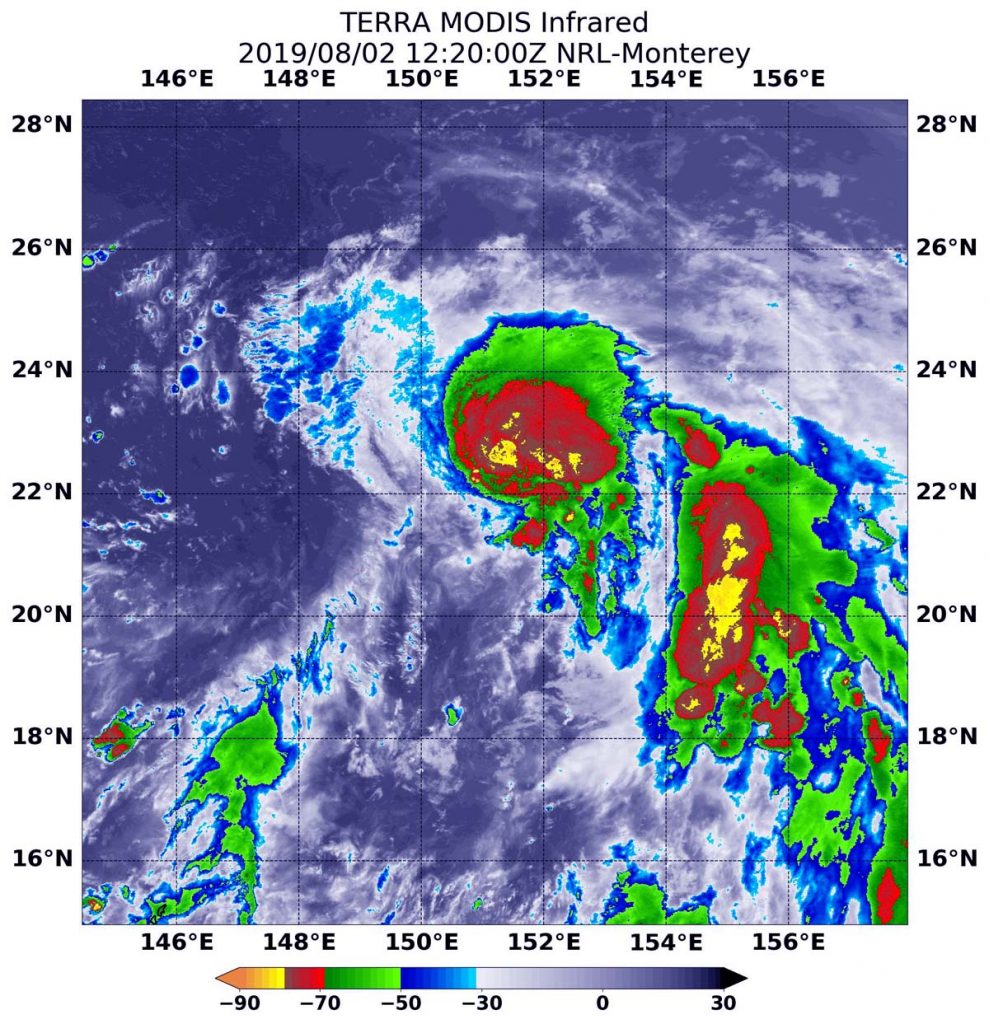
Aug. 02, 2019 – NASA Catches Birth of Northwestern Pacific’s Tropical Storm Francisco
Soon after Tropical Storm Francisco developed in the Northwestern Pacific Ocean NASA’s Terra satellite passed overhead.
On August 2 at 8:20 a.m. EDT (1220 UTC) the MODIS instrument that flies aboard NASA’s Terra satellite showed strongest storms (yellow) in Tropical Storm Francisco around the center and in fragmented bands of thunderstorms circling the center, where cloud top temperatures were as cold as minus 80 degrees Fahrenheit (minus 62.2 Celsius). Credit: NASA/NRL
NASA’s Terra satellite used infrared light to gather temperature information from newly developed Tropical Storm Francisco. The strongest thunderstorms reach high into the atmosphere and have the coldest cloud top temperatures.
On August 2 at 8:20 a.m. EDT (1220 UTC) the Moderate Imaging Spectroradiometer or MODIS instrument that flies aboard NASA’s Terra satellite found coldest cloud top temperatures as cold as minus 80 degrees Fahrenheit (minus 62.2 Celsius). Cloud top temperatures that cold indicate strong storms with the potential to generate heavy rainfall. Those strongest storms were seen around the center and in fragmented bands of thunderstorms circling the center. Those temperatures were also found in a large band of thunderstorms feeding into the center from the east.
At 11 a.m. EDT (1500 UTC), the center of Tropical Storm Francisco was located near latitude 21.7 degrees north and longitude 151.2 degrees east. That’s about 576 nautical miles east-southeast of Iwo To island, Japan. Francisco is moving toward the northwest. Maximum sustained winds are near 40 knots (46 mph/74 kph) with higher gusts.
On the forecast track, the Joint Typhoon Warning Center forecasts Francisco to move northwest toward southwestern Japan. Francisco is expected to strengthen to 85 knots (98 mph/157 kph) before landfall in Kyushu by August 6, and a second landfall the next day in South Korea.