Krosa – Northwestern Pacific Ocean

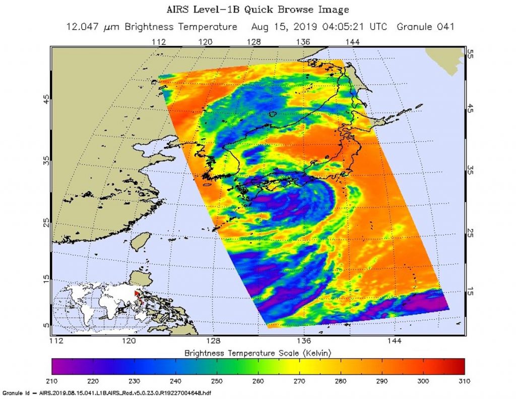
Aug. 16, 2019 – Satellite View of Tropical Storm Krosa Transition in Sea of Japan

Tropical Storm Krosa continued to erode after it moved into the Sea of Japan and satellite data showed it as a ragged and shapeless storm on August 16, 2019.

NOAA-20 image of Krosa
NOAA’s NOAA-20 satellite provided a look at Tropical Storm Krosa as it was becoming extra-tropical in the Sea of Japan on Aug 16 at 12:12 a.m. EDT (0412 UTC). Credit: NOAA/NRL

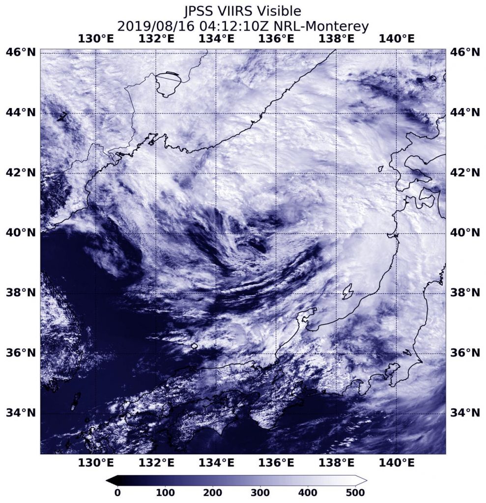
The center of Tropical Storm Krosa’s circulation was difficult to pinpoint in the Aug. 16 visible image from the Visible Infrared Imaging Radiometer Suite (VIIRS) instrument aboard the NOAA-20 satellite. NOAA-20 passed over the Sea of Japan at 12:12 a.m. EDT (0412 UTC) and the VIIRS instrument provided a view of the shapeless storm. The bulk of clouds associated with the storm was north of the center.

The Joint Typhoon Warning Center or JTWC issued their final bulletin on Krosa at 0300 UTC on Aug. 16 (11 p.m. EDT on Aug. 15). At that time Tropical Storm Krosa was located near 39.4 degrees north latitude and 134.9 east longitude, about 296 miles west-southwest of Misawa, Japan. Krosa was moving to the north-northeast and had maximum sustained winds 35 knots (40 mph).

During this time Krosa was becoming extra-tropical. That means that a tropical cyclone has lost its “tropical” characteristics. The National Hurricane Center defines “extra-tropical” as a transition that implies both poleward displacement (meaning it moves toward the north or south pole) of the cyclone and the conversion of the cyclone’s primary energy source from the release of latent heat of condensation to baroclinic (the temperature contrast between warm and cold air masses) processes. It is important to note that cyclones can become extratropical and retain winds of hurricane or tropical storm force.

Krosa is veering northeast and will become fully extra-tropical during the day on Aug. 16.

By Rob Gutro
NASA’s Goddard Space Flight Center

Krosa – Northwestern Pacific Ocean

Aug. 15, 2019 – NASA Pinpointed Tropical Storm Krosa’s Strength Before Japan Landfall

NASA’s Aqua satellite provided forecasters at the Joint Typhoon Warning Center with infrared data and cloud top temperature information for Tropical Storm Krosa as it was making landfall in southern Japan.

AIRS image of Krosa
On Aug. 15, at 12:05 a.m. EDT (0405 UTC) the AIRS instrument aboard NASA’s Aqua satellite analyzed cloud top temperatures of Tropical Storm Krosa in infrared light. AIRS found coldest cloud top temperatures (purple) of strongest thunderstorms were as cold as or colder than minus 63 degrees Fahrenheit (minus 53 degrees Celsius) south of the center. Credit: NASA JPL/Heidar Thrastarson

Cloud top temperatures provide information to forecasters about where the strongest storms are located within a tropical cyclone. The stronger the storms, the higher they extend into the troposphere, and they have the colder cloud temperatures. NASA’s Aqua satellite took Tropical Storm Krosa’s cloud top temperatures to get that information and found the strongest storms south of the storm’s center.

NASA’s Aqua satellite analyzed the storm on Aug. 15, at 12:05 a.m. EDT (0405 UTC) using the Atmospheric Infrared Sounder or AIRS instrument. AIRS found coldest cloud top temperatures as cold as or colder than minus 63 degrees Fahrenheit (minus 53 degrees Celsius) south of the center and over the waters of the Northwestern Pacific Ocean. Cloud top temperatures that cold indicate strong storms that have the capability to create heavy rain.

Over the next 10 hours, the center of Krosa crossed southern Japan and emerged into the Sea of Japan. By 11 a.m. EDT (1500 UTC), satellite imagery showed the system continued to erode and unravel as it exited into the Sea of Japan.

At 11 a.m. EDT (01500 UTC) Tropical Storm Krosa was centered near 25.9 degrees north latitude and 133.1 degrees east longitude. That’s about 108 miles north-northeast of Iwakuni, Japan. It was moving to the northeast and had maximum sustained winds 40 knots (46 mph/74 kph).

Krosa is moving to the northeast through the Sea of Japan. The storm is forecast to become extra-tropical within 24 hours.

By Rob Gutro
NASA’s Goddard Space Flight Center  

Krosa – Northwestern Pacific Ocean

Aug. 14, 2019 – NASA Follows Tropical Storm Krosa’s Approach to Landfall in Southern Japan

Infrared imagery from NASA’s Aqua satellite shows that Tropical Storm Krosa contains powerful thunderstorms with heavy rain capabilities as it moves toward landfall in southern Japan.  Krosa’s center is expected to make landfall in the western part of Shikoku Island, Japan.

Aqua image of Krosa
On Aug. 14 at 12:05 a.m. EDT (0505 UTC), NASA’s Aqua satellite found strongest thunderstorms (yellow) in Krosa in a small area southwest of the center where cloud top temperatures were as cold as minus 80 degrees Fahrenheit (minus 62.2 Celsius). That area was surrounded by a much larger area (red) with powerful storms as cold as minus 70 degrees Fahrenheit (minus 56.6 Celsius). Credit: NASA/NRL

On Aug. 14, 2019, the Japan Meteorological Agency has issued warnings for Kyushu, Shikoku and southeastern portions of Honshu. Because Krosa is such a large storm, it is expected to affect all of the big islands of Japan.

At 12:05 a.m. EDT (0505 UTC), the Moderate Imaging Spectroradiometer or MODIS instrument that flies aboard NASA’s Aqua satellite used infrared light to examine the storm. Infrared data provides temperature information, and the strongest thunderstorms that reach high into the atmosphere have the coldest cloud top temperatures.

Aqua’s MODIS found strongest thunderstorms in a small area southwest of the center where cloud top temperatures were as cold as minus 80 degrees Fahrenheit (minus 62.2 Celsius). That area was surrounded by a much larger area with powerful storms as cold as minus 70 degrees Fahrenheit (minus 56.6 Celsius). Cloud top temperatures that cold indicate strong storms with the potential to generate heavy rainfall.

The Joint Typhoon Warning Center or JTWC noted at 11 a.m. EDT (1500 UTC) that Krosa had maximum sustained winds near 45 knots (52 mph/83 kph). Krosa was centered near 31.0 degrees north latitude and 132.7 degrees east longitude. Tropical storm Krosa was located approximately 237 nautical miles south of Iwakuni, Japan. Krosa has tracked north-northwestward.

After the storm makes landfall in Kyushu, Japan, it is forecast to pass to the south of the Korean peninsula, and turn to the northeast as it becomes extra-tropical over the Sea of Japan.

For updated warnings from the Japan Meteorological Agency, visit: https://www.jma.go.jp/en/typh/

By Rob Gutro
NASA’s Goddard Space Flight Center

Krosa – Northwestern Pacific Ocean

Aug. 13, 2019 – NASA Sees Wide Center in Tropical Storm Krosa

NASA’s Aqua satellite passed over the Northwestern Pacific Ocean and captured a good shot of the wide, ragged center of circulation in Tropical Storm Krosa.

Aqua image of Krosa
On Aug. 13, 2019, the MODIS instrument aboard NASA’s Aqua satellite provided a visible image of Tropical Storm Krosa in the Northwestern Pacific Ocean. Credit: NASA/NRL

On Aug. 13 at 12:20 a.m. EDT (0420 UTC), the Moderate Resolution Imaging Spectroradiometer or MODIS instrument aboard NASA’s Aqua satellite provided a visible image of Krosa that showed a large center of circulation, surrounded by fragmented bands of thunderstorms.

At 5 a.m. EDT (0900 UTC), the center of Krosa was located near latitude 28.2 degrees north and longitude 133.9 degrees east. Krosa was about 397 nautical miles south-southeast of Iwakuni, Japan. Krosa was moving to the west-northwest and had maximum sustained winds near 45 knots (52 mph/83 kph).

The Japan Meteorological Agency has issued warnings for storm surge, heavy rains and tropical storm-force winds along coastal areas in southeastern Japan.

The Joint Typhoon Warning Center said that Krosa is expected to intensify to 50 knots (58 mph/92 kph) as it approaches landfall in southwestern Japan on August 14.

For updated warnings from the Japan Meteorological Agency, visit: https://www.jma.go.jp/jma/indexe.html

By Rob Gutro
NASA’s Goddard Space Flight Center

Krosa – Northwestern Pacific Ocean

Aug. 12, 2019 – NASA-NOAA Satellite Views Massive Tropical Storm Krosa

Tropical Storm Krosa is a large tropical cyclone. When NASA-NOAA’s Suomi NPP satellite passed over the Northwestern Pacific Ocean, it captured a visible image of the massive storm.

Suomi NPP image of Krosa
On Aug. 12, 2019, NASA-NOAA’s Suomi NPP satellite passed over the Northwestern Pacific Ocean and captured a visible image of Krosa that showed a very large tropical storm. Credit: NASA/NRL

The Visible Infrared Imaging Radiometer Suite (VIIRS) instrument aboard Suomi NPP provided a visible image of Tropical Storm Krosa on Aug. 12 at 12:30 a.m. EDT (0430 UTC). The VIIRS image showed that the storm appeared to be almost as wide as the length of the Philippines. For comparison, the Philippines’ length is 1,851 km (1,150 miles) from south-southeast to north-northwest. Thunderstorms wrapped around the low-level center and a band of fragmented thunderstorms stretched far to the south of the center of circulation.

The Joint Typhoon Warning Center noted in their discussion on Aug. 12, “Animated enhanced infrared satellite imagery shows a very expansive system deep but widely fragmented convective bands spiraling in mostly from the southwest into a large, ragged and fully exposed low-level circulation.”

At 11 a.m. EDT (1500 UTC) on Monday, August 12, 2019, the Joint Typhoon Warning Center found Krosa’s maximum sustained winds near 55 knots (63 mph/102 kph). Krosa’s large eye was centered near 26.1 degrees north latitude and 136.7 degrees east longitude. That’s about 236 nautical miles west-northwest of Iwo To island, Japan. Krosa was moving to the northwest.

Krosa is expected to make landfall over western Shikoku, Japan in two and a half days, on August 15. Shikoku is the smallest of Japan’s major islands.

By Rob Gutro 
NASA’s Goddard Space Flight Center

Krosa – Northwestern Pacific Ocean

Aug. 09, 2019 – NASA’s Aqua Satellite Finds a Large Ragged Eye in Typhoon Krosa

Typhoon Krosa is a large storm moving through the Northwestern Pacific Ocean and infrared imagery from NASA’s Aqua satellite revealed that the large typhoon also has a large eye.

AIRS image of Krosa
On Aug. 7 at 11 p.m. EDT (0359 UTC) the AIRS instrument aboard NASA’s Aqua satellite analyzed cloud top temperatures of Typhoon Krosa in infrared light. AIRS found coldest cloud top temperatures (purple) of strongest thunderstorms were as cold as or colder than minus 63 degrees Fahrenheit (minus 53 degrees Celsius). Krosa had a 40 nautical-mile-wide eye. Credit: NASA JPL/Heidar Thrastarson

Cloud top temperatures provide information to forecasters about where the strongest storms are located within a tropical cyclone. NASA’s Aqua satellite took Typhoon Krosa’s cloud top temperatures to get that information. NASA’s Aqua satellite analyzed the storm on Aug. 7 at 11 p.m. EDT (0359 UTC) using the Atmospheric Infrared Sounder or AIRS instrument. The stronger the storms, the higher they extend into the troposphere, and they have the colder cloud temperatures. AIRS found coldest cloud top temperatures as cold as or colder than minus 63 degrees Fahrenheit (minus 53 degrees Celsius) around the eye and in large bands south and east of the center. Cloud top temperatures that cold indicate strong storms that have the capability to create heavy rain.

Early on Aug. 9, the Joint Typhoon Warning Center noted that infrared data revealed that Krosa has an eye that is 40 nautical-miles wide.

At 5 a.m. EDT (0900 UTC) on Aug. 9, the center of Typhoon Krosa was located near latitude 22.0 degrees north and longitude 141.2 degrees east. That puts the center of Krosa about 168 nautical miles south of Iwo To island, Japan. Krosa was slowly crawling toward the east. Maximum sustained winds were near 85 knots (98 mph/157 kph).

The Joint Typhoon Warning Center expects that Krosa will turn northwest, and pass to the southwest of Iwo To island, Japan. It is then to continue tracking northwest and pass east of Minami Daito Jima, Kadena and Amami Oshima, on its way to the four main islands of Japan. Krosa is also expected to weaken over the next five days.

By Rob Gutro
NASA’s Goddard Space Flight Center  

Krosa – Northwestern Pacific Ocean

Aug. 08, 2019 – Typhoon Krosa Follows Leader Supertyphoon Lekima

NOAA-NASA’s Suomi NPP satellite captured this image using NASA’s Earth Observing System Data and Information System (EOSDIS) Worldview application on Aug. 08, 2019 and it shows Supertyphoon Lekima heading towards the coast of China as Typhoon Krosa brings up the rear moving slowly towards Japan.

Suomi NPP image of Lekima and Krosa
NASA’s Earth Observing System Data and Information System (EOSDIS) Worldview application provides the capability to interactively browse over 700 global, full-resolution satellite imagery layers and then download the underlying data. Many of the available imagery layers are updated within three hours of observation, essentially showing the entire Earth as it looks “right now.” This NOAA NASA Suomi NPP satellite image was collected on August 08, 2019. Image Courtesy: NASA Worldview, Earth Observing System Data and Information System (EOSDIS).

Typhoon Krosa is currently located 167 nautical miles southwest of Iwo To, Japan.  It is slowly tracking northeastward at one knot over the past six hours making it quasi-stationary as it intensified and maintained its 14 nautical mile eye.

Krosa’s winds are steady at approximately 100 knots (115 mph) which on the Saffir-Simpson hurricane scale would make this storm just over the Category 3 designation.

Like Lekima, Krosa is able to intensify due to low vertical wind shear and warm sea surface temperatures in the area of 30 degrees C (86 degrees F) both of which are favorable to typhoon development and intensification.

For the time being, Krosa will remain quasi-stationary and continue to intensify for the next 12 hours.  Then the equatorial ridge nearby will steer the storm northeastward. The subtropical ridge will rebuild and steer north-northwestward toward Japan.  Krosa will gradually weaken over the next five days, still maintaining typhoon strength throughout that period.

By Lynn Jenner
NASA Goddard Space Flight Center

Krosa – Northwestern Pacific Ocean

Aug. 07, 2019 – Tropical Storm Krosa Gets a Comma Shape

Tropical Storm Krosa continued on its journey northward in the Northwestern Pacific Ocean when NOAA’s NOAA-20 polar orbiting satellite passed overhead and captured a visible image of the strengthening storm in a classic tropical cyclone shape.

NOAA-20 image of Krosa
NOAA’s NOAA-20 polar orbiting satellite passed over the Northwestern Pacific Ocean and captured a visible image of Tropical Storm Krosa on Aug. 7, 2019.
Credit: NASA/NRL/NOAA

The Visible Infrared Imaging Radiometer Suite (VIIRS) instrument aboard NOAA-20 provided a visible image of the storm. There’s also a VIIRS instrument aboard the NASA-NOAA Suomi NPP satellite that preceded NOAA-20.

The VIIRS image revealed Krosa had developed the signature “comma shape” of a strengthening storm. A large wide band of thunderstorms were feeding into the low-level center from the south and east of the center.

At 5 a.m. EDT (0900 UTC) on Aug. 7, Tropical Storm Krosa’s maximum sustained winds were near 60 knots (69 mph/111 kph) and strengthening. It was centered near 21.2 degrees north latitude and 141.3 degrees east longitude. That is about 31 nautical miles south of Iwo To island, Japan. Krosa was moving to the north-northwest.

The Joint Typhoon Warning Center said that Krosa will move northwest, and then later turn north while becoming a typhoon.

By Rob Gutro 
NASA’s Goddard Space Flight Center

Krosa – Northwestern Pacific Ocean

Aug. 06, 2019 – NASA Finds Heavy Rain in New Tropical Storm Krosa

Tropical Storm Krosa had recently developed into a tropical storm when the GPM satellite passed overhead and found heavy rainfall. Fortunately, the storm was over open waters.

GPM image of Krosa
The GPM core satellite passed over Tropical Storm Krosa at 10:21 a.m. EDT (1421 UTC) on August 6, 2019. GPM found the heaviest rainfall (pink) was east of the center of circulation falling at a rate of 50 mm (about 2 inches) per hour. Credit: NASA/JAXA/NRL

Krosa formed on August 5 as the eleventh tropical depression of the Northwestern Pacific Ocean typhoon season. On August 6 by 5 a.m. EDT (0900 UTC) it had become a tropical storm and was re-named Krosa.

The Global Precipitation Measurement mission or GPM core satellite passed over Tropical Storm Krosa at 10:21 a.m. EDT (1421 UTC) on August 6, 2019.  GPM found the heaviest rainfall was east of the center of circulation falling at a rate of 50 mm (about 2 inches) per hour, over open ocean GPM is a joint mission between NASA and the Japan Aerospace Exploration Agency, JAXA.

At 11 a.m. EDT (1500 UTC) Tropical storm Krosa was located near19.0 degrees north latitude and 142.3 east longitude, about 352 miles south of Iwo To Island, Japan. Krosa was moving to the northwest and had maximum sustained winds near 40 knots (46 mph/74 kph).

The Joint Typhoon Warning Center noted that Krosa will move northwest, then later north and strengthen to a typhoon with maximum sustained winds near 75 knots (86 mph/139 kph).

Krosa is expected to pass very near the island of Iwo To on August 9 and move north.

By Rob Gutro
NASA’s Goddard Space Flight Center