Sep. 05, 2019 – NASA-NOAA Satellite Finds Wind Shear Pushing on Tropical Storm Gabrielle
NASA-NOAA’s Suomi NPP satellite passed over the eastern Atlantic Ocean and infrared data revealed that the storm was being adversely affected by wind shear, pushing its strongest storms northeast of its center.
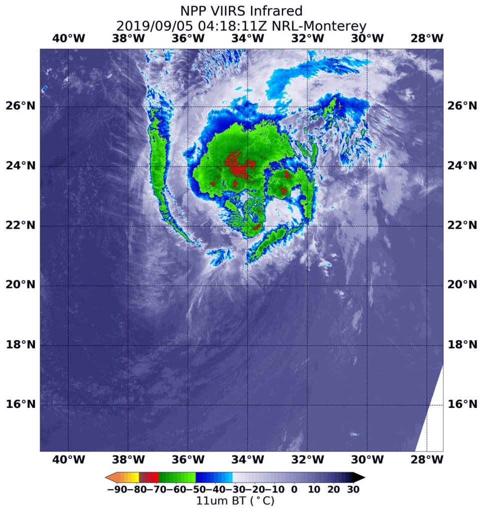
NASA-NOAA’s Suomi NPP satellite used infrared light to analyze the strength of storms in the remnants of Tropical Storm Gabrielle. Infrared data provides temperature information, and the strongest thunderstorms that reach high into the atmosphere have the coldest cloud top temperatures.
On Sept. 5 at 12:18 a.m. EDT (0418 UTC), the Visible Infrared Imaging Radiometer Suite (VIIRS) instrument aboard Suomi NPP found strongest thunderstorms northeast of the center had cloud top temperatures as cold as minus 70 degrees Fahrenheit (minus 56.6 Celsius). Cloud top temperatures that cold indicate strong storms with the potential to generate heavy rainfall. The southern quadrant of the storm appeared to be almost devoid of clouds because of outside winds blowing from the southwest, or southwesterly vertical wind shear.
In general, wind shear is a measure of how the speed and direction of winds change with altitude. Tropical cyclones are like rotating cylinders of winds. Each level needs to be stacked on top each other vertically in order for the storm to maintain strength or intensify. Wind shear occurs when winds at different levels of the atmosphere push against the rotating cylinder of winds, weakening the rotation by pushing it apart at different levels.
NOAA’s National Hurricane Center (NHC) noted in the discussion on Sept. 5, “Although Gabrielle could experience some intensity fluctuations during the next 24 hours, the cyclone should remain in a rather harsh environment during the next 36 to 48 hours, due to south to southwesterly vertical [wind] shear, some dry air in the middle portions of the atmosphere, and oceanic sea surface temperatures on the order of 25 to 26 Celsius.” Afterward, gradual strengthening is forecast as Gabrielle moves into a more favorable environment.
At 5 a.m. EDT (0900 UTC) NOAA’s National Hurricane Center (NHC) said the center of Tropical Storm Gabrielle was located near latitude 21.9 degrees north and longitude 35.0 degrees west. That’s about 825 miles (1,330 km) west-northwest of the Cabo Verde Islands. Gabrielle is moving toward the northwest near 8 mph (13 kph), and this motion is expected to continue for the next few days with an increase in forward speed. Maximum sustained winds remain near 50 mph (85 kph) with higher gusts. The estimated minimum central pressure is 1002 mb (29.59 inches).
The NHC said, “Little change in strength is forecast during the next couple of days. Afterward, some slow strengthening is expected to begin by this weekend.”
For updated forecasts, visit: www.nhc.noaa.gov