Aug. 19, 2020 – NASA-NOAA Satellite Provides Overnight Watch on Hurricane Genevieve
NASA-NOAA’s Suomi NPP satellite kept an eye on Hurricane Genevieve overnight and provided infrared imagery to forecasters who were monitoring the storm’s strength, structure and size. Because Genevieve is close to the coast of western Mexico, warnings and watches were still in effect.
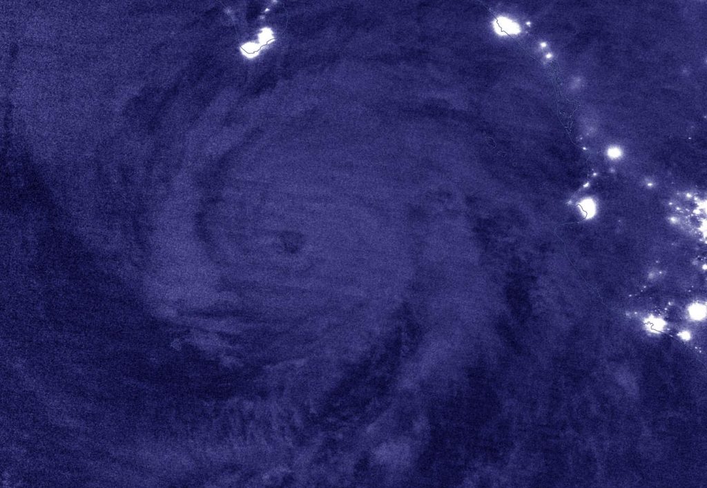
NASA’s Night-Time View of Genevieve
The Visible Infrared Imaging Radiometer Suite (VIIRS) instrument aboard Suomi NPP provided a nighttime image of Hurricane Genevieve on Aug. 18 at 8 p.m. EDT (Aug. 19 at 0000 UTC).The hurricane’s eye was still visible and well defined. It was surrounded by powerful thunderstorms, although deep convection is generally lacking over the southwestern portion of the circulation. The image was created using the NASA Worldview application.
Warnings and Watches on Aug. 19
NOAA’s National Hurricane Center issued a Hurricane Warning for the southern Baja California peninsula from Los Barriles to Todos Santos, Mexico. A Tropical Storm Warning is in effect for the west coast of the Baja California peninsula from north of Todos Santos to Cabo San Lazaro, and a Tropical Storm Watch is in effect for the east coast of the Baja California peninsula from Los Barriles to La Paz.
Hurricane Genevieve’s Status on Aug. 19
At 11 a.m. EDT (1500 UTC), the center of Hurricane Genevieve was located near latitude 20.9 degrees north and longitude 109.7 degrees west. That puts the eye about 140 miles (225 km) south of the southern tip of Baja California, Mexico. The estimated minimum central pressure is 959 millibars. Genevieve was moving toward the north-northwest near 9 mph (15 kph).
Maximum sustained winds are near 115 mph (185 km/h) with higher gusts. Genevieve is a category 3 hurricane on the Saffir-Simpson Hurricane Wind Scale.
The NHC Forecast for Genevieve
NOAA’s NHC forecast noted, “Gradual weakening is forecast over the next couple of days, but Genevieve is expected to remain a strong hurricane while it passes west of the southern Baja California peninsula. A turn toward the northwest is expected this afternoon or tonight, with this motion continuing through Friday night. On the forecast track, the center of Genevieve is expected to move near but just southwest of the southern portion of the Baja California peninsula tonight and Thursday, and move away from the peninsula on Friday.”
About NASA’s EOSDIS Worldview
NASA’s Earth Observing System Data and Information System (EOSDIS) Worldview application provides the capability to interactively browse over 700 global, full-resolution satellite imagery layers and then download the underlying data. Many of the available imagery layers are updated within three hours of observation, essentially showing the entire Earth as it looks “right now.”
NASA Researches Earth from Space
For more than five decades, NASA has used the vantage point of space to understand and explore our home planet, improve lives and safeguard our future. NASA brings together technology, science, and unique global Earth observations to provide societal benefits and strengthen our nation. Advancing knowledge of our home planet contributes directly to America’s leadership in space and scientific exploration.
For updated forecasts, visit: www.nhc.noaa.gov