Aug. 23, 2020 – NASA Infrared Imagery Shows Tropical Storm Laura Soaking Hispaniola
Very powerful storms with heavy rainmaking capability reach high into the atmosphere and those have very cold cloud top temperatures. Infrared imagery from NASA’s Terra satellite measures those temperatures and found those kind of powerful storms in Tropical Storm Laura drenching Hispaniola.

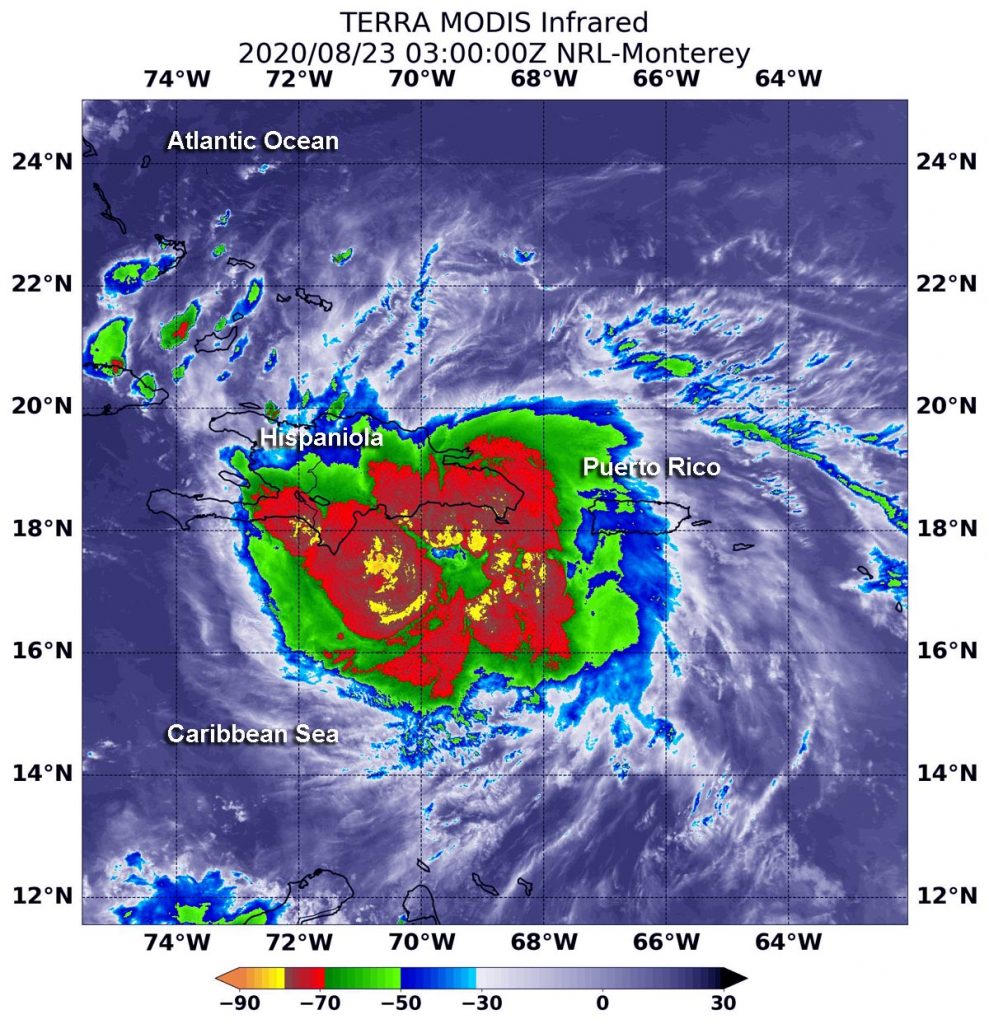
CAPTION: On Aug. 22 at 11 p.m. EDT (Aug. 23 at 0300 UTC) the MODIS instrument that flies aboard NASA’s Terra satellite revealed the most powerful thunderstorms (yellow) surrounded Laura’s center where cloud top temperatures were as cold as or colder than minus 80 degrees Fahrenheit (minus 62.2 Celsius). Strong storms with cloud top temperatures as cold as minus 70 degrees (red) Fahrenheit (minus 56.6. degrees Celsius) surrounded those areas and blanketed Hispaniola and were dropping large amounts of rain. Credit: NASA/NRL
Warnings and Watches on Sunday, August 23, 2020
NOAA’s National Hurricane Center (NHC) issued many warnings and watches on Sunday, Aug. 23.
Tropical Storm Warning is in effect for the northern coast of the Dominican Republic from Cabo Engano to the border with Haiti; the southern coast of the Dominican Republic from Cabo Engano to Punta Palenque; the northern coast of Haiti from Le Mole St. Nicholas to the border with the Dominican Republic; the southeastern Bahamas and the Turks and Caicos Islands; and the Cuban provinces of Camaguey, Las Tunas, Holguin, Guantanamo, Santiago de Cuba, Granma, Ciego De Avila, Sancti Spiritus, Villa Clara, Cienfuegos, Matanzas, Mayabeque, La Habana, and Artemisa.
A Tropical Storm Watch is in effect for the central Bahamas, Andros Island, the Florida Keys from Ocean Reef to Key West and the Dry Tortugas, Florida Bay and the Cuban province of Pinar Del Rio.
NASA’s Infrared Data Reveals Heavy Rainmakers
Tropical cyclones are made of up hundreds of thunderstorms, and infrared data can show where the strongest storms are located using infrared data which provides temperature information. The strongest thunderstorms that reach highest into the atmosphere have the coldest cloud top temperatures.
On Aug. 22 at 11 p.m. EDT (Aug. 23 at 0300 UTC), the Moderate Resolution Imaging Spectroradiometer or MODIS instrument that flies aboard NASA’s Terra satellite used infrared light to analyze the strength of storms within Laura. MODIS found the most powerful thunderstorms surrounded Laura’s center, where cloud top temperatures were as cold as or colder than minus 80 degrees Fahrenheit (minus 62.2 Celsius). NASA research has found that cloud top temperatures that cold indicate strong storms with the potential to generate heavy rainfall.
Strong storms with cloud top temperatures as cold as minus 70 degrees Fahrenheit (minus 56.6. degrees Celsius) surrounded those areas and blanketed Hispaniola. They were also dropping large amounts of rain.
The 8 a.m. EDT NHC Forecast Discussion on Laura noted, “Laura has maintained an impressive convective pattern despite the center being located over extreme south-central Dominican Republic. Numerous cloud tops of minus 85 to 90 degrees Celsius have been noted over the Barahona peninsula, an indication that extremely heavy rainfall has been occurring there.”
Forecasters at NOAA’s NHC use NASA’s infrared data in their forecast. One of the key messages on Laura is about its rainfall potential. NHC noted at 8 a.m. EDT Laura continued “bringing torrential rainfall and life-threatening flooding to the Dominican Republic and Haiti (Hispaniola).”
Laura’s Status on July 26, 2020
At 8 a.m. EDT (1200 UTC), the center of Tropical Storm Laura was located near latitude 19.1 degrees north and longitude 72.1 degrees west. That is about 40 miles (65 km) north-northeast of Port Au Prince, Haiti.
Laura is moving toward the west-northwest near 18 mph (30 kph), and this general motion is expected over the next few days. Maximum sustained winds are near 45 mph (75 kph) with higher gusts. No significant change in strength is forecast during the next 36 to 48 hours while Laura moves over or near Hispaniola and Cuba. The estimated minimum central pressure based on nearby surface observations is 1005 millibars.
Laura’s Forecast from NHC
On the forecast track, the center of Laura will move across Hispaniola this morning, be near or over Cuba tonight and Monday, and over the southeastern Gulf of Mexico Monday night and Tuesday. Strengthening is forecast once Laura moves into the Gulf of Mexico Monday night and Tuesday.
NASA researches these storms to determine how they rapidly intensify, develop and behave.
Typhoons/hurricanes are the most powerful weather events on Earth. NASA’s expertise in space and scientific exploration contributes to essential services provided to the American people by other federal agencies, such as hurricane weather forecasting.
For updated forecasts and additional information on rainfall, winds, storm surge, visit: www.nhc.noaa.gov
