June 12, 2019 – NASA Reveals Tropical Cyclone Vayu’s Compact Center
Visible imagery from NASA’s Aqua satellite showed Tropical Cyclone Vayu has a compact central dense overcast cloud cover. Vayu’s center was off-shore from India’s Gujarart coast.
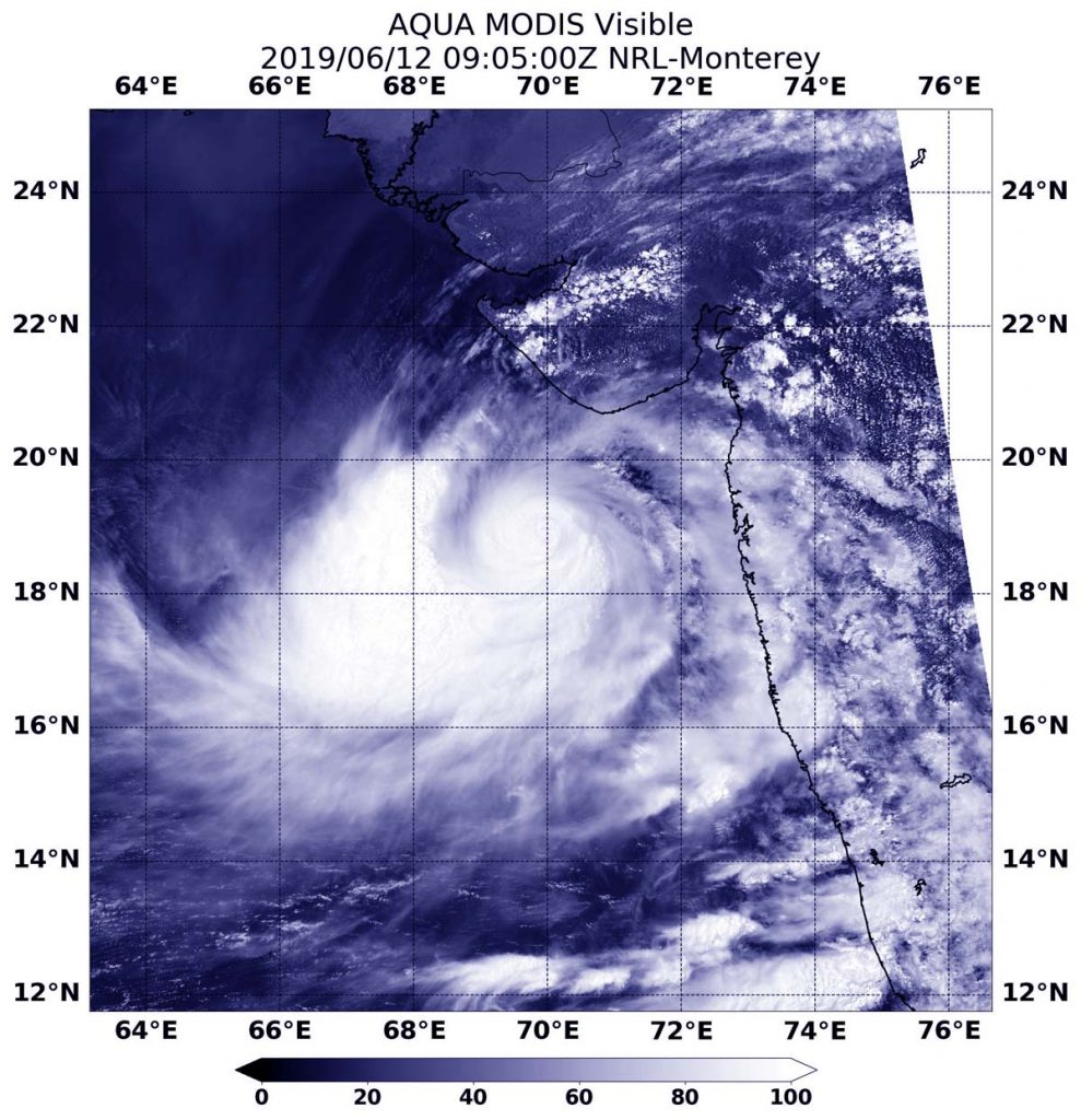
On June 12 at 4:05 a.m. EDT (0905 UTC), the MODIS instrument aboard NASA’s Aqua satellite provided a visible image of Tropical Cyclone Vayu and showed a compact center of circulation. Credit: NASA /NRL
On June 12 at 4:05 a.m. EDT (0905 UTC), the Moderate Resolution Imaging Spectroradiometer or MODIS instrument aboard NASA’s Aqua satellite provided a visible image of Vayu. Vayu’s center was off the western coast of India, in the Arabian Sea. Although hurricane-strength, the MODIS image showed a cloud-filled center of circulation and compact central dense overcast feature, approximately 90 to 100 nautical miles in diameter. The MODIS visible image also showed a thick band of thunderstorms wrapped into the low-level center from the western and southern quadrants. Meanwhile, satellite microwave imagery revealed a small eye beneath that overcast.
At 11 a.m. EDT (1500), the Joint Typhoon Warning Center reported that Tropical Cyclone Vayu was located near 19.4 degrees north latitude and 69.7 east longitude. That is 376 nautical miles south-southeast of Karachi, Pakistan. Vayu has tracked to the north-northwest. Maximum sustained winds were near 90 knots (104 mph/167 kph).
The Joint Typhoon Warning Center forecasts Vayu to strengthen slightly over the next day. Vayu is forecast to continue tracking north and turn to the northwest, with its center keeping off shore from India as it moves toward Pakistan. The latest forecast turns Vayu to the west, keeping it from a landfall through June 17.
June 11, 2019 – NASA Takes Tropical Cyclone‘s Vayu’s Temperature
NASA’s Aqua satellite passed over the Northern Indian Ocean and took the temperature of Tropical Cyclone Vayu as it moved northward in the Arabian Sea. NASA found the storm intensifying. Warnings are now in effect for India’s Gujarat coast.
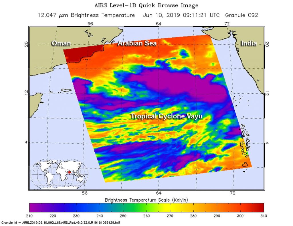
On June 10, at 0511 UTC (0911 UTC) the AIRS instrument aboard NASA’s Aqua satellite analyzed cloud top temperatures of Tropical Cyclone Vayu in infrared light. AIRS found coldest cloud top temperatures (purple) of strongest thunderstorms were as cold as or colder than minus 63 degrees Fahrenheit (minus 53 degrees Celsius). Credit: NASA JPL/Heidar Thrastarson
Infrared light enables NASA to take the temperatures of clouds and thunderstorms that make up tropical cyclones. The stronger the storms are indicate that they extend high into the troposphere and have cold cloud top temperatures.
An infrared look by NASA’s Aqua satellite on June 10, at 0511 UTC (0911 UTC) revealed where the strongest storms were located within Tropical Cyclone Vayu, formerly known as Tropical Cyclone 02A. The Atmospheric Infrared Sounder or AIRS instrument aboard NASA’s Aqua satellite analyzed cloud top temperatures and found cloud top temperatures of strongest thunderstorms as cold as or colder than minus 63 degrees Fahrenheit (minus 53 degrees Celsius) circling the center and in thunderstorms northwest of the center. Cloud top temperatures that cold indicate strong storms that have the capability to create heavy rain.
On June 11, cloud top temperatures continued to cool, as Vayu intensified. The Joint Typhoon Warning Center stated, “multi-spectral satellite imagery showed “tightly-curved banding wrapping into a formative, small eye, which supports the initial position with good confidence.” Satellite imagery showed Vayu has a compact core, approximately 90 nautical miles in diameter with bands of thunderstorms wrapping around it from the western quadrant.
On June 11 at 5 a.m. EDT (0900 UTC), the center of Tropical Cyclone Vayu was located near latitude 16.4 degrees south and longitude 70/9 degrees east. Vayu was moving to the north and had maximum sustained winds were near 65 knots (75 mph/120 kph) making the storm a category one hurricane on the Saffir-Simpson Hurricane Wind Scale.
The Joint Typhoon Warning Center expects Vayu to intensify quickly, peaking at 95 knots (109 mph/176 kph) on June 12 before starting to weaken on June 13. That means hurricane-force winds, storm surge and heavy rain can be expected along the western coast of India is Vayu moves north over the next several days.
For updated forecasts from the India Meteorological Department, visit: http://www.imd.gov.in
June 10, 2019 – NASA Catches Development of Tropical Cyclone 02A
Visible imagery from NASA’s Terra satellite provided confirmation of the development of Tropical Cyclone 02A in the Arabian Sea, Northern Indian Ocean.
On June 10, 2019, the MODIS instrument aboard NASA’s Terra satellite provided a visible image of Tropical Cyclone 02A in the Northern Indian Ocean, off the western coast of India. Credit: NASA Worldview, Earth Observing System Data and Information System (EOSDIS)
On June 10, the Moderate Resolution Imaging Spectroradiometer or MODIS instrument aboard NASA’s Terra satellite provided a visible image of 02A that showed thunderstorms circling the low-level center. MODIS imagery also showed some clouds and thunderstorms were offset to the northwest of the center. That’s a result of outside winds or vertical wind shear, blowing from the southeast and pushing some clouds to the northwest.
Satellite imagery revealed that the sea surface temperatures are warm enough to support further development of Tropical Cyclone 02A, and forecasters at the Joint Typhoon Warning Center expect some strengthening over the next couple of days.
At 11 a.m. EDT (1500 UTC) on Monday, June 10, 2019, Tropical Cyclone 02A was centered near 13.7 degrees north latitude and 70.8 east longitude. That puts the center about 350 nautical miles south-southwest of Mumbai, India. 02A was moving to the north-northwest at 8 knots (9 mph/15 kph). Maximum sustained winds were near 45 knots (52 mph/83 kph).
The Joint Typhoon Warning Center forecast noted that the storm is expected to peak on June 12 when maximum sustained winds reach 60 knots (69 mph/111 kph). ”The cyclone is expected to continue tracking generally northward along the western periphery of a subtropical ridge (elongated area of high pressure) anchored over India, making landfall near Jamnagar around 96 hours [June 14] and track inland.”
June 05, 2019 – NASA Estimates Heavy Texas and Louisiana Rainfall from Gulf Weather System
Earlier in the week, NOAA’s National Hurricane Center was monitoring a low-pressure system in the Gulf of Campeche that has now moved along the Texas and Louisiana coastlines, bringing heavy rainfall. On June 5, NASA used a constellation of satellites to estimate that rainfall.
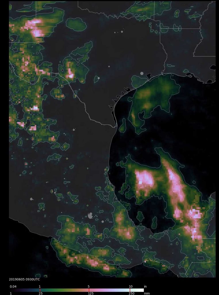
An IMERG precipitation product shows rainfall estimates of 10 inches between June 3 at 0000 UTC (June 2 at 8 p.m. EDT) to June 5 at 5:30 a.m. EDT (0930 UTC). Credit: NASA/JAXA, Matt Lammers
On June 5, the National Weather Service National Prediction Center in College Park, Maryland noted that there is a “High risk for flash flooding across parts of southeast Texas and southern Louisiana Today into Tonight.”
Estimating Heavy Rainfall
Forming in the Bay of Campeche on June 3, tropical disturbance 91L looked ripe to develop into a minor tropical cyclone before making landfall along the Gulf Coast of Texas, but high wind shear inhibited its development. On June 4, the National Hurricane Center dropped the chances that it would consolidate into a depression to 20 percent. On June 5, although the low-pressure area is expected to remain disorganized, it is expected to generate a lot of rainfall for the Gulf coast states.
“NASA’s IMERG data showed the tropical rainfall it brought has led to flash flooding throughout the Houston area on the morning of June 5, dumping more than 10 inches on a large region southwest of the city,” said Matt Lammers of NASA’s Goddard Space Flight Center in Greenbelt, Maryland.
The Integrated Multi-satellitE Retrievals for GPM (IMERG) creates a merged precipitation product from the Global Precipitation Measurement mission or GPM constellation of satellites. At NASA Goddard an IMERG rainfall accumulation image was created from June 3 at 0000 UTC (June 2 at 8 p.m. EDT) to June 5 at 5:30 a.m. EDT (0930 UTC). Most of the precipitation in the Houston area has fallen since the latest IMERG Early processing, so rainfall totals will be higher.
The National Weather Service noted that the moisture interacting with an upper level low moving into the Southern Plains. Heavy to excessive rainfall is likely across southeast Texas and into the Lower Mississippi Valley today, with a high risk for flash flooding where as much as 4 to 7 plus inches more of rain is in the forecast from extreme southeast Texas into southwest Louisiana.
What Is NASA’s IMERG?
NASA’s GPM or Global Precipitation Measurement mission satellite provides information on precipitation from its orbit in space. GPM is a joint mission between NASA and the Japan Aerospace Exploration Agency or JAXA. GPM also utilizes a constellation of other satellites to provide a global analysis of precipitation that are used in the IMERG calculation.
At NASA’s Goddard Space Flight Center in Greenbelt, Maryland, those data are incorporated into NASA’s IMERG or Integrated Multi-satellitE Retrievals for GPM. IMERG is used to estimate precipitation from a combination of passive microwave sensors, including the Global Precipitation Measurement (GPM) mission’s core satellite’s GMI microwave sensor and geostationary IR (infrared) data. IMERG real-time data are generated by NASA’s Precipitation Processing System every half hour and are normally available within six hours.
IMERG creates a merged precipitation product from the GPM constellation of satellites. These satellites include DMSPs from the U.S. Department of Defense, GCOM-W from the Japan Aerospace Exploration Agency (JAXA), Megha-Tropiques from the Centre National D’etudies Spatiales (CNES) and Indian Space Research Organization (ISRO), NOAA series from the National Oceanic and Atmospheric Administration (NOAA), Suomi-NPP from NOAA-NASA, and MetOps from the European Organisation for the Exploitation of Meteorological Satellites (EUMETSAT). All of the instruments (radiometers) onboard the constellation partners are inter-calibrated with information from the GPM Core Observatory’s GPM Microwave Imager (GMI) and Dual-frequency Precipitation Radar (DPR).
Flood Watches
There is a moderate to high risk for flash flooding across parts of southeast Texas and southern Louisiana on Wednesday, June 5.
The National Weather Service in Houston/Galveston, Texas noted, “Numerous showers and thunderstorms are expected today. Rainfall will be locally heavy at times. A Flash Flood Watch is in effect through this evening. Rainfall totals will average 3 to 5 inches with isolated totals approaching 8 inches. Strong onshore winds will will produce elevated tides today and water levels at high tide could exceed 3.5 feet. Minor coastal flooding will be possible and a Coastal Flood Advisory is in effect.
Movement of the Weather System
The National Weather Service noted that “heavy to excessive rainfall threat shifts from the lower Mississippi Valley on Wednesday into the Central Gulf Coast states and eventually the U.S. Southeast by the end of the week.” For updated forecasts, visit: www.weather.gov
June 04, 2019 – NASA-NOAA Satellite Sees System 91L’s Reach into the Western Gulf of Mexico
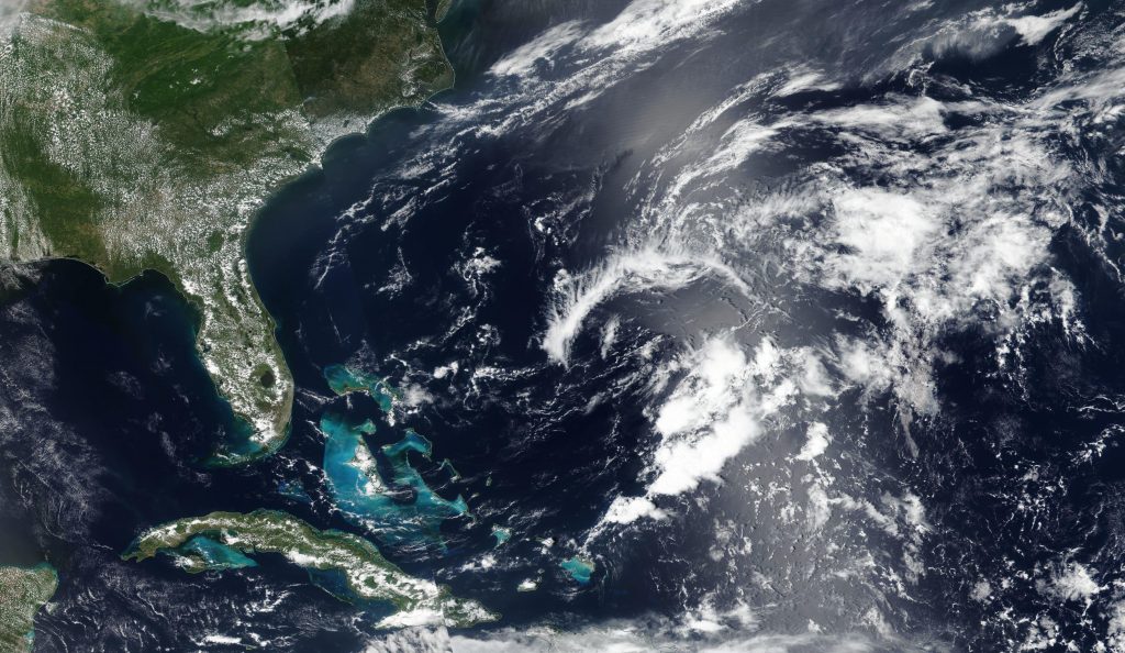
System 91L is an area of tropical low pressure located in the Bay of Campeche. On June 3, when NASA-NOAA’s Suomi NPP satellite passed the western Gulf of Mexico, it captured an image of the storm that showed its extensive reach.
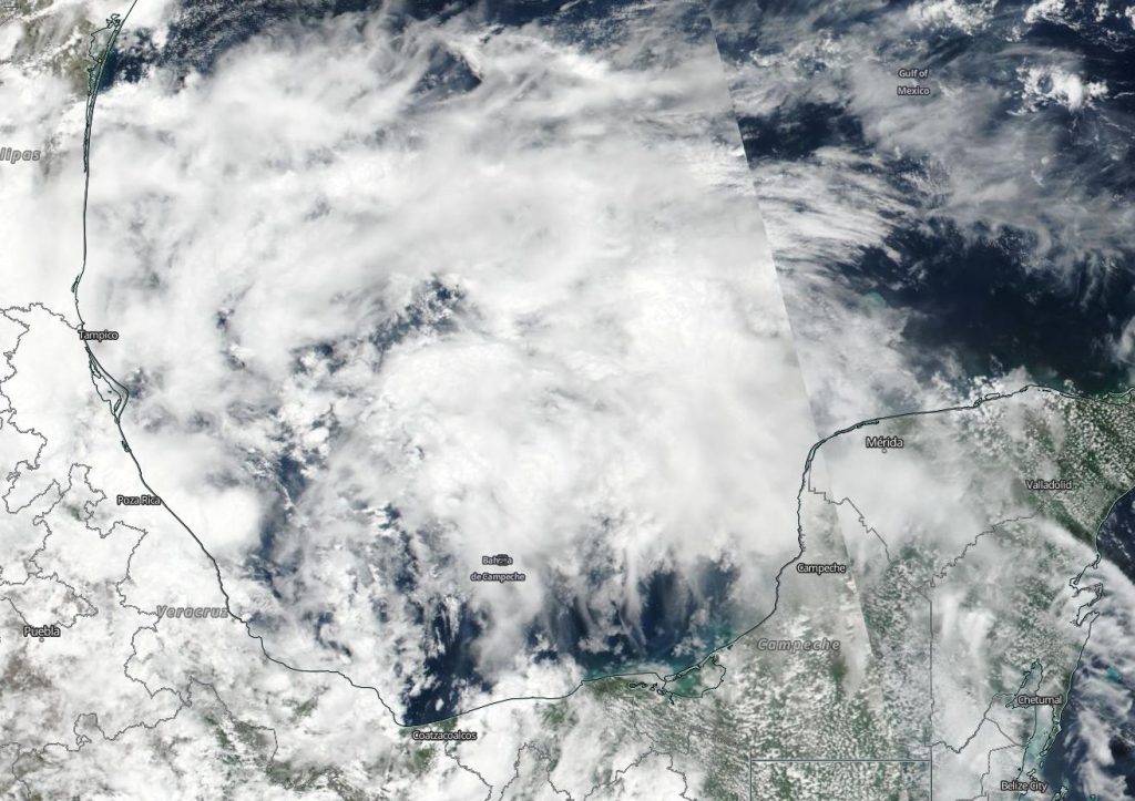
NASA-NOAA’s Suomi NPP satellite passed over the Gulf of Mexico and captured a visible image of developing low pressure System 91L on June 3, 2019. Clouds associated with the system filed the Bay of Campeche and stretched north into the western Gulf of Mexico. Credit: NASA Worldview, Earth Observing System Data and Information System (EOSDIS).
The Visible Infrared Imaging Radiometer Suite (VIIRS) instrument aboard Suomi NPP provided a visible image of the storm. The VIIRS image showed fragmented bands of thunderstorms around System 91L’s circulation center which filled the Bay of Campeche and stretched north into the western Gulf of Mexico. System 91L’s clouds extend from Mexico’s Yucatan state to the west bordering and including the states of Campeche, Tabasco, Veracruz and as far north as Tamaulipas.
At 8 a.m. EDT on June 4, NOAA’s National Hurricane Center or NHC noted that System 91L now has a 40 percent chance to form into a depression over the next two days. “Shower and thunderstorm activity associated with a broad area of low pressure located over the southwestern Gulf of Mexico has decreased since yesterday and remains disorganized. This system could briefly become a tropical depression before moving inland over northeastern Mexico later today or tonight. “
Even if System 91L doesn’t develop into a depression, it’s still packing a punch with rainfall.
The NHC noted “the disturbance will likely produce heavy rainfall over portions of eastern Mexico, southeastern Texas and the Lower Mississippi Valley during the next few days. Interests along the Gulf coast of Mexico should monitor the progress of this system.”
June 03, 2019 – NASA Sees Strong Storms in Developing Gulf System 91L
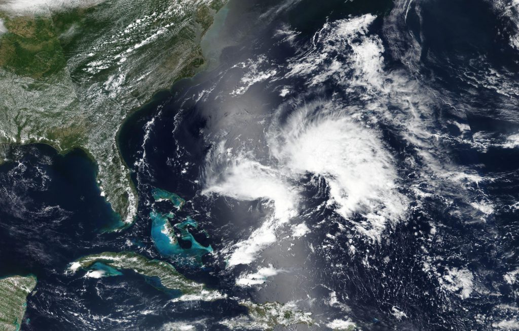
NASA’s Aqua satellite used infrared light to analyze the strength of storms in the developing low pressure area designated as System 91L as it moved through the Gulf of Campeche just north of Mexico’s Yucatan Peninsula.
On June 3 at 4:05 a.m. EDT (0805 UTC), the MODIS instrument that flies aboard NASA’s Aqua satellite gathered infrared data on developing System 91L. Strongest thunderstorms (yellow) created a southern ring around the center from west to east, where cloud top temperatures were as cold as minus 80 degrees Fahrenheit (minus 62.2 Celsius). Credit: NASA/NRL
Infrared data provides temperature information, and the strongest thunderstorms that reach high into the atmosphere have the coldest cloud top temperatures.
On June 3 at 4:05 a.m. EDT (0805 UTC), the Moderate Imaging Spectroradiometer or MODIS instrument that flies aboard NASA’s Aqua satellite gathered infrared data on developing System 91L. Strongest thunderstorms created a southern ring around the center from west to east, where cloud top temperatures were as cold as minus 80 degrees Fahrenheit (minus 62.2 Celsius). Cloud top temperatures that cold indicate strong storms with the potential to generate heavy rainfall. Those strongest storms were located just off the coast of the state of Campeche and the eastern part of the state of Tabasco.
On June 3 at 2 p.m. EDT, the National Hurricane Center (NHC) noted that System 91L has a medium chance to develop into a depression within the next 24 hours. NHC Forecaster Zelinsky noted in the update, “Showers and thunderstorms associated with a broad area of low pressure located over the Bay of Campeche have become a little better organized since yesterday. However, recent satellite-based wind data indicate that the circulation of the low is elongated and poorly defined.”
This system is forecast to move slowly northwestward toward the northeastern coast of Mexico, and could become a tropical cyclone before it moves inland in a day or two.
Even if System 91L does not develop into a tropical cyclone, forecasters at NHC said the disturbance will likely produce heavy rainfall over portions of southern and eastern Mexico during the next few days. Heavy rainfall is also likely to spread over southeastern Texas and Louisiana through Thursday.
Several computer models take System 91L on a northerly path, and interests along the Gulf coast of Mexico should monitor the progress of this system.
Subtropical Storm Andrea was gone before the storm could even reach Tropical Storm status. The last advisory for this storm was issued at 5:00pm AST/EDT on May 21, 2019.
NASA’s Earth Observing System Data and Information System (EOSDIS) Worldview application provides the capability to interactively browse over 700 global, full-resolution satellite imagery layers and then download the underlying data. Many of the available imagery layers are updated within three hours of observation, essentially showing the entire Earth as it looks “right now.” The storm was dissipating when the Suomi NPP satellite captured this image on May 21, 2019. Credit: NASA Worldview, Earth Observing System Data and Information System (EOSDIS).
Andrea’s formation marks the fifth consecutive year that a named storm has developed before the official start of Atlantic hurricane season on June 1. Andrea went from a subtropical storm to a remnant low in two days. Its location 370 km west southwest of Bermuda meant that no coastal watches or warnings were necessary for this storm. Its maximum sustained winds are 35 mph and the present movement of the low is east northeast at 8 mph.
The system is expected to dissipate by Wednesday morning.
There are no other storms in the Atlantic basin or Central Pacific basin. There is a disturbance in the East North Pacific basin that has a 50% chance of cyclone formation in the next 5 days.
May 21, 2019 – Subtropical Storm Andrea Jumps the Gun As the First Storm of 2019 Atlantic Season
Andrea becomes the first subtropical storm for the 2019 season although we are two weeks short of the official start date of June 1. This storm was first spotted on Monday, May 20, 2019 forming over the western Atlantic.
NASA’s Earth Observing System Data and Information System (EOSDIS) Worldview application provides the capability to interactively browse over 700 global, full-resolution satellite imagery layers and then download the underlying data. Many of the available imagery layers are updated within three hours of observation, essentially showing the entire Earth as it looks “right now.” The storm was just forming when the Suomi NPP satellite captured this image on May 20, 2019. Credit: NASA Worldview, Earth Observing System Data and Information System (EOSDIS).
At present the storm is located 295 miles west southwest of Bermuda and is moving north at 5 knots. Maximum sustained winds are near 40 mph (65 km/h) with higher gusts extending outward up to 60 miles from the center. Bermuda is within the zone of coverage for this storm, although at present there are no coastal watches or warnings in effect. The storm is expected to veer northeast later today. On the forecast track, the center of Andrea is expected to remain southwest and south of
Bermuda during the next day or two.
Little change in strength is forecast today, followed by weakening
late tonight. Andrea is expected to dissipate on Wednesday.
May 15, 2019 – Ex-Tropical Cyclone Ann Moving Over Australia’s Cape York Peninsula
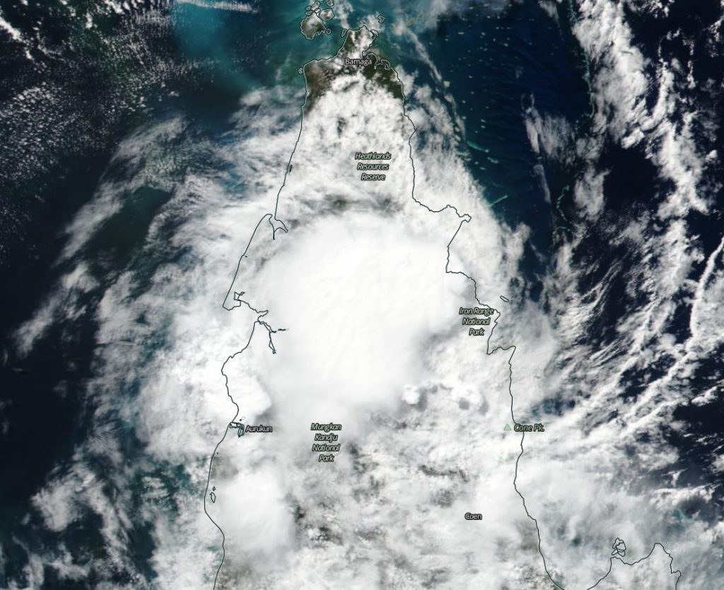
NASA-NOAA’s Suomi NPP satellite passed over the Southern Pacific Ocean and captured a visible image of the remnants of Tropical Cyclone Ann moving over Queensland’s Cape York Peninsula. Despite the storm weakening below tropical cyclone status, warnings remain active for strong winds and flooding potential.
The Australian Bureau of Meteorology or ABM issued a Strong Wind Warning for the North East Gulf of Carpentaria for today, May 15, and tomorrow, May 16. There is also a Flood Watch in effect for coastal catchments between Cooktown and Port Douglas.
NASA-NOAA’s Suomi NPP satellite passed over the Southern Pacific Ocean and captured a visible image of Ex-Tropical Cyclone Ann on May 15, 2019, as it continued to move over the Cape York Peninsula. Credit: NASA Worldview, Earth Observing System Data and Information System (EOSDIS).
Ex-Tropical Cyclone Ann has the potential to generate areas of heavy rainfall. ABM noted “Catchments remain wet following coastal showers and rain areas during the last few days, which will make stream rises and flooding more likely with the onset of heavy rainfall. Enhanced rainfall is expected to occur on the coastal catchments north of Port Douglas and through to Cooktown during Wednesday.” Heavy rainfall may also lead to flash flooding and the catchments likely to be affected include the Endeavour River and the Daintree River.
NASA-NOAA’s Suomi NPP satellite passed over the remnant clouds on May 15 and the Visible Infrared Imaging Radiometer Suite (VIIRS) instrument provided a visible image of the storm. The VIIRS image showed the center of the low pressure area in the middle of the northern Cape York Peninsula, framed by the Heartlands Resources Reserve to the north, the Iron Range National Park to the east, and the Mungkan Kandju National Park south of the circulation center.
The remnants of Ann are expected to move west into the Gulf of Carpentaria in the next day.
May 14, 2019 – NASA Finds Tropical Cyclone Ann Over the Great Barrier Reef
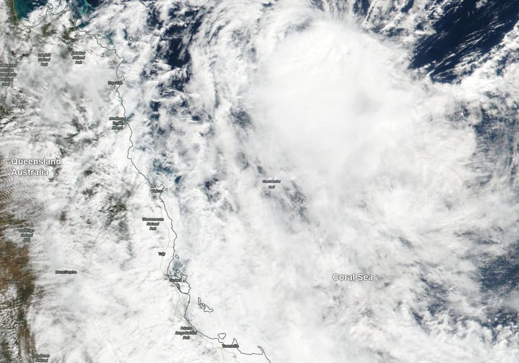
Australia’s world-famous Great Barrier Reef is located in the Coral Sea, east of Queensland and on May 14, Tropical Cyclone Ann was moving over it. From their orbit in space, NASA’s Terra and Aqua satellites passed over the Southern Pacific Ocean obtained visible and infrared imagery of the storm as it moved toward the Queensland coast.
On May 14, NASA’s Terra satellite provided a visible image of Tropical Cyclone Ann as it was moving over the Great Barrier Reef in the Coral Sea. Credit: NASA Worldview, Earth Observing System Data and Information System (EOSDIS)
The Great Barrier Reef is the world’s largest coral reef system. The Reef is made up of more than 2,900 individual reefs and 900 islands that cover more than stretching for over 1,429 miles (2,300 kilometers).
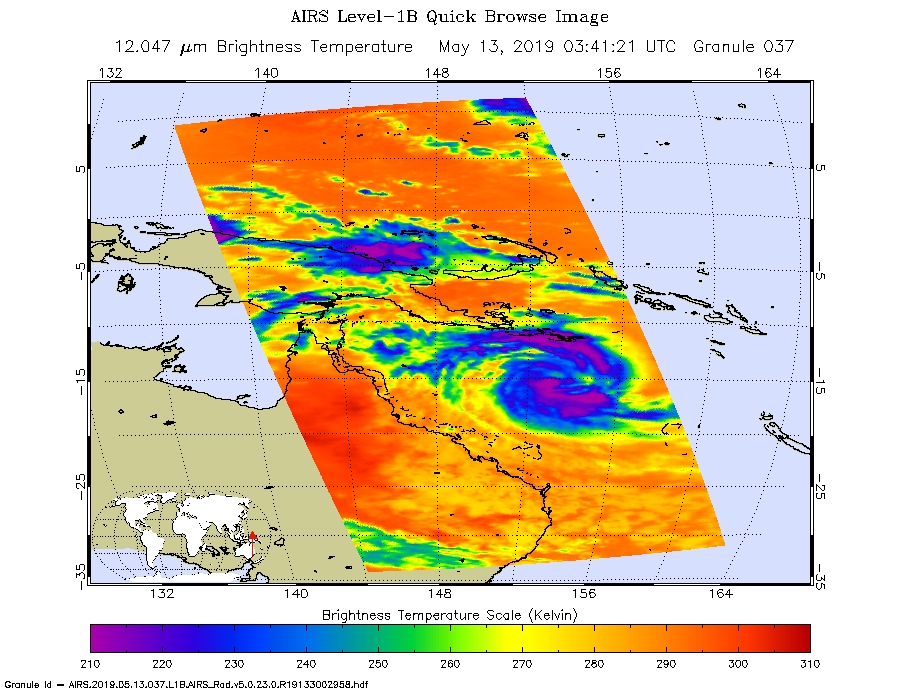
An infrared look at the tropical storm obtained by NASA’s Aqua satellite revealed where the strongest storms were located within Tropical Cyclone Ann on May 13 at 0341 UTC (May 12 at 11:41 p.m. EDT). The Atmospheric Infrared Sounder or AIRS instrument aboard NASA’s Aqua satellite analyzed cloud top temperatures and found cloud top temperatures of strongest thunderstorms as cold as or colder than minus 63 degrees Fahrenheit (minus 53 degrees Celsius) circling the center and in a large band of thunderstorms north of the center. Cloud top temperatures that cold indicate strong storms that have the capability to create heavy rain.
On May 13, at 0341 UTC (May 12 at 11:41 p.m. EDT) the AIRS instrument aboard NASA’s Aqua satellite analyzed cloud top temperatures of Tropical Cyclone Ann in infrared light. AIRS found coldest cloud top temperatures (purple) of strongest thunderstorms were as cold as or colder than minus 63 degrees Fahrenheit (minus 53 degrees Celsius). Credit: NASA JPL/Heidar Thrastarson
On May 14, NASA’s Terra satellite provided a visible image of the storm to forecasters. The Moderate Resolution Imaging Spectroradiometer or MODIS instrument aboard Terra captured the storm as it was moving over the Great Barrier Reef in the Coral Sea. Multispectral satellite imagery at the time showed that an exposed, well-defined low-level circulation center with a small area of convection flaring 50 nautical miles to the south.
Ann is weakening because it has run into increased vertical wind shear, that is, winds blowing at different directions at different levels of the atmosphere tearing at the storm’s structure. There is also dry air moving into Tropical Cyclone Ann at low and mid-levels of the atmosphere, preventing the development of thunderstorms that fuel the storm.
The Australian Bureau of Meteorology or ABM noted “Ex-tropical cyclone Ann expected to bring damaging winds and heavy rainfall to parts of northeast Queensland” and issued a Severe Weather Warning for damaging winds and heavy rainfall. The warning is for residents in parts of Peninsula, North Tropical Coast and Tablelands and Herbert and Lower Burdekin Forecast Districts.
Additional warnings in effect on May 14 include a Gale Warning for the Peninsula Coast and Cooktown Coast, and a Strong Wind Warning for the Cairns Coast, Townsville Coast and Mackay Coast.
Local impacts include strong winds and heavy rainfall. ABM cited “damaging winds, with peak gusts of around 90 kph (56 mph) may develop during Wednesday morning between about Lockhart River and Cooktown, including Lizard Island. The winds should gradually ease during Wednesday afternoon as the low moves across Cape York Peninsula.
Areas of heavy rainfall, which may lead to flash flooding is expected to develop along the coast and ranges between the Lockhart River and Port Douglas Tuesday night, May 14 and persist through Wednesday, May 15. A separate area of heavy rainfall, which may lead to flash flooding, may also develop about the coast and ranges between about Gordonvale and Ingham during early Wednesday morning. This should gradually ease during Thursday.”
ABM Warnings are also available through TV and Radio broadcasts, the Bureau’s website at www.bom.gov.au.
On May 14 at 5 a.m. EDT (0900 UTC), the center of Tropical Cyclone Ann was located near latitude 14.3 degrees south and longitude 146.9 degrees east. That is about 178 nautical miles northeast of Cairns Australia. Ann was moving to the west and had maximum sustained winds near 35 knots (40 mph / 65 kph).
The Joint Typhoon Warning Center expects Ann to make landfall within 24 hours to the north of Cape Melville National Park and Mungkan Kandju National Park, and dissipate less than a day later.