Bailu (Northwestern Pacific Ocean)

Aug. 23, 2019 – NASA Satellite Catches Tropical Storm Bailu’s U-Shape

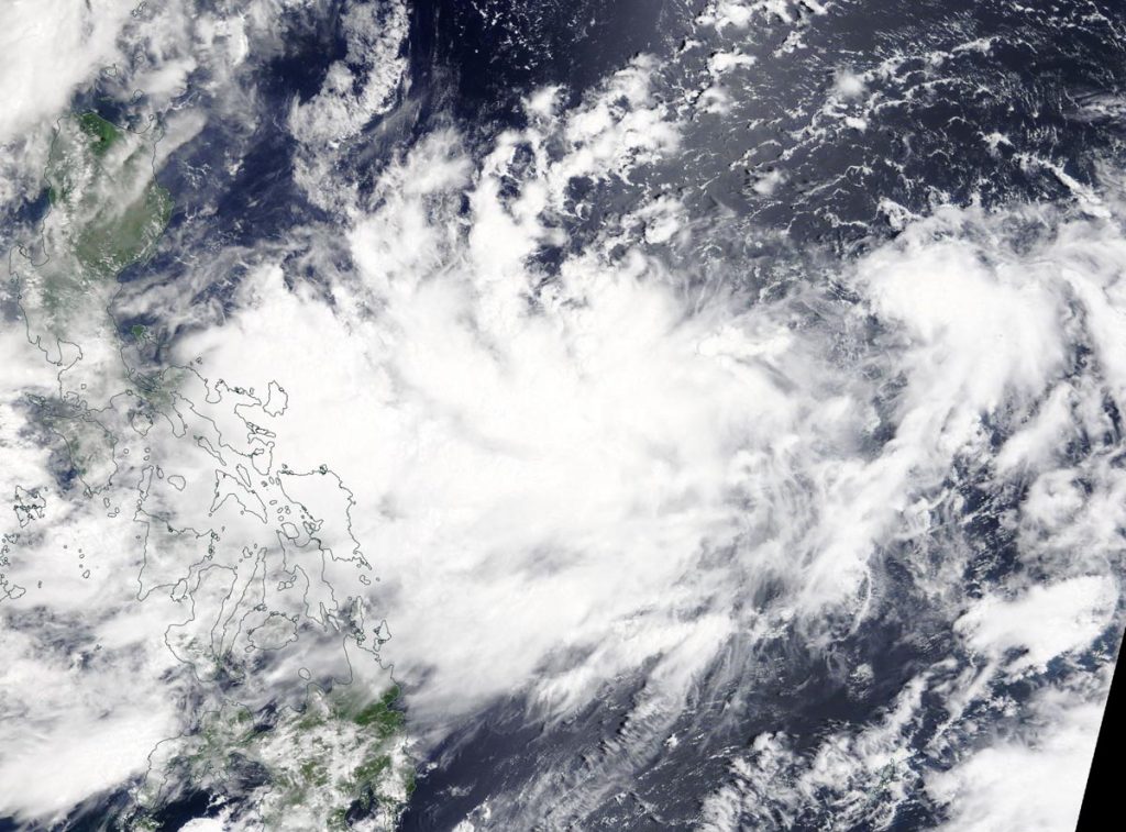
NASA’s Aqua satellite passed over the Northwestern Pacific Ocean and captured an image of Tropical Storm Bailu that appeared to have a U-shape.

On Aug. 23 at 12:55 a.m. EDT (04:55 UTC) the MODIS instrument aboard NASA’s Aqua satellite provided a visible image of Tropical Storm Bailu in the Northwestern Pacific Ocean, northeast of the Philippines. Credit: NASA/NRL

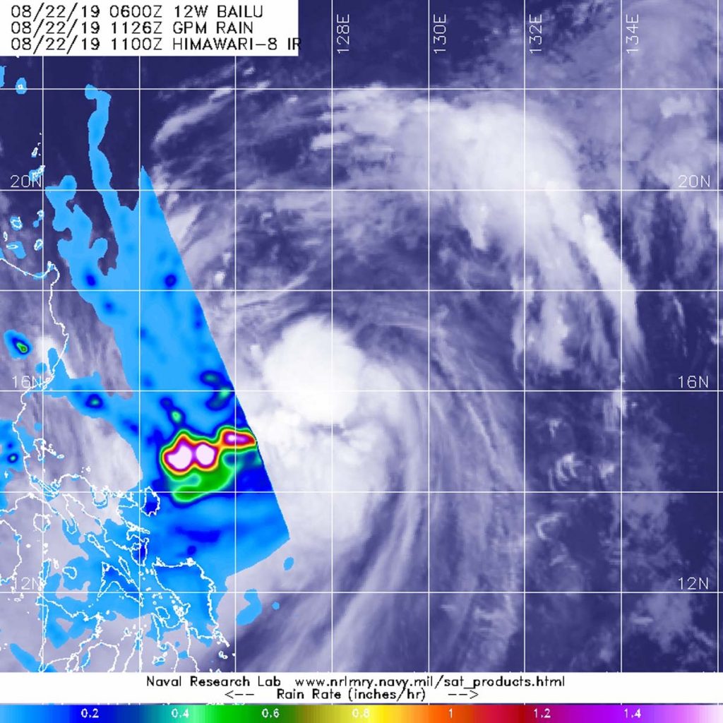
On Aug. 23 at 12:55 a.m. EDT (0455 UTC) the Moderate Resolution Imaging Spectroradiometer or MODIS instrument aboard NASA’s Aqua satellite provided a visible image of Bailu in the Philippine Sea. The storm’s has what appears to be a U-shape because of “deepening convection wrapping counterclockwise from the southwest to northeast,” according to the Joint Typhoon Warning Center. Deepening convection means stronger evaporation and rising air. Those factors form the clouds that create thunderstorms that make up a tropical cyclone.

At 5 a.m. EDT (0900 UTC), the center of Bailu was located near latitude 19.4 degrees north and longitude 124.5 degrees east. Bailu was about 417 nautical miles south-southeast of Taipei, Taiwan. Bailu was moving to the northwest and had maximum sustained winds near 45 knots (51.7 mph/83.3 kph).

The Joint Typhoon Warning Center expects Bailu to continue to track northwestward and skim extreme southern Taiwan on Aug. 24, before making landfall in China on Aug. 25. After landfall the system is expected to quickly weaken and is forecast to dissipate by Aug. 26.

Rob Gutro
NASA’s Goddard Space Flight Center, Greenbelt, Md.

Bailu – Northwestern Pacific Ocean

Aug. 22, 2019 – NASA Measures Rain Rate in Tropical Storm Bailu

The GPM satellite passed over the Northwestern Pacific Ocean and Tropical Storm Bailu and measured its rainfall rates.

GPM image of Bailu
The GPM core satellite passed over Tropical Storm Bailu at 7:26 a.m. EDT (1126 UTC) on August 22, 2019. GPM found heavy rainfall (pink) in a band of thunderstorms extending southwest of Bailu’s center where rain was falling at a rate of 40 mm (about 1.6 inches) per hour. GPM data was overlaid on infrared cloud imagery from Japan’s Himawari-8 satellite. Credit: NASA/JAXA/NRL

The Global Precipitation Measurement mission or GPM core satellite passed over Tropical Storm Bailu at 7:26 a.m. EDT (1126 UTC) on August 22, 2019. GPM found the heaviest rainfall was in a band of thunderstorms extending southwest of Bailu’s center where rain was falling at a rate of 40 mm (about 1.6 inches) per hour. GPM is a joint mission between NASA and the Japan Aerospace Exploration Agency, JAXA.

On August 22 at 11 a.m. EDT (1500 UTC), Tropical Storm Bailu had maximum sustained winds near 45 knots (52 mph/83 kph). Bailu is forecast to strengthen over the next day and a half. Bailu was centered near 17.3 degrees north latitude and 127.5 degrees east longitude. It was about 576 nautical miles south of Kadena Air Base, Okinawa Island, Japan. It was moving to the west-northwest.

The Joint Typhoon Warning Center forecasts calls for Bailu to make landfall in southern Taiwan on August 24 at typhoon status. The Central Weather Bureau of Taiwan is issuing Typhoon Warnings.

For updated forecasts, visit the Central Weather Bureau: https://www.cwb.gov.tw

By Rob Gutro
NASA’s Goddard Space Flight Center

Bailu – Northwestern Pacific Ocean

Aug. 21, 2019 – NASA Finds Tropical Depression Bailu Forms East of Philippines

NASA’s Terra satellite passed over the Northwestern Pacific Ocean and captured an image of newly developed Tropical Depression Bailu, east of the Philippines.

Terra image of Bailu
On Aug. 20, 2019, the MODIS instrument aboard NASA’s Terra satellite provided a visible image of Tropical Depression Bailu in the Northwestern Pacific Ocean. Credit: NASA Worldview, Earth Observing System Data and Information System (EOSDIS)

On Aug. 20, 2019, the Moderate Resolution Imaging Spectroradiometer or MODIS instrument aboard NASA’s Terra satellite provided a visible image of Bailu in the Philippine Sea. The storm appeared somewhat elongated.

At 11 a.m. EDT (1500 UTC), the center of Bailu was located near latitude 15.9 degrees north and longitude 130.7 degrees east. Bailu was about 674 nautical miles south-southwest of Kadena Air Base, Okinawa, Japan. Bailu was moving to the northwest and had maximum sustained winds near 30 knots (34.5 mph/55.5 kph).

The Joint Typhoon Warning Center expects Bailu to move northwest and make landfall in Taiwan, then proceed to a second landfall in southeastern China.

By Rob Gutro
NASA’s Goddard Space Flight Center