The Global Precipitation Measurement mission or GPM core satellite passed over Tropical Storm Kong-Rey and analyzed the rates in which rain was falling throughout the storm.
The GPM or Global Precipitation Measurement mission core observatory satellite passed above Kong-Rey on Oct. 5. GPM indicated that rain was falling at over 1.8 inches (45.7 mm) per hour within two areas of storms northwest of Kong-Rey’s center. Credit: NASA/JAXA/NRL
At the time GPM passed overhead, GPM’s Microwave Imager (GMI) instruments collected data that revealed moderate convective rainfall northwest of Kong-Rey’s center. GPM indicated that rain was falling at over 1.8 inches (45.7 mm) per hour within two areas of storms northwest of Kong-Rey’s center.
At 5 a.m. EDT (0900 UTC) on Friday, Oct. 5, the center of Tropical Storm Kong-Rey was located near 29.6 degrees north latitude and 125.9 degrees west longitude. Kong-Rey is about 211 nautical miles north-northwest of Kadena Air Base, Okinawa Island, Japan. Maximum sustained winds are near 63 mph (55 knots/102 kph) with higher gusts.
Kong-Rey is moving toward the north. A turn toward the northeast is expected to take the storm into the Sea of Japan. The storm is now weakening, and will become extra-tropical over northern Japan.
Oct. 04, 2018 – NASA Puts Together a Composite of Tropical Storm Kong-Rey
NASA’s IMERG combines data from many satellites to provide a look at rainfall occurring around the world. Those rainfall data were combined with visible imagery from NASA-NOAA’s Suomi NPP satellite to create a composite or fuller picture of Kong- Rey in the Northwestern Pacific Ocean as it weakened to a tropical storm.
NASA’s IMERG and NASA-NOAA’s Suomi NPP satellite imagery were combined to create a picture of the extent and rainfall of Tropical Storm Kong-Rey. IMERG found heavy rain falling (red) around the center and northwest of the center on Oct. 3, 2018. Credit: NASA Worldview, Earth Observing System Data and Information System (EOSDIS) /NOAA/JAXA
The Global Precipitation Measurement mission or GPM core satellite provided a look at distribution of rainfall within Kong-Rey. GPM is a joint mission between NASA and the Japan Aerospace Exploration Agency, JAXA. GPM found heaviest rain falling around the center and northwest of the center on Oct. 4, 2018.
The Visible Infrared Imaging Radiometer Suite (VIIRS) instrument aboard NASA-NOAA’s Suomi NPP satellite captured a visible light image that showed the western quadrant of Kong-Rey just east of Taiwan on Oct. 4.
The Status of Kong-Rey
At 11 a.m. EDT (1500 UTC) on Oct. 4, 2018, the Joint Typhoon Warning Center downgraded Kong-Rey from a typhoon to a tropical storm as maximum sustained winds dropped to 60 knots (69 mph/111 kph). Kong-Rey was centered near 26.1 degrees north latitude and 126.5 degrees east longitude. That’s approximately 88 nautical miles southwest of Kadena Air Base and has tracked north-northwestward.
Kong-Rey is forecast to turn to the north then northeast, and move into the Sea of Japan. The storm is now weakening, and will become extra-tropical over northern Japan.
About IMERG
NASA’s GPM or Global Precipitation Measurement mission satellite provides information on precipitation from its orbit in space. GPM is a joint mission between NASA and the Japan Aerospace Exploration Agency or JAXA. GPM also utilizes a constellation of other satellites to provide a global analysis of precipitation that are used in the IMERG calculation.
At NASA’s Goddard Space Flight Center in Greenbelt, Maryland, those data are incorporated into NASA’s IMERG or Integrated Multi-satellitE Retrievals for GPM. IMERG is used to estimate precipitation from a combination of passive microwave sensors, including the Global Precipitation Measurement (GPM) mission’s core satellite’s GMI microwave sensor and geostationary infrared data. IMERG real-time data are generated by NASA’s Precipitation Processing System every half hour and are normally available within six hours.
Oct. 03, 2018 – NASA Gets a Look at the Rainfall Rates within Typhoon Kong-Rey
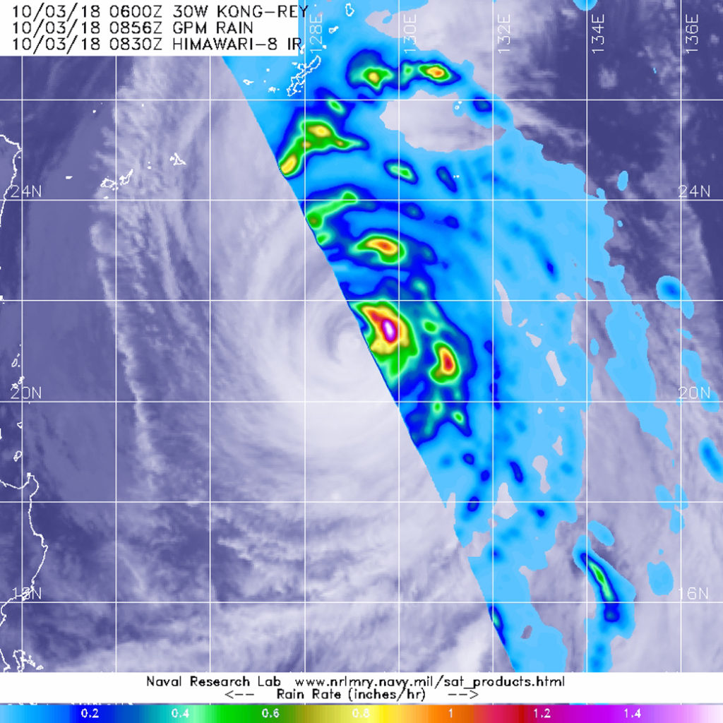
The Global Precipitation Measurement mission or GPM core satellite passed over Typhoon Kong-Rey moving through the Northwestern Pacific Ocean and found heaviest rainfall occurring in the storm’s eyewall.
The GPM core observatory satellite passed over Typhoon Kong-Rey on Oct. 3 at 4:36 a.m. EDT (0836 UTC) and measured rainfall within. Heaviest rainfall was occurring in the northeastern eyewall at a rate greater than 1.4 inches per hour. GPM data was overlaid on Japan’s Himawari-8 satellite infrared imagery. Credit: NASA/JAXA/NRL
The eyewall of a tropical cyclone refers to the powerful thunderstorms that form a ring around the open eye. In the eye, air descends and prevents cloud formation. Around the eye, strong uplift of air creates powerful thunderstorms that extend high into the troposphere.
The GPM core observatory satellite passed over Typhoon Kong-Rey on Oct. 3 at 4:36 a.m. EDT (0836 UTC) and measured rainfall rates occurring within the storm. Data collected by the GPM satellite’s Microwave Imager (GMI) showed that powerful storms in the northeastern eyewall were producing the heaviest rainfall. Those storms were producing rainfall at a rate greater than 1.4 inches per hour. GPM is a joint mission between NASA and the Japan Aerospace Exploration Agency, JAXA.
The Joint Typhoon Warning Center or JTWC noted “animated enhanced infrared satellite imagery shows that convection has continued to rapidly weaken. The eye feature is now only 5 nautical miles wide and continues to erode.”
At 11 a.m. EDT (1500 UTC) the center of Kong-Rey was located near 22.0 degrees north latitude and 128.4 degrees east longitude. That’s about 298 nautical miles south of Kadena Air Base, Okinawa Island, Japan. Kong-Rey was moving toward the north-northwest. Maximum sustained winds remain near 115 mph (185 kph/100 knots).
JTWC forecasts Kong-Rey to continue moving north-northwest over the next couple of days, and its center will remain west of Okinawa and Amami Oshima. Kong-Rey is forecast to turn northeast and move into the Sea of Japan on Oct. 6.
Oct. 02, 2018 – NASA Eyes Powerful Super Typhoon Kong-Rey
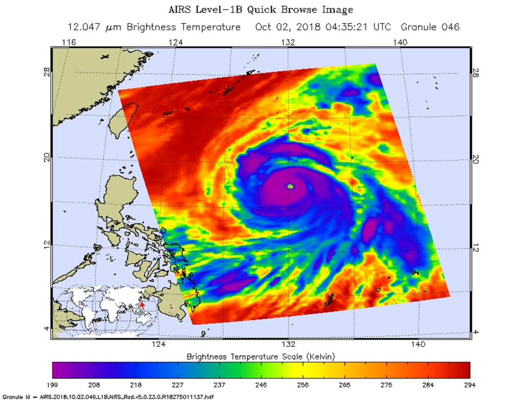
NASA’s Aqua satellite provided an infrared view of Super Typhoon Kong-Rey as it continued tracking through the Northwestern Pacific Ocean. Another Super typhoon, Trami, passed through the same area one week ago and cooler waters it left in its wake are expected to affect Kong-Rey.
NASA’s Aqua satellite passed over Super Typhoon Kong-Rey on Oct. 2 at 12:35 a.m. EDT (0435 UTC) and analyzed it in infrared light. Powerful storms circled a clear eye (purple). Credit: NASA JPL, Heidar Thrastarson
NASA’s Aqua satellite passed over Super Typhoon Kong-Rey on Oct. 2 at 12:35 a.m. EDT (0435 UTC) and the Atmospheric Infrared Sounder or AIRS instrument aboard analyzed cloud top temperatures in infrared light. Coldest cloud top temperatures were being pushed northeast of center and were as cold as or colder than 208 Kelvin (minus 85.2 degrees Fahrenheit/minus 65.1 Celsius). Cloud top temperatures that cold indicate strong storms that have the capability to create heavy rain.
The Joint Typhoon Warning Center noted at 11 a.m. EDT (1500 UTC), “Animated enhanced infrared satellite imagery shows Kong-Rey has maintained a well-defined eye with deep convection wrapping around it. However, the deep convection [strong development of thunderstorms] has become slightly less symmetric over the past several hours, especially in the northeast quadrant.
The center of Super Typhoon Kong-Rey was located near latitude 19.2 degrees north and longitude 130.9 degrees east. Kong-Rey is currently about 493 nautical miles south-southeast of Kadena Air Base, Okinawa Island, Japan. Kong-Rey is moving toward the northwest. Maximum sustained winds have decreased to near 155 mph (250 kph/135 knots).
Kong-Rey will continue to encounter cooler sea surface temperatures by Oct. 3 which are a result of upwelling (bringing cooler water from the ocean bottom to the surface) produced by Super Typhoon Trami which passed through the area several days ago.
Oct. 01, 2018 – Typhoon Kong-rey Moving through Northwestern Pacific
At 11 am EDT (1500 UTC) on Oct 1 , Kong-rey was located near 16.8 north and 134.4 east, about 488 miles north-northwest of Yap. It was moving to the northwest and had maximum sustained winds near 125 knots gusting to 150 knots. Currently the only threatened landmasses are the Ryuku Islands.
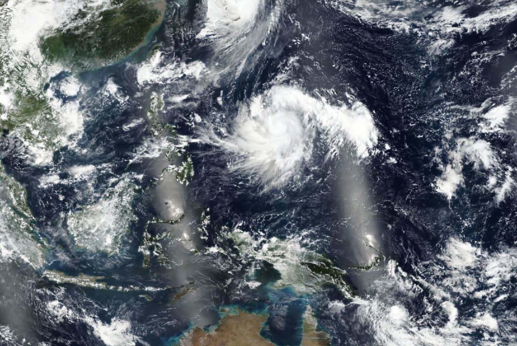
Satellites captured this worldview image of Typhoon Kong-rey on September 30, 2018. Courtesy: NASA Worldview, Earth Observing System Data and Information System (EOSDIS).
This satellite image was taken on September 30, 2018 by NASA’s Earth Observing System Data and Information System (EOSDIS) Worldview application which provides the capability to interactively browse over 700 global, full-resolution satellite imagery layers and then download the underlying data. Many of the available imagery layers are updated within three hours of observation, essentially showing the entire Earth as it looks “right now. ”
Kong-rey will move northwest, intensifying steadily. The storm will peak at 135 knots later today, after which it will steadily weaken. The system will gradually veer north, into the Yellow Sea after three days.