Oct. 01, 2018 – Satellite Sees Extra-Tropical Cyclone Trami Moving Past Japan
NOAA’s NOAA-20 satellite captured a visible image of Typhoon Trami on Oct. 1 after it had become extra-tropical and moved away from Japan.
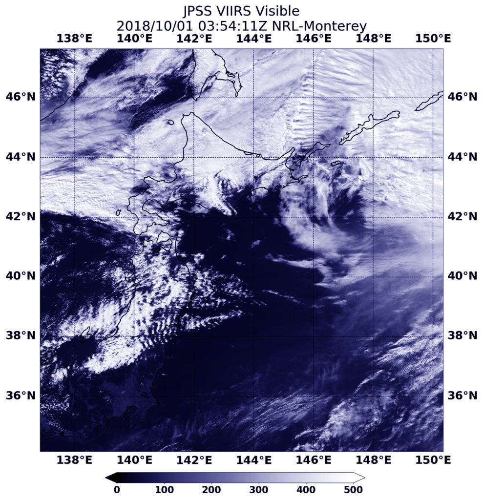
On Oct. 1 at 11:54 p.m. EDT (Sept. 30 at 0354 UTC) the VIIRS instrument aboard NOAA’s NOAA-20 polar orbiting satellite provided a visible image of Trami. The imagery showed the storm’s circulation had eroded quickly and was being blown apart by winds. On Oct. 1, Trami passed Hokkaido and had become extra-tropical. Credit: NOAA/NRL
At 11 a.m. EDT (1500 UTC) on Sunday, Sept. 30, the Joint Typhoon Warning Center issued the final advisory on the system. At that time, Typhoon Trami was located about 157 miles west-southwest of Camp Fuji, Japan and moving northeast at 28 knots (32 mph/52 kph). Maximum sustained winds were near 75 knots (86 mph/139 kph). Trami was weakening rapidly and becoming extra-tropical as it tracked very rapidly over Honshu.
On Oct. 1 at 11:54 p.m. EDT (Sept. 30 at 0354 UTC) the VIIRS instrument aboard NOAA’s NOAA-20 polar orbiting satellite provided a visible image of Trami. The imagery showed the storm’s circulation had eroded quickly and was being blown apart by winds. By Oct. 1, Trami passed Hokkaido and had become extra-tropical.
Sep. 28, 2018 – NASA Finds Trami an Organized, Wide-Eyed Typhoon
Visible imagery from NASA’s Aqua satellite revealed Typhoon Trami was symmetrical and had a large eye on its approach to Japan’s southern islands.
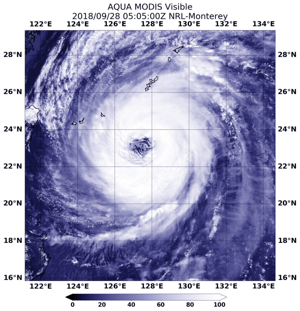
At 1:05 a.m. EDT (0505 UTC) on Sept. 28, the MODIS instrument aboard NASA’s Aqua satellite provided a visible image of Typhoon Trami that revealed a clear eye and a powerful storm. Credit: NASA/NRL
At 1:05 a.m. EDT (0505 UTC) on Sept. 28 the Moderate Resolution Imaging Spectroradiometer or MODIS instrument aboard NASA’s Aqua satellite provided a visible image of Typhoon Trami in the Northwestern Pacific Ocean. The image showed the northwestern edge of Trami beginning to affect the Ryukyu Arc, a chain of Japanese islands that stretch southwest from Kyushu to Taiwan. Infrared satellite imagery shows Trami continues to have a wide eye with convection around the eye beginning to re-intensify.
On Sept. 28, the Joint Typhoon Warning Center or JTWC noted that Trami had maximum sustained winds near 90 knots (103.6 mph/166.7 kph). It was centered near 24.2 degrees north latitude and 127.0 degrees east longitude. That’s 168 nautical miles south-southwest of Kadena Air Base, Okinawa, Japan. Trami was moving north-northwest and is forecast to turn to the north-northeast.
JTWC has forecast the eye of Trami to pass just to the west of Okinawa Island, Japan and Omami Oshima Island as it moves in a north-northeasterly direction.
NASA-NOAA’s Suomi NPP satellite passed over the eye of Typhoon Trami as it continued moving through the Northwestern Pacific Ocean.
On Sept. 27 the VIIRS instrument aboard NASA-NOAA’s Suomi NPP satellite captured a visible image of Powerful Typhoon Trami with a ragged eye. Credit: NASA Worldview, Earth Observing System Data and Information System (EOSDIS)
On Sept. 27, 2018, the Visible Infrared Imaging Radiometer Suite (VIIRS) instrument aboard NASA-NOAA’s Suomi NPP satellite a visible image of Trami. VIIRS infrared imagery showed a wide and ragged eye and deep convection and developing thunderstorms around. That thunderstorm development increased during the morning hours.
At 11 a.m. EDT (1500 UTC) on Sept. 27, the eye of Typhoon Trami was located near latitude 22.2 degrees north and longitude 128.6 degrees east. That’s about 275 miles south-southeast of Kadena Air Base, Okinawa Island, Japan. Maximum sustained winds were near 90 knots (103.6 mph/166.7 kph).
The Joint Typhoon Warning Center or JTWC noted that “Trami remains in a weak steering environment while in between a subtropical ridge (elongated area of high pressure) located to the west and a second subtropical ridge located to the east.” Trami is expected to eventually move to the northeast but it is forecast to re-intensify before weakening.
Sep. 26, 2018 – NASA-NOAA’s Suomi NPP Satellite Gets an Infrared View Typhoon Trami
Typhoon Trami looked formidable in infrared imagery taken from NASA-NOAA’s Suomi NPP satellite as it moves to the southern Islands of Japan.
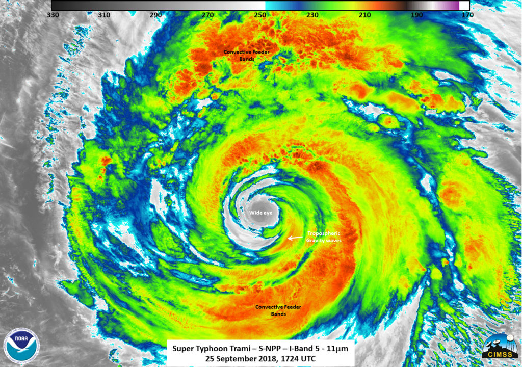
The VIIRS instrument on the Suomi NPP satellite flew over Typhoon Trami at 1724 UTC (1:24 p.m. EDT) on Sept. 25. Cloud top temperatures were near 190 Kelvin/-117.7F/-83.5C around the eye of the storm. Credit: UWM/SSEC/CIMSS, William Straka III
NASA-NOAA’s Suomi NPP satellite provided forecasters with a night-time and infrared look at Trami’s clouds on Sept. 25 at 1724 UTC (1:24 p.m. EDT). Cloud top temperatures were near 190 Kelvin/ minus 117.7 degrees Fahrenheit / minus 83.5 degrees Celsius around the eye of the storm. Cloud tops that cold can produce heavy rainfall.
William Straka III of the University of Wisconsin-Madison, Space Science and Engineering Center (SSEC) Cooperative Institute for Meteorological Satellite Studies (CIMSS), Madison, created the images. Straka said, “The infrared imagery showed a wide eye along with the obvious convection and tropospheric gravity waves.”
At 11 a.m. EDT (1500 UTC) Trami’s center was located near latitude 21.3 North, longitude 129.3 West. That’s about 321 nautical miles south-southeast of Kadena Air Base, Okinawa, Japan. Maximum sustained winds are near 103 mph (90 knots/166 kph) with higher gusts.
The Joint Typhoon Warning Center forecast calls for Trami to weaken slowly as the storm moves slowly north. The storm will then re-strengthen to 110 knots, after which it will become extra-tropical. The typhoon will become extra-tropical on passing Honshu.
Sep. 25, 2018 – Super Typhoon Trami’s Rainfall Examined By NASA/JAXA’s GPM Satellite
The Global Precipitation Measurement mission or GPM core observatory satellite probed super typhoon Trami when it traveled above the northwestern Pacific Ocean and provided an analysis of heavy rainfall and cloud top heights.
The GPM core satellite flew over Trami on Sept. 24, 2018 at 8:03 a.m. EDT (1203 UTC) and found extremely heavy rainfall in the super typhoon’s well defined circular eye. Rain was also falling at a rate of over 120 mm (4.7 inches) per hour within intense storms in a strong feeder band well southwest of Trami’s eye. Credit: NASA/JAXA, Hal Pierce
GPM, a joint satellite mission between NASA and the Japan Aerospace Exploration Agency, JAXA, flew over Trami on Sept. 24, 2018 at 8:03 a.m. EDT (1203 UTC). At that time Trami had maximum sustained winds estimated at 130 knots (150 mph). Rainfall measurements were made using data collected by GPM’s Microwave Imager (GMI) and Dual-Frequency Precipitation Radar (DPR) instruments. GPM’s GMI showed the locations of extremely heavy rainfall in the super typhoon’s well defined circular eye.
GPM’s radar (DPR Ku Band) coverage was limited because its swath only included storms on the western side of the typhoon. GPM’s DPR showed that rain was falling at a rate of over 120 mm (4.7 inches) per hour within intense storms in a strong feeder band well southwest of Trami’s eye.
The Joint Typhoon Warning Center (JTWC) used that GPM pass in an evaluation of super typhoon Trami. JTWC’s summary and analysis said that, “A 241201Z (Sept 24 at 8:01 a.m. EDT/1201 UTC) GPM 89GHZ microwave image clearly reveals an ongoing eyewall replacement cycle with concentric rings and a moat feature evident.”
On Sept. 25 at 5 a.m. EDT (0900 UTC) Super Typhoon Trami had maximum sustained winds near 155.4 mph (135 knots/250 kph). It was located near 19.9 degrees north latitude and 128.9 degrees east longitude, about 401 miles south of Kadena Air Base, Okinawa, Japan. Trami is moving slowly to the north-northeast. At that time, animated enhanced infrared satellite imagery depicts a symmetric eyewall surrounding a 35 nautical mile-wide oblong eye.
Trami will weaken very slowly as the storm crawls north. After two days, the system will speed up as it continues to weaken, eventually veering northeast. Trami is expected to still have winds of about 100 knots (115 mph) when it moves into the East China Sea northeast of Taiwan on September 29, 2018.
Sep. 24, 2018 – NASA’s Terra Satellite Glares at the 37-Mile Wide Eye of Super Typhoon Trami
NASA’s Terra satellite provided a visible image of Super Typhoon Trami as it continued moving in a northwesterly direction in the Northwestern Pacific Ocean. Terra provided an amazing image of the large eye.
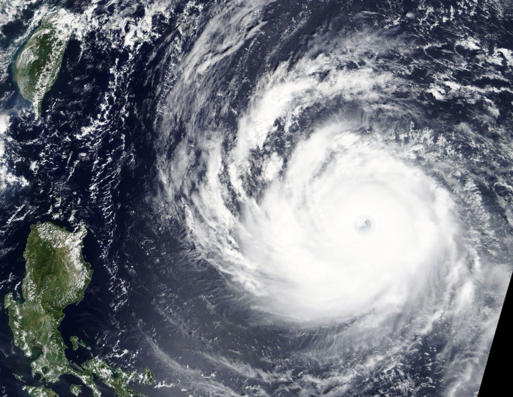
At 9:50 a.m. EDT (1350 UTC) on Sept. 24, the MODIS instrument aboard NASA’s Terra satellite provided a visible-light image of Super Typhoon Trami in the North Western Pacific Ocean. Credit: NASA Worldview, Earth Observing System Data and Information System (EOSDIS).
At 9:50 a.m. EDT (1350 UTC) on Sept. 24, the Moderate Resolution Imaging Spectroradiometer or MODIS instrument aboard NASA’s Terra satellite provided a visible-light image of Super Typhoon Trami in the North Western Pacific Ocean.
The MODIS image showed that Trami has a symmetric eyewall surrounding a 37 nautical-mile round eye.
At 11 a.m. EDT (1500 UTC) on Sept. 24 the center of Super Typhoon Trami was located near latitude 19.4 degrees north and longitude 129.5 degrees east. It is located 445 nautical miles south-southeast of Kadena Air Base, Okinawa Island, Japan.
The Joint Typhoon Warning Center noted that the storm is moving toward the wet-northwest and this general motion is expected to continue. Maximum sustained winds are near 149.6 mph (130 knots/240.8 kph) with higher gusts.
Trami is expected to peak at 167 mph (145 knots/268 kph) in the next day before beginning a weakening trend.
Sep. 21, 2018 – NASA Sees Areas of Strength in Tropical Storm Trami
NASA’s Terra satellite provided an infrared look at Tropical Storm Trami, located just over 100 miles from Guam on Sept. 21. Infrared data provides temperature information that showed two areas of the highest, coldest cloud tops and most powerful storms within the tropical storm.
At 8:45 a.m. EDT (1245 UTC) on Sept.21 the MODIS instrument aboard NASA’s Terra satellite looked at Tropical Storm Trami (28W) in infrared light. MODIS found coldest cloud top temperatures in two large areas, as cold as or colder than minus 80 degrees (yellow) Fahrenheit (minus 112 degrees Celsius). Surrounding them were powerful storms with cloud tops as cold as or colder than minus 70 degrees (red) Fahrenheit (minus 56.6 degrees Celsius). Credit: NASA/NRL
NOAA’s National Weather Service (NWS) in Tiyan, Guam said that a flash flood watch is in effect for all of Guam and the northern Marianas. A small craft advisory remains in effect until 6 a.m. CHST local time on Sunday, Sept. 23.
However, the Tropical Storm Watch for Rota, Tinian and Saipan has been canceled. Because Tropical Storm Trami (28W) continues to move away from the Marianas the threat of damaging winds has ended.
At 2:20 a.m. EDT (0230 UTC) on Sept. 13, Moderate Resolution Imaging Spectroradiometer or MODIS instrument aboard NASA’s Aqua satellite analyzed Hurricane Florence in infrared light. MODIS found coldest cloud top temperatures in two large areas. One was around the center of circulation and the other was in a thick band of thunderstorms wrapping into the low-level center. Those temperatures were as cold as or colder than minus 80 degrees Fahrenheit (minus 112 degrees Celsius). Surrounding them were powerful storms with cloud tops as cold as or colder than minus 70 degrees Fahrenheit (minus 56.6 degrees Celsius).
NASA research has found that cloud top temperatures as cold as or colder than the 70F/56.6C threshold have the capability to generate heavy rainfall.
On Sept. 21, Trami was located near latitude 15.3 degrees north and longitude 142.9 degrees east. That’s about 175 miles west-northwest of Rota and about 180 miles northwest of Guam. Trami is moving northwest at 12 mph. It is expected to make a slight turn toward the west-northwest with little change in forward speed over the next 24 hours. Maximum sustained winds have increased to 40 mph. 28W is forecast to intensify through Saturday. Tropical storm force winds extend outward from the center up to 120 miles.
NWS issued a special weather statement for Micronesia that said areas of heavy showers and thunderstorms can be found near Trami and in the monsoon flow southwest of the storm. The westerly monsoonal flow across Yap State and the Republic of Palau will increase during the next few days. Showery weather and locally gusty winds are likely for Yap and Koror through this weekend. Sea and surf conditions may become hazardous at times.